Coordinates: 41°32′N48°41′E / 41.533°N 48.683°E

A geographic coordinate system is a coordinate system that enables every location on Earth to be specified by a set of numbers, letters or symbols. The coordinates are often chosen such that one of the numbers represents a vertical position and two or three of the numbers represent a horizontal position; alternatively, a geographic position may be expressed in a combined three-dimensional Cartesian vector. A common choice of coordinates is latitude, longitude and elevation. To specify a location on a plane requires a map projection.
| Gadzhyrustamoba | |
|---|---|
 Gadzhyrustamoba | |
| Coordinates: 41°32′N48°41′E / 41.533°N 48.683°E | |
| Country | |
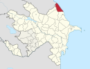
| Rayon | Khachmaz |
| Time zone | AZT (UTC+4) |
| • Summer (DST) | AZT (UTC+5) |
Gadzhyrustamoba (also, Gadzhirustamoba) is a village in the Khachmaz Rayon of Azerbaijan. In Soviet times the village was the location of a small military base, which was dissolved in 1992. The military base was used as a testing ground for the T-72 tank, as the location in a semi-desert proved useful to assess the reliability of the tank in dusty and hot conditions.

Azerbaijan, officially the Republic of Azerbaijan, is a country in the South Caucasus region of Eurasia at the crossroads of Eastern Europe and Western Asia. It is bounded by the Caspian Sea to the east, Russia to the north, Georgia to the northwest, Armenia to the west and Iran to the south. The exclave of Nakhchivan is bounded by Armenia to the north and east, Iran to the south and west, and has an 11 km long border with Turkey in the northwest.

The T-72 is a family of Soviet main battle tanks that first entered production in 1971. About 20,000 T-72 tanks were built, making it one of the most widely produced post-World War II tanks, second only to the T-54/55 family. The T-72A version introduced in 1979 is considered a second-generation main battle tank. It was widely exported and saw service in 40 countries and in numerous conflicts. The T-72B3 version introduced in 2010 is considered a third-generation main battle tank.