Krasnı Xutor

Last updated

Coordinates: 41°34′06″N48°48′11″E / 41.56833°N 48.80306°E / 41.56833; 48.80306

Geographic coordinate system Coordinate system

A geographic coordinate system is a coordinate system that enables every location on Earth to be specified by a set of numbers, letters or symbols. The coordinates are often chosen such that one of the numbers represents a vertical position and two or three of the numbers represent a horizontal position; alternatively, a geographic position may be expressed in a combined three-dimensional Cartesian vector. A common choice of coordinates is latitude, longitude and elevation. To specify a location on a plane requires a map projection.

Krasnı Xutor
Azerbaijan adm location map.svg
Red pog.svg
Krasnı Xutor
Coordinates: 41°34′06″N48°48′11″E / 41.56833°N 48.80306°E / 41.56833; 48.80306
CountryFlag of Azerbaijan.svg  Azerbaijan
Rayon Khachmaz
Municipality Yataqoba
Time zone AZT (UTC+4)
  Summer (DST) AZT (UTC+5)

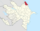
Krasnı Xutor (also, Krasnyy Khutor) is a village in the Khachmaz Rayon of Azerbaijan. The village forms part of the municipality of Yataqoba. [1]

Azerbaijan Country in the South Caucasus

Azerbaijan, officially the Republic of Azerbaijan, is a country in the South Caucasus region of Eurasia at the crossroads of Eastern Europe and Western Asia. It is bounded by the Caspian Sea to the east, Russia to the north, Georgia to the northwest, Armenia to the west and Iran to the south. The exclave of Nakhchivan is bounded by Armenia to the north and east, Iran to the south and west, and has an 11 km long border with Turkey in the northwest.

Yataqoba Municipality in Khachmaz, Azerbaijan

Yataqoba is a village and municipality in the Khachmaz Rayon of Azerbaijan. It has a population of 1,045. The municipality consists of the villages of Yataqoba, Krasnı Xutor, and Mecidoba.

Related Research Articles

Kavilo Village in Vojvodina, Serbia

Kavilo is a village in Serbia. It is situated in the Bačka Topola municipality, in the North Bačka District, Vojvodina province. The village has a Hungarian ethnic majority. Its population was 233 in the 2002 census.

Piçənis Place in Lachin, Azerbaijan

Piçənis is a village in the Lachin Rayon of Azerbaijan.

Novonikolayevka, Azerbaijan Place in Quba, Azerbaijan

Novonikolayevka is a village in the Quba Rayon of Azerbaijan. The village forms part of the municipality of Hacıhüseynli.

Gədik Place in Quba, Azerbaijan

Gədik is a former village in the Quba Rayon of Azerbaijan. The village formed part of the municipality of Gədikqışlaq.

Ağarəhimoba Place in Khachmaz, Azerbaijan

Ağarəhimoba is a village in the Khachmaz Rayon of Azerbaijan. The village forms part of the municipality of Qadaşoba.

Hacıəhmədoba Place in Khachmaz, Azerbaijan

Hacıəhmədoba is a village in the Khachmaz Rayon of Azerbaijan. The village forms part of the municipality of Əhmədoba.

Dağdağan Place

Dağdağan is a village in the Khojali Rayon of Azerbaijan. Since the Nagorno-Karabakh war the village has been administered by the de facto Nagorno-Karabakh Republic as part of Askeran Province.

Tsakuri Place

Tsakuri is a village in the Khojavend Rayon of Azerbaijan.

Bad, Azerbaijan Place in Quba, Azerbaijan

Bad is a village in the Quba Rayon of Azerbaijan. The village forms part of the municipality of Rustov.

Adur, Azerbaijan Place in Quba, Azerbaijan

Adur is a village in the Quba Rayon of Azerbaijan. The village forms part of the municipality of Qarxun.

Kolkhoz Krasnyy Oktyabr Village in Ujar, Azerbaijan

Kolkhoz Krasnyy Oktyabr is a village in the Ujar Rayon of Azerbaijan.

Meşəli, Khachmaz Place in Khachmaz, Azerbaijan

Meşəli is a village in the Khachmaz Rayon of Azerbaijan. The village forms part of the municipality of Nabran.

Şimal Place in Khachmaz, Azerbaijan

Şimal is a village in the Khachmaz Rayon of Azerbaijan. The village forms part of the municipality of Nabran.

Ballıqaya, Goranboy Place in Goranboy, Azerbaijan

Ballıqaya is a village in the Goranboy Rayon of Azerbaijan. The village forms part of the municipality of Qızılhacılı.

Dębniałki is a village in the administrative district of Gmina Blizanów, within Kalisz County, Greater Poland Voivodeship, in west-central Poland.

Bystrzec Village in Pomeranian, Poland

Bystrzec is a name of non existing village in the administrative district of Gmina Kwidzyn, within Kwidzyn County, Pomeranian Voivodeship, in northern Poland. It lay approximately 8 kilometres (5 mi) north of Kwidzyn and 67 km (42 mi) south of the regional capital Gdańsk.

Sapuny is a settlement in the administrative district of Gmina Barczewo, within Olsztyn County, Warmian-Masurian Voivodeship, in northern Poland.

Twarogi is a village in the administrative district of Gmina Goleniów, within Goleniów County, West Pomeranian Voivodeship, in north-western Poland.

Predvorica Village in Mačva District, Serbia

Predvorica is a village in the municipality of Šabac, Serbia. According to the 2002 census, the village has a population of 469 people.

ATO Congresium

The ATO Congresium is an international convention and exhibition center in Ankara, Turkey. It is a property of the Ankara Trade Chamber (ATO). It is at 39°54′41″N32°48′11″E on Söğütözü Boulevard. It opened on 14 September 2012.

References

  1. "Belediyye Informasiya Sistemi" (in Azerbaijani). Archived from the original on September 24, 2008.

The GEOnet Names Server (GNS) provides access to the National Geospatial-Intelligence Agency's (NGA) and the U.S. Board on Geographic Names's (BGN) database of geographic feature names and locations for locations outside the United States. The database is the official repository of foreign place-name decisions approved by the US BGN. Approximately 20,000 of the database's features are updated monthly. The database never removes an entry, "except in cases of obvious duplication".