Gaiberg

Last updated • 1 min readFrom Wikipedia, The Free Encyclopedia
Gaiberg
Gaiberger Ortsmittelpunk.jpg
Downtown Gaiberg with City Hall and the Protestant Church
DEU Gaiberg COA.svg
Location of Gaiberg within Rhein-Neckar-Kreis district
Gaiberg in HD.svgEberbachBrühlEberbachEberbachEberbachLaudenbachLeimenLeimenMalschMauerMühlhausenRauenbergSchönauSchönbrunnSpechbachWiesenbach
Germany adm location map.svg
Red pog.svg
Gaiberg
Baden-Wuerttemberg location map.svg
Red pog.svg
Gaiberg
Coordinates: 49°22′N8°45′E / 49.367°N 8.750°E / 49.367; 8.750 Coordinates: 49°22′N8°45′E / 49.367°N 8.750°E / 49.367; 8.750
Country Germany
State Baden-Württemberg
Admin. region Karlsruhe
District Rhein-Neckar-Kreis
Municipal assoc. Neckargemünd
Government
   Mayor (201826) Petra Müller-Vogel [1]
Area
  Total4.15 km2 (1.60 sq mi)
Elevation
293 m (961 ft)
Population
 (2021-12-31) [2]
  Total2,380
  Density570/km2 (1,500/sq mi)
Time zone UTC+01:00 (CET)
  Summer (DST) UTC+02:00 (CEST)
Postal codes
69251
Dialling codes 06223
Vehicle registration HD

Gaiberg is a municipality in the Rhein-Neckar-Kreis of Baden-Württemberg.

Contents

Geography

The state certified climatic health resort (Luftkurort) sits on the border of the Odenwald and the Kraichgau within the Neckartal-Odenwald national park, about 10 km south of Heidelberg.

To the south of Gaiberg lies Leimen. To the north and west lies Heidelberg. To the east lies Bammental.

History

The settlement which appeared in the late Middle Ages, was bought by the Electorate of the Palatinate in 1419. In 1803 Gaiberg became part of Baden.

Government

Gaiberg belongs to the Neckargemünd municipal association. The seat of the municipal association is in Neckargemünd.

Municipal council

In addition to the chairperson and mayor, there are 12 councilors.

Coat of arms

The coat of arms is based on a court seal from 1751. It depicts a column next to a tree. The meaning of the symbols is not explained. In 1900 the municipality adopted the coat of arms at the suggestion of the General State Archiv.

The flag is green and white and was awarded by the Ministry of the Interior in 1956.

Sister cities

Flag of France.svg La Canourgue, France

Economy and infrastructure

Transportation

The municipality connect to the regional highway net by 8 km of state road to the exit Heidelberg/Schwetzingen of Bundesautobahn 5.

Education

In Gaiberg there is a primary and secondary school with a vocational school. Schools for further education can be found in Leimen and Heidelberg. There are Gymnasien in Neckargemünd and Bammental.

(German) Official Website

Related Research Articles

<span class="mw-page-title-main">Schönbrunn (Baden)</span> Municipality in Baden-Württemberg, Germany

Schönbrunn is a municipality in the Rhein-Neckar district, Baden-Württemberg, Germany. It consists of the villages Allemühl, Haag, Moosbrunn, Schönbrunn and Schwanheim. It is situated in the southern part of the Odenwald hills, south of the river Neckar. Schönbrunn lies about 7 km southwest of Eberbach and 18 km east of Heidelberg.

<span class="mw-page-title-main">Mudau</span> Municipality in Baden-Württemberg, Germany

Mudau is a municipality in the Neckar-Odenwald district, Baden-Württemberg, Germany. As of 2013 it has 4,833 inhabitants.

<span class="mw-page-title-main">Illingen, Baden-Württemberg</span> German municipality

Illingen is a municipality in Baden-Württemberg, Germany. With a population of about 10,000, it is 27 kilometers (89,000 ft) to the west of Stuttgart, the capital of Baden-Württemberg.

<span class="mw-page-title-main">Nußloch</span> Municipality in Baden-Württemberg, Germany

Nußloch  is a municipality in the Rhein-Neckar-Kreis (Baden-Württemberg), about 10 km south of Heidelberg. It is on a much traveled tourist route: Bergstraße and Bertha Benz Memorial Route. The hamlet Maisbach also belongs to Nußloch.

<span class="mw-page-title-main">Freudenberg (Baden)</span> Town in Baden-Württemberg, Germany

Freudenberg is a town and a municipality in the district Main-Tauber-Kreis, in Baden-Württemberg, Germany. It is situated on the river Main and has a population around 3,700.

<span class="mw-page-title-main">Eberbach (Baden)</span> Town in Baden-Württemberg, Germany

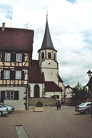
Eberbach is a town in Germany, in northern Baden-Württemberg, located 33 km east of Heidelberg. It belongs to the Rhein-Neckar-Kreis. Its sister cities are Ephrata, United States and Thonon-les-Bains, France.

<span class="mw-page-title-main">Eppelheim</span> Town in Baden-Württemberg, Germany

Eppelheim is a city in northern Baden-Württemberg bordering Heidelberg. It belongs to the district Rhein-Neckar-Kreis.

<span class="mw-page-title-main">Edingen-Neckarhausen</span> Municipality in Baden-Württemberg, Germany

Edingen-Neckarhausen is a municipality in the district of Rhein-Neckar-Kreis, in Baden-Württemberg, Germany. It is situated on the left bank of the Neckar.

<span class="mw-page-title-main">Hemsbach</span> Town in Baden-Württemberg, Germany

Hemsbach is a town with approximately 12,000 inhabitants in the Rhein-Neckar-Kreis of Baden-Württemberg, Germany. It belongs to the European Rhine-Neckar Metropolitan Region. It is situated on the Bergstraße, 18 km northeast of Mannheim. Hemsbach was twinned with Wareham, Dorset in the UK in 1986.

<span class="mw-page-title-main">Mauer (Baden)</span> Municipality in Baden-Württemberg, Germany

Mauer is a village in south western Germany. It is located between Heidelberg and Sinsheim in the Rhein-Neckar district in the state of Baden-Württemberg.

<span class="mw-page-title-main">Schönau (Odenwald)</span> Town in Baden-Württemberg, Germany

Schönau is a city with approximately 4400 inhabitants in the district of Rhein-Neckar-Kreis, in Baden-Württemberg, Germany. It is situated in the Odenwald hills, 10 km northeast of Heidelberg. Schönau Abbey is located here.

<span class="mw-page-title-main">Zwingenberg (Baden)</span> German municipality

Zwingenberg is a village in the Neckar-Odenwald district, in Baden-Württemberg, Germany.

<span class="mw-page-title-main">Bammental</span> Municipality in Baden-Württemberg, Germany

Bammental is a municipality in Rhein-Neckar Kreis of Baden-Württemberg.

<span class="mw-page-title-main">Epfenbach</span> Municipality in Baden-Württemberg, Germany

Epfenbach is a municipality in south western Germany. It is located between Heidelberg and Sinsheim in the Rhein-Neckar district in the state of Baden-Württemberg. The municipality belongs to the municipal association of Waibstadt and the tourist region Brunnenregion.

<span class="mw-page-title-main">Zuzenhausen</span> Municipality in Baden-Württemberg, Germany

Zuzenhausen is a municipality in Baden-Württemberg and is part of the Rhein-Neckar-Kreis.

<span class="mw-page-title-main">Spechbach, Baden-Württemberg</span> Municipality in Baden-Württemberg, Germany

Spechbach is a town in the district of Rhein-Neckar in Baden-Württemberg in Germany.

<span class="mw-page-title-main">Wilhelmsfeld</span> Municipality in Baden-Württemberg, Germany

Wilhelmsfeld is a municipality in the Rhein-Neckar-Kreis of Baden-Württemberg in Germany.

<span class="mw-page-title-main">Odenwald Railway (Baden)</span> Railway line in Germany

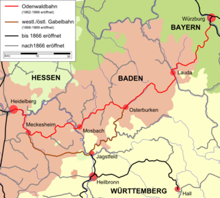
The Odenwald Railway was the name given to a Baden railway line in southwestern Germany built from between 1862 and 1866. It ran from Heidelberg via Neckargemünd and Meckesheim through the Little Odenwald mountains to Waibstadt, Mosbach, Osterburken and Lauda to Würzburg in Bavaria.

<span class="mw-page-title-main">Elsenz Valley Railway</span>

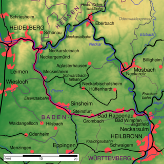
The Elsenz Valley Railway (Elsenztalbahn) or Neckargemünd–Bad Friedrichshall railway is an electrified, partly double-tracked main line in the German state of Baden-Württemberg, running from Heidelberg via Sinsheim to Bad Friedrichshall, that, for part of its course, follows the Elsenz river that gives it its name. The crossing stations on the single-tracked sections were controlled by mechanical signal boxes until 2008, but are now controlled by electronic interlockings.

<span class="mw-page-title-main">Kleiner Odenwald</span>

The Kleiner Odenwald is the southern part of the central German hill range, the Odenwald, and is up to 567.8 m above sea level (NHN). It is also part of the natural region of Sandstein-Odenwald in the north of the state of Baden-Württemberg. Lying east-southeast of Heidelberg and south of the River Neckar, which separates the Kleiner Odenwald from the rest of the Odenwald, its landscape is shaped by the underlying sandstone that also dominates the northern Odenwald.

References

  1. Aktuelle Wahlergebnisse, Staatsanzeiger, accessed 14 September 2021.
  2. "Bevölkerung nach Nationalität und Geschlecht am 31. Dezember 2021" [Population by nationality and sex as of December 31, 2021](CSV) (in German). Statistisches Landesamt Baden-Württemberg. June 2022.