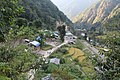
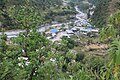
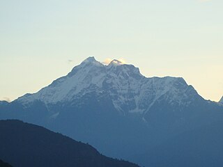
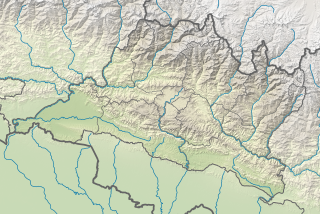
Rolwāling Himāl, , knows as a (Gaurishankar) rural municipality, is a section of the Himalayas in east-central Nepal along the Tibet border. Rolwaling Himal includes Melungtse 7181m and Melungtse II 7023m inside Tibet and Gaurishankar 7134m on the Nepal border with some 50 additional peaks over 6000m, all extending from the Nangpa La pass where the Mahalangur section begins, southwest to the Tamakosi River. The Labuche Himal section rises beyond the Tamakosi to the northwest. Rolwaling Himal is bounded on the south by the Rolwaling Valley which contain several small sherpa villages Tasi Nam, Simigau and Beding under rolwaling valley, Tasi Nam is the largest town of the area. Five to six days are required to reach Namche Bazaar after Tasilapcha pass. Visitors can trek to Everest base camp by crossing Tasilapcha or fly from Kathmandu to Lukla.

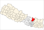
Dolakha, often known as Dolkha or Dholkha, a part of Bagmati Province, is one of the seventy-seven districts of Nepal. The district, with Charikot as its district headquarters, covers an area of 2,191 km2 (846 sq mi) and has a population of 204,229 in 2001 and 186,557 in 2011. It is a district with a strong religious affiliation. It is popularly known amongst most Nepalese for the temple of Dolakha Bhimeshawor.

Makwanpur District(Nepali: मकवानपुर जिल्लाListen , a part of Bagmati Province, earlier a part of Narayani Zone, is one of the seventy-seven districts of Nepal. The district, with Hetauda as its district headquarter, as well as pradesh headquarter covers an area of 2,426 km2 and had a population of 392,604 in 2001 and 420,477 in 2011.

Nuwakot District (Nepali: नुवाकोट जिल्लाListen , a part of Bagmati Province, is one of the seventy-seven districts of Nepal. The district, with Bidur as its district headquarters, covers an area of 1,121 km2 and had a population of 288,478 in 2001 and 277,471 in 2011. It is a historically important district in Nepal. Prithvi Narayan Shah died in Devighat of Nuwakot.

RolpaListen (help·info), is a "hill" district in Lumbini Province of Nepal. Rolpa district covers an area of 1,879 km2 (725 sq mi) with population (2011) of 221,177. Rolpa town is the district's administrative center.

Sarlahi, a part of Province No. 2, is one of the seventy-seven districts of Nepal. According to new laws, combination of more than 2 or 4 villages makes a municipality, which covers an area of 1,259 km2 (486 sq mi) and had a population of 635,701 in 2001 and 769,729 in 2011.

Rolpa is a municipality located in Rolpa District of Lumbini Province of Nepal. It is only municipality of Rolpa District. The municipality is surrounded by Sunchhahari and Swarnawati rural councils from the east, Tribeni & Madi rural councils from the West, Duikholi rural council from the North and Swarnawati & Runtigadhi from the South

Bhimeshwar,, is a municipality in north-eastern Nepal and the headquarters of Dolakha District in Bagmati Pradesh that was established in 1997 by merging the former Village development committees Charikot, Dolakha Town, Makaibari and Mati. At the time of the 2011 Nepal census it had a population of 32,486 people living in 8,639 individual households. The town is located at an altitude of 1554 metres (5101 feet). The name of the district Dolakha came from Dolakha Town situated north-east of the headquarters Charikot Bazaar.

Gaurishankar is currently referred to as Ward No. 9 under Gaurishankar Rural Municipality in Bagmati Pradesh, Dolakha District of Nepal. At the time of the 1991 Nepal census it had a population of 1392 people living in 291 individual households. There are divided to 3 villages which are Tasi Nam, simi gau and beding.

Kalinchok is a former village development committee that is now a Rural Municipality in Dolakha District in Bagmati Pradesh of north-eastern Nepal. At the time of the 1991 Nepal census it had a population of 2261 people living in 458 individual households.
Gaurishankar Conservation Area is a protected area in the Himalayas of Nepal that was established in January 2010, covering 2,179 km2 (841 sq mi) in the Ramechhap, Dolakha and Sindhupalchok districts and encompassing 22 Village Development Committees. It is contiguous with Tibet in the north. The protected area connects the Langtang and Sagarmatha National Parks. The Government of Nepal handed over the management of Gaurishankar Conservation Area to National Trust for Nature Conservation (NTNC) for 20 years in 2010. Following the models of Annapurna and Manaslu Conservation Areas, NTNC has been managing the area through its Gaurishankar Conservation Area Project.
Majhgaun is a village where the headquarters of the Chhetrapa Village Development Committee are located in Kshetrapa(Majhgau-माझगाउँ) in Dolakha District in Bagmati Pradesh of north-eastern Nepal.

Bagmati Province is one of the seven provinces of Nepal established by the constitution of Nepal as of 20 September 2015. With Hetauda as its provincial headquarter, the province is the home to the country's capital Kathmandu, is mostly hilly and mountainous, and hosts mountain peaks including Gaurishankar, Langtang, Jugal, and Ganesh. The province covers an area of 20,300 km2 - about 13.76% of the country's total area, and has an altitude low enough to support deciduous, coniferous, and alpine forests and woodlands. Temperature varies with altitude. Rainfall takes place mainly during the summer.

Gosaikunda is a rural municipality located in Rasuwa District of Bagmati Pradesh in Nepal. Rasuwa district is divided into five rural municipality and Gosaikunda is one of them. It is located near the border of Tibet-China on Himalayan range. It is surrounded by Sindhupalchok District in east, Naukunda gaunpalika and Kalika gaunpalika in south and Uttargaya gaunpalika and Parbatikunda gaunpalika in west. Tibet is located on the north side of the rural municipality. Total area of the rural municipality is 987.77 square kilometres (381.38 sq mi) and total population is 7,143 individuals.

Bhotekoshi is a rural municipality located in Sindhupalchok District of Bagmati Pradesh in Nepal. Sindhupalchok district is divided into twelve local level units, in which three units are urban municipality and nine are rural municipality and Bhotekoshi is one of rural municipalities out of nine. It is located near the border of Tibet-China on Himalayan range. It is surrounded by Dolakha District in east, Bahrabise in south and Jugal in west. Tibet is located on the north side of the rural municipality. Total area of the rural municipality is 273.62 square kilometres (105.65 sq mi) and total population is 19231 individuals.
Shailung is a rural municipality located within the Dolakha District of the Bagmati Province of Nepal. The municipality spans 96.30 square kilometres (37.18 sq mi) of area, with a total population of 20,098 according to a 2011 Nepal census.
Baiteshwor is a rural municipality located within the Dolakha District of the Bagmati Province of Nepal. The municipality spans 80.41 square kilometres (31.05 sq mi) of area, with a total population of 19,876 according to a 2011 Nepal census.
Tamakoshi is a rural municipality located within the Dolakha District of the Bagmati Province of Nepal. The municipality spans 153.06 square kilometres (59.10 sq mi) of area, with a total population of 18,849 according to a 2011 Nepal census.