Gaviota Hot Springs

Last updated

Gaviota Hot Springs
Las Cruces Hot Springs
Sulphur Springs
2018.12.23 Gaviota Hot Springs (04) (32704494988).jpg
Gaviota Hot Springs
LocationNear Las Cruces, Santa Barbara County, California, U.S.
Coordinates 34°30′10″N120°13′06″W / 34.5027°N 120.2184°W / 34.5027; -120.2184
Elevation500 feet (150 m)
Type geothermal
Temperature99 °F (37 °C)

Gaviota Hot Springs is a geothermal feature in Santa Barbara County, California, United States. The two pools are accessible from the Gaviota Peak trail in Gaviota State Park. [1] Gaviota Hot Springs is sometimes called Las Cruces Hot Springs or Sulphur Springs. [2] The hot springs lie within the Hot Springs Creek watershed, near the junction of U.S. Route 101 and California State Route 1. [3]

Contents

History

The springs were known to the indigenous peoples of the area, [4] and are located on land that was Rancho Las Cruces during the Mexican era of California. As early as 1880 there was a hotel at the village of Las Cruces advertising the medicinal benefits of the nearby hot sulfur springs. [5] The hotel was an adobe tavern on the side of the road that also served as the local brothel. [6]

A 1893 account of camping at the springs describes hanging hammocks from the sycamores around the pool, and needing to clear accumulated mud out of the roughly 8 feet (2.4 m) by 10 feet (3.0 m) bathing hole before it could be enjoyed by the group. [7] In 1896 the third edition of California of the South claimed that the Las Cruces Springs "had quite a local reputation for curing skin diseases and rheumatism." [8] In 1907 a promotional booklet published by California boosters described Las Cruces as one of three known hot springs in Santa Barbara County: [9]

Las Cruces Hot Springs [are] found in the Gaviota Cañon, a remarkable gorge that cleaves in twain the Santa Ynez Range, and down which a creek flows from the interior of the county. They are about 40 miles from Santa Barbara, some four miles the coast, and have been but slightly improved. It is a favorite camping-ground, and all the privileges of the springs are free to all who come.

Detail of Hot Springs canon from 1880 plat of Rancho Las Cruces Circa 1880 map detail of Rancho Las Cruces plat Las Cruces Hot Springs aka Gaviota Hot Springs.jpg
Detail of Hot Springs cañon from 1880 plat of Rancho Las Cruces

The village of Las Cruces, located four miles north of Gaviota Pass, claimed circa 1913 that "The Hot Springs here are famous." [10] According to a 1917 report of the California state minerals bureau, the springs were located on the Las Cruces ranch and owned by the Hollister Estate Co. of Santa Barbara, and at that time "a group of 4 warm sulphuretted springs flowing about 50 gallons per minute issues from a clay bank on a hillside. The water is piped to the ranch houses for local use. Not utilized commercially." [11] One of the two pools is a man-made rock-and-concrete basin that was built by the Works Progress Administration during the New Deal era of the 1930s. [12] [4] During the same era, the Civilian Conservation Corps paved East Camino Cielo between the springs area and the San Marcos Pass. [13] The other pool has a natural bottom, and is fed by a separate spring vent, which is said to be the source of the lower pool's lukewarm temperature and the milky appearance of its water. [12] [14] Circa 1968, the springs were still associated with the Hollister Estate Company. [15] The springs were known as a litter-strewn party spot during the counterculture and underground days of the 1960s and 1970s. [4] [16]

The trail and springs are now regularly maintained by state park employees and volunteers; the springs and the park are open to the public during daylight hours. [17] [4] Mountain lions are among the wildlife that frequent the area. [18] [19] The springs are surrounded by native riparian-habitat plants including elderberry, willows, sycamores, and poison oak, [4] [14] and a naturalized palm tree that contributes an oasis vibe to the landscape. [17] A guide to hot springs in California and Nevada states, “Despite its murky appearance, this hot spring provides a great soak. The surrounding vegetation makes you feel like you’re in a jungle, and it keeps the location cool." [20]

Water profile

The springs lie along the southern branch of the Santa Ynez Fault. [21] The water emerges from the source at about 99 °F (37 °C) [22] but cools before it reaches the pools. [2] The temperature also varies with the season. [2] The upper pool is typically both warmer and clearer than the lower pool, which it feeds. [23] The water contains sodium bicarbonate. [15] According to a U.S. government survey done around 1962, "spring issues in a dense thicket on hillside and is piped to concrete bathing tub." [15] The springs smell noticeably sulfurous, [14] and typically are described as being closer to warm than to hot. [4] [24]

U.S. government geologist Gerald A. Waring described Las Cruces Hot Springs in 1915: [25]

Las Cruces Hot Springs issue on a hillside about 18 miles (29 km) west of San Marcos Hot Springs and 4 miles (6.4 km) northward from Gaviota railroad station on the coast. Four warm springs here furnish about 50 US gallons (190 L; 42 imp gal) a minute of mildly sulphureted water and in two of the springs inflammable gas rises. A ledge of calcareous material back of the largest springs probably has been formed by deposition from the water. In 1908 there was a bathhouse at the largest spring, and the place was occasionally visited by campers. The topographic position of the springs is worthy of note, as they are in a little swale on the mountain side one half mile from and 400 feet above the main drainage canyon of this region. Thick-bedded sandstone here dips about 30° SW and strikes nearly in the direction of steepest slope.

One newspaper article from 1984 stated that Gaviota springs are "unusual inasmuch as tritium dating shows the water to be about 38 years old, coming from a depth of about 3,280 feet (1,000 m), with water temperature of 115 °F (46 °C) and a rate of flow of 25 US gallons (95 L; 21 imp gal) a minute." [17]

See also

Related Research Articles

<span class="mw-page-title-main">Santa Ynez Mountains</span> Mountain range of the Transverse Ranges in California, United States

The Santa Ynez Mountains are a portion of the Transverse Ranges, part of the Pacific Coast Ranges of the west coast of North America. It is the westernmost range in the Transverse Ranges.

<span class="mw-page-title-main">Gaviota State Park</span> State park in Gaviota, California, United States

Gaviota State Park is a state park of California, United States. It is located in southern Santa Barbara County, California, about 33 miles (53 km) west of the city of Santa Barbara. One of three state parks along the Gaviota Coast, it extends from the Pacific coast to the crest of the Santa Ynez Mountains, and is adjacent to Los Padres National Forest. The 2,787-acre (1,128 ha) park was established in 1953.

<span class="mw-page-title-main">Santa Ynez River</span> River in California, United States

The Santa Ynez River is one of the largest rivers on the Central Coast of California. It is 92 miles (148 km) long, flowing from east to west through the Santa Ynez Valley, reaching the Pacific Ocean at Surf, near Vandenberg Space Force Base and the city of Lompoc.

<span class="mw-page-title-main">Gaviota Tunnel</span> Tunnel along US Route 101 in Gaviota State Park, California, United States

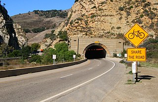
The Gaviota Tunnel is a tunnel on U.S. Route 101/State Route 1 (US 101/SR 1) completed in 1953 in the center of Gaviota State Park, 33 miles (53 km) northwest of Santa Barbara, California, on the Gaviota Coast. It is 420 feet (130 m) long and 17.5 feet (5.3 m) tall. Only the northbound lanes of US 101 pass through it, as the southbound lanes descend from Gaviota Pass through a narrow canyon to the west of the tunnel. Because it is the only major route between the Santa Barbara County South Coast and the Santa Ynez Valley, bicycles are allowed through it. There is a rest area for both southbound and northbound lanes on the southern end of the tunnel, the southernmost one along US 101.

<span class="mw-page-title-main">San Marcos Pass</span> Mountain pass in California, United States

San Marcos Pass is a mountain pass in the Santa Ynez Mountains in southern California.

<span class="mw-page-title-main">Gaviota, California</span> Unincorporated community in California, United States

Gaviota is an unincorporated community in Santa Barbara County, California on the Gaviota Coast about 30 miles (48 km) west of Santa Barbara and 15 miles (24 km) south of Buellton.

<span class="mw-page-title-main">Los Encinos State Historic Park</span> State park in Los Angeles County

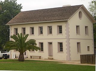
Los Encinos State Historic Park is a state park unit of California, preserving buildings of Rancho Los Encinos. The park is located near the corner of Balboa and Ventura Boulevards in Encino, California, in the San Fernando Valley. The rancho includes the original nine-room de la Ossa Adobe, the two-story limestone Garnier building, a blacksmith shop, a natural spring, and a pond. The 4.7-acre (1.9 ha) site was established as a California state park in 1949.

<span class="mw-page-title-main">Gaviota Peak</span>

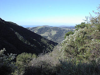
Gaviota Peak is a summit in the Santa Ynez Mountains in Santa Barbara County, California. It is located 10 miles (16 km) west of Santa Barbara, 16 miles (26 km) east of Point Conception and 2 miles (3.2 km) from the Pacific Ocean.

Rancho Las Cruces was a 8,888-acre (35.97 km2) Mexican land grant in the Santa Ynez Mountains of present-day Santa Barbara County, California given in 1837 by Governor Juan B. Alvarado to Miguel Cordero. The name means "the crosses". The grant was inland of present-day Gaviota Beach and the Gaviota Tunnel.

<span class="mw-page-title-main">Las Cruces, California</span> Archaic placename in Santa Barbara County, California

Las Cruces is a former settlement and an archaic placename in Santa Barbara County, California. It lies at the split between California State Route 1, which travels north to Lompoc, and U.S. Route 101, which travels north to Buellton. The two routes coincide on the highway to the south through the Gaviota Gorge to the Gaviota Coast. The community lies within area code 805.

<span class="mw-page-title-main">Sisquoc Formation</span>

The Sisquoc Formation is a sedimentary geologic unit widespread in Southern California, both on the coast and in mountains near the coast. Overlying the Monterey Formation, it is of upper Miocene and lower Pliocene age. The formation consists of claystone, mudstone, siltstone, shale, diatomite, and conglomerates, with considerable regional variation, and was deposited in a moderately deep marine environment at a depth of approximately 500–5,000 feet (150–1,520 m). Since some of its diatomites, along with those of the underlying Monterey Formation, are of unusual purity and extent, they can be mined as diatomaceous earth. France-based Imerys operates a mine in the Sisquoc and Monterey Formations in the hills south of Lompoc, California, the largest such operation in the world.

<span class="mw-page-title-main">Coldwater Sandstone</span> Eocene geologic unit in Southern California

The Coldwater Sandstone is a sedimentary geologic unit of Eocene age found in Southern California, primarily in and south of the Santa Ynez Mountains of Santa Barbara County, and east into Ventura County. It consists primarily of massive arkosic sandstone with some siltstone and shale. Being exceptionally resistant to erosion, outcrops of the Coldwater form some of the most dramatic terrain on the south slope of the Santa Ynez Mountains, with immense white sculpted slabs forming peaks, hogback ridges, and sheer cliff faces.

<span class="mw-page-title-main">Matilija Sandstone</span> Southern California geological formation

The Matilija Sandstone is a sedimentary geologic unit of Eocene epoch in the Paleogene Period, found in Santa Barbara and Ventura Counties in Southern California.

<span class="mw-page-title-main">Juncal Formation</span> Prominent sedimentary geologic unit of the Eocene age in California

The Juncal Formation is a prominent sedimentary geologic unit of Eocene age found in and north of the Santa Ynez Mountain range in southern and central Santa Barbara County and central Ventura County, California. An enormously thick series of sediments deposited over millions of years in environments ranging from nearshore to deep water, it makes up much of the crest of the Santa Ynez range north of Montecito, as well as portions of the San Rafael Mountains in the interior of the county. Its softer shales weather to saddles and swales, supporting a dense growth of brush, and its sandstones form prominent outcrops.

<span class="mw-page-title-main">Wheeler Springs, California</span> Unincorporated community in California, United States

Wheeler Springs is an unincorporated community that grew around a set of sulphurated hot springs in Ventura County, California. It is located 6 miles north of the Ojai Valley, within Los Padres National Forest. It is named for Wheeler Blumberg, who founded the town in 1891, and the many natural hot springs.

<span class="mw-page-title-main">Mission San Borja Hot Springs</span> Thermal springs

Mission San Borja Hot Springs are located on the grounds of the historical Misión San Francisco Borja near the town of Rosarito in Baja California, Mexico.

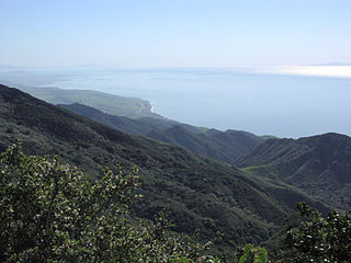
The Gaviota Coast in Santa Barbara County, California is a rural coastline along the Santa Barbara Channel roughly bounded by Goleta Point on the south and the north boundary of the county on the north. This last undeveloped stretch of Southern California coastline consists of dramatic bluffs, isolated beaches and terraced grasslands.

<span class="mw-page-title-main">Cañada Honda Creek</span> River in Santa Barbara County, California, US

Cañada Honda Creek is a perennial stream in Santa Barbara County, California, United States, that lies almost entirely within Vandenberg Space Force Base and meets the Pacific Ocean just north of Point Pedernales. Cañada Honda is part of the larger Santa Barbara coastal plain water resource subbasin.

<span class="mw-page-title-main">Veronica Springs</span> Historic mineral spring, California

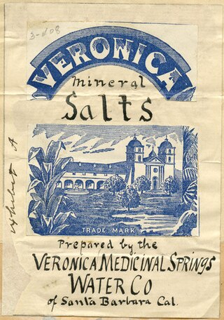
Veronica Springs, also Veronica Medicinal Springs, was a cluster of natural springs along Arroyo Burro creek in Santa Barbara County, California, United States. Veronica spring water was not a therapeutic spa water or a table water but a medicinal mineral water with high magnesium levels. The waters had a yellowish tinge and a strongly purgative-laxative effect, and beginning around 1887, the water was bottled and sold as a health tonic. Veronica Water peaked as a brand in the 1910s. The springs were capped off in 1962.

References

  1. Pawlik, Matt (October 7, 2022). "8 tranquil hot springs in California to heal your weary soul". Los Angeles Times. Archived from the original on 2024-01-20. Retrieved 2024-01-21.
  2. 1 2 3 Andrews, Chris (2022). Hiking Hot Springs in the Southwest: A Guide to the Area's Best Backcountry Hot Springs. Rowman & Littlefield. pp. 92–93. ISBN   978-1-4930-3657-8. Archived from the original on 2024-01-29. Retrieved 2024-01-21.
  3. Loam, Jayson; Gersh, Marjorie (1992). Hot Springs and Hot Pools of the Southwest (Rev. ed.). Santa Cruz, Calif.: Aqua Thermal Access. p. 110. ISBN   0-9624830-4-4.
  4. 1 2 3 4 5 6 Cappon, Sally (April 15, 2008). "'Warm Springs' Once a Hot Spot". Best of Roadside Attractions. Santa Maria Times. pp. A3. Archived from the original on 2024-01-29. Retrieved 2024-01-21.
  5. "Las Cruces Hotel". The Lompoc Record. December 18, 1880. p. 2. Archived from the original on 2024-01-29. Retrieved 2024-01-21.
  6. Dale, Judith (May 12, 2020). "Las Cruses: The forgotten crossroad". Santa Ynez Valley News. pp. B1. Archived from the original on 2024-01-29. Retrieved 2024-01-21. & "Dale [part 2 of 2]". Santa Ynez Valley News. May 12, 2020. pp. B3. Archived from the original on 2024-01-27. Retrieved 2024-01-21.
  7. Squire (August 5, 1893). "Camping at Las Cruces". The Santa Maria Times. p. 3. Archived from the original on 2024-01-29. Retrieved 2024-01-21.
  8. Lindley, Walter; Widney, J. P. (1896). California of the south: its physical geography, climate, mineral springs, resources, routes of travel and health-resorts, being a complete guide-book (3rd ed.). pp. 302–303. hdl:2027/nnc1.cu01636065. Archived from the original on 2024-01-29. Retrieved 2024-01-21 via HathiTrust.
  9. Gidney, C. M. (April 1907). "The Mineral Springs of Santa Barbara County". For California: A Monthly Publication. Springs Number. Vol. IV, no. 5. San Francisco: California Promotion Committee. p. 11. hdl:2027/mdp.39015082352025. Archived from the original on 2024-01-29. Retrieved 2024-01-21 via Biodiversity Heritage Library & HathiTrust. PD-icon.svg This article incorporates text from this source, which is in the public domain .
  10. Wilson, Leila Weekes (1913). Santa Barbara, California. Santa Barbara, Calif.: Pacific Coast Publ. Co. pp. 91–92. hdl:2027/nyp.33433081782629. Archived from the original on 2024-01-29. Retrieved 2024-01-21 via HathiTrust.
  11. Bradley, Walter W. (1917). "Mineral Springs of Ventura County". Mines and Mineral Resources of the Counties of Monterey, San Benito, San Luis Obispo, Santa Barbara, Ventura. State Mineralogist's Reports. Field Assistants: Emile Huguenin, C. A. Logan, Clarence A. Waring. Ferry Building, San Francisco: California State Mining Bureau. p. 147. Archived from the original on 2023-11-11. Retrieved 2024-01-21 via HathiTrust.
  12. 1 2 Carey, Craig R. (June 19, 2012). Hiking and Backpacking Santa Barbara and Ventura. Wilderness Press. p. 35. ISBN   978-0-89997-635-8. Archived from the original on 2024-01-29. Retrieved 2024-01-21.
  13. Cappon, Sally (July 27, 2010). "A mystery still lingers in San Marcos Pass". The Lompoc Record. pp. A2. Archived from the original on 2024-01-29. Retrieved 2024-01-21.
  14. 1 2 3 Best, Jennifer (October 1, 2000). "Gaviota Hot Springs: The bare necessities". Santa Maria Times. p. 37. Archived from the original on 2024-01-29. Retrieved 2024-01-21.
  15. 1 2 3 Berkstresser, C. F. (1968). Data for Springs in the Southern Coast, Transverse, and Peninsular Ranges of California. U.S. Department of the Interior, Geological Survey, Water Resources Division. Archived from the original on 2024-01-29. Retrieved 2024-01-21.
  16. "In Old Santa Barbara: 75 Years Ago". Santa Barbara News-Press. April 2, 1960. p. 14. Archived from the original on 2024-01-29. Retrieved 2024-01-21.
  17. 1 2 3 Stob, Ron (October 13, 1984). "Back Roads: Nature's Best Bath Yours at Hot Springs". The Tribune. p. 60. Archived from the original on 2024-01-29. Retrieved 2024-01-21.
  18. "Gaviota Beach". Santa Maria Times. March 27, 1992. p. 5. Archived from the original on 2024-01-29. Retrieved 2024-01-21.
  19. "In Old Santa Barbara: 75 Years Ago". Santa Barbara News-Press. April 2, 1960. p. 14. Archived from the original on 2024-01-29. Retrieved 2024-01-21.
  20. Bischoff, Matt C. (2018). "48. Gaviota State Park Hot Spring (Las Cruces)". Touring California and Nevada Hot Springs. Touring Hot Springs. FalconGuides. ISBN   978-1-4930-2912-9.
  21. Cappon, Sally (January 1, 2013). "It's not hard to find fault around here". Santa Maria Times. pp. A4. Archived from the original on 2024-01-29. Retrieved 2024-01-21.
  22. Berry, G.W.; Grim, P.J.; Ikelman, J.A. (June 1980). Thermal Springs List for the United States (Report). Key to Geophysical Records Documentation No. 12. Environmental Data and Information Service National Geophysical and Solar-Terrestrial Data Center. Boulder, Colo.: U.S. Department of Commerce, National Oceanic and Atmospheric Administration (NOAA). p. 12. doi:10.2172/6737326. Archived from the original on 2023-11-17. Retrieved 2024-01-21.
  23. Marshall, Justin D. (May 26, 2016). Santa Ynez Cycling: A Complete Guide to the Best Mountain Bike Rides of the Region, Including Several of the Most Popular Road Cycling Routes. Lulu.com. p. 62. ISBN   978-1-4834-4506-9. Archived from the original on 2024-01-22. Retrieved 2024-01-21.
  24. McKinney, John (September 23, 1989). "Enjoy Coastal Vistas from the Top of Gaviota Peak". The Los Angeles Times. p. 88. Archived from the original on 2024-01-29. Retrieved 2024-01-21.
  25. Waring, Gerald Ashley (January 1915). Springs of California. U.S. Department of the Interior, Geological Survey Water-Supply Papers. Washington, D.C.: U.S. Government Printing Office. p. 68. doi:10.3133/wsp338. Water Supply Paper No. 338. Archived from the original on 2023-12-11 via HathiTrust. PD-icon.svg This article incorporates text from this source, which is in the public domain .