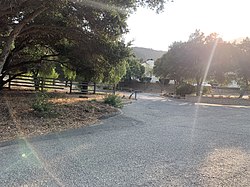
Las Cruces, California

Last updated

Las Cruces, California
Las Cruces California.jpg
Las Cruces, August 2021
USA California location map.svg
Red pog.svg
Las Cruces, California
Coordinates: 34°30′29″N120°13′45″W / 34.50806°N 120.22917°W / 34.50806; -120.22917
Country United States
State California
County Santa Barbara
Elevation
341 ft (104 m)
Time zone UTC-8 (Pacific (PST))
  Summer (DST) UTC-7 (PDT)
Area code(s) 805 & 820
GNIS feature ID1660894 [1]

Las Cruces (sometimes rendered Las Cruses, meaning the crosses in Spanish) [2] is a former settlement and an archaic placename in Santa Barbara County, California. [1] It lies at the split between California State Route 1, which travels north to Lompoc, and U.S. Route 101, which travels north to Buellton. The two routes coincide on the highway to the south through the Gaviota Gorge to the Gaviota Coast. The community lies within area code 805.

Contents

History

There was a post office at Las Cruces as early as 1876. [3] The spot has long been a crossroads for travellers along the Central Coast. [4] In the 19th century, Las Cruces "was an overnight stop-over for farmers delivering grain and other crops from the Santa Ynez Valley to the Gaviota Wharf." [5]

Gaviota Hot Springs were originally known as Las Cruces Hot Springs because of its proximity to the village. [6] Locals used the springs for bathing. [7]

The population of Las Cruces in 1941 was 64 people. [8] Las Cruces was fairly busy during World War II, when it attracted visitors from Camp Cooke, now Vandenberg Space Force Base. [9] It was said to have been a "small community" as of the 1950s. [8] The village is said to have been "obliterated" by highway construction. [7] The Las Cruces village store was demolished in December 1967 to make way for the interchange. [9]

Additional images

Related Research Articles

<span class="mw-page-title-main">California State Route 1</span> State highway in California, United States

State Route 1 (SR 1) is a major north–south state highway that runs along most of the Pacific coastline of the U.S. state of California. At 656 miles (1,056 km), it is the longest state route in California, and the second-longest in the US after Montana Highway 200. SR 1 has several portions designated as either Pacific Coast Highway (PCH), Cabrillo Highway, Shoreline Highway, or Coast Highway. Its southern terminus is at Interstate 5 (I-5) near Dana Point in Orange County and its northern terminus is at U.S. Route 101 (US 101) near Leggett in Mendocino County. SR 1 also at times runs concurrently with US 101, most notably through a 54-mile (87 km) stretch in Ventura and Santa Barbara counties, and across the Golden Gate Bridge.

<span class="mw-page-title-main">Santa Barbara County, California</span> County in California, United States

Santa Barbara County, officially the County of Santa Barbara, is located in Southern California. As of the 2020 census, the population was 448,229. The county seat is Santa Barbara, and the largest city is Santa Maria.

<span class="mw-page-title-main">Los Alamos, California</span> Place in California, United States

Los Alamos is an unincorporated community in Santa Barbara County, California, United States. Located in the Los Alamos Valley, the town of Los Alamos is considered to be a part of the Santa Ynez Valley community. Los Alamos is also connected to other cities Vandenberg SFB, Lompoc, Buellton, Solvang, and other Santa Barbara County cities. It is 140 miles northwest of Los Angeles and 281 miles (452 km) south of San Francisco. The population was 1,890 at the 2010 census, up from 1,372 at the 2000 census. For statistical purposes, the United States Census Bureau has defined Los Alamos as a census-designated place (CDP).

<span class="mw-page-title-main">Santa Ynez Mountains</span> Mountain range of the Transverse Ranges in California, United States

The Santa Ynez Mountains are a portion of the Transverse Ranges, part of the Pacific Coast Ranges of the west coast of North America. It is the westernmost range in the Transverse Ranges.

The State Scenic Highway System in the U.S. state of California is a list of highways, mainly state highways, that have been designated by the California Department of Transportation (Caltrans) as scenic highways. They are marked by the state flower, a California poppy, inside either a rectangle for state-maintained highways or a pentagon for county highways.

<span class="mw-page-title-main">Gaviota State Park</span> State park in Gaviota, California, United States

Gaviota State Park is a state park of California, United States. It is located in southern Santa Barbara County, California, about 33 miles (53 km) west of the city of Santa Barbara. One of three state parks along the Gaviota Coast, it extends from the Pacific coast to the crest of the Santa Ynez Mountains, and is adjacent to Los Padres National Forest. The 2,787-acre (1,128 ha) park was established in 1953.

<span class="mw-page-title-main">Santa Ynez River</span> River in California, United States

The Santa Ynez River is one of the largest rivers on the Central Coast of California. It is 92 miles (148 km) long, flowing from east to west through the Santa Ynez Valley, reaching the Pacific Ocean at Surf, near Vandenberg Space Force Base and the city of Lompoc.

<span class="mw-page-title-main">Santa Ynez Valley</span> Valley in California, United States of America

The Santa Ynez Valley is located in Santa Barbara County, California, between the Santa Ynez Mountains to the south and the San Rafael Mountains to the north. The Santa Ynez River flows through the valley from east to west. The Santa Ynez Valley is separated from the Los Alamos Valley, to the northwest, by the Purisima Hills, and from the Santa Maria Valley by the Solomon Hills. The Santa Rita Hills separate the Santa Ynez Valley from the Santa Rita and Lompoc Valleys to the west.

<span class="mw-page-title-main">Gaviota Tunnel</span> Tunnel along US Route 101 in Gaviota State Park, California, United States

The Gaviota Tunnel is a tunnel on U.S. Route 101 and California State Route 1 completed in 1953 in the center of Gaviota State Park, 33 miles (53 km) northwest of Santa Barbara, California on the Gaviota Coast. It is 420 feet (130 m) long and 17.5 feet (5.3 m) tall. Only the northbound lanes of US 101 pass through it, as the southbound lanes descend from Gaviota Pass through a narrow canyon to the west of the tunnel. Because it is the only major route between the Santa Barbara County South Coast and the Santa Ynez Valley, bicycles are allowed through it. There is a rest area for both southbound and northbound lanes on the southern end of the tunnel, the southernmost one along U.S. Route 101.

<span class="mw-page-title-main">California State Route 246</span> Highway in California

State Route 246 is a state highway in the U.S. state of California that runs from Lompoc east to Solvang and Santa Ynez, cutting through the Santa Ynez Valley and the Santa Barbara Wine Country. Its western terminus is at the western city limits of Lompoc, and its eastern terminus is at State Route 154 near Santa Ynez.

<span class="mw-page-title-main">San Marcos Pass</span> Mountain pass in California, United States

San Marcos Pass is a mountain pass in the Santa Ynez Mountains in southern California.

<span class="mw-page-title-main">Cold Spring Canyon Arch Bridge</span> Bridge in Santa Barbara County, California

The Cold Spring Canyon Arch Bridge in the Santa Ynez Mountains links Santa Barbara, California with Santa Ynez, California. The bridge is signed as part of State Route 154.

<span class="mw-page-title-main">Gaviota, California</span> Unincorporated community in California, United States

Gaviota is an unincorporated community in Santa Barbara County, California on the Gaviota Coast about 30 miles (48 km) west of Santa Barbara and 15 miles (24 km) south of Buellton.

Gaviota is the Spanish word for "seagull". It may refer to:

<span class="mw-page-title-main">Gaviota Peak</span>

Gaviota Peak is a summit in the Santa Ynez Mountains in Santa Barbara County, California. It is located 10 miles (16 km) west of Santa Barbara, 16 miles (26 km) east of Point Conception and 2 miles (3.2 km) from the Pacific Ocean.

Rancho Las Cruces was a 8,888-acre (35.97 km2) Mexican land grant in the Santa Ynez Mountains of present-day Santa Barbara County, California given in 1837 by Governor Juan B. Alvarado to Miguel Cordero. The name means "the crosses". The grant was inland of present-day Gaviota Beach and the Gaviota Tunnel.

<span class="mw-page-title-main">Sisquoc Formation</span>

The Sisquoc Formation is a sedimentary geologic unit widespread in Southern California, both on the coast and in mountains near the coast. Overlying the Monterey Formation, it is of upper Miocene and lower Pliocene age. The formation consists of claystone, mudstone, siltstone, shale, diatomite, and conglomerates, with considerable regional variation, and was deposited in a moderately deep marine environment at a depth of approximately 500–5,000 feet (150–1,520 m). Since some of its diatomites, along with those of the underlying Monterey Formation, are of unusual purity and extent, they can be mined as diatomaceous earth. France-based Imerys operates a mine in the Sisquoc and Monterey Formations in the hills south of Lompoc, California, the largest such operation in the world.

<span class="mw-page-title-main">Matilija Sandstone</span> Southern California geological formation

The Matilija Sandstone is a sedimentary geologic unit of Eocene epoch in the Paleogene Period, found in Santa Barbara and Ventura Counties in Southern California.

The Gaviota Coast in Santa Barbara County, California is a rural coastline along the Santa Barbara Channel roughly bounded by the city of Goleta on the south and the north boundary of the county on the north. This last undeveloped stretch of Southern California coastline consists of dramatic bluffs, isolated beaches and terraced grasslands.

<span class="mw-page-title-main">Gaviota Hot Springs</span> Geothermal site in California

Gaviota Hot Springs is a geothermal feature in Santa Barbara County, California, United States. The two pools are accessible from the Gaviota Peak trail in Gaviota State Park. Gaviota Hot Springs is sometimes called Las Cruces Hot Springs or Sulphur Springs.

References

  1. 1 2 U.S. Geological Survey Geographic Names Information System: Las Cruces, California
  2. Gannett, Henry (1905). The Origin of Certain Place Names in the United States. U.S. Government Printing Office. p.  182.
  3. U.S. Post Office Department, "California: San Mateo – Santa Clara Counties (Roll 65)", M1126: Post Office Department Reports of Site Locations, 1837–1950, Washington, D.C.: U.S. National Archives and Records Administration, film images 353–356 of 789, NAID 68237020 via archives.gov
  4. McMahon, Marilyn (February 13, 2021). "Special school: Vista de Las Cruces project among architect's favorites". Santa Barbara News-Press. Retrieved February 20, 2021.
  5. "Crumbling Las Cruces Adobe Patiently Waits Future Course". Santa Ynez Valley News. April 13, 1972. p. 6. Retrieved January 21, 2024. & "Adobe [part 2 of 2]". Santa Ynez Valley News. April 13, 1972. p. 7. Retrieved January 21, 2024.
  6. "Wilson, Leila Weekes. Santa Barbara, California. Santa Barbara, Calif.: Pacific Coast Publ. Co., 1913". HathiTrust. pp. 91–92. Retrieved January 21, 2024.
  7. 1 2 Cappon, Sally (April 15, 2008). "'Warm Springs' Once a Hot Spot". Best of Roadside Attractions. Santa Maria Times. pp. A3. Retrieved January 21, 2024.
  8. 1 2 Dale, Judith (May 12, 2020). "Las Cruses: The forgotten crossroad". Santa Ynez Valley News. pp. B1. Retrieved January 21, 2024. & "Dale [part 2 of 2]". Santa Ynez Valley News. May 12, 2020. pp. B3. Retrieved January 21, 2024.
  9. 1 2 "Old Las Cruces Store Gives Way to New Interchange". Santa Ynez Valley News. January 11, 1968. p. 9. Retrieved January 21, 2024.

Further reading