Mission Canyon, California

Last updated
Mission Canyon
SBCA SantaYnez NB 20170912.jpg
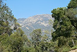
View of the Santa Ynez Mountains from a southernmost point of Mission Canyon (at the intersection of Mountain Dr. & Mission Ridge Rd.)
Santa Barbara County California Incorporated and Unincorporated areas Mission Canyon Highlighted.svg
Location in Santa Barbara County and the state of California
Coordinates: 34°26′59″N119°42′59″W / 34.44972°N 119.71639°W / 34.44972; -119.71639
Country Flag of the United States (23px).png  United States
State Flag of California.svg  California
County Santa Barbara
Government
   State senator Monique Limón (D) [1]
   Assemblymember Gregg Hart (D) [1]
   U. S. rep. Salud Carbajal (D) [2]
Area
[3]
  Total1.547 sq mi (4.008 km2)
  Land1.517 sq mi (3.930 km2)
  Water0.030 sq mi (0.078 km2)  1.94%
Elevation
[4]
633 ft (193 m)
Population
  Total2,381
  Density1,500/sq mi (590/km2)
Time zone UTC-8 (Pacific)
  Summer (DST) UTC-7 (PDT)
ZIP code
93105
Area code 805
FIPS code 06-48147
GNIS feature ID 1853400

Mission Canyon is a census-designated place and an unincorporated suburb of Santa Barbara, California, in Santa Barbara County, United States. The population was 2,381 at the 2010 census, down from 2,610 at the 2000 census.

Contents

Mission Canyon is directly north on the mountain side of the city of Santa Barbara, and derives its name from the Mission Santa Barbara which is built between Mission Canyon and the center of the city. The canyon itself is one of the most dramatic in the Santa Ynez Mountains with the locally highest peak, La Cumbre Peak 3,988 ft (1,216 m) [5] at the top of the watershed, flanked by Cathedral Peak 3,336 ft (1,017 m) [6] and Arlington Peak 3,258 ft (993 m) [7] to the west, Pine Lookout and Rock Garden to the east, and rugged sandstone formations partially covered with chaparral on both sides of the creek.

State Route 192 (Foothill Road) bisects the southern portion of the area, running from east to west, and Mission Canyon Road passes through the area from north to south. Another major north-south artery is Tunnel Road, which leads to the trailhead for several popular hiking trails that originates from an area of medium density and semi-rural development at the canyon's northern extremity, and extends into Los Padres National Forest in the Santa Ynez Mountains. [8]

The Santa Barbara Botanic Garden is located in Mission Canyon.

Geography

The Santa Barbara Botanic Garden is in Mission Canyon; this view looks north up the canyon towards the headwaters near Cathedral Peak. SBBotanicGardens2.JPG
The Santa Barbara Botanic Garden is in Mission Canyon; this view looks north up the canyon towards the headwaters near Cathedral Peak.

The approximate center of Mission Canyon is located at 34°26′59″N119°42′59″W / 34.44972°N 119.71639°W / 34.44972; -119.71639 (34.449797, -119.716315). [9] Situated along the southern facing slopes of the Santa Ynez Mountains, Mission Canyon measures some 1,122 acres comprising an estimated 1,141 parcels primarily consisting of single-family residential development, recreational, open space, and agricultural land uses; but however lacks any commercial or industrial development. Non residential features include the Santa Barbara Botanic Garden, Rocky Nook County Park, the Santa Barbara Woman's Club, and the Santa Barbara County Fire Department Fire Station 15. The topography of the neighborhood varies from relatively flat areas located south of Foothill Road to greater slopes north of Foothill Road, ranging in elevations from approximately 300 ft (91 m) to just over 1,000 ft (305 m) above sea level. [8]

According to the United States Census Bureau, the CDP has a total area of 1.5 square miles (3.9 km2), of which 1.5 square miles (3.9 km2) are land and 0.03 square miles (0.078 km2) (1.94%) is water.

Climate

This region experiences warm (but not hot) and dry summers, with no average monthly temperatures above 71.6 °F. According to the Köppen Climate Classification system, Mission Canyon has a warm-summer Mediterranean climate, abbreviated "Csb" on climate maps. [10]

Demographics

2010

The 2010 United States Census [11] reported that Mission Canyon had a population of 2,381. The population density was 1,538.8 inhabitants per square mile (594.1/km2). The racial makeup of Mission Canyon was 2,193 (92.1%) White, 14 (0.6%) African American, 17 (0.7%) Native American, 40 (1.7%) Asian, 11 (0.5%) Pacific Islander, 35 (1.5%) from other races, and 71 (3.0%) from two or more races. Hispanic or Latino of any race were 198 persons (8.3%).

The Census reported that 2,372 people (99.6% of the population) lived in households, 0 (0%) lived in non-institutionalized group quarters, and 9 (0.4%) were institutionalized.

There were 1,020 households, out of which 230 (22.5%) had children under the age of 18 living in them, 547 (53.6%) were opposite-sex married couples living together, 59 (5.8%) had a female householder with no husband present, 20 (2.0%) had a male householder with no wife present. There were 59 (5.8%) unmarried opposite-sex partnerships, and 14 (1.4%) same-sex married couples or partnerships. 264 households (25.9%) were made up of individuals, and 97 (9.5%) had someone living alone who was 65 years of age or older. The average household size was 2.33. There were 626 families (61.4% of all households); the average family size was 2.70.

The population was spread out, with 368 people (15.5%) under the age of 18, 100 people (4.2%) aged 18 to 24, 458 people (19.2%) aged 25 to 44, 973 people (40.9%) aged 45 to 64, and 482 people (20.2%) who were 65 years of age or older. The median age was 51.3 years. For every 100 females, there were 95.5 males. For every 100 females age 18 and over, there were 97.0 males.

There were 1,075 housing units at an average density of 694.7 per square mile (268.2/km2), of which 782 (76.7%) were owner-occupied, and 238 (23.3%) were occupied by renters. The homeowner vacancy rate was 0.8%; the rental vacancy rate was 4.4%. 1,828 people (76.8% of the population) lived in owner-occupied housing units and 544 people (22.8%) lived in rental housing units.

2000

As of the census [12] of 2000, there were 2,610 people, 1,065 households, and 689 families residing in the CDP. The population density was 1,663.6 inhabitants per square mile (642.3/km2). There were 1,115 housing units at an average density of 710.7 per square mile (274.4/km2). The racial makeup of the CDP was 93.64% White, 0.42% African American, 0.15% Native American, 1.30% Asian, 0.04% Pacific Islander, 2.18% from other races, and 2.26% from two or more races. Hispanic or Latino of any race were 6.63% of the population.

There were 1,065 households, out of which 23.5% had children under the age of 18 living with them, 52.6% were married couples living together, 8.1% had a female householder with no husband present, and 35.3% were non-families. 22.3% of all households were made up of individuals, and 6.1% had someone living alone who was 65 years of age or older. The average household size was 2.44 and the average family size was 2.73.

In the CDP the population was spread out, with 16.9% under the age of 18, 5.0% from 18 to 24, 27.8% from 25 to 44, 35.4% from 45 to 64, and 14.9% who were 65 years of age or older. The median age was 45 years. For every 100 females, there were 93.2 males. For every 100 females age 18 and over, there were 93.4 males.

The median income for a household in the CDP was $79,338, and the median income for a family was $103,442. Males had a median income of $57,222 versus $41,131 for females. The per capita income for the CDP was $43,422. About 1.0% of families and 6.8% of the population were below the poverty line, including 1.6% of those under age 18 and 7.4% of those age 65 or over.

Related Research Articles

<span class="mw-page-title-main">Santan, Arizona</span> CDP in Pinal County, Arizona, United States

Santan is an unincorporated community, and former census-designated place (CDP), in Pinal County, Arizona, United States. The settlement was named "Santa Ana" by its Akimel O'odham inhabitants in 1857, and pronounced "Santana".

<span class="mw-page-title-main">Thermalito, California</span> Census designated place in California, United States

Thermalito is a census-designated place (CDP) in Butte County, California, United States. The population was 6,646 at the 2010 census, up from 6,045 at the 2000 census. The area is generally considered an integral part of Oroville, and borders the town on two sides, in addition to the near-enclave of the city of Oroville surrounded by Thermalito on all sides, with the exception of the extremely narrow spit of land connecting Afterbay to Oroville proper.

<span class="mw-page-title-main">Seeley, California</span> Census-designated place in California, United States

Seeley is a census-designated place (CDP) in Imperial County, California. Seeley is located 7.5 miles (12 km) west of El Centro. The population was 1,823 at the 2010 census, up from 1,624 in 2000. It is part of the El Centro Metropolitan Area.

<span class="mw-page-title-main">Las Flores, California</span> Place in California, United States

Las Flores is an unincorporated census-designated place (CDP) in Orange County, California, located adjacent to the City of Rancho Santa Margarita, California. The population was 5,971 at the 2010 census, up from 5,625 at the 2000 census. Las Flores does not have its own ZIP Code and is served by the same ZIP Code as adjacent Rancho Santa Margarita, 92688. The Rancho Santa Margarita dog/skate park is located in the CDP and is served by the Orange County Sheriff's Dept. and Orange County Fire Authority. Although Las Flores lies in the land grant of Rancho Mission Viejo, it is named after the land grant about 25 miles south Rancho Santa Margarita y Las Flores.

<span class="mw-page-title-main">North Tustin, California</span> Place in California, United States

North Tustin is an unincorporated community and census designated place (CDP) in Orange County, California. The population was 25,718 at the 2020 census, up from 24,917 in 2010. For statistical purposes, the United States Census Bureau has defined North Tustin as a census-designated place (CDP). It is both the largest CDP and largest unincorporated community in Orange County. The CDP's name was changed from Tustin Foothills in 2005. Located outside the city limits of Tustin, North Tustin has 92705 and 92780 ZIP Codes.

<span class="mw-page-title-main">Canyondam, California</span> Census-designated place in California, United States

Canyondam is a census-designated place (CDP) in Plumas County, California, United States. Canyondam is located near the dam that forms Lake Almanor, 6.25 miles (10.1 km) east-southeast of Almanor. The population was 31 as of the 2010 census, down from 37 as of the 2000 census. On August 6, 2021, the community was destroyed in the Dixie Fire.

<span class="mw-page-title-main">Nipomo, California</span> Place in California, United States

Nipomo is an unincorporated town in San Luis Obispo County, California, United States. The population was 16,714 for the 2010 census and grew to 18,176 for the 2020 census. For statistical purposes, the United States Census Bureau has defined Nipomo as a census-designated place (CDP).

<span class="mw-page-title-main">Buellton, California</span> City in California, United States

Buellton is a small city in Santa Barbara County, California, United States. It is located in the Santa Ynez Valley, 3 miles (4.8 km) west of Solvang. The population was 5,161 at the 2020 census, up from 4,828 at the 2010 census.

<span class="mw-page-title-main">Los Alamos, California</span> Place in California, United States

Los Alamos is an unincorporated community in Santa Barbara County, California, United States. Located in the Los Alamos Valley, the town of Los Alamos is considered to be a part of the Santa Ynez Valley community. Los Alamos is also connected to other cities Vandenberg SFB, Lompoc, Buellton, Solvang, and other Santa Barbara County cities. It is 140 miles northwest of Los Angeles and 281 miles (452 km) south of San Francisco. The population was 1,890 at the 2010 census, up from 1,372 at the 2000 census. For statistical purposes, the United States Census Bureau has defined Los Alamos as a census-designated place (CDP).

<span class="mw-page-title-main">Mission Hills, Santa Barbara County, California</span> Census-designated place in the U.S. state of California

Mission Hills is a census-designated place (CDP) in Santa Barbara County, California, a short distance north of Lompoc on Highway 1. The population was 3,576 at the 2010 census, up from 3,142 at the 2000 census.

<span class="mw-page-title-main">Montecito, California</span> Town in California

Montecito is an unincorporated town in Santa Barbara County, California, United States. Located on the Central Coast of California, Montecito sits between the Santa Ynez Mountains and the Pacific Ocean. Montecito is best known as a celebrity enclave, owing to its concentration of prominent residents. The population as of 2022 is approximately 8,638 residents. For statistical purposes, the United States Census Bureau has defined Montecito as a census-designated place (CDP).

<span class="mw-page-title-main">Orcutt, California</span> Place in California, United States

Orcutt is an unincorporated town in Santa Barbara County, California, United States. Located in the Santa Maria Valley, Orcutt is named for William Warren Orcutt, the manager of the Geological, Land and Engineering Departments of the Union Oil Company.

<span class="mw-page-title-main">Santa Ynez, California</span> Census-designated place in California, United States

Santa Ynez is a census-designated place (CDP) in the Santa Ynez Valley of Santa Barbara County, California.

<span class="mw-page-title-main">Summerland, California</span> Census designated place in California, United States

Summerland is a census designated place (CDP) in Santa Barbara County, California. The population was 1,448 at the 2010 census, down from 1,545 at the 2000 census.

<span class="mw-page-title-main">Toro Canyon, California</span> Census-designated place in California, United States

Toro Canyon is a census-designated place (CDP) in Santa Barbara County, California, United States. The population was 1,835 at the 2020 census, up from 1,508 at the 2010 census.

<span class="mw-page-title-main">Vandenberg Village, California</span> Census-designated place in California, United States

Vandenberg Village is a census-designated place (CDP) in the unincorporated area of Santa Barbara County, California, United States. The population was 6,497 at the 2010 census, up from 5,802 at the 2000 census.

<span class="mw-page-title-main">Lexington Hills, California</span> Census-designated place in California, United States

Lexington Hills is a census-designated place and an unincorporated area in Santa Clara County, California, United States. The population was 2,492 at the 2020 census. The area is located in the Santa Cruz Mountains, about five miles south of Los Gatos and about 14 miles (23 km) north of Santa Cruz. Lexington Hills is the name assigned by the United States Census Bureau to the area, which actually comprises several small communities, including Redwood Estates, Holy City, Chemeketa Park, and Aldercroft Heights.

<span class="mw-page-title-main">Ballard, California</span> Census-designated place in California, United States

Ballard is a census-designated place in Santa Barbara County, California. The town of Ballard is one of the communities that make up the Santa Ynez Valley. The nearest city is Solvang. The population was 467 at the 2010 census. Ballard is the smallest and oldest community in the Santa Ynez Valley. The town history can be seen in two buildings from the 1880s: the 1883 Ballard School and the Santa Ynez Valley Presbyterian Church, which was erected in 1889. Ballard was founded in 1880.

<span class="mw-page-title-main">Los Olivos, California</span> Unincorporated community in Santa Barbara County, California, US

Los Olivos is an unincorporated community in the Santa Ynez Valley of Santa Barbara County, California, United States. Tourism is popular in this rural area which is an agricultural region with an emphasis on wine grapes. For statistical purposes, the United States Census Bureau has defined Los Olivos as a census-designated place (CDP). The population was 1,132 at the 2010 census. The ZIP Code is 93441, and the community is within the area code 805.

Norris Canyon is a census-designated place in Contra Costa County, California. Norris Canyon sits at an elevation of 1063 feet. The 2010 United States census reported Norris Canyon's population was 957.

References

  1. 1 2 "Statewide Database". UC Regents. Archived from the original on February 1, 2015. Retrieved December 8, 2014.
  2. "California's 24th Congressional District - Representatives & District Map". Civic Impulse, LLC. Retrieved September 29, 2014.
  3. "2010 Census U.S. Gazetteer Files – Places – California". United States Census Bureau.
  4. "Mission Canyon". Geographic Names Information System . United States Geological Survey, United States Department of the Interior . Retrieved April 17, 2015.
  5. "La Cumbre Peak". Washington, US: Peakbagger.com. 1987–2021. Retrieved February 3, 2021.
  6. "Cathedral Peak, California". Washington, US: Peakbagger.com. 1987–2021. Retrieved February 3, 2021.
  7. "Arlington Peak, California". Washington, US: Peakbagger.com. 1987–2021. Retrieved February 3, 2021.
  8. 1 2 Mission Canyon Community Plan (PDF) (Report). Santa Barbara, California: County of Santa Barbara Planning & Development Department: Long Range Planning Division. April 2014. Retrieved 5 November 2021.
  9. "US Gazetteer files: 2010, 2000, and 1990". United States Census Bureau. 2011-02-12. Retrieved 2011-04-23.
  10. Climate Summary for Mission Canyon, California
  11. "2010 Census Interactive Population Search: CA - Mission Canyon CDP". U.S. Census Bureau. Archived from the original on July 15, 2014. Retrieved July 12, 2014.
  12. "U.S. Census website". United States Census Bureau . Retrieved 2008-01-31.