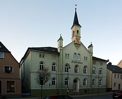
Bornhagen is a municipality in the district of Eichsfeld in Thuringia, Germany, located at the foot of the ruins of Hanstein Castle. The town district Rimbach is positioned directly south of the castle citadel at an elevation of 370 m. Bornhagen is located 22 km south of Göttingen, 85 km northwest of the state capital Erfurt and 270 km southwest of Berlin. It is the westernmost settlement in Thuringia but does not contain the westernmost point which is 75 km south near Geisa.

Georg Neumann GmbH (Neumann), founded in 1928 and based in Berlin, Germany, is a prominent manufacturer of professional recording microphones. Their best-known products are condenser microphones for broadcast, live and music production purposes. For several decades Neumann was also a leading manufacturer of cutting lathes for phonograph disks, and even ventured into the field of mixing desks. Currently it is also a manufacturer of preamplifiers, studio monitors and headphones.
Pößneck is a town in the Saale-Orla-Kreis district, in Thuringia, Germany. It is situated 19 km east of Rudolstadt, and 26 km south of Jena.

Bad Lobenstein is a spa town in the Saale-Orla-Kreis district, in Thuringia, Germany with a population of about 6,000 inhabitants. Until 2005, the town was named Lobenstein.

Meuselwitz is a town in the Altenburger Land district, in Thuringia, Germany. It is situated 12 km northwest of Altenburg and 11 km east of Zeitz.

Blankenhain is a town in the Weimarer Land district, in Thuringia, Germany. It is 14 km south of Weimar.

Eisfeld is a town and a municipality in the district of Hildburghausen, in Thuringia, Germany. It is situated on the river Werra, 12 km east of Hildburghausen, and 19 km north of Coburg. The former municipality Sachsenbrunn was merged into Eisfeld in January 2019.

Ellrich is a town in the district of Nordhausen, in Thuringia, Germany. It is situated on the southern edge of the Harz, 13 km northwest of Nordhausen. It is the northernmost settlement in Thuringia.

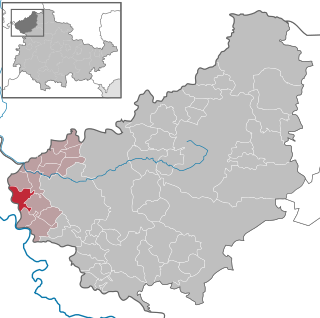
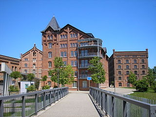
Gößnitz is a town in the Altenburger Land district, in Thuringia, Germany. It is situated on the river Pleiße, 12 km south of Altenburg, and 20 km northwest of Zwickau. Gößnitz received its town charter in 1718. It is known for the railroad junction of the Leipzig-Hof railway connection and the Central-Germany connection and its station prides itself having Europe's longest platform, as well as the Gößnitz Open-Air. The town's greatest prosperity was at the time of industrialization; Hence Viktor Grimm's representative malt factory from 1889 still characterizes the cityscape.

Kahla is a town in the Saale-Holzland district, in Thuringia, Germany. It is situated on the river Saale, 14 km south of Jena.

Kaltennordheim is a town in the Schmalkalden-Meiningen district, in Thuringia, Germany. It is situated in the Rhön Mountains, 22 km southwest of Bad Salzungen, and 35 km east of Fulda. The former municipalities Aschenhausen, Kaltensundheim, Kaltenwestheim, Melpers, Oberkatz und Unterweid were merged into Kaltennordheim in January 2019. At the same time, Kaltennordheim passed from the Wartburgkreis to Schmalkalden-Meiningen.

Neuhaus am Rennweg is a town in the district of Sonneberg, in Thuringia, Germany. It is situated in the Thuringian Forest, 17 km north of Sonneberg, and 22 km southwest of Saalfeld. The former municipalities Lichte and Piesau were merged into Neuhaus am Rennweg in January 2019.

Rastenberg is a town in the district of Sömmerda, in Thuringia, Germany. It is situated 22 km east of Sömmerda, and 23 km northeast of Weimar.

Römhild is a town in the district of Hildburghausen, in Thuringia, Germany. It is situated 14 km west of Hildburghausen, and 21 km southeast of Meiningen. On 31 December 2012, it merged with the former municipalities Gleichamberg, Haina, Mendhausen, Milz and Westenfeld.

Ronneburg is a town in the district of Greiz, in Thuringia, Germany. It is situated 7 km east of Gera.
Schkölen is a town in the Saale-Holzland district, in Thuringia, Germany. It is situated 12 km south of Naumburg. The village Zschorgula is part of the municipality.

Vacha is a town in the Wartburgkreis district, in Thuringia, Germany. It is situated on the river Werra, 15 km west of Bad Salzungen, and 23 km east of Bad Hersfeld.
Großlohra is a municipality in the district of Nordhausen, in Thuringia, Germany, situated on the northern edge of the Hainleite ridge about 20 km (12 mi) southwest of the district capital. It consists of the settlements of Friedrichslohra, Großwenden, Kleinwenden, as well as Münchenlohra with its former convent basilica St. Gangulphus and castle Lohra with its accompanying manor, all of which were united in 1950.
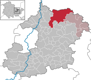
Ilm-Kreis II is an electoral constituency represented in the Landtag of Thuringia. It elects one member via first-past-the-post voting. Under the current constituency numbering system, it is designated as constituency 23. It covers the northern and western part of Ilm-Kreis.
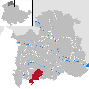
Saale-Orla-Kreis I is an electoral constituency represented in the Landtag of Thuringia. It elects one member via first-past-the-post voting. Under the current constituency numbering system, it is designated as constituency 33. It covers the southern part of Saale-Orla-Kreis.