Schleiz

Last updated

Schleiz
Stadtkirche Schleiz.JPG
Church in Schleiz
Wappen Schleiz.png
Location of Schleiz within Saale-Orla-Kreis district
Schleiz in SOK.pngGerodaKeilaHirschbergMoxaPaskaSchöndorfTannaWilhelmsdorf
Germany adm location map.svg
Red pog.svg
Schleiz
Thuringia location map.svg
Red pog.svg
Schleiz
Coordinates: 50°35′N11°49′E / 50.583°N 11.817°E / 50.583; 11.817
Country Germany
State Thuringia
District Saale-Orla-Kreis
Subdivisions15
Government
   Mayor (201824) Marko Bias [1] (CDU)
Area
  Total108.22 km2 (41.78 sq mi)
Elevation
432 m (1,417 ft)
Population
 (2021-12-31) [2]
  Total8,800
  Density81/km2 (210/sq mi)
Time zone UTC+01:00 (CET)
  Summer (DST) UTC+02:00 (CEST)
Postal codes
07901–07907
Dialling codes 03663
Vehicle registration SOK
Website www.schleiz.de
Postcard picture of Schleiz in 1908 Postkarte Schleiz 1908.jpg
Postcard picture of Schleiz in 1908
Former mint building (called "Alte Munze"-"Old Mint") Schleiz Alte Muenze.jpg
Former mint building (called "Alte Münze"-"Old Mint")
Dragon fountain Schleiz Drachenbrunnen.jpg
Dragon fountain

Schleiz is a town in the district of Saale-Orla-Kreis in Thuringia, Germany. The former municipality Crispendorf was merged into Schleiz in January 2019, and Burgk in December 2019.

Contents

Location

Schleiz is in the Thuringian Vogtland area, an area of wooded hills on the borders of Thuringia, Saxony, Bavaria and the Czech Republic. The city is located in a valley with the river Wisenta near the motorway A 9 (BerlinMünchen).

Neighboring parishes

Crispendorf (6 km) Görkwitz (2 km) Oettersdorf (3 km) Löhma (5 km) Kirschkau (6 km) Zeulenroda-Triebes (14 km)
Remptendorf (12 km) Windrose klein.svg Pausa (13 km)
Saalburg-Ebersdorf (12 km) Tanna (10 km) Mühltroff (9 km)

Distances calculated as between town centers.

Subdivisions

Schleiz includes the following subdivisions:

History

Schleiz can be traced back to a settlement established about 1200 ("Altstadt") and a separate "Neustadt" that was established next to it. The "Neustadt" had a castle and a city wall. Until 2 December 1482 they were totally separate communities after which they combined to one city.[ citation needed ] There was a settlement of the Teutonic Order here, and for some years previous to 1848 the town was the capital of the small principality of Reuss-Schleiz. In the vicinity a battle was fought, between the French and the Prussians on 9 October 1806. [3]

Within the German Empire (1871-1918), Schleiz was part of the Principality of Reuss-Gera.

20th Century

During World War II hundreds of women and men from several nations, including the Soviet Union were transported to Schleiz as forced laborers. At least 60 of them died there.

The palace was destroyed April 1945. [4]

Climate

Climate data for Schleiz (1991–2020 normals)
MonthJanFebMarAprMayJunJulAugSepOctNovDecYear
Average high °C (°F)1.6
(34.9)
3.2
(37.8)
7.2
(45.0)
12.9
(55.2)
16.7
(62.1)
20.5
(68.9)
23.0
(73.4)
22.5
(72.5)
17.7
(63.9)
12.3
(54.1)
6.1
(43.0)
2.8
(37.0)
12.2
(54.0)
Daily mean °C (°F)−0.7
(30.7)
0.2
(32.4)
3.4
(38.1)
8.0
(46.4)
12.0
(53.6)
15.4
(59.7)
17.6
(63.7)
17.4
(63.3)
13.2
(55.8)
8.6
(47.5)
3.5
(38.3)
0.8
(33.4)
8.4
(47.1)
Average low °C (°F)−3.1
(26.4)
−2.6
(27.3)
−0.1
(31.8)
3.1
(37.6)
6.8
(44.2)
10.5
(50.9)
12.5
(54.5)
12.2
(54.0)
9.0
(48.2)
5.4
(41.7)
1.2
(34.2)
−1.6
(29.1)
4.4
(39.9)
Average precipitation mm (inches)32.9
(1.30)
30.0
(1.18)
40.0
(1.57)
39.4
(1.55)
64.6
(2.54)
73.7
(2.90)
89.9
(3.54)
72.3
(2.85)
58.2
(2.29)
46.0
(1.81)
43.0
(1.69)
43.0
(1.69)
649.8
(25.58)
Average precipitation days (≥ 0.1 mm)16.915.217.113.314.814.215.214.312.714.314.918.0183.6
Average relative humidity (%)87.483.279.372.072.673.571.971.777.784.489.288.579.3
Mean monthly sunshine hours 57.478.1121.2180.8205.6205.0219.6210.4160.6110.158.547.91,673.8
Source: World Meteorological Organization [5]

Population

Trend of population figures:

1834 — 1995

  • 1834 - 4619
  • 1890 - 4928
  • 1933 - 6505
  • 1939 - 6828
  • 1960 - 7933 [6]
  • 1994 - 8567 [7]
  • 1995 - 9163

1996 — 2002

  • 1996 - 9528
  • 1997 - 9375
  • 1998 - 9389
  • 1999 - 9336
  • 2000 - 9309
  • 2001 - 9268
  • 2002 - 9223

2003 — 2009

  • 2003 - 9100
  • 2004 - 9069
  • 2005 - 9012
  • 2006 - 8932
  • 2007 - 8868
  • 2008 - 8824
  • 2009 - 8717

Recreation

Schleiz is also the site of the Schleizer Triangle motor racing track.

Commemorative plaque for Johann Friedrich Bottger Schleiz Boettger plaque.jpg
Commemorative plaque for Johann Friedrich Böttger

Notable people

Related Research Articles

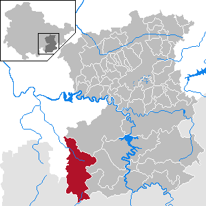
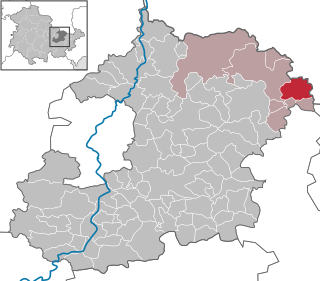
Greiz is a Kreis (district) in the east of Thuringia, Germany. Neighboring districts are Saale-Holzland, Saale-Orla, district-free city Gera, the Burgenlandkreis in Saxony-Anhalt, Altenburger Land, and the two Saxon districts Zwickau and Vogtlandkreis.

Saale-Orla is a Kreis (district) in the east of Thuringia, Germany. Neighboring districts are the districts Saale-Holzland, Greiz, the Vogtlandkreis in Saxony, the Bavarian districts Hof and Kronach, and the district Saalfeld-Rudolstadt.

<span class="mw-page-title-main">Zeulenroda-Triebes</span> Town in Thuringia, Germany

Zeulenroda-Triebes is a German town in the district of Greiz in the state of Thuringia.

<span class="mw-page-title-main">Neundorf bei Schleiz</span> Municipality in Thuringia, Germany

Neundorf (bei Schleiz) is a municipality in the district of Saale-Orla, Thuringia, Germany.

<span class="mw-page-title-main">Greiz</span> Town in Thuringia, Germany

Greiz is a town in the state of Thuringia, Germany, and is the capital of the district of Greiz. Greiz is situated in eastern Thuringia, 100 kilometres (62 mi) east of state capital Erfurt, on the river White Elster.

<span class="mw-page-title-main">Hilbersdorf</span> Municipality in Thuringia, Germany

Hilbersdorf is a German municipality in the Thuringian district of Greiz. It belongs to the Verwaltungsgemeinschaft of Wünschendorf/Elster and lies in upper Wipsetal.

<span class="mw-page-title-main">Tanna, Germany</span> Town in Thuringia, Germany

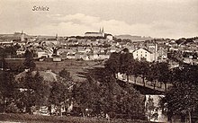
Tanna is a city in Thuringia, in the district of Saale-Orla-Kreis. It is located about 10 km south of Schleiz. Tanna was founded in 1495. The musicologist Paul Willert (1901–1988) was born in the city.

<span class="mw-page-title-main">Bad Köstritz</span> Town in Thuringia, Germany

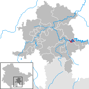
Bad Köstritz is a town in the district of Greiz, in Thuringia, Germany. It is situated on the White Elster river, 7 km northwest of Gera. Bad Köstritz is known for the Köstritzer brewery and its Schwarzbier.

<span class="mw-page-title-main">Gefell</span> Town in Thuringia, Germany

Gefell is a town in the Saale-Orla-Kreis district, in Thuringia, Germany.

<span class="mw-page-title-main">Großbreitenbach</span> Town in Thuringia, Germany

Großbreitenbach is a town in the Ilm-Kreis district, in Thuringia, Germany. It is situated 13 km southeast of Ilmenau. It has about 8000 inhabitants. Major industries are glass manufacturing and tourism. The former municipalities Altenfeld, Böhlen, Friedersdorf, Gillersdorf, Herschdorf, Neustadt am Rennsteig and Wildenspring were merged into Großbreitenbach in January 2019.

<span class="mw-page-title-main">Hirschberg, Thuringia</span> Town in Thuringia, Germany

Hirschberg is a town in the Saale-Orla-Kreis district, in Thuringia, Germany. It is situated on the river Saale, 20 km south of Schleiz, 12 km northwest of Hof (Bavaria), and 25 km southwest of Plauen (Saxony).

<span class="mw-page-title-main">Hohenleuben</span> Town in Thuringia, Germany

Hohenleuben is a town in the district of Greiz, in Thuringia, Germany. It is situated 12 km northwest of Greiz, and 19 km south of Gera.

<span class="mw-page-title-main">Neustadt an der Orla</span> Town in Thuringia, Germany

Neustadt an der Orla is a town in Saale-Orla-Kreis district, in Thuringia. It is situated at the small river Orla, 17 km north of Schleiz, and 25 km southeast of Jena. The former municipality Stanau was merged into Neustadt an der Orla in January 2019, and Linda bei Neustadt an der Orla, Knau and Dreba in December 2019.

<span class="mw-page-title-main">Saalburg-Ebersdorf</span> Town in Thuringia, Germany

Saalburg-Ebersdorf is a town in the Saale-Orla-Kreis district, in Thuringia, Germany close to the Bavarian border. It is situated on the river Saale, 10 km southwest of Schleiz, 30 km west of Plauen and 30 km north-west of Hof.

<span class="mw-page-title-main">Wurzbach</span> Town in Thuringia, Germany

Wurzbach is a town in the Saale-Orla-Kreis district, in southern Thuringia, Germany. It is situated 33 kilometres (21 mi) southeast of Saalfeld, and 45 kilometres (28 mi) northwest of Hof.

<span class="mw-page-title-main">Stadtilm</span> Town in Thuringia, Germany

Stadtilm is a town in the Ilm-Kreis district, in Thuringia, Germany. It is situated on the river Ilm, 15 km northeast of Ilmenau, and 11 km southeast of Arnstadt. In July 2018 the former municipality of Ilmtal was merged into Stadtilm.

<span class="mw-page-title-main">Langenwetzendorf</span> Municipality in Thuringia, Germany

Langenwetzendorf is a municipality in the district of Greiz, in Thuringia, Germany.

<span class="mw-page-title-main">Lausnitz</span> Municipality in Thuringia, Germany

Lausnitz is a municipality in the district Saale-Orla-Kreis, in Thuringia, Germany. It lies 4 km west of Neustadt an der Orla.

<span class="mw-page-title-main">Hohenwarte</span> Municipality in Thuringia, Germany

Hohenwarte is a municipality in the district Saalfeld-Rudolstadt, in Thuringia, Germany.

<span class="mw-page-title-main">Heinrich Gottfried Piegler</span> German entrepreneur and manufacturer

Heinrich Gottfried Piegler was a German entrepreneur and manufacturer who produced the first "modern" lighters which delivered a flame at the pressure of a lever, the so-called Döbereiner lighters, in large quantities in Schleiz and sold them worldwide.

References

  1. Gewählte Bürgermeister - aktuelle Landesübersicht, Freistaat Thüringen, accessed 14 July 2021.
  2. "Bevölkerung der Gemeinden, erfüllenden Gemeinden und Verwaltungsgemeinschaften in Thüringen Gebietsstand: 31.12.2021" (in German). Thüringer Landesamt für Statistik. June 2022.
  3. Chisholm 1911, p. 334.
  4. Klimpke, Juergen (2005). Als der Tod vom Himmel fiel. Der 8. April 1945. Schleizer Heimathefte. Vol. 38. Schleiz: Klimpke. p. 26.
  5. "World Meteorological Organization Climate Normals for 1991–2020". World Meteorological Organization Climatological Standard Normals (1991–2020). National Oceanic and Atmospheric Administration. Archived from the original on 12 October 2023. Retrieved 13 October 2023.
  6. from 1960 on always as of 31 December
  7. Source from 1994 onwards: Thüringer Landesamt für Statistik
Attribution