Bad Lobenstein

Last updated

Bad Lobenstein
Altstadt Bad Lobenstein.JPG
Old town of Bad Lobenstein
Wappen Bad Lobenstein.svg
Location of Bad Lobenstein within Saale-Orla-Kreis district
Bad Lobenstein in SOK.pngGerodaKeilaHirschbergMoxaPaskaSchöndorfTannaWilhelmsdorf
Germany adm location map.svg
Red pog.svg
Bad Lobenstein
Thuringia location map.svg
Red pog.svg
Bad Lobenstein
Coordinates: 50°27′N11°39′E / 50.450°N 11.650°E / 50.450; 11.650
Country Germany
State Thuringia
District Saale-Orla-Kreis
Subdivisions6 Ortsteile
Government
   Mayor (201824) Thomas Weigelt [1] (Ind.)
Area
  Total48.94 km2 (18.90 sq mi)
Elevation
560 m (1,840 ft)
Population
 (2022-12-31) [2]
  Total5,733
  Density120/km2 (300/sq mi)
Time zone UTC+01:00 (CET)
  Summer (DST) UTC+02:00 (CEST)
Postal codes
07351–07356
Dialling codes 036651
Vehicle registration SOK
Website www.moorbad-lobenstein.de
Bad Lobenstein - downtown area with church Bad Lobenstein-Innenstadtpanorama.jpg
Bad Lobenstein - downtown area with church

Bad Lobenstein is a spa town in the Saale-Orla-Kreis district, in Thuringia, Germany with a population of about 6,000 inhabitants. Until 2005, the town was named Lobenstein.

Contents

The town, grouped round a rock, upon which stand the ruins of an old castle, is exceedingly picturesque. It contains a spacious parish church, a palace (until 1824 the residence of the princes of Reuss-Lobenstein-Ebersdorf), and a hydropathic establishment. Local industries include dyeing, brewing and cigar-making. [3]

Geography

The town is located in the Thuringian Highlands between Thuringian Forest and Franconian Forest, south-westerly of the large Saale river dams at Hohenwarte and Bleiloch near Gräfenwarth.

History

The high medieval castle of Lobenstein lies above the center of the town on the right side of the river Lemnitz on a mountain dome. It was used to monitor traffic on the route from Leipzig to Bamberg. Lobenstein was first mentioned in 1250 as the seat of a knight. It was probably a foundation of the Lords of Lobdeburg. An Otto von Lobenstein was mentioned in 1250 at the castle, the first written mention of Lobenstein. In the 13th century, the fortress belonged to the vogts of Gera. From 1597 until 1601 it was the residence of the junior line of the House of Reuss. By 1600 the castle had greatly decayed, and the Reuss then moved to the palace. During the Thirty Years War the castle played a small role, when, in 1632, imperial troops stormed the fortress then occupied by Sweden. Today only the remains of the keep and the fortification wall announce the presence of the castle. [4]

Lobenstein was called already a city by 1278. A Mayor and Council are mentioned in 1411, serving as the lower courts.

On October 8, 1806, the army of Napoleon marched through the city. At 9:00 o'clock Emperor Napoleon I. left Kronach in Bavaria, where he had he visited the fortress and strengthened it with its own and allied Bavarian troops to have a retreat in case of defeat by Prussia. He arrived in Lobenstein around 12:30. His way led over the Gallenberg to Ebersdorf, where he spent the night with 32 generals and staff officers. Day and night Around 190,000 men marched through Lobenstein. The city and the surrounding area were affected. Bivouac and looting were the order of the day. Despite their neutrality the population suffered greatly.

In the new palace was the Marshal and later King of Norway-Sweden Bernadotte. On October 14 the Battle of Jena–Auerstedt was fought, sealing the fate of Prussia.

A citizen of Lobenstein, town clerk Christian Gottlieb Reichard, was known as far as Paris for his extraordinary geographic knowledge. Napoleon invited him to accompany the army as a cartographer. Reichard refused, citing his health, and took to his bed; it is not known Whether he was really ill. From 1597 to 1918, the city belonged to the junior line of the House of Reuss, where, in 1824, it was the residence of the sub-line Reuss-Lobenstein and from then to 1848 to the line Ebersdorf. In 1848, together with Schleiz and Hirschberg, it formed a center of the bourgeois movement.

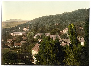
In 1862 almost all historic buildings were destroyed in a fire. From 1868, healing earth extracted from the nearby high moor and an iron mineral spring brought about the development of a spa in Lobenstein. [5]

The city got railway connections in 1896 to Triptis, in 1901 to Hof, and 1907 to Saalfeld.

During the Second World War 60 women and men from Eastern Europe who were housed in two "Eastern Labor Camps" (Ostarbeiterlagern) had to do forced labor in the metal works of Werner Schröder, in the sawmill, and in the railway maintenance works. In the cemetery of Lobenstein a wooden cross commemorates a concentration camp prisoner who was shot dead by SS men during a death march on the Gallenberg. In the spa park, a memorial with a sculpture "Mourning Mother" by a Polish artist commemorates all victims of fascism of Bad Lobenstein. [6]

Since March 21, 2005, the city officially bears the name "Bad Lobenstein", making it the twelfth spa town in Thuringia. Lobenstein had previously fought for decades for the title of "Bad" ("Spa").

On December 7, 2022, Bad Lobenstein hit the headlines, when the Jagdschloss Waidmannsheil  [ de ] – like other places in eleven German federal states, Italy and Austria – became the scene of one of the largest anti-terror operations in the history of the Federal Republic. In the course of the major raid against the right-wing terrorist network Patriotic Union around Heinrich XIII Prinz Reuss, who is accused by the Public Prosecutor General of Germany of preparing a coup in Germany, the castle was searched. [7]

Coat of arms

Blazon: "In red floating the silver-black divided trunk of a bracke"

The trunk of the bracke (a certain type of dog group) is the crest of Principality of Reuss-Greiz (German: Fürstentum Reuß-Greiz). The image was already used in 15th century as coat of arms for the town.

Etymology

Lobenstein could come from "Lobe den Stein" which means "Praise the stone".

A legend describes how the inhabitants believe the town's name might have been established. It is believed that emperor Ludwig the Bavarian, who lived from 1328 to 1347 announced "Praise the stone" as he had lost and found his favourite dog in this region during hunting for deer. He was looking for the dog for quite a while until finally one of his knights found the tired and slightly injured dog lying on a stone. The knight carried the dog to his master, who was so grateful, he gave this piece of land as fief to the knight. In memory of this event, the place received the name Lobenstein and carried from now on the head of a bracke in its coat of arms. [8]
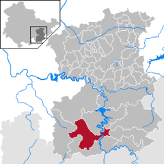
Districts

Neighbouring communities

Incorporating communities

On 4 August 1993 previously independent municipalities Helmsgrün and Lichtenbrunn got incorporated into the community of Bad Lobenstein. [9] On 1 January 1997 also Unterlemnitz and in 1999 Oberlemnitz got in incorporated. [10]

Population growth

Demographic development (from 1994 on each number was counted on 31 December):

  • 1833: 3.274
  • 1933: 3.391
  • 1939: 3.577
  • 1994: 7.002
  • 1995: 7.019
  • 1996: 7.083
  • 1997: 7.455
  • 1998: 7.419
  • 1999: 7.363
  • 2000: 7.332
  • 2001: 7.235
  • 2002: 7.132
  • 2003: 7.042
  • 2004: 6.948
  • 2005: 6.905
  • 2006: 6.820
  • 2007: 6.653
  • 2008: 6.570
  • 2009: 6.466
  • 2010: 6.444
  • 2011: 6.236
  • 2012: 6.164
  • 2013: 6.108
  • 2014: 6.073
  • 2015: 6.146

Data source from 1994: Thuringian State office for Statistics

City park, former palace garden Bad Lobenstein-Pavillon.jpg
City park, former palace garden
Market place of Bad Lobenstein Bad Lobenstein-Markt1.jpg
Market place of Bad Lobenstein

Sights of Bad Lobenstein

Ruins of Lobenstein Castle Turm BadLobenstein.jpg
Ruins of Lobenstein Castle
The "Fasslesacher" in the town hall tower Lobenstein Fassleseecher.jpg
The "Fäßlesächer" in the town hall tower

Notable residents

Sons and daughters of the town

Anton Friedrich Hohl Anton Friedrich Hohl.jpg
Anton Friedrich Hohl

Other personalities

Related Research Articles

<span class="mw-page-title-main">Imperial County of Reuss</span> Principality within the Holy Roman Empire (c. 1010 - 1778/1806)

Reuss was the name of several historical states located in present-day Thuringia, Germany. Several lordships of the Holy Roman Empire which arose after 1300 and became Imperial Counties from 1673 and Imperial Principalities in the late 18th century were ruled by the House of Reuss.

<span class="mw-page-title-main">Gera</span> City in Thuringia, Germany

Gera is a city in the German state of Thuringia. With around 93,000 inhabitants, it is the third-largest city in Thuringia after Erfurt and Jena as well as the easternmost city of the Thüringer Städtekette, an almost straight string of cities consisting of the six largest Thuringian cities from Eisenach in the west, via Gotha, Erfurt, Weimar and Jena to Gera in the east. Gera is the largest city in the Vogtland, and one of its historical capitals along with Plauen, Greiz and Weida. The city lies in the East Thuringian Hill Country, in the wide valley of the White Elster, between Greiz (upstream) and Leipzig (downstream). Gera is located in the Central German Metropolitan Region, approximately 60 kilometres south of Saxony's largest city of Leipzig, 80 km east of Thuringia's capital Erfurt, 120 km west of Saxony's capital Dresden and 90 km north of Bavaria's city of Hof (Saale).

Greiz is a Kreis (district) in the east of Thuringia, Germany. Neighboring districts are Saale-Holzland, Saale-Orla, district-free city Gera, the Burgenlandkreis in Saxony-Anhalt, Altenburger Land, and the two Saxon districts Zwickau and Vogtlandkreis.

Wartburgkreis is a Kreis (district) in the west of Thuringia, Germany. Neighboring districts are the districts Unstrut-Hainich-Kreis, Gotha, Schmalkalden-Meiningen, and the districts Fulda, Hersfeld-Rotenburg and Werra-Meißner-Kreis in Hesse.

<span class="mw-page-title-main">Bad Blankenburg</span> Town in Thuringia, Germany

Bad Blankenburg is a spa town in the district of Saalfeld-Rudolstadt, in Thuringia, Germany. It is situated 6 km southwest of Rudolstadt, and 37 km southeast of Erfurt. It is most famous for being the location of the first kindergarten of Friedrich Wilhelm August Fröbel, in 1837.

<span class="mw-page-title-main">Hildburghausen</span> Town in Thuringia, Germany

Hildburghausen is a town in Thuringia in central Germany, capital of the Hildburghausen district.

<span class="mw-page-title-main">Waltershausen</span> Town in Thuringia, Germany

Waltershausen is a town in the south-western part of the district of Gotha in the state of Thuringia, Germany.

<span class="mw-page-title-main">Altenstein Palace</span> Schloss (palace) upon a rocky hill on the south-western slope of the Thuringian Forest

Schloss Altenstein is a schloss, or palace, upon a rocky hill on the south-western slope of the Thuringian Forest, not far from Eisenach, Thuringia, Germany. It was the summer residence of the Dukes of Saxe-Meiningen, and is surrounded by 160 hectares of English landscape garden, which contain, among other objects of interest, a cavern 300 metres long, through which flows a large and rapid stream.

<span class="mw-page-title-main">Rudolstadt</span> Town in Thuringia, Germany

Rudolstadt is a town in the German federal state Thuringia, within the Thuringian Forest, to the southwest, and to Jena and Weimar to the north.

<span class="mw-page-title-main">Schleiz</span> Town in Thuringia, Germany

Schleiz is a town in the district of Saale-Orla-Kreis in Thuringia, Germany. The former municipality Crispendorf was merged into Schleiz in January 2019, and Burgk in December 2019.

<span class="mw-page-title-main">Bad Köstritz</span> Town in Thuringia, Germany

Bad Köstritz is a town in the district of Greiz, in Thuringia, Germany. It is situated on the White Elster river, 7 km northwest of Gera. Bad Köstritz is known for the Köstritzer brewery and its Schwarzbier.

<span class="mw-page-title-main">Bad Liebenstein</span> Town in Thuringia, Germany

Bad Liebenstein is a municipality and spa town in Wartburgkreis district of Thuringia, Germany.

<span class="mw-page-title-main">Saalburg-Ebersdorf</span> Town in Thuringia, Germany

Saalburg-Ebersdorf is a town in the Saale-Orla-Kreis district, in Thuringia, Germany close to the Bavarian border. It is situated on the river Saale, 10 km southwest of Schleiz, 30 km west of Plauen and 30 km north-west of Hof.

<span class="mw-page-title-main">Großenstein</span> Municipality in Thuringia, Germany

Großenstein is a municipality in the district of Greiz, in Thuringia, Germany. The town is member of the municipal association Am Brahmetal.

<span class="mw-page-title-main">Schwaara</span> Municipality in Thuringia, Germany

Schwaara is a municipality in the district of Greiz, in Thuringia, Germany. The town is member of the municipal association Am Brahmetal.

<span class="mw-page-title-main">Crossen an der Elster</span> Municipality in Thuringia, Germany

Crossen an der Elster is a village and municipality in the district Saale-Holzland, in Thuringia, Germany. The White_Elster is the name of the small river which flows through the municipality, so 'Crossen on the Elster' would be the English equivalent.

<span class="mw-page-title-main">Triptis–Marxgrün railway</span>

The Triptis–Marxgrün railway is a branch line in Germany that runs through the states of Thuringia and Bavaria, and which was originally built and operated by the Prussian state railways. It ran from Triptis via Ziegenrück, Bad Lobenstein and Blankenstein to Marxgrün. The only section still in service today is the stretch of line between Ebersdorf-Friesau and Blankenstein. The Thuringian section is also called the Oberlandbahn ; the Bavarian section the Höllentalbahn.

Heinrich X, Count of Reuss-Ebersdorf, was a member of the House of Reuss. He was Count of Lobenstein, and from 1678, Count of Ebersdorf. He was the founder of Reuss-Ebersdorf line.

<span class="mw-page-title-main">Heinrich XIII Prinz Reuss</span> German real estate developer and alleged coup plotter (born 1951)

Heinrich XIII Prinz Reuss is a German businessman, far-right and monarchist activist, and member of the aristocratic House of Reuss family. A proponent of the Reichsbürger movement and antisemitic conspiracy theories, Reuss was arrested by German Federal Police in December 2022 due to his alleged leadership in the 2022 German coup d'état plot.

Heinrich Reuss is the name of many male members of the German noble House of Reuss. It may refer to:

References

  1. Gewählte Bürgermeister - aktuelle Landesübersicht, Freistaat Thüringen, accessed 14 July 2021.
  2. "Bevölkerung der Gemeinden, erfüllenden Gemeinden und Verwaltungsgemeinschaften in Thüringen Gebietsstand: 31.12.2022" (in German). Thüringer Landesamt für Statistik. June 2023.
  3. Wikisource-logo.svg One or more of the preceding sentences incorporates text from a publication now in the public domain :  Chisholm, Hugh, ed. (1911). "Lobenstein". Encyclopædia Britannica . Vol. 16 (11th ed.). Cambridge University Press. p. 837.
  4. Thomas Bienert: Mittelalterliche Burgen in Thüringen. 430 Burgen, Burgruinen und Burgstätten. Wartberg-Verlag, Gudensberg-Gleichen 2000, ISBN   3-86134-631-1, S. 216.
  5. Moorbad Lobenstein. In: Hans Joachim Kessler: Heilendes Wasser und sprudelnde Quellen. Begegnung mit historischen Bädern in Thüringen. Reinhold, Altenburg 2001, ISBN   3-910166-44-X, S. 84–87.
  6. Thüringer Verband der Verfolgten des Naziregimes – Bund der Antifaschisten und Studienkreis deutscher Widerstand 1933–1945 (Hrsg.): Heimatgeschichtlicher Wegweiser zu Stätten des Widerstandes und der Verfolgung 1933–1945. Band 8: Thüringen. VAS – Verlag für Akademische Schriften, Frankfurt am Main 2003, ISBN   3-88864-343-0, 223 ff.
  7. Christian Unger and Peter Hagen (7 December 2022). "Reichsbürger-Razzia: Warum Prinz Heinrich XIII. im Visier der Anti-Terror-Ermittler ist" (in German). Berliner Morgenpost . Retrieved 10 March 2024.
  8. Arbeitsgemeinschaft Thüringen e.V. (Hrsg.): Neues Thüringer Wappenbuch. Band 2. Seite 39, 1998, ISBN   3-9804487-2-X
  9. Gemeinden 1994 und ihre Veränderungen seit 01.01.1948 in den neuen Ländern, Verlag Metzler-Poeschel, Stuttgart, 1995, ISBN   3-8246-0321-7, Herausgeber: Statistisches Bundesamt
  10. "Regionales". Statistisches Bundesamt.