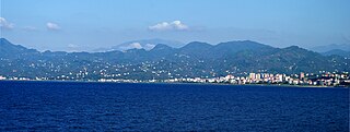
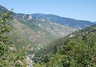
In the west its shorter arm originates from Çekümbeli highland near Tohumluk village. Its longer arm starts in Tekçam-Kürünbeli spring in Hanzara Obası and Ayıbeli Deresi in Ayıbeli Obası. The springs of its arms are close enough to each other to be reached in less than an hour by foot. The source of the longer arm looks like a triangular area which is used as the borders of three districts: Espiye, Alucra and Torul. Firstly it goes to northeast direction passing through Beytarla and Sapmaz villages of Kürtün district of Gümüşhane province, then enters into Giresun borders again. After the two arms of the stream flow parallel for nearly 40-50 kilometers they aggregate as Gelevara after Arpacık village in Güce district adjacent to Espiye district. Gelevara flows down to Black Sea in the east end of Espiye town like Yağlıdere stream, its sister. On its mouth to Black Sea there is a ferroconcrete bridge on D010 Highway connecting Giresun and Trabzon provinces.
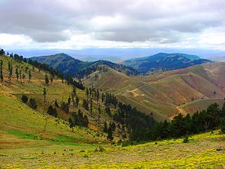
Gelevara stream has a high voluminous flow because the mountainous and forestry area of its headwaters and because it receives much rain during almost all seasons. The stream is mainly utilized as a sands deposit in building concrete constructions locally. In its valley along the Espiye-Ericek-Çakıl route, there are hills covered by rich forests consisting of thousands of species of wild trees, flowers and animals.
Etymology
"Gelevara" (pronounced as ghe-lee-va-ra) is a Turkish derivative word consists of two verbs, "gelmek (to come in English)" and "varmak (to arrive in English"). It is officially and mostly called as Gelevera Deresi in Turkish maps and documentaries there are some other local forms of its name like Özlüce, and some forms of folk dialects such as Gelivera, Gelivar, Gelevera, Gelevar, Gelava, and Gelenvar.
Although Dr. Z. Cebeci interprets that it carries a meaning like "come and arrive in the sea" that was used by local people living in mountainous area in order to express their deep wishes to see beauties of the sea there are two other logical hypothesis about the origin of Gelevera.
In the article titled "Gelivera, Kürtün" in Turkish Wikipedia, it is supposed that its name originates from "Gelivera", an old Greek village settlement (Sapmaz in present time) in Kürtün district of Gümüşhane. In this article it is stated that "gelivera" is a joint word formed with "gali" and "vera" meaning "beautiful" and "ring" in modern Greek, respectively. According to the second hypothesis its name originates from daily movements of villagers on it. Since the longer arm of the stream passes through "Gelivera" village the inhabitants had frequently to go and come back between two parts of the village over it. Every day they were going and coming back between the sides of the stream. And then they defined the stream as the waterflow that must be stepped to go and come back. So in order to define their routinely go-come movement they used "gel" and "var" verbs of Turkish, and its name became "Gelevara" in the time.
Issues with Gelevara
The stream is being polluted with solid wastes of Espiye town. This serious environmental problem should be immediately solved with aid of some protection projects which will be operated by the Espiye Municipality. But any project needs the aid from international environmental organizations because the cost of recycling daily wastes of the town exceeds the income of the town municipality. At the same time the sand processing and excavations from the bed of the stream create sound pollution that fears the waterbirds and causes many other ecological problems. The existing freshwater flora and fauna is danger of extinction in the bed of the stream near Black Sea day to day. Also the sand excavation must be stopped to prevent the changes of natural scene and structure of the stream.
Gelevara Song
Gelevara Deresi is also the title of a famous Turkish folk song. This song carrying the typical characteristics of Black Sea variety of Turkic regional folks is about melancholic love story that has been lived somewhere along Gelevara stream valley. Originally it is performed with kemençe (kemenche in English, pronounced as kae-man-che), a local music instrument of Black Sea region of Turkey. This song with romantic notes about a dramatic love is recently remixed and performed by Kazım Koyuncu, and became more popular due to his duet with Şevval Sam. He performs the song on his album Hayde!.
Giresun Province is a province of Turkey on the Black Sea coast. Its adjacent provinces are Trabzon to the east, Gümüşhane to the southeast, Erzincan to the south, Sivas to the southwest, and Ordu to the west. Its license-plate code is 28.
Gümüşhane Province is a province in northern Turkey, bordering Bayburt to the east, Trabzon to the north, Giresun and Erzincan to the west. It covers an area of 6,575 km2 and has a population of 129,618 in 2010. The population was 186,953 in 2000. The name Gümüşhane means silver house. The city has a rich mining history and was the source of exports for Trabzon. The current Governor is Kamuran Taşbilek, he was appointed on the 27 October 2019.
Gümüşhane is a city in the Black Sea Region of Turkey. It is the seat of Gümüşhane Province and Gümüşhane District. Its population is 39,214 (2022). The city lies along the Harşit River, about 40 miles (64 km) southwest of Trabzon. The city lies at an elevation of 1,153 m (3,783 ft).
The Vilayet of Trebizond was a first-level administrative division (vilayet) in the north-eastern part of the Ottoman Empire, corresponding to the area along the eastern Black Sea coastline and the interior highland region of the Pontic Alps.
Doğankent is a town in Giresun Province in the Black Sea region of Turkey. It is the seat of Doğankent District. Its population is 4,545 (2022).
Espiye is a town in Giresun Province in the Black Sea region of Turkey. It is the seat of Espiye District. Its population is 26,671 (2022).
Kelkit is a town in Gümüşhane Province in the Black Sea region of Turkey. It is the seat of Kelkit District. Its population is 21,316 (2022). The town lies at an elevation of 1,375 m (4,511 ft).
Kürtün is a town in Gümüşhane Province in the Black Sea region of Turkey. It is the seat of Kürtün District. Its population is 4,329 (2022). The town lies at an elevation of 764 m (2,507 ft).
Torul is a town in Gümüşhane Province in the Black Sea Region of Turkey. It is the seat of Torul District. Its population is 5,794 (2022). The town lies at an elevation of 1,020 m (3,346 ft).
Yağlıdere is a stream that flows to the Black Sea in the west end of Espiye, the capital town of Espiye district in Giresun Province in Turkey.
Aksu is one of the main water streams of Giresun Province in the eastern Black Sea Region of Turkey. Its name is Turkish for "white water".
Karagöl is an area in Giresun Province in the Black Sea region of Turkey. Karagöl is the common name for a mountain chain, its summit, a lake on it, a high plateau around it and a summer settlement in the plateau located in the southeast of Dereli district. The plateau is located near the meeting point of the provincial boundaries of Giresun, Ordu and Sivas provinces.
Bektaş is a highland and settlement in Giresun Province of Turkey.
Aksu is a small village of Dereli District of the Giresun Province of Turkey. Its population is 169 (2022). It is located in the upper basin of the Aksu Deresi stream.
Karaca Cave is a network of caves located near the town of Torul in Gümüşhane Province, Turkey.
The Zigana Pass is a mountain pass situated on the Pontic Mountains in Gümüşhane Province close to its border with Trabzon Province in northeastern Turkey. The pass, at 2,032 m (6,667 ft) above sea level, is on the route D.885 E97 at a distance of 60 km (37 mi) from Gümüşhane and 120 km (75 mi) from Trabzon at the Black Sea coast. The pass is snow-covered five months a year.
The Harşit River is a river in the Black Sea Region of Turkey. It flows through the Gümüşhane and Giresun Provinces before its terminus in the Black Sea at Tirebolu. It is interrupted by the Torul and Kürtün Dams.
The Güvenlik Tunnel is a road tunnel constructed on the Tirebolu–Gümüşhane state highway D.877 in Giresun Province, northeastern Turkey. It was opened to traffic in 2008.
Kürtün District is a district of the Gümüşhane Province of Turkey. Its seat is the town of Kürtün. Its area is 917 km2, and its population is 11,913 (2022).
This page is based on this Wikipedia article Text is available under the CC BY-SA 4.0 license; additional terms may apply. Images, videos and audio are available under their respective licenses.