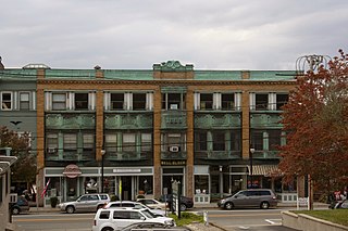
Wakefield is a village in the town of South Kingstown, Rhode Island, and the commercial center of the town. Together with the village of Peace Dale, it is treated by the U.S. Census as a component of the census-designated place identified as Wakefield-Peacedale, Rhode Island. West Kingston, another South Kingstown village, was the traditional county seat of Washington County. Since 1991, the Washington County Courthouse has been in Wakefield. The Sheriff's Office which handles corrections is also in Wakefield.

Peace Dale is a village in the town of South Kingstown, Rhode Island. Together with the village of Wakefield, it is treated by the U.S. Census as a component of the census-designated place identified as Wakefield-Peacedale, Rhode Island.
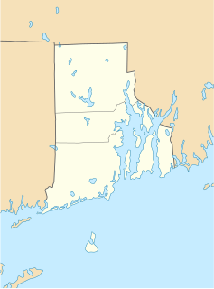
Kingston is a village and a census-designated place in the town of South Kingstown, Rhode Island, United States, and the site of the main campus of the University of Rhode Island. Much of the village center is listed on the National Register of Historic Places as Kingston Village Historic District.

Saunderstown is a small village and historic district in the towns of Narragansett and North Kingstown in Washington County, Rhode Island, United States.

The George Fayerweather Blacksmith Shop is an historic homestead and blacksmith shop at 1859 Mooresfield Road on the eastern outskirts of the Kingston Historic District in South Kingstown, Rhode Island. It was the home of George Fayerweather, an African-American blacksmith and his family, including his wife Sarah Harris Fayerweather. The shop was built in 1820 and was added to the National Register of Historic Places in 1984. The property is maintained by the Kingston Improvement Association, a non-profit organization of local residents, and is now the home of the Fayerweather Craft Guild and the Kingston Garden Club.

The Jireh Bull Blockhouse is an historic archaeological site on Middlebridge Road in South Kingstown, Rhode Island. In 1657 a blockhouse was built on the site by Jireh Bull, son of Rhode Island Governor Henry Bull. The stone garrison house was burned by the Native Americans in King Philip's War on December 15, 1675, and fifteen of its defenders were massacred. The site was acquired by the Rhode Island Historical Society in 1925.
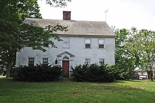
The Cottrell House is an historic complex at 500 Waites Corner Road in South Kingstown, Rhode Island. The house is the centerpiece of a working farm complex which includes 73 acres (30 ha) of land, and is one of South Kingstown's last working farms. The house, built c. 1790, is a fairly typical Federal style structure, 2-1/2 stories tall, five bays wide, with a large central chimney. The main barn, located south of the house, is believed to be contemporary to the house, although it has undergone some alteration and extension in the 20th century.

The Crowfield Historic District is a small residential historic district in North Kingstown, Rhode Island. It encompasses a cluster of four early 20th-century summer houses, all connected via family or friendship connections to the writer Owen Wister. The occupy a large parcel of land sloping down to the shore of Narragansett Bay on the east side of Boston Neck Road, a short way north of the Jamestown Verrazzano Bridge. The area was named "Crowfield" by Elizabeth Middleton Cope, who built a Shingle-style mansion in 1906. Owen Wister, her uncle, built his house, Champ de Corbeau, in 1909-10 to a design by Grant Lafarge. The Jamieson House was also built in 1906, and was designed by the same architect, James P. Jamieson. The fourth house, Orchard House, was built in 1924. All are Shingle style houses. The compound is unusual for North Kingstown, where most summer estates were isolated individual properties.

The Davisville Historic District is a historic district on Davisville Road in Davisville, Rhode Island, a village in North Kingstown. It encompasses the site of an early 19th-century mill, and several associated buildings, including five houses dating to the 18th or 19th century and a cemetery. It is located on either side of Davisville Road, between the Hunt River and Olde Mill Lane.

The Henry Eldred Farm is an historic farm complex at 368 Old North Road in South Kingstown, Rhode Island. The main block of the farmhouse, a 2-1/2 story wood frame structure, was probably built c. 1822, although there is architectural evidence suggesting it may be an enlargement of an older structure. Its simple Federal styling is distinctly rural and vernacular in character. The complex also includes a cluster of buildings dating to the mid-19th century, including a barn, carriage house, shed, and blacksmith shop.

The Ezekial Gardner House was an historic house at 297 Pendar Road in North Kingstown, Rhode Island. It was a 1-1/2 story wood frame house, with a gambrel roof. The oldest portion of the house dated to the early 18th century, and was the best-preserved of several period houses built by members of the locally prominent Gardner family. The house stood, along with an early 20th-century barn, at the end of a long tree-lined lane on the west side of Pendar Road.
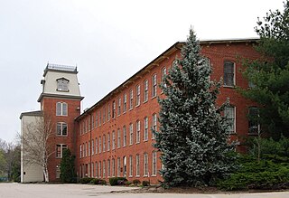
Lafayette Village is a historic district extending along Ten Rod Road in North Kingstown, Rhode Island. It encompasses a linear rural and industrial village, running from the Wickford Junction railroad crossing in the west to Angel Avenue in the east, and includes a number of residential properties on adjacent side streets. The centerpiece of the district is the Rodman Manufacturing Company complex, which operated here for a century beginning in the 1840s. The Robert Rodman Mansion, a Second Empire house with an elaborate porch, stands at 731 Ten Rod Road, and the Walter Rodman House, built in the 1870s, is even more elaborately decorated. Most of the residential stock in the district is mill-related housing built by the Rodmans for their workers.

The Palmer–Northrup House is an historic house at 7919 Post Road in North Kingstown, Rhode Island. It is a 2-1/2 story wood frame structure, and is one of a small number of surviving stone ender houses in the state. Its architecture suggests it was built in the 17th century, either around the time of King Philip's War (1675–78) or possibly even earlier. The oldest portion of the house, including its massive fieldstone chimney, are relatively intact despite later additions around 1740 that significantly enlarged the house. The house stands across the street from Smith's Castle, a house of similar vintage which was built on the site of a trading post established by Roger Williams in 1637.

The Joseph Pierce Farm is an historic farm at 933 Gilbert Stuart Road in North Kingstown, Rhode Island. It consists of 18 acres (7.3 ha) of land, along with an 18th-century farmhouse and a number of 19th-century outbuildings. The oldest portion of the house, its southern ell, was originally built with a gable roof, but this was extended to the north in the late 18th or early 19th century, and given it present gambrel roof and Federal styling. Later additions in the 19th and 20th centuries gave the house its present cruciform appearance. Outbuildings dating to the 19th century include a barn with attached privy, a toolshed, and a henhouse. The complex is a well-preserved reminder of the area's rural heritage.
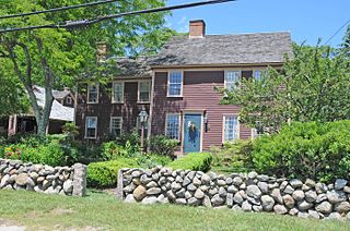
The Red House is an historic house at 2403 Post Road in South Kingstown, Rhode Island. The main block, a 2-1/2 story wood frame structure was probably built sometime in the early 18th century, and has long been a landmark in the Perryville village, receiving its name in the early 19th century. It is distinctive for period houses because of its asymmetrical facade, and was carefully restored in the late 1980s.

The Joseph Slocum House is an historic house on Slocum Road in North Kingstown, Rhode Island. It is a 1-1/2 story wood frame house, five bays wide, with a large central chimney. It faces south on the east side of Slocum Road. The house has been dated to the mid-18th century based on architectural evidence; its first documented owner was Joseph Slocum, in the early 19th century. The house is a rare surviving 18th-century farmhouse, a type once numerous in the town.

The Spink Farm is a historic farm at 1325 Shermantown Road in North Kingstown, Rhode Island. The only surviving element of the farmstead on this 55-acre (22 ha) farm is the main house, a 2-1/2 story five-bay wood frame structure built in 1798 by Isaac Spink. The house exhibits modest Federal styling, its doorway flanked by small sidelight windows and simple pilasters, and topped by a shallow hood. The interior follows a typical center-chimney plan, with its original Federal period fireplace mantels intact. The house has been extended to the rear by a kitchen ell and porch, both added in the 20th century. The house is one of a small number of 18th-century farmsteads left in the town.

The Tootell House is a house at 1747 Mooresfield Road in Kingston, Rhode Island that is listed on the National Register of Historic Places.

The former Washington County Courthouse is an historic building at 3481 Kingstown Road in South Kingstown, Rhode Island. Built in 1892, it was added to the National Register of Historic Places in 1992 as Washington County Court House.


