Geography of Rosario

Last updated

Location of Rosario within the province and the country. Rosario, Argentina - Situation map.png
Location of Rosario within the province and the country.

Rosario is the largest city of the province of Santa Fe , Argentina, and the third most populous in the country, after Córdoba and Buenos Aires. It is located about 300 km (190 mi) north of Buenos Aires, on the Western shore of the Paraná River, and it has about 910,000 inhabitants. It is surrounded by smaller cities and towns that form a metropolitan area (Greater Rosario) with a population of about 1.2 million according to the 2001 census [INDEC].

Contents

Geographic data

Rosario and the neighbouring areas along the Parana River from space. Note the Rosario-Victoria Bridge. ISD highres ISS001 ISS001-390-4.JPG
Rosario and the neighbouring areas along the Paraná River from space. Note the Rosario-Victoria Bridge.

The municipality of Rosario measures 178.69 square kilometres (68.99 sq mi) (not all of them are fully urbanized). Its extreme points are:

The geographical center is approximately at 32°57′2″S60°42′15″W / 32.95056°S 60.70417°W / -32.95056; -60.70417 .

The city is located on a smoothly undulated plain typical of the Pampas, between 22.5 and 24.6 metres above mean sea level; the original settlement rests on the ravine on the right-hand shore of the Paraná, opposite a group of islands of the Paraná Delta which are partly in the jurisdiction of the province of Entre Ríos. The nearest city across the river's flood plain (60 km) is Victoria, Entre Ríos, linked to Rosario by the Rosario-Victoria Bridge.

Climate and natural hazards

The Rosario area has a Pampean temperate climate. There is a hot season from November to March (with temperature extremes between 18 and 32  °C), and a cold season between June and mid-August (between 5 and 16 °C). Summer is rainier than winter. Local residents often complain about high levels of humidity throughout the year.

The last instance of snow was in the winter of 1973, being clearly an exceptional phenomenon (hail is not, though it is also quite rare).

Parts of the city are subject to flooding, but large events have historically been exceptional. The possibility of serious earthquakes is also remote, and other hazards such as hurricanes and volcanic eruptions are virtually impossible.

Climate data for Rosario – Islas Malvinas International Airport (1981–2010, extremes 1875–present)
MonthJanFebMarAprMayJunJulAugSepOctNovDecYear
Record high °C (°F)40.5
(104.9)
39.3
(102.7)
37.0
(98.6)
33.8
(92.8)
32.9
(91.2)
29.0
(84.2)
31.6
(88.9)
36.1
(97.0)
37.3
(99.1)
37.7
(99.9)
37.6
(99.7)
40.3
(104.5)
40.5
(104.9)
Average high °C (°F)30.8
(87.4)
29.2
(84.6)
27.4
(81.3)
23.5
(74.3)
19.9
(67.8)
16.6
(61.9)
16.2
(61.2)
18.9
(66.0)
20.9
(69.6)
24.2
(75.6)
27.1
(80.8)
29.6
(85.3)
23.7
(74.7)
Daily mean °C (°F)24.6
(76.3)
23.2
(73.8)
21.4
(70.5)
17.3
(63.1)
13.8
(56.8)
10.7
(51.3)
10.0
(50.0)
12.1
(53.8)
14.5
(58.1)
18.1
(64.6)
21.0
(69.8)
23.4
(74.1)
17.5
(63.5)
Average low °C (°F)18.4
(65.1)
17.5
(63.5)
16.0
(60.8)
12.1
(53.8)
8.7
(47.7)
6.0
(42.8)
4.8
(40.6)
6.2
(43.2)
8.3
(46.9)
12.0
(53.6)
14.7
(58.5)
17.2
(63.0)
11.8
(53.2)
Record low °C (°F)7.0
(44.6)
5.0
(41.0)
3.0
(37.4)
−0.9
(30.4)
−6.1
(21.0)
−7.8
(18.0)
−6.9
(19.6)
−7.8
(18.0)
−4.8
(23.4)
−1.2
(29.8)
1.8
(35.2)
5.1
(41.2)
−7.8
(18.0)
Average precipitation mm (inches)111.8
(4.40)
120.6
(4.75)
144.8
(5.70)
111.8
(4.40)
59.0
(2.32)
27.7
(1.09)
24.7
(0.97)
32.4
(1.28)
47.4
(1.87)
108.5
(4.27)
112.3
(4.42)
120.6
(4.75)
1,021.6
(40.22)
Average precipitation days (≥ 0.1 mm)7.97.68.18.25.24.74.14.25.38.98.69.482.2
Average relative humidity (%)68.273.777.280.081.182.279.674.770.670.467.967.274.4
Mean monthly sunshine hours 313.1271.2244.9216.0189.1150.0164.3201.5201.0232.5270.0291.42,745
Percent possible sunshine 73716464585052595658656561
Source 1: Servicio Meteorológico Nacional [1]
Source 2: Meteo Climat (record highs and lows), [2] Oficina de Riesgo Agropecuario (March, April, October, November and December record high, and July, September, October and December record low), [3] UNLP (sun only) [4]
Climate data for Rosario – Islas Malvinas International Airport (1961–1990)
MonthJanFebMarAprMayJunJulAugSepOctNovDecYear
Average high °C (°F)30.8
(87.4)
29.5
(85.1)
27.0
(80.6)
23.4
(74.1)
20.2
(68.4)
16.5
(61.7)
16.4
(61.5)
18.3
(64.9)
20.7
(69.3)
23.6
(74.5)
26.6
(79.9)
29.5
(85.1)
23.5
(74.3)
Daily mean °C (°F)24.2
(75.6)
23.1
(73.6)
20.8
(69.4)
17.1
(62.8)
13.7
(56.7)
10.3
(50.5)
10.3
(50.5)
11.5
(52.7)
13.9
(57.0)
17.3
(63.1)
20.3
(68.5)
23.0
(73.4)
17.1
(62.8)
Average low °C (°F)17.7
(63.9)
17.0
(62.6)
15.2
(59.4)
11.7
(53.1)
8.3
(46.9)
5.3
(41.5)
5.3
(41.5)
5.7
(42.3)
7.6
(45.7)
10.9
(51.6)
13.8
(56.8)
16.4
(61.5)
11.2
(52.2)
Average precipitation mm (inches)104.5
(4.11)
116.4
(4.58)
164.6
(6.48)
79.7
(3.14)
46.7
(1.84)
36.6
(1.44)
36.8
(1.45)
36.7
(1.44)
61.6
(2.43)
91.8
(3.61)
98.3
(3.87)
120.0
(4.72)
993.7
(39.12)
Average precipitation days (≥ 0.1 mm)98976555699987
Average relative humidity (%)69727881828282777473706876
Source 1: NOAA [5]
Source 2: Servicio Meteorológico Nacional (precipitation days) [6]

Urban structure

Central district

Rosario viewed from a point above the Parana River Rosario desde el aire.jpeg
Rosario viewed from a point above the Paraná River

Rosario lies on the tall ravine of the right-hand shore of the Paraná River, in a place where the ravine separates from the river and there is a natural slope to the low shore, known as Bajada Sargento Cabral (after sergeant Juan Bautista Cabral, who died during the Battle of San Lorenzo). For a long time this was the only access to the port, until several cuts were made in the walls of the ravine.

Plaza 25 de Mayo Plaza 25 de Mayo Rosario 1.jpg
Plaza 25 de Mayo

The point of origin of the city is the Plaza 25 de Mayo ("25 May Square"), now surrounded by the Municipality ( Palacio de los Leones ), the Basilica Cathedral of Our Lady of the Rosary, the Central Post Office building, the Decorative Art Museum and the emblematic building called La Bola de Nieve ("The Snowball"). The streets follow a remarkably regular pattern called damero (a checkerboard grid), except in the zone around the Bajada Sargento Cabral, where the streets are somewhat more irregular due to terrain features.

La Bola de Nieve Bola de Nieve.jpg
La Bola de Nieve

Two main arteries are to be noted in Rosario's urban structure: Oroño Boulevard, going from north to south, and Pellegrini Avenue, from east to west. These streets, together with the river, mark the boundaries of the town center. Their characters are rather different. Oroño has an air of distinction, it is flanked by old buildings and mansions, and it has a wide central reservation that is profusely hoisted, with a walking path devoted to pedestrians and cyclists. Pellegrini is wide and noisy, with a high flow of transit; it is one of the commercial centers of the city, where numerous restaurants and ice-cream shops can be found. The beginning of Pellegrini Ave. is flanked by an important public park, the Parque Urquiza.

The National Flag Memorial Monumento a la Bandera 3.jpg
The National Flag Memorial

Downtown, Córdoba Street is the main one. Córdoba begins in the park surrounding the National Flag Memorial (probably the single most recognizable landmark in the city), goes up to the city center, and it becomes a pedestrian walk for seven blocks, between Plaza 25 de Mayo and Plaza Pringles. Along Córdoba to the west there is the Paseo del Siglo ("Walk of the Century"), thus called because the houses of the wealthiest families of Rosario at the beginning of the 20th century can be found along Córdoba, from Plaza Pringles to Oroño Boulevard. On Córdoba Street there is also Plaza San Martín, surrounded by buildings that formerly housed the Tribunals and the Police, and now the seats of universities, museums and the delegation of the provincial government.

Pasaje Juramento, viewed from Plaza 25 de Mayo Pasaje Juramento.jpg
Pasaje Juramento, viewed from Plaza 25 de Mayo

Out of Plaza 25 de Mayo, towards the river, between the cathedral and the municipal building, there is Pasaje Juramento ("Oath Passage"), leading to the Flag Memorial.

Also in the town center there is Peatonal San Martín (the pedestrian-only four blocks of San Martín Street, from Peatonal Córdoba south up to Mendoza Street), and two large open squares, Plaza Montenegro and Plaza Sarmiento , among other important spots. Other important commercial streets are Corrientes, San Luis and Santa Fe.

At the confluence of Oroño and Pellegrini starts the Parque de la Independencia ("Independence Park"), that houses the Juan B. Castagnino Fine Arts Museum, the Newell's Old Boys football club, and the sports clubs Provincial and Gimnasia y Esgrima, as well as the horse racetrack and the former Sociedad Rural (Rural Society).

Periphery

Parroquia del Perpetuo Socorro, a church in the Lisandro de la Torre neighbourhood. Perpetuo Socorro Rosario 3.jpg
Parroquia del Perpetuo Socorro, a church in the Lisandro de la Torre neighbourhood.

Through the years, Rosario has spread in all directions. Towards the south, beyond Pellegrini, there are two more boulevards, 27 de Febrero and Seguí, and avenues Uriburu, Arijón and Battle y Ordóñez.

To the west, after Oroño, there are the avenues Ovidio Lagos and Francia, Avellaneda Boulevard and Provincias Unidas Avenue. The main neighborhoods in the south are La Tablada, Parque Casado, Las Heras, Las Delicias and Las Flores. The city ends in the Saladillo Stream (the natural border with Villa Gobernador Gálvez).

Among the neighborhoods in the west are Echesortu, Belgrano, Triángulo, Moderno, Godoy and Fisherton (near the west end of the city, formerly home of hierarchical personnel of English railroad companies established in Rosario).

The Luduena Stream and the Sorrento power plant, near the end of the stream into the Parana River. Arroyo Luduena (1).jpg
The Ludueña Stream and the Sorrento power plant, near the end of the stream into the Paraná River.

To the north-east there lie the neighborhoods of Pichincha (a red-light district in early 20th century, now home to an open-air antiquities fair: Mercado de antigüedades "Feria Retro La Huella"), Ludueña, Lisandro de la Torre (home of the Rosario Central football club) and Empalme Graneros; these last three are in the influence area of the Ludueña Stream, now contained by underground piping, but until the 1980s a source of floods.

Next to the Rosario Central stadium there is a large park, Parque Alem, and not far from it there stands the Sorrento thermoelectric power plant. North from the Lisandro de la Torre neighborhood there are Alberdi (formerly an independent town), La Florida (with a popular beach resort of the same name) and Rucci.

The main streets in the north are Alberdi Avenue and its continuation, Rondeau Boulevard (which leads to the north exit of the city, the access to the Rosario-Victoria Bridge and the town of Granadero Baigorria). These major arteries are crossed by several avenues: Las Tres Vías, Génova, Sorrento and Puccio.

The coast

A beach on the Parana River, northeastern Rosario. Parana River beach Rosario.jpg
A beach on the Paraná River, northeastern Rosario.

An important part of Rosario's urban character is its coastline. The city recovered the shore of the Paraná not long ago, thanks to a reorganization of terrains owned by the port and the national railroad system that took up the space. Going from the center immediately north of the port, the coastline is occupied by parks: Parque Nacional a la Bandera , Parque de España , Parque de las Colectividades and Parque Sunchales .

The Parque de España was funded by Spain's government and was inaugurated in 1993 in the presence of the King and Queen of Spain. The park connects the low shore with the ravine by stairs, under which a culture center is built. The culture center was the seat of some events of the Third International Congress of the Spanish Language (which took place wholly in Rosario, from 17 to 20 November 2004).

Origin of names

See also

Sources

Related Research Articles

<span class="mw-page-title-main">Rosario, Santa Fe</span> City in Santa Fe, Argentina

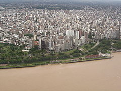
Rosario is the largest city in the central Argentine province of Santa Fe. The city is located 300 km (186 mi) northwest of Buenos Aires, on the west bank of the Paraná River. Rosario is the third-most populous city in the country, and is also the most populous city in Argentina that is not a capital. With a growing and important metropolitan area, Greater Rosario has an estimated population of 1,750,000 as of 2020. One of its main attractions includes the neoclassical, Art Nouveau, and Art Deco architecture that has been retained over the centuries in hundreds of residences, houses and public buildings.

<span class="mw-page-title-main">Santa Fe, Argentina</span> Capital city of Santa Fe Province, Argentina

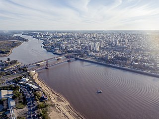
Santa Fe de la Vera Cruz is the capital city of the province of Santa Fe, Argentina. It is situated in north-eastern Argentina, near the junction of the Paraná and Salado rivers. It lies 15 kilometres (9.3 mi) from the Hernandarias Subfluvial Tunnel that connects it to the city of Paraná. The city is also connected by canal with the port of Colastiné on the Paraná River. Santa Fe de la Vera Cruz has about 391,164 inhabitants per the 2010 census [INDEC]. The metropolitan area has a population of 653,073, making it the eighth largest in Argentina. The third largest city in Argentina is Rosario, also located in Santa Fe Province.

<span class="mw-page-title-main">Palermo, Buenos Aires</span> Neighborhood of Buenos Aires in C14, Argentina

Palermo is a barrio or neighborhood of Buenos Aires, Argentina. It is located in the north of the city, near the Rio de la Plata.

<span class="mw-page-title-main">Carlos Thays</span> Argentine architect

Carlos Thays was a French-Argentine landscape architect, and a student of French landscape architect Édouard André.

Departments form the second level of administrative division, and are subdivided in municipalities. They are extended in all of Argentina except for the Province of Buenos Aires and the Autonomous City of Buenos Aires, the national capital, each of which has different administrative arrangements.

<span class="mw-page-title-main">Funes, Santa Fe</span> City in Santa Fe, Argentina

Funes is a small affluent city in the province of Santa Fe, Argentina, located within the metropolitan area of Greater Rosario, about 15 km west from downtown Rosario. It has a population of about 23,500 inhabitants.

<span class="mw-page-title-main">Barrio Lisandro de la Torre</span>

Lisandro de la Torre is a barrio in the north-east of Rosario, Argentina. It carries the name of a renowned local politician, Lisandro de la Torre (1868–1939), but is most commonly referred to as Arroyito.

<span class="mw-page-title-main">Barrio Echesortu</span>

Echesortu is a barrio (neighborhood) in Rosario, Argentina. It is unofficially known by that name even though, from the administrative point of view, its name is Remedios Escalada de San Martín. The neighborhood was formerly a town on its own, named after Ciro Echesortu, the original owner of the land; it was absorbed into the city later.

<span class="mw-page-title-main">Oroño Boulevard</span> Street in Rosario, Argentina

Oroño Boulevard is a street in Rosario, Santa Fe Province, Argentina. It is a two-way boulevard that runs north–south through the center-east of the city, from the coastal avenue by the Paraná River to the southern limit of the urbanized area. Together with the river and with Pellegrini Avenue, it also marks the unofficial limit of the downtown area.

<span class="mw-page-title-main">Pellegrini Avenue (Rosario)</span> Street in Rosario, Argentina

Pellegrini Avenue is a street in Rosario, Santa Fe Province, Argentina. It is a two-way avenue that runs east–west through the center-south of the city, from the coastal avenue by the Paraná River to the western limit of the urbanized area. Together with the river and with Oroño Boulevard, it also marks the unofficial limit of the downtown area.

<span class="mw-page-title-main">Córdoba Street (Rosario)</span> Street in Rosario, Argentina

Córdoba Street is one of the most important streets in Rosario, Santa Fe Province, Argentina. It runs east–west through the center of the city, from the coastal avenue by the Paraná River to the western limit of the urbanized area.

<span class="mw-page-title-main">Parque Urquiza (Rosario)</span>

The Parque Urquiza is a public urban park in Rosario, Argentina. It is located in the southeastern end of the city center, on top of the Paraná River ravines. It is bordered by 3 de Febrero St., the coastal Belgrano Avenue, Chacabuco St. and the beginning of Pellegrini Avenue. Its name is an homage to General Justo José de Urquiza, President of the Argentine Confederation from 1854 to 1860.

<span class="mw-page-title-main">San Martín Street (Rosario)</span> Street in Rosaria, Argentina

San Martín Street is an important street in Rosario, Santa Fe Province, Argentina. It runs north–south through the center of the city, from the coastal avenue by the Paraná River to the southern limit of the urbanized area. It was originally named Calle del Puerto ; the name was changed in 1887 to honour Independence War hero General José de San Martín.

<span class="mw-page-title-main">Plaza 25 de Mayo (Rosario)</span>

Plaza 25 de Mayo is a plaza in Rosario, province of Santa Fe, Argentina. It is Rosario's civic center, and the core of the original settlement. Its name alludes to the date of the May Revolution, which led to the establishment of the first local Argentine government in Buenos Aires. Before 1852, when this name was adopted, it was simply called Plaza Principal.

<span class="mw-page-title-main">Santa Fe Western Railway</span>

The Santa Fe Western Railway was an Argentine railway company which became British-owned in 1900 when it was taken over by the Central Argentine Railway. The company was based in the south of the province of Santa Fe.

There are a number of major football rivalries in Argentina.

<span class="mw-page-title-main">8N</span> 2012 anti-government protest against Cristina Fernández de Kirchner

8N was the name given to a massive anti-Kirchnerism protest in several cities in Argentina, including Buenos Aires, Córdoba, Rosario, Mendoza, Olivos, among many others throughout Greater Buenos Aires and other regions; on 8 November 2012. There were also protests in Argentine embassies and consulates in cities such as New York, Miami, Madrid, Sydney, Bogotá, Santiago de Chile, Naples, Zurich and Barcelona, among others. The protest was considered not only a call to Kirchnerism, but also to the opposition, because they did not have a strong leader.

References

  1. "Estadísticas Climatológicas Normales – período 1981–2010" (in Spanish). Servicio Meteorológico Nacional. Retrieved 21 January 2018.
  2. "Station Rosario" (in French). Météo Climat. Retrieved 11 June 2016.
  3. "Rosario, Santa Fe". Estadísticas meteorológicas decadiales (in Spanish). Oficina de Riesgo Agropecuario. Retrieved 10 June 2015.
  4. "Datos bioclimáticos de 173 localidades argentinas". Atlas Bioclimáticos (in Spanish). Universidad Nacional de La Plata. Retrieved 5 April 2014.
  5. "Rosario AERO Climate Normals 1961–1990". National Oceanic and Atmospheric Administration . Retrieved 29 March 2015.
  6. "Valores Medios de Temperature y Precipitación-Santa Fe: Rosario" (in Spanish). Servicio Meteorológico Nacional. Retrieved 29 March 2015.