Geology of the West Coast Region

Last updated
West Coast Region, New Zealand West Coast inset.png
West Coast Region, New Zealand

The geology of the West Coast of New Zealand's South Island is divided in two by the Alpine Fault, which runs through the Region in a North-East direction. To the West of the fault Paleozoic basement rocks are interluded by plutones and both are unconformably covered in a sedimentary sequence. To the East of the Alpine Fault are the Mesozoic Alpine Schist and Greywacke of the Southern Alps. There are numerous active faults throughout the region. [1]

Contents

Geomorphology and tectonics

Elevation map of the west coast of New Zealand's South Island showing the sharp line formed by the Alpine Fault. North is to the right. Alpine Fault SRTM.jpg
Elevation map of the west coast of New Zealand's South Island showing the sharp line formed by the Alpine Fault. North is to the right.

The West Coast Region extends from the Southern Alps's main divide to the western coast of the South Island. The Southern Alps gets progressively further from the coast, from the south of the Region where the mountains meet the sea, to the north where several other rangers of mountains are between the Southern Alps and the coast. In the central section there is typically a plain between the Alps and the sea which is broken by glacial moraines and isolated hills, made of more resistant granite. [2]

The uplift of the Southern Alps on the Alpine Fault has led to greater precipitation in the West Coast Region. This has increased erosion which has isostatically increased uplift. This uplift is greatest in the centre of the fault where New Zealand's highest mountain, Mt Cook, is found.

The chemical erosion of limestone forms a Karst topography along the coastal part of the northern half of the region.

Basement terranes west of the Alpine Fault

Cartoon cross-section of New Zealand stratigraphy. Cenozoic deformation has been removed for clarity. Cross Section New Zealand geology.jpg
Cartoon cross-section of New Zealand stratigraphy. Cenozoic deformation has been removed for clarity.

Takaka Terrane

The Takaka Terrane contains a vast variety of different sedimentary and igneous rocks and ranges in age from the Cambrian to Devonian. [4] In the West Coast Region it outcrops in the north within the Kahurangi National Park. This terrane contains New Zealand's oldest rocks.

Buller Terrane

The Buller Terrane is composed of Ordovician to Devonian greywacke which has locally been metamorphosed to gneiss.  The terrane is composed of the Golden Bay, Greenland and Reefton groups. The Greenland Group has been metamorphosed to form the Pecksniff Metasedimentary Gneiss. [5] The common name for these is the 'Charleston Gneiss' and it was thought for most of the 20th century that these were the oldest rocks in the country. The Buller Terrane, particularly the Greenland Group is the most common basement unit west of the Alpine Fault on the West Coast.

Median Tectonic Zone

Karamea Suite granite, Cape Foulwind NZL-cape-foulwind-robbe.jpg
Karamea Suite granite, Cape Foulwind

This is series of typically arc related Carboniferous to Early Cretaceous plutones that intrude both the Eastern and Western provinces and are concentrated along the boundary of the two. [6] [7] Along the West Coast the various intrusions include the Karamea Granite and the Rahu, Separation Point and Darran suites. These intrusions have two distinct age ranges, Late Devonian to Carboniferous and Early Cretaceous. [8]

Basement terranes east of the Alpine Fault

Alpine Schist

The Alpine Schist gets progressively higher grade as it approaches the Alpine Fault from the east. Near the Alpine Fault Granite pegmatites and mylonites are present. [9] [10]

Alpine Schist, Fox Glacier, New Zealand Fox Glacier, New Zealand (2).JPG
Alpine Schist, Fox Glacier, New Zealand

Other Eastern Province terranes

In the far South of the West Coast Region, South of Jackson Bay, a number of other basement terranes are present. From West to East these are the Drumduan, Brook Street, Murihiku, Dun Mountain-Maitai, Caples, Aspiring terranes. Near the Alpine Fault these terranes are overprinted by the Alpine Schist.

Cover sequence

East of the Alpine Fault almost all the cover sequence has been eroded due to the high uplift rate. West of the Alpine Fault is a sedimentary sequence representing a marine regression.

Terrestrial breccia and coal measures (Cretaceous to Eocene)

Hawks Crag Breccia, Hawks Crag, Buller River Buller River Hawks Crag 002.JPG
Hawks Crag Breccia, Hawks Crag, Buller River

Unconformably overlying the basement rocks west of the Alpine Fault is a terrestrial sequence that represents Zealandia's progressive movement away from Gondwana. The Hawks Crag Breccia formed from erosion off fault scarps. [11] It is also New Zealand's best source of uranium. [12] These are then overlain by coal measures formed in swamps from the continued extension. These include both the Paparoa and Brunner Coal Measures, which are being extensively mined.

Marine sediments (Oligocene to Miocene)

Inside the Oparara Arch. Karamea Suite granite at the base and a limestone roof. Inside Oparara Arch.jpg
Inside the Oparara Arch. Karamea Suite granite at the base and a limestone roof.

As extension and subsidence continued the West Coast Region was covered with marine sediments in the Oligocene. These included limestone and calcareous mudstones. By the early Miocene the Alpine Fault had become active and a small degree of uplift lead to the formation of some coal measures. [13]

Alluvium (Quaternary)

From the continued uplift of the Southern Alps and it's erosion a thick sequence of alluvium was created forming the plains of the West Coast. These are also associated with a series of glacial sediments. [14]

Economic Geology

The West Coast has both hard rock and alluvial gold. Significant coal deposits are found in the north of region. Jade is found in the central region from the Alpine Schist and in the South of the Region from the Dun Mountain-Maitai Terrane.

Natural Hazards

The Alpine Fault represents the most significant risk on the West Coast and has a 30% chance of generating a magnitude 8 earthquake in the next 50 years. [15] [16]

Tourism

The glaciers that have formed near sea level due to the high precipitation and the Pancake rocks and Oparara Arches are erosional Karst features that have become tourist attractions. [17]

See also

Related Research Articles

<span class="mw-page-title-main">Kaikōura Peninsula</span>

The Kaikōura Peninsula is located in the northeast of New Zealand's South Island. It protrudes 5 kilometres (3.1 mi) into the Pacific Ocean. The town of Kaikōura is located on the north shore of the peninsula. The peninsula has been settled by Maori for approximately 1000 years, and by Europeans since the 1800s, when whaling operations began off the Kaikōura Coast. Since the end of whaling in 1922 whales have been allowed to thrive and the region is now a popular whale watching destination.

In geology, a terrane is a crust fragment formed on a tectonic plate and accreted or "sutured" to crust lying on another plate. The crustal block or fragment preserves its distinctive geologic history, which is different from the surrounding areas—hence the term "exotic" terrane. The suture zone between a terrane and the crust it attaches to is usually identifiable as a fault. A sedimentary deposit that buries the contact of the terrane with adjacent rock is called an overlap formation. An igneous intrusion that has intruded and obscured the contact of a terrane with adjacent rock is called a stitching pluton.

<span class="mw-page-title-main">Alpine Fault</span> Right-lateral strike-slip fault, that runs almost the entire length of New Zealands South Island.

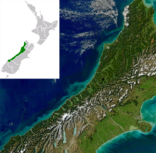
The Alpine Fault is a geological fault that runs almost the entire length of New Zealand's South Island, being about 600 km (370 mi). long, and forms the boundary between the Pacific Plate and the Australian Plate. The Southern Alps have been uplifted on the fault over the last 12 million years in a series of earthquakes. However, most of the motion on the fault is strike-slip, with the Tasman district and West Coast moving north and Canterbury and Otago moving south. The average slip rates in the fault's central region are about 38 mm (1.5 in) a year, very fast by global standards. The last major earthquake on the Alpine Fault was in about 1717 AD with a great earthquake magnitude of Mw8.1. The probability of another one occurring within the next 50 years is estimated at 75 percent.

<span class="mw-page-title-main">Torlesse Composite Terrane</span> Terrane found in New Zealand

The Torlesse Composite Terrane is a plate tectonic terrane forming part of the South Island of New Zealand. It contains the Rakaia, Aspiring and Pahau Terranes and the Esk Head Belt. Greywacke is the dominant rock type of the composite terrane; argillite is less common and there are minor basalt occurrences. The Torlesse Composite Terrane is found east of the Alpine Fault in the Southern Alps of New Zealand. Its southern extent is a cryptic boundary with the Caples Terrane within the Haast Schists in Central Otago. It is named for the Torlesse Range in Canterbury.

<span class="mw-page-title-main">Haast Schist</span> Metamorphic unit in New Zealand

The Haast Schist, which contains both the Alpine and Otago Schist, is a metamorphic unit in the South Island of New Zealand. It extends from Central Otago, along the eastern side of the Alpine Fault to Cook Strait. There are also isolated outcrops of the Haast Schist within the central North Island. The schists were named after Haast Pass on the West Coast. The Haast Schist can be divided geographically from north to south into the Kaimanawa, Terawhiti, Marlborough, Alpine, Otago and Chatham schist.

<span class="mw-page-title-main">Geology of New Zealand</span> Overview of the geology of New Zealand

The geology of New Zealand is noted for its volcanic activity, earthquakes and geothermal areas because of its position on the boundary of the Australian Plate and Pacific Plates. New Zealand is part of Zealandia, a microcontinent nearly half the size of Australia that broke away from the Gondwanan supercontinent about 83 million years ago. New Zealand's early separation from other landmasses and subsequent evolution have created a unique fossil record and modern ecology.

<span class="mw-page-title-main">Geology of the Canterbury Region</span> Overview of the geology of Canterbury, New Zealand

Canterbury in New Zealand is the portion of the South Island to the east of the Southern Alps / Kā Tiritiri o te Moana, from the Waiau Uwha River in the north, to the Waitaki River in the south.

<span class="mw-page-title-main">Geology of the Tasman District</span>

The Tasman Region, and the small adjoining Nelson Region, form one of the more geologically interesting regions of New Zealand. It contains the oldest rocks of anywhere on New Zealand's main islands. It contains all the main terranes that make up New Zealand's basement. These basement rocks include Ultramafic rocks, such as Serpentine and Dunite, and valuable minerals, such as Gold. The Nelson Region is bordered to the south by the Alpine Fault, the main fault forming the boundary between the Pacific Plate and the Indo-Australian Plate, that generated the Southern Alps.

<span class="mw-page-title-main">Clarence Fault</span> Active fault in New Zealand

The Clarence Fault is an active dextral strike-slip fault in the northeastern part of South Island, New Zealand. It forms part of the Marlborough Fault System, which accommodates the transfer of displacement along the oblique convergent boundary between the Indo-Australian Plate and Pacific Plate, from the transform Alpine Fault to the Hikurangi Trench subduction zone.

<span class="mw-page-title-main">Dun Mountain-Maitai Terrane</span> Geological feature in New Zealand

The Dun Mountain-Maitai Terrane comprises the Dun Mountain Ophiolite Belt, Maitai Group and Patuki Mélange. The Dun Mountain Ophiolite is an ophiolite of Permian age located in New Zealand's South Island. Prehistorically this ophiolite was quarried by Māori for both metasomatized argillite and pounamu (jade) which was used in the production of tools and jewellery.

<span class="mw-page-title-main">Takaka Terrane</span> Terrane in Tasman, New Zealand

The Takaka Terrane is a Paleozoic terrane that outcrops in the South Island of New Zealand. It is most extensively exposed within the Kahurangi National Park in the Tasman District. The terrane is mostly made up of marble and volcanic rocks but is highly variable in composition. It ranges in age from mid-Cambrian to Devonian time, including New Zealand's oldest rocks, which are found in the Cobb Valley in north-west Nelson. The Cobb Valley is also the location of "Trilobite Rock" a glacial dropstone made from the moulted exoskeletons of trilobites. Asbestos was mined in the Cobb Valley from the Takaka Terrene between the late 1880s and 1917. The Takaka Terrane is highly deformed and has been intruded by many batholiths.

Kapuni is an onshore natural gas-condensate field located in the Taranaki Basin, a ~100,000 km2 partially-inverted rift basin on the Taranaki Peninsula in the North Island, New Zealand. Discovered in 1959 and brought into production in 1970, Kapuni remained New Zealand's only producing gas-condensate field until the offshore Maui gas field began production in 1979.

<span class="mw-page-title-main">Stratigraphy of New Zealand</span>

This is a list of the units into which the rock succession of New Zealand is formally divided. As new geological relationships have been discovered new names have been proposed and others are made obsolete. Not all these changes have been universally adopted. This table is based on the 2014 New Zealand Stratigraphic Lexicon (Litho2014). However, obsolete names that are still in use and names postdating the lexicon are included if it aids in understanding.

<span class="mw-page-title-main">Banks Peninsula Volcano</span> An extinct volcano in New Zealand

The Banks Peninsula Volcano is an extinct volcanic complex to the east of Christchurch on New Zealand's South Island. While the volcano is highly eroded it still forms the majority of Banks Peninsula with a highest point of 919 m (3,015 ft). It is a composite of two main eruptive centres one originating at Lyttelton Harbour, the other at Akaroa Harbour. The eruptions were predominantly basaltic, with associated andesite and trachytes, with minor rhyolite. The volcanic activity occurred in the Late Miocene and possibly extended into the Early Pliocene. There are four volcanic groups, all of which are within the Māui Supergroup. The Christchurch earthquakes led to rumors of a possible eruption, however, there is no known magma chamber beneath the volcano and there has not been any sign of volcanic activity in the last 5 million years.

<span class="mw-page-title-main">Southland Syncline</span>

The Southland Syncline is a major geological structure located in the Southland Region of New Zealand's South Island. The syncline folds the Mesozoic greywackes of the Murihiku Terrane. The northern limb of the fold is steep to overturned, while the southern limb dips shallowly to the northeast. The axial plan dips to the northeast and the axis plunges to the southeast.

<span class="mw-page-title-main">Waitemata Group</span>

The Waitemata Group is an Early Miocene geologic group that is exposed in and around the Auckland Region of New Zealand, between the Whangarei Harbour in the North and the Raglan Harbour in the South. The Group is predominantly composed of deep water sandstone and mudstone (flysch). The sandstone dominated units form the cliffs around the Waitemata Harbour and rare more resistant conglomerates underlie some of Auckland's prominent ridges.

<span class="mw-page-title-main">Geology of New Caledonia</span>

The geology of New Caledonia includes all major rock types, which here range in age from ~290 million years old (Ma) to recent. Their formation is driven by alternate plate collisions and rifting. The mantle-derived Eocene Peridotite Nappe is the most significant and widespread unit. The igneous unit consists of ore-rich ultramafic rocks thrust onto the main island. Mining of valuable metals from this unit has been an economical pillar of New Caledonia for more than a century.

The Waitākere volcano, also known as the Manukau volcano, was a Miocene era volcano that formed off the west coast of the modern Auckland Region of New Zealand's North Island. Erupting intermittently between 23 million and 15 million years ago, the volcano was at one point one of the tallest mountains in New Zealand. The volcano alternated between periods as a seamount and as a volcanic island, before tectonic forces raised the volcano up from the seafloor 17 million years ago. Volcanism at the site ceased 15 million years ago and the cone has mostly eroded, however the modern Waitākere Ranges are formed from the remnants of the volcano's eastern slopes. A number of visible volcanic sites associated with the Waitākere volcano remain around Auckland, including Pukematekeo, Karekare and Lion Rock.

The volcanic activity in the South Island of New Zealand terminated 5 million years ago as the more northern parts of the North Island became extremely volcanically active. The South Islands surface geology reflects the uplift of the Pacific Plate as it collides with the Indo-Australian Plate along the Alpine Fault over the last 12 million years and the termination of subduction, about 100 to 105 million years ago. There is a very small chance of reactivation of volcanism in the Dunedin Volcano. This chance is made slightly higher by the observation that Southland's Solander Islands / Hautere just off the coast of the South Island were active as recently as 50,000 years old, and on a larger scale 150,000 years old.

References

  1. Nathan et al., 2002, p.V
  2. Nathan et al., 2002, p. 3–9
  3. Mortimer, N; Rattenbury, MS; King, PR; Bland, KJ; Barrell, DJA; Bache, F; Begg, JG; Campbell, HJ; Cox, SC; Crampton, JS; Edbrooke, SW; Forsyth, PJ; Johnston, MR; Jongens, R; Lee, JM; Leonard, GS; Raine, JI; Skinner, DNB; Timm, C; Townsend, DB; Tulloch, AJ; Turnbull, IM; Turnbull, RE (2014). "High-level stratigraphic scheme for New Zealand rocks". New Zealand Journal of Geology and Geophysics. 57 (4): 402–419. doi: 10.1080/00288306.2014.946062 . ISSN   0028-8306.
  4. Münker, Carsten; Cooper, Roger (1999-09-01). "The Cambrian arc complex of the Takaka Terrane, New Zealand: An integrated stratigraphical, paleontological and geochemical approach". New Zealand Journal of Geology and Geophysics. 42 (3): 415–445. doi: 10.1080/00288306.1999.9514854 . ISSN   0028-8306.
  5. Palmer, M. C.; Scott, J. M.; Muhling, J. R.; Kennedy, A. K. (2015-01-02). "Carboniferous metamorphism and partial melting of the Greenland Group in the Jackson River valley, south Westland". New Zealand Journal of Geology and Geophysics. 58 (1): 22–32. doi: 10.1080/00288306.2014.982661 . ISSN   0028-8306.
  6. Bradshaw, J. D. (1993-03-01). "A review of the Median Tectonic Zone: Terrane boundaries and terrane amalgamation near the Median Tectonic Line". New Zealand Journal of Geology and Geophysics. 36 (1): 117–125. doi: 10.1080/00288306.1993.9514559 . ISSN   0028-8306.
  7. Mortimer, N.; Tulloch, A.J.; Spark, R.N.; Walker, N.W.; Ladley, E.; Allibone, A.; Kimbrough, D.L. (1999). "Overview of the Median Batholith, New Zealand: a new interpretation of the geology of the Median Tectonic Zone and adjacent rocks". Journal of African Earth Sciences. 29 (1): 257–268. doi:10.1016/S0899-5362(99)00095-0. ISSN   1464-343X.
  8. Nathan et al., 2002, p.11
  9. Grapes, R.; Watanabe, T. (1992). "Metamorphism and uplift of Alpine schist in the Franz Josef–Fox Glacier area of the Southern Alps, New Zealand". Journal of Metamorphic Geology. 10 (2): 171–180. doi:10.1111/j.1525-1314.1992.tb00077.x. ISSN   1525-1314.
  10. Cooper, Alan F.; Ireland, Trevor R. (2015). "The Pounamu terrane, a new Cretaceous exotic terrane within the Alpine Schist, New Zealand; tectonically emplaced, deformed and metamorphosed during collision of the LIP Hikurangi Plateau with Zealandia". Gondwana Research. 27 (3): 1255–1269. doi:10.1016/j.gr.2013.11.011. ISSN   1342-937X.
  11. Nathan, Simon; Taonga, New Zealand Ministry for Culture and Heritage Te Manatu. "Hawks Crag Breccia". teara.govt.nz. Retrieved 2019-03-03.
  12. Wodzicki, A. (1959-05-01). "Radioactive boulders in Hawks Crag Breccia". New Zealand Journal of Geology and Geophysics. 2 (2): 385–393. doi: 10.1080/00288306.1959.10417657 . ISSN   0028-8306.
  13. Nathan et al., 2002, p.29
  14. Nathan et al., 2002, p.31
  15. Nathan et al., 2002, p.46-47
  16. "New study says Alpine Fault quake interval shorter than thought: GNS Science". stuff www.stuff.co.nz. 6 March 2017. Retrieved 17 September 2018.
  17. "Official Site | West Coast, New Zealand". www.westcoast.co.nz. Retrieved 2019-03-03.

Bibliography