
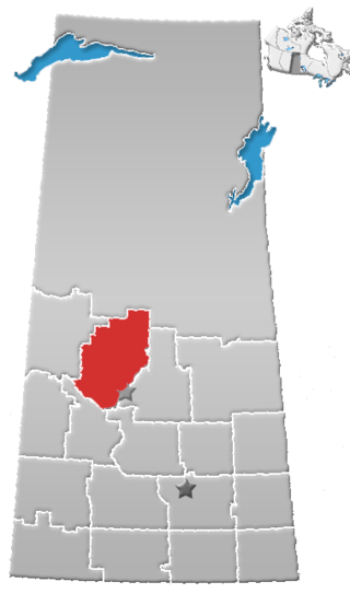
Gordon 86 is a Cree Indian reserve in Saskatchewan, Canada located about 61 kilometres (38 mi) north-west of Fort Qu'Appelle. Also known as the George Gordon Reserve, it is one of three territories of the George Gordon First Nation, as arranged by the signing of Treaty 4. The reserve has an area of 14,438.3 hectares. In the 2016 Canadian Census, it recorded a population of 837 living in 218 of its 238 total private dwellings. In the same year, its Community Well-Being index was calculated at 52 of 100, compared to 58.4 for the average First Nations community and 77.5 for the average non-Indigenous community. It is almost completely surrounded by the rural municipality of Touchwood No. 248.
The George Gordon First Nation is a First Nations band government located near the village of Punnichy, Saskatchewan, in Canada. The nation has an enrolled population of 3,752 people, 1,191 of whom live on the band's reserves. Chief Byron Bitternose leads the First Nation. Their territory is located on the Gordon 86 reserve, as arranged by Treaty 4.
Division No. 16 is one of eighteen census divisions in the province of Saskatchewan, Canada, as defined by Statistics Canada. It is located in the north-central part of the province. The most populous community in this division is North Battleford.

The Treaty Four Reserve Grounds 77 are an Indian reserve in Saskatchewan, Canada, shared by 33 band governments from Saskatchewan and Manitoba. The Reserve Grounds are located adjacent to and west of Fort Qu'Appelle. In the 2016 Canadian Census, they recorded a population of 15 living in 6 of their 8 total private dwellings.

Amisk Lake 184 is an Indian reserve of the Peter Ballantyne Cree Nation in Saskatchewan.

Amiskosakahikan 210 is an Indian reserve of the Peter Ballantyne Cree Nation in Saskatchewan. It is 11 kilometres southwest of Creighton.

Birch Portage 184A is an Indian reserve of the Peter Ballantyne Cree Nation in Saskatchewan. It is about 30 miles northwest of Flin Flon.

Budd's Point 20D is an Indian reserve of the Cumberland House Cree Nation in Saskatchewan. It is 85 kilometres south of Flin Flon.
Carrot River 29A is an Indian reserve of the Red Earth Cree Nation in Saskatchewan. It is 48 miles east of Nipawin. In the 2016 Canadian Census, it recorded a population of 829 living in 127 of its 127 total private dwellings. In the same year, its Community Well-Being index was calculated at 40 of 100, compared to 58.4 for the average First Nations community and 77.5 for the average non-Indigenous community.
Cowessess 73 is an Indian reserve of the Cowessess First Nation in Saskatchewan. It is 13 kilometres (8.1 mi) north-west of Broadview. In the 2016 Canadian Census, it recorded a population of 540 living in 190 of its 214 total private dwellings. In the same year, its Community Well-Being index was calculated at 63 of 100, compared to 58.4 for the average First Nations community and 77.5 for the average non-Indigenous community.

Cowessess 73A is an Indian reserve of the Cowessess First Nation in Saskatchewan. It is 31 kilometres west of Esterhazy.

Cumberland House Cree Nation 20 is an Indian reserve of the Cumberland House Cree Nation in Saskatchewan. The reserve is on Cumberland Island in the Saskatchewan River Delta, about 96 kilometres (60 mi) south-west of Flin Flon.

The Gold Eagle Reserve is an Indian reserve of the Mosquito, Grizzly Bear's Head, Lean Man First Nations in Saskatchewan. It is an urban reserve in the city of North Battleford.

Kahkewistahaw 72 is an Indian reserve of the Kahkewistahaw First Nation in Saskatchewan. It is about 13 kilometres (8.1 mi) north of Broadview. In the 2016 Canadian Census, it recorded a population of 502 living in 146 of its 184 total private dwellings. In the same year, its Community Well-Being index was calculated at 58 of 100, compared to 58.4 for the average First Nations community and 77.5 for the average non-Indigenous community.

Keeseekoose 66-KE-04 is an Indian reserve of the Keeseekoose First Nation in Saskatchewan. It is about 15 kilometres (9.3 mi) east of Canora. In the 2016 Canadian Census, it was recorded as uninhabited.

Keeseekoose 66-KE-05 is an Indian reserve of the Keeseekoose First Nation in Saskatchewan. It is about 19 kilometres (12 mi) north-east of Canora. In the 2016 Canadian Census, it recorded a population of 5 living in 1 of its 2 total private dwellings.

Muskeg Lake 102 is an Indian reserve of the Muskeg Lake Cree Nation in Saskatchewan. It is 93 kilometres north of Saskatoon. In the 2016 Canadian Census, it recorded a population of 274 living in 104 of its 112 total private dwellings. In the same year, its Community Well-Being index was calculated at 57 of 100, compared to 58.4 for the average First Nations community and 77.5 for the average non-Indigenous community.

Sakimay 74 is an Indian reserve of the Zagime Anishinabek in Saskatchewan. It is 16 kilometres northwest of Broadview. In the 2016 Canadian Census, it recorded a population of 147 living in 46 of its 170 total private dwellings. In the same year, its Community Well-Being index was calculated at 52 of 100, compared to 58.4 for the average First Nations community and 77.5 for the average non-Indigenous community.
White Bear 70 is an Indian reserve of the White Bear First Nations in Saskatchewan. It is 13 kilometres north of Carlyle and encompasses a total of 12,038.4 hectares. In the 2016 Canadian Census, it recorded a population of 691 living in 237 of its 972 total private dwellings. In the same year, its Community Well-Being index was calculated at 60 of 100, compared to 58.4 for the average First Nations community and 77.5 for the average non-Indigenous community.
