
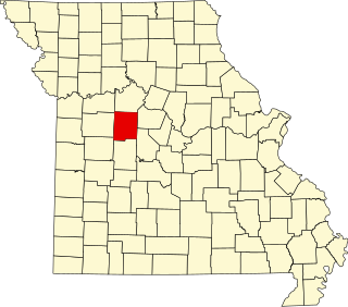
Pettis County is a county located in west central U.S. state of Missouri. As of the 2010 census, the population was 42,201. Its county seat is Sedalia. The county was organized January 24, 1833, and named after former U.S. Representative Spencer Darwin Pettis.
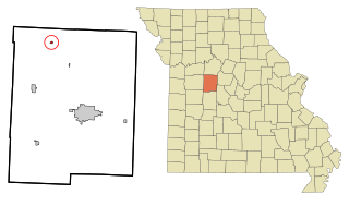
Houstonia is a city in northwest Pettis County, Missouri, United States. The population was 220 at the 2010 census.

Ionia is a village in northern Benton and southern Pettis counties in the U.S. state of Missouri. The population was 88 at the 2010 census.
Clifton City is an unincorporated community in southwestern Cooper County, Missouri, United States. The community is located on Missouri Route 135 and Missouri Route BB. The nearest town is Otterville approximately five miles to the south. It is also 10 miles northeast of Sedalia. The Lamine River flows past one half mile east of the town. The Cooper - Pettis county boundary lies three-quarters of a mile west of the location. The Katy Trail State Park passes the south edge of the community.
Thornfield is an unincorporated community in Ozark County, Missouri, United States. It is located 15 miles (24 km) northwest of Gainesville, on Route 95 at the Little North Fork of the White River on the edge of the Mark Twain National Forest between Wasola to the northeast and Longrun to the southwest. Hammond, the site of the historic Hammond Mill, lies on the Little North Fork 2.5 miles (4.0 km) southeast of Thornfield. Thornfield has a post office with ZIP code 65762.
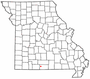
Elijah is an unincorporated community in eastern Ozark County, Missouri, United States. It is located approximately twenty-two miles west of West Plains on Missouri Supplemental Route V, one mile south of U.S. Route 160. The community is located on North Bridges Creek, with Spoon Spring within the village.
Newland is an unincorporated community in northeast Pettis County, in the U.S. state of Missouri. The community is on Missouri Route EE approximately eight miles northeast of Sedalia.
Spring Fork is an unincorporated community in Pettis County, Missouri, United States.
Tedieville was an unincorporated community in northern Pettis County, Missouri, United States.
Longwood is an unincorporated community in northeast Pettis County, Missouri, United States. It is located on Missouri Route BB approximately two miles east of US Route 65 and thirteen miles north of Sedalia.
Postal is an unincorporated community in Pettis County, Missouri, United States.
Cookville is an extinct town in southwestern Pulaski County, in the U.S. state of Missouri. The GNIS classifies it as a populated place. The town site is along Roubidoux Creek within the southern part of Fort Leonard Wood. The community of Greenview is located two miles to the west on Missouri Route 17 along the western boundary of the military reservation and adjacent to the Pulaski-Laclede county line.
Althea is an extinct town in eastern Ozark County, in the Ozarks of southern Missouri, United States. The GNIS classifies it as a populated place. The location is on the North Fork River at the crossing of Missouri Route H, at an elevation of 623 feet. It is approximately five miles northeast of Tecumseh.
Luna is an extinct town in Ozark County, in the U.S. state of Missouri. The GNIS classifies it as a populated place. The community is on a ridge between Bryant Creek to the east and Pine Creek to the west and is located on Missouri Route FF. Zanoni, on Missouri Route 181, lies approximately two miles to the northwest. The community church is one and one-half miles west on Caney Creek and Missouri Route AA. The Pine Creek confluence with Bryant Creek is one and one-quarter miles to the south, at the north end of Norfork Lake.
Manila is an unincorporated community in southern Pettis County, in the U.S. state of Missouri.
Muddy Creek is a stream in Johnson and Pettis Counties in the U.S. state of Missouri. It is a tributary of Lamine River.
Stokley is an unincorporated community in northwest Pettis County, in the U.S. state of Missouri.
Iuka Springs is an extinct town in St. Clair County, in the U.S. state of Missouri. The GNIS classifies it as a populated place.
Rector is an extinct town in northwest Shannon County, in the U.S. state of Missouri. The GNIS classifies it as a populated place. The community is located in Rector Hollow, which is a tributary to Gladden Creek approximately one mile to the west. It is on Missouri Route J two miles west of Missouri Route 19.
Mingsville is an extinct town in northeastern Wright County, in the U.S. state of Missouri. The GNIS classifies it as a populated place.

