Germanic Trias

Last updated
System Series Stage Age (Ma)European lithostratigraphy
Jurassic Lower Hettangian younger Lias
Triassic Upper Rhaetian 199.6–203.6
Keuper
Norian 203.6–216.5
Carnian 216.5–228.7
Middle Ladinian 228.7–237.0
Muschelkalk
Anisian 237.0–245.9
Bunter or Buntsandstein
Lower Olenekian 245.9–249.5
Induan 249.5–251.0
Permian Lopingian Changhsingian older
Zechstein
Major lithostratigraphic units of northwest Europe with the ICS's geologic timescale of the Triassic. [1]

The Germanic Trias Supergroup (German : Germanische Trias-Supergruppe) is a lithostratigraphic unit (a sequence of rock strata) in the subsurface of large parts of western and central Europe (north of the Alps) and the North Sea. Almost all of the Germanic Trias was deposited during the Triassic period and consists of three clearly different units: Buntsandstein, Muschelkalk and Keuper, that gave the period its name (Triassic means "threefold"). In the past the names of these three units were also used as units in the geologic timescale, but in modern literature they only have a lithostratigraphic meaning.

German language West Germanic language

German is a West Germanic language that is mainly spoken in Central Europe. It is the most widely spoken and official or co-official language in Germany, Austria, Switzerland, South Tyrol (Italy), the German-speaking Community of Belgium, and Liechtenstein. It is also one of the three official languages of Luxembourg and a co-official language in the Opole Voivodeship in Poland. The languages which are most similar to German are the other members of the West Germanic language branch: Afrikaans, Dutch, English, the Frisian languages, Low German/Low Saxon, Luxembourgish, and Yiddish. There are also strong similarities in vocabulary with Danish, Norwegian and Swedish, although those belong to the North Germanic group. German is the second most widely spoken Germanic language, after English.

Lithostratigraphy

Lithostratigraphy is a sub-discipline of stratigraphy, the geological science associated with the study of strata or rock layers. Major focuses include geochronology, comparative geology, and petrology. In general a stratum will be primarily igneous or sedimentary relating to how the rock was formed.

Europe Continent in the Northern Hemisphere and mostly in the Eastern Hemisphere

Europe is a continent located entirely in the Northern Hemisphere and mostly in the Eastern Hemisphere. It is bordered by the Arctic Ocean to the north, the Atlantic Ocean to the west and the Mediterranean Sea to the south. It comprises the westernmost part of Eurasia.

Contents

Origin

The Germanic Trias formed in the large Germanic Basin, a basin that covered much of midwestern Europe (including the south of the North Sea and Baltic Sea) during the Triassic. The Muschelkalk has a predominantly marine facies whereas the Buntsandstein and Keuper are mostly continental.

The Germanic Basin is a large region of sedimentation in Western and Central Europe that, during the Permian and Triassic periods, extended from England in the west to the eastern border of Poland in the east.

Baltic Sea A sea in Northern Europe bounded by the Scandinavian Peninsula, the mainland of Europe, and the Danish islands

The Baltic Sea is a marginal sea of the Atlantic Ocean, enclosed by Denmark, Estonia, Finland, Latvia, Lithuania, Sweden, northeast Germany, Poland, Russia and the North and Central European Plain.

Continent Very large landmass identified by convention

A continent is one of several very large landmasses of the world. Generally identified by convention rather than any strict criteria, up to seven regions are commonly regarded as continents. Ordered from largest in area to smallest, they are: Asia, Africa, North America, South America, Antarctica, Europe, and Australia.

Stratigraphy

In the central parts of the Germanic Basin, the Germanic Trias has an average thickness of 800 meters, but regional differences are considerable. In the north of Germany the thickness of the Buntsandstein alone can exceed 1400 meters. The Germanic Trias lies on top of the Permian Zechstein Group and below Lower Jurassic units, such as the Lias Group or Altena Group.

The Permian is a geologic period and system which spans 47 million years from the end of the Carboniferous Period 298.9 million years ago (Mya), to the beginning of the Triassic period 251.902 Mya. It is the last period of the Paleozoic era; the following Triassic period belongs to the Mesozoic era. The concept of the Permian was introduced in 1841 by geologist Sir Roderick Murchison, who named it after the city of Perm.

The Lias Group or Lias is a lithostratigraphic unit found in a large area of western Europe, including the British Isles, the North Sea, the Low Countries and the north of Germany. It consists of marine limestones, shales, marls and clays.

The base is not defined in the same way everywhere. In northern Germany the base is formed by the Calvörde Beds, in the Spessart and Odenwald by the base of the Heigenbrücken-Sandstone. Radiometric dating has shown the age of the Germanic Trias is not totally corresponding with the Triassic period. The base of the Buntsandstein was formed during the Changhsingian, the uppermost stage of the Permian, about 252  million years ago. The top of the Keuper is Rhaetian in age and at about 200.5  million years ago at least a few million years older than the Triassic-Jurassic boundary. Usually there is a stratigraphic hiatus between the base of the Lias and top of the Germanic Trias.

Spessart low mountain range in Germany

Spessart is a Mittelgebirge, a range of low wooded mountains, in the States of Bavaria and Hesse in Germany. It is bordered by the Vogelsberg, Rhön and Odenwald. The highest elevation is the Geiersberg at 586 metres NN.

Odenwald low mountain range in Hesse, Bavaria and Baden-Württemberg in Germany

The Odenwald  is a low mountain range in the German states of Hesse, Bavaria and Baden-Württemberg.

Radiometric dating, radioactive dating or radioisotope dating is a technique used to date materials such as rocks or carbon, in which trace radioactive impurities were selectively incorporated when they were formed. The method compares the abundance of a naturally occurring radioactive isotope within the material to the abundance of its decay products, which form at a known constant rate of decay. The use of radiometric dating was first published in 1907 by Bertram Boltwood and is now the principal source of information about the absolute age of rocks and other geological features, including the age of fossilized life forms or the age of the Earth itself, and can also be used to date a wide range of natural and man-made materials.

In German lithostratigraphy, Buntsandstein, Muschelkalk and Keuper are seen as groups. Dutch lithostratigraphy divides the Germanic Trias along other boundaries in a Lower Germanic Trias Group and an Upper Germanic Trias Group. The Dutch Keuper and Muschelkalk have the status of formations while the Dutch Buntsandstein is subdivided in a number of formations. The Bunter of British stratigraphy is similar in age, lithology and facies to the Buntsandstein.

A group in stratigraphy is a lithostratigraphic unit, a part of the geologic record or rock column that consists of defined rock strata. Groups are generally divided into individual formations. Groups may sometimes be divided into "subgroups" and are themselves sometimes grouped into "supergroups".

Netherlands Constituent country of the Kingdom of the Netherlands in Europe

The Netherlands is a country located mainly in Northwestern Europe. The European portion of the Netherlands consists of twelve separate provinces that border Germany to the east, Belgium to the south, and the North Sea to the northwest, with maritime borders in the North Sea with Belgium, Germany and the United Kingdom. Together with three island territories in the Caribbean Sea—Bonaire, Sint Eustatius and Saba— it forms a constituent country of the Kingdom of the Netherlands. The official language is Dutch, but a secondary official language in the province of Friesland is West Frisian.

Bunter Pebble Beds are sandstone deposits containing rounded pebbles. They can be found in Warwickshire, Cheshire, Staffordshire, Nottinghamshire, Yorkshire, Devon and Dorset in England. They are thought to be alluvial deposits and, judging from the rounding of the mainly quartzite pebbles, to have resulted from prolonged transportation in a large and turbulent river, resulting in powerful abrasion. The deposits in the English Midlands are thought to have been transported in this way northwards from Brittany, France. This supposed river has been called the "Budleighensis", after the Devon village of Budleigh Salterton, a site where such deposits were discovered. The depositions took place in the lower Triassic period. Some newer conglomerates, e.g. near Ryton in Warwickshire, are thought to have arisen during the Ice Age by reworking and southward transportation of older deposits by ice flows.

See also

Related Research Articles

The Triassic is a geologic period and system which spans 50.6 million years from the end of the Permian Period 251.9 million years ago (Mya), to the beginning of the Jurassic Period 201.3 Mya. The Triassic is the first and shortest period of the Mesozoic Era. Both the start and end of the period are marked by major extinction events.

Early Jurassic

The Early Jurassic epoch is the earliest of three epochs of the Jurassic period. The Early Jurassic starts immediately after the Triassic-Jurassic extinction event, 201.3 Ma, and ends at the start of the Middle Jurassic 174.1 Ma.

The Muschelkalk is a sequence of sedimentary rock strata in the geology of central and western Europe. It has a Middle Triassic age and forms the middle part of the tripartite Germanic Trias, that give the Triassic its name, lying above the older Buntsandstein and below the younger Keuper. The Muschelkalk consists of a sequence of limestone and dolostone beds.

Early Triassic first of three epochs of the Triassic period of the geologic timescale

The Early Triassic is the first of three epochs of the Triassic Period of the geologic timescale. It spans the time between 251.902 Ma and 247.2 Ma. Rocks from this epoch are collectively known as the Lower Triassic, which is a unit in chronostratigraphy. The Early Triassic is the oldest epoch of the Mesozoic Era and is divided into the Induan and Olenekian ages.

The Keuper is a lithostratigraphic unit in the subsurface of large parts of west and central Europe. The Keuper consists of dolostone, shales or claystones and evaporites that were deposited during the Middle and Late Triassic epochs. The Keuper lies on top of the Muschelkalk and under the predominantly Lower Jurassic Lias or other Early Jurassic strata.

Geology of Alderley Edge mountain in United Kingdom

Alderley Edge in Cheshire is one of the classic locations for the study of Triassic sandstones in the United Kingdom]. Numerous scientists from the early 19th century up to the present day have studied the area and it is a popular field site for universities around the UK.

The Rotliegend, Rotliegend Group or Rotliegendes is a lithostratigraphic unit of latest Carboniferous to Guadalupian age that is found in the subsurface of large areas in western and central Europe. The Rotliegend mainly consists of sandstone layers. It is usually covered by the Zechstein and lies on top of regionally different formations of late Carboniferous age.

The Buntsandstein or Bunter sandstone is a lithostratigraphic and allostratigraphic unit in the subsurface of large parts of west and central Europe. The Buntsandstein predominantly consists of sandstone layers of the Lower Triassic series and is one of three characteristic Triassic units, together with the Muschelkalk and Keuper that form the Germanic Trias Supergroup.

The Upper Keuper or Rhätsandstein (Rhätsandstein) is a lithostratigraphic subgroup of the Keuper in the Germanic Trias. It currently has only one formation, the Exter Formation. The lithostratigraphic unit is underlain by the Middle Keuper subgroup and overlain, in the North German Basin, by the Lias and, in the South German Basin by the Black Jurassic.

Geology of the Pyrenees

The Pyrenees are a 430-kilometre-long, roughly east–west striking, intracontinental mountain chain that divide France, Spain, and Andorra. The belt has an extended, polycyclic geological evolution dating back to the Precambrian. The chain's present configuration is due to the collision between the microcontinent Iberia and the southwestern promontory of the European Plate. The two continents were approaching each other since the onset of the Upper Cretaceous (Albian/Cenomanian) about 100 million years ago and were consequently colliding during the Paleogene (Eocene/Oligocene) 55 to 25 million years ago. After its uplift, the chain experienced intense erosion and isostatic readjustments. A cross-section through the chain shows an asymmetric flower-like structure with steeper dips on the French side. The Pyrenees are not solely the result of compressional forces, but also show an important sinistral shearing.

Erfurt Formation formation

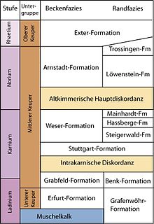
The Erfurt Formation, also known as the Lower Keuper, is a stratigraphic formation of the Keuper group and the Germanic Trias supergroup. It was deposited during the Ladinian stage of the Triassic period. It lies above the Upper Muschelkalk and below the Middle Keuper.

North German basin A passive-active rift basin in central and west Europe

The North German Basin is a passive-active rift basin located in central and west Europe, lying within the southeastern most portions of the North Sea and the southwestern Baltic Sea and across terrestrial portions of northern Germany, Netherlands, and Poland. The North German Basin is a sub-basin of the Southern Permian Basin, that accounts for a composite of intra-continental basins composed of Permian to Cenozoic sediments, which have accumulated to thicknesses around 10–12 kilometres (6–7.5 mi). The complex evolution of the basin takes place from the Permian to the Cenozoic, and is largely influenced by multiple stages of rifting, subsidence, and salt tectonic events. The North German Basin also accounts for a significant amount of Western Europe's natural gas resources, including one of the worlds largest natural gas reservoir, the Groningen gas field.

Black Jurassic

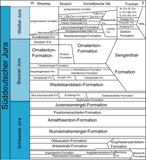
The Black Jurassic or Black Jura in earth history refers to the lowest of the three lithostratigraphic units of the South German Jurassic, the latter being understood not as a geographical, but a geological term in the sense of a lithostratigraphic super group. Formerly and even occasionally today in the popular scientific literature, this term is equated to the chronostratigraphic series of the Lower Jurassic. This is however not quite correct, because the Black Jura does not exactly coincide with the chronostratigraphic boundaries of the Lower Jurassic. In addition, the term lias, which was formerly frequently used as a synonym, should no longer be used in connexion with the South German Jurassic. Instead, the term lias, or North German Lias, should be reserved for the roughly equivalent lithostratigraphic unit in the North German Jurassic. The deposition of the Black Jurassic took place about 199 to 175 million years ago. The Black Jurassic follows the lithostratigraphic unit of the Keuper and is superimposed on the lithostratigraphic group of the Brown Jurassic.

Geology of Germany

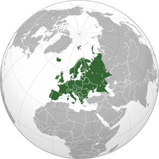
The geology of Germany is heavily influenced by several phases of orogeny in the Paleozoic and the Cenozoic, by sedimentation in shelf seas and epicontinental seas and on plains in the Permian and Mesozoic as well as by the Quaternary glaciations.

The Worcester Basin or Worcester Graben is a sedimentary basin in central England, filled with mainly Permian and Triassic rocks. It trends roughly north-south and lies between the East Malverns Fault in the west and the Inkberrow Fault in the east. It forms part of a series of Permo-Triassic basins that stretch north-south across England, including the Cheshire Basin and the East Irish Sea Basin. These basins resulted from a regional rifting event that affected parts of North-West Europe, eastern North America and East Greenland.

Bridport Sand Formation

The Bridport Sand Formation is a formation of Toarcian age found in the Worcester and Wessex Basins of central and southern England. It forms one of the reservoir units in the Wytch Farm oilfield in Dorset. The sandstone is very-fine grained to fine-grained and contains regular narrow bands that are calcite-cemented and more resistant to weathering, giving it a characteristic banded appearance at outcrop, such as in the cliffs between Bridport and Burton Bradstock in Dorset. It is named for Bridport and has previously been known as the Midford Sand(s), Cotteswold Sands, Yeovil Sands and Upper Lias Sand(s). It forms a locally important aquifer, particularly around Yeovil.

References

  1. Gradstein, F.M.; Ogg, J.G.; Smith, A.G. (2005), A Geologic Time Scale 2004, Cambridge University Press, ISBN   9780521786737