The world's 932 giant oil and gas fields are considered those with 500 million barrels (79,000,000 m3) of ultimately recoverable oil or gas equivalent. [1] Geoscientists believe these giants account for 40 percent of the world's petroleum reserves. They are clustered in 27 regions of the world, with the largest clusters in the Persian Gulf and Western Siberian basin. [2] The past three decades reflect declines in discoveries of giant fields. [3] The years 2000–11 reflect an upturn in discoveries and appears on track to be the third best decade for discovery of giant oil and gas fields in the 150-year history of modern oil and gas exploration. [4]
Recent work in tracking giant oil and gas fields follows the earlier efforts of the late exploration geologist Michel T. Halbouty, who tracked trends in giant discoveries from the 1960s to 2004.
Geophysicists and exploration geologists who look for oil and gas fields classify the subsurface characteristics, or tectonic setting, of geological structures that contain hydrocarbons. Any one oil and gas field may reflect influences from multiple geological periods and events, but geoscientists often attempt to characterize a field based on the dominant geological event that influenced the structure's ability to trap and contain oil and gas in recoverable quantities.
A majority of the world's giant oil and gas fields exist in two characteristic tectonic settings—passive margin and rift environments. Passive margins are found along the edges of major ocean basins, such as the Atlantic coast of Brazil where oil and gas has been located in large quantities in the Campos basin. Rifts are oceanic ridges formed when tectonic plates separate and a new crust is created. The North Sea is an example of a rift setting associated with prodigious hydrocarbon reserves. [5] Geoscientists theorize that both zones are especially conducive to forming giant oil and gas fields when they are distant from active tectonic areas. Stability appears to be conducive to trapping and retaining hydrocarbons under the subsurface. [6]
Four other common tectonic settings, including collisional margins, strike-slip margins, and subduction margins, are associated with the formation of giant oil and gas fields, though not to the dominant extent of passive margin and rift settings. [7]
Based on the locations of past giants, Mann et al. predicted new discoveries of giant oil and gas fields would mainly be made in passive margin and rift environments, especially in deepwater basins. They also predicted that existing areas that have produced giant fields would be likely targets for new discoveries of "elephants", as the fields are sometimes known in the oil and gas industry.
Data from 2000–07 reflect the accuracy of their predictions. The 79 new giant oil and gas fields discovered from 2000–07 tended to be located in similar tectonic settings as the previously documented giants from 1868–2000, with 36 percent along passive margins, 30 percent in rift zones or overlying sags (structures associated with rifts), and 20 percent in collisional zones. [8]
Despite a recent uptick in the number of giant oil and gas fields, discovery of giants appears to have peaked in the 1960s and 1970s. Looking to the future, geoscientists foresee a continuation of the recent trend of discovering more giant gas fields than oil fields. Two major continental regions—Antarctica and the Arctic—remain largely unexplored. Beyond them, however, trends suggest that remaining giant fields will be discovered in "in-fill" areas where past giants have been clustered and in frontier, or new, areas that correspond to the predominant tectonic settings of past giants. [9]
Comprehensive analysis of the production from the majority of the world's giant oil fields has shown their enormous importance for global oil production. [10] For instance, the 20 largest oil fields in the world alone account for roughly 25% of the total oil production.
Further analysis shows that giant oil fields typically reach their maximum production before 50% of the ultimate recoverable volume has been extracted. [11] A strong correlation between depletion and the rate of decline was also found in that study, indicating that much new technology has only been able to temporarily decrease depletion at the expense of rapid future decline. This is exactly the case in the Cantarell Field.[ citation needed ]
| Core issues | 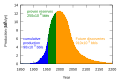 | |
|---|---|---|
| Results/responses | ||
| People | ||
| Books | ||
| Documentary films | ||
| Organizations | ||
| Other peaks | ||

The Permian Basin is a large sedimentary basin in the southwestern part of the United States. The basin contains the Mid-continent oil field province. This sedimentary basin is located in western Texas and southeastern New Mexico. It reaches from just south of Lubbock, past Midland and Odessa, south nearly to the Rio Grande River in southern West Central Texas, and extending westward into the southeastern part of New Mexico. It is so named because it has one of the world's thickest deposits of rocks from the Permian geologic period. The greater Permian Basin comprises several component basins; of these, the Midland Basin is the largest, Delaware Basin is the second largest, and Marfa Basin is the smallest. The Permian Basin covers more than 86,000 square miles (220,000 km2), and extends across an area approximately 250 miles (400 km) wide and 300 miles (480 km) long.

In geology, a rift is a linear zone where the lithosphere is being pulled apart and is an example of extensional tectonics. Typical rift features are a central linear downfaulted depression, called a graben, or more commonly a half-graben with normal faulting and rift-flank uplifts mainly on one side. Where rifts remain above sea level they form a rift valley, which may be filled by water forming a rift lake. The axis of the rift area may contain volcanic rocks, and active volcanism is a part of many, but not all, active rift systems.

The Mumbai High Field, formerly called the Bombay High Field, is an offshore oilfield 176 km (109 mi) off the west coast of Mumbai, in Gulf of Cambay region of India, in about 75 m (246 ft) of water. The oil operations are run by India's Oil and Natural Gas Corporation (ONGC).

North Sea oil is a mixture of hydrocarbons, comprising liquid petroleum and natural gas, produced from petroleum reservoirs beneath the North Sea.

The Statfjord oil field is a large oil and gas field covering 580 km2 in the U.K.-Norwegian boundary of the North Sea at a water depth of 145 m, discovered in 1974 by Mobil and since 1987 operated by Equinor.

The Maracaibo Basin, also known as Lake Maracaibo natural region, Lake Maracaibo depression or Lake Maracaibo Lowlands, is a foreland basin and one of the eight natural regions of Venezuela, found in the northwestern corner of Venezuela in South America. Covering over 36,657 square km, it is a hydrocarbon-rich region that has produced over 30 billion bbl of oil with an estimated 44 billion bbl yet to be recovered. The basin is characterized by a large shallow tidal estuary, Lake Maracaibo, located near its center. The Maracaibo basin has a complex tectonic history that dates back to the Jurassic period with multiple evolution stages. Despite its complexity, these major tectonic stages are well preserved within its stratigraphy. This makes The Maracaibo basin one of the most valuable basins for reconstructing South America's early tectonic history.

A passive margin is the transition between oceanic and continental lithosphere that is not an active plate margin. A passive margin forms by sedimentation above an ancient rift, now marked by transitional lithosphere. Continental rifting forms new ocean basins. Eventually the continental rift forms a mid-ocean ridge and the locus of extension moves away from the continent-ocean boundary. The transition between the continental and oceanic lithosphere that was originally formed by rifting is known as a passive margin.

The Sirte Basin is a late Mesozoic and Cenozoic triple junction continental rift along northern Africa that was initiated during the late Jurassic Period. It borders a relatively stable Paleozoic craton and cratonic sag basins along its southern margins. The province extends offshore into the Mediterranean Sea, with the northern boundary drawn at the 2,000 meter (m) bathymetric contour. It borders in the north on the Gulf of Sidra and extends south into northern Chad.
Fred F. Meissner was an American geologist and engineer who contributed to the fields of geology, geophysics, engineering, petroleum engineering, geochemistry, mineralogy, physics, mining, economic geology, and fishing.

Peter Alfred Ziegler was a Swiss geologist, who made contributions to the understanding of the geological evolution of Europe and the North Atlantic borderlands, of intraplate tectonics and of plate tectonic controls on the evolution and hydrocarbon potential of sedimentary basins. Ziegler's career consists of 33 years as exploration geologist with the petroleum industry, 30 of which with Shell, and 20 years of university teaching and research.

The Jeanne d'Arc Basin is an offshore sedimentary basin located about 340 kilometres to the basin centre, east-southeast of St. John's, Newfoundland and Labrador. This basin formed in response to the large scale plate tectonic forces that ripped apart the super-continent Pangea and also led to sea-floor spreading in the North Atlantic Ocean. This basin is one of a series of rift basins that are located on the broad, shallow promontory of continental crust known as the Grand Banks of Newfoundland off Canada's east coast. The basin was named after a purported 20 metres shoal labelled as "Ste. Jeanne d'Arc" on out-dated bathymetric charts and which was once thought to represent a local exposure of basement rocks similar to the Virgin Rocks.

Michael Christopher Daly (Mike),, is a British geologist, oil and gas executive and academic. BP’s global exploration chief for eight years, he retired in 2014 and became a visiting professor in Earth Sciences at the University of Oxford where he works on continental tectonics and resources.
Rabi Narayan Bastia is an Indian geoscientist and the Global Head of Exploration at Lime Petroleum, Norway, known for his contributions in the hydrocarbon explorations at Krishna Godavari Basin (2002), at Mahanadi Basin (2003) and at Cauvery (2007). A non-executive director of Asian Oilfield Services Limited and the President at OilMax Energy, Bastia is a recipient of the Odisha Living Legend Award. The Government of India awarded him the fourth highest civilian honour of the Padma Shri, in 2007, for his contributions to Science and Technology.
The Halibut Field is an oil field, within the Gippsland Basin offshore of the Australian state of Victoria. The oil field is located approximately 64 km offshore of southeastern Australia. The total area of this field is 26.9 km2 and is composed of 10 mappable units.

The Delta Field is located offshore from Nigeria on Oil Mining Leases (OML) 49 and 95. This is located within the Niger Delta Basin and sits in 12 feet of water. In 1965, the Delta 1 well was completed and the Delta Field opened in 1968 for production.

The Bolivar Coastal Fields (BCF), also known as the Bolivar Coastal Complex, is located on the eastern margin of Lake Maracaibo, Venezuela. Bolivar Coastal Field is the largest oil field in South America with its 6,000-7,000 wells and forest of related derricks, stretches thirty-five miles along the north-east coast of Lake Maracaibo. They form the largest oil field outside of the Middle East and contain mostly heavy oil with a gravity less than 22 degrees API. Also known as the Eastern Coast Fields, Bolivar Coastal Oil Field consists of Tía Juana, Lagunillas, Bachaquero, Ceuta, Motatán, Barua and Ambrosio. The Bolivar Coast field lies in the Maracaibo dry forests ecoregion, which has been severely damaged by farming and ranching as well as oil exploitation. The oil field still plays an important role in production from the nation with approximately 2.6 million barrels of oil a day. It is important to note that the oil and gas industry refers to the Bolivar Coastal Complex as a single oilfield, in spite of the fact that the oilfield consists of many sub-fields as stated above.

Hebron Oil Field, located off the coast of Newfoundland, is the fourth field to come on to production in the Jeanne d'Arc Basin. Discovered in 1981 and put online in 2017, the Hebron field is estimated to contain over 700 million barrels of producible hydrocarbons. The field is contained within a fault-bounded Mesozoic rift basin called the Jeanne d'Arc Basin.
Kapuni is an onshore natural gas-condensate field located in the Taranaki Basin, a ~100,000 km2 partially-inverted rift basin on the Taranaki Peninsula in the North Island, New Zealand. Discovered in 1959 and brought into production in 1970, Kapuni remained New Zealand's only producing gas-condensate field until the offshore Maui gas field began production in 1979.
In addition to terrestrial oil wells, Canada also extracts oil via offshore drilling.
The geology of the Norwegian Sea began to form 60 million years ago in the early Cenozoic, as rifting led to the eruption of mafic oceanic crust, separating Scandinavia and Greenland. Together with the North Sea the Norwegian Sea has become highly researched since the 1960s with the discovery of oil and natural gas in thick offshore sediments on top of the Norwegian continental shelf.