Gidhaur

Last updated

Gidhaur
Small Town
Minto Tower(Gidhaur).jpg
Minto Tower
India Bihar location map.svg
Red pog.svg
Gidhaur
Location in Bihar, India
Coordinates: 24°51′29″N86°18′01″E / 24.857941°N 86.300369°E / 24.857941; 86.300369
CountryFlag of India.svg  India
State Bihar
Region Angika
Division Munger
District Jamui
Elevation
26 m (85 ft)
Population
 (2011)
  Total9,353
Demonym Gidhauriya
Languages
  Official Hindi, Angika, Maithili Urdu
Time zone UTC+5:30 (IST)
PIN
811305
Telephone code06345
Vehicle registration BR46
Sex ratio 910/1000(2011) /
Lok Sabha constituency Jamui
Vidhan Sabha constituency Jhajha
Website

Gidhaur (also known as Patsanda) is a small town in the Jamui District of Bihar. In the early-modern period, it was the centre of the Gidhaur chieftaincy.

Contents

History

Raja Bir Bikram Shah who belonged to Chandel Rajput Dynasty founded this princely state in 1266 AD, after defeating the local leader Nagoria. [1] From here he started to expand his kingdom. He was the younger brother of Raja of Bardi From Singrauli. The Chandel Rajput rulers ruled over Gidhaur for more than six centuries. Raja Puran Mal, ninth in descent of this dynasty is said to have built the Baidyanath Dham temple at Deoghar in 1596. [2]

Patsanda was renamed Gidhaur by the name of railway station situated 2 kilometers from town. Gidhaur became a block in 1994, before which it was in Lakshmipur block.

Geography

Gidhaur is located at the bank of river Ulai, 167 kilometres south-east of state capital, Patna. It is situated at ( 24°52′0″N86°19′0″E / 24.86667°N 86.31667°E / 24.86667; 86.31667 ) about 19 kilometers east from the district headquarters Jamui.

Ulai is a monsoon river which flows parallel to the town and makes southern-western boundary. There are two hill Seva-Pahar and Bandhora-pahar in the direction of north and south of town.

The population is equally distributed around Minto tower. The town can be divided into eastern part (Jhajha side) and western side (Jamui side) in a way to categorize different local positions.

Demographics

The Patsanda village has a population of 9353, of which 4897 are males and 4456 are females, as per Population Census 2011. In Patsanda village population of children with age 0-6 is 1617 which makes up 17.29% of total population of village. The average sex ratio of Patsanda village is 910, which is lower than the Bihar state average of 918. The child sex ratio for the Patsanda as per census is 1011, higher than the Bihar average of 935. Patsanda village has a higher literacy rate than Bihar. In 2011, the literacy rate of Patsanda village was 67.72% compared to 61.80% in Bihar. In Patsanda the male literacy was 79.53% while the female literacy rate was 54.46%. [3]

Adjacent boundaries

Gidhaur Block

The geographical area of Gidhaur Block is 71.11 km2. Its population was 60,670 according to the census of 2011. There are twenty villages in Gidhaur block.

  • Bandhaura
  • Gangra
  • Kharhua
  • Mahuli
  • Ratanpur
 
  • Banjhulia
  • Genadih
  • Kolhua
  • Maura
  • Sansarpur
 
  • Chhatarpur
  • Guguldih
  • Kumardih
  • Nayagaon
  • Sewa
 
  • Dhobghat
  • Ketru Nawada
  • Kundhur
  • Patsanda
  • Simaria
  • Tardih
  • Sohjana

Economy

All the business premises are located in Gidhaur Bazaar centered around Minto tower. Earlier Local business shops were mainly in Tower chowk but now it is widely distributed. Most of the people depend on agriculture and small scale business for their livelihood.

Transportation

Rail

Gidhaur railway station Gidhaur railway station.jpg
Gidhaur railway station

Gidhaur lies on the Delhi–Howrah main railway line. The Gidhaur railway station (station code GHR) is 2 kilometers away from the center of town. Presently, ten express train and eight passenger train stops here. The railway station can be reached by auto-rickshaw and tumtum (horse-cart). Jhajha, a major railway station, connects Gidhaur to across the country.

Road

State Highway SH-18 passes through Gidhaur main market alongside Minto tower, connecting it to district headquarters Jamui and nearby major railway station Jhajha. The condition of the road has dramatically improved in last 5 years.

Ulai river bridge connects southern smaller villages to the town.

Air

There is a small helipad at Surendra Singh stadium which is used to land small helicopters.

Climate

Gidhaur has a humid subtropical climate with extremely hot summers from late March to early June, the monsoon season from late June to late September and a mild winter from November to February. In summer, Temperature rises to 45 °C and in winter It goes down to 5 °C. The table below details historical monthly averages for climate variables.

Climate data for Gidhaur
MonthJanFebMarAprMayJunJulAugSepOctNovDecYear
Average high °C (°F)23
(73)
26.1
(79.0)
32.4
(90.3)
37.4
(99.3)
38.4
(101.1)
36.7
(98.1)
32.9
(91.2)
32.5
(90.5)
32.2
(90.0)
31.7
(89.1)
28.9
(84.0)
24.6
(76.3)
31.4
(88.5)
Average low °C (°F)9.3
(48.7)
11.6
(52.9)
16.4
(61.5)
22.1
(71.8)
25.1
(77.2)
26.7
(80.1)
26.1
(79.0)
26.1
(79.0)
25.3
(77.5)
21.6
(70.9)
14.8
(58.6)
10.1
(50.2)
19.6
(67.3)
Average precipitation mm (inches)20.4
(0.80)
11.1
(0.44)
11.4
(0.45)
9
(0.4)
35.6
(1.40)
141
(5.6)
319.2
(12.57)
279.3
(11.00)
212.6
(8.37)
72.3
(2.85)
8.2
(0.32)
7.4
(0.29)
1,127.5
(44.49)
Source: worldweather.org [4]

Demographics

Total population of Gidhaur town is 7453 according to census of 2011. The male population is 4013 and the female population is 3440. [5]

Culture

Festivals

Durga Maa Gidhaur Durga.jpg
Durga Maa

Durga-puja of Gidhaur is very famous. It is celebrated with much fun-fare and religious way. A folk-line related to Durga-puja of Gidhaur is Kali hai kalkatte ki, Durga hai patsande ki, describes the popularity of it. Thousands of people visit Durga mandir in Navratri.

Laxmi Puja is celebrated after the fifth day of Dasami (the last day of Navratri). A month-long mela is held adjacent to Durga mandir to facilitate rural entertainment. A large variety of trees are sold, making this festival very environmentally friendly.

In addition to it, Holi, Diwali, Chhath puja, Eid, Muharram, and Ramnavmi are widely celebrated.

Sports

Gidhaur stadium Gidhaur stadium.jpg
Gidhaur stadium

Football is very popular and is played daily in Kumar Surendra Singh Stadium. Every year a major football tournament is organised. Cricket is also played by most children. There is a regional center of sports authority of India, where sportspersons train for athletics, volleyball, basketball, football etc.

Maharaja of Gidhaur Chandrachud Singh was a member of Bihar cricket team in one-day match played at Keenan Stadium Jamshedpur against English team Lord Tennyson's XI on 29 December 1937. [6]

Major public places

It is one of the few towns of district Jamui where basic governmental facilities like hospital, higher secondary school, public library, post office, police station, block office, stadium, and town hall are available.

Religious sites

Notable inhabitants

Related Research Articles

<span class="mw-page-title-main">Deoghar</span> City in Jharkhand, India

Deoghar is a major city in Jharkhand, India. It is a holy sacred place of Hinduism. The city is primarily known for Baidyanath Temple, one of the 12 Jyotirlingas of God Shiva. The sacred temples of the city make this a place for pilgrimage and tourists. The city is administrative headquarter of Deoghar District which comes under Santhal Parganas division of Jharkhand.

<span class="mw-page-title-main">Dumka</span> City in Jharkhand, India

Dumka, the headquarters of the Dumka district and Santhal Pargana region, is a city in the state of Jharkhand, India. It was made the headquarters of the Santhal Pargana region, which was carved out of the Bhagalpur and Birbhum district after the Santal Hool of 1855. Dumka was carved out of the southern part of Bihar along with 18 other Districts on 15 November 2000 to form Jharkhand as 28th State of India. Dumka is a peaceful and green city and also sub-capital of Jharkhand. The nearest important cities are Rampurhat and Deoghar.

Jamui is a town and a municipality in Jamui district in the Indian state of Bihar. It is the district headquarter of Jamui district. Jamui was formed as a district on 21 February 1991 as a result of its separation from Munger. It is part of Munger Division. The town is situated about 60km South-West of Munger.

<span class="mw-page-title-main">Jamui district</span> District of Bihar in India

Jamui is a district among 38 districts of Bihar state, India. The district was formed on 21 February 1991, when it was separated from Munger district. It is located at a longitude of 86° 13'E and the latitude is 24° 55'N.

<span class="mw-page-title-main">Banka district</span> District of Bihar in India

Banka is one of the thirty-eight districts of the state of Bihar in India. The district headquarters of Banka is situated in Banka town. The district was established on 21 February 1991.

<span class="mw-page-title-main">Dinhata</span> City in West Bengal, India

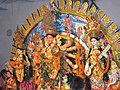
Dinhata is a city and a municipality in Cooch Behar district in the state of West Bengal, India. It is the headquarters of the Dinhata subdivision. Dinhata is known for arranging best Durga Puja in North Bengal. Dinhata is famous for Sastho Mela & Dinhata Utsav, Sanghati Mela, Janmastami Mela.

<span class="mw-page-title-main">Domjur</span> Census Town in West Bengal, India

Domjur is a census town in Domjur CD Block of Howrah Sadar subdivision in Howrah district in the Indian state of West Bengal. It is a part of Kolkata Urban Agglomeration.It is famous for its gold jewellery industries.

<span class="mw-page-title-main">Jasidih</span> Satellite Town in Jharkhand, India

Jasidih is a satellite town of Deoghar in the Deoghar subdivision of the Deoghar district in the Indian state of Jharkhand. This town's railway station connects Deoghar to other cities.

Jhajha is a city and a notified area in Jamui district in the Indian state of Bihar. It lies in the southern part of Bihar very close to the Jharkhand border. It falls on the Howrah - Mughalsarai mainline about halfway between Madhupur Junction and Kiul Junction.It is a very important and Main Market for the Nearby People and the city's People

<span class="mw-page-title-main">Rafiganj</span> Town in Bihar, India

Rafiganj is a town and a notified area in Aurangabad district in the Indian state of Bihar. It is the district's second-largest town in population after Aurangabad, and also the second-largest town in area. Rafiganj is located 25 km away from the District Administration.

Haveli Kharagpur is a town and One of the three subdivision in Munger district in the indian state of Bihar. Historically it was the centre of the medieval Kharagpur Raj chieftaincy.

<span class="mw-page-title-main">Digvijay Singh (Bihar politician)</span> Indian politician

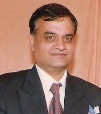
Digvijay Singh was an Indian politician from the state of Bihar, and an associate of George Fernandes of Janata Dal and later Samata Party, now led by Uday Mandal its President. He represented Banka in the Lok Sabha a few times. He was elected to Rajya Sabha twice. He died on 24 June 2010 in London after suffering a brain haemorrhage.

Jajuara, also written Jajuar and Yajuar, is the largest village in the Muzaffarpur district of Bihar in India, and the second-largest village in Bihar.

Bharaul is a small village situated in Bachhwara tehsil and located in Begusarai district of Bihar. It is one of 91 villages in Bachhwara Block along with villages like Rudauli and Arwa. Bharaul and Aagapur Kothi are on river-side of the Balan River opposite of each other. The nearest railway station from Bharaul is Bachhwara Junction which is 5.5 km away from the village. The main language of Bharaul is Maithili. Hindi is also spoken by most of the settlers. Bharaul village has a higher literacy rate compared to Bihar. In 2011, the literacy rate of Bharaul village was 63.64% compared to 61.80% of Bihar. In Bharaul, male literacy stood at 70.37% while female literacy rate was 56.45%.

Sihaul is a village with population of about 11,000 in the sub-district of Satar Kataiya, where it ranks as the third most populous village. The sub-district forms a part of Saharsa district in the state Bihar, India. The geographical area of the village is 9 km2 (3.5 sq mi) and it is the third biggest village by area in the sub-district. Population density of the village is 1287 persons per km2.

Sadiha is a village in Siwan district of Bihar, India. There is a nearby railway station named as sarhari railway station which comes under village sadiha. It is home to the Vishnudham Mandir temple and Kali Mandir Hanuman Mandir, Shiv Mandir and Chhath Ghat. Nearby markets include Patedha, Patedhi, Mora, Janta Bazar and Maharajganj. Durga Puja, Chhath Puja, Sarswati Puja, Holi, Diwali is there major festivals.

<span class="mw-page-title-main">Lohra, Bihar</span> Village in Bihar, India

Lohra Village Jamui district, state of Bihar in eastern India.

Bangomunda a tehsil located at about 95 km from Balangir in Titlagarh sub-division of Bolangir district, Odisha, India, has historical importance. Bangomunda is the new name of Banganmura which means Brinjal Firm.

Sono is a 'tehsil'/block in the Jamui district of the Indian state of Bihar. It lies in the southern part of Bihar very close to the Jharkhand border. Sono block is divided into 19 Gram panchayats.

<span class="mw-page-title-main">Gidhaur chieftaincy</span>

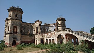
The Gidhaur Chieftaincy was a principality which controlled parts of South Bihar for much of the medieval period in India. The chieftaincy was named after the town of Gidhaur in Jamui district but its territory extended into the wider region.

References

  1. Ansari, Tahir Hussain (20 June 2019). Mughal Administration and the Zamindars of Bihar. Routledge. ISBN   978-1-000-65152-2.
  2. "Deoghar history".
  3. Patsanda, Overview. "Demographics". Census 2011. Retrieved 17 July 2015.
  4. "Climatological Information for Patna". World Weather. Retrieved 31 July 2013.
  5. "Population of Patsanda Village, Gidhaur, Bihar". populationofindia.co.in. Retrieved 18 February 2015.
  6. "The Home of CricketArchive". cricketarchive.com. Retrieved 18 February 2015.

https://en.m.wikipedia.org  › wiki Gidhaur chieftaincy