Glazier, Texas | |
|---|---|
 Glazier in the 1900s or 1910s | |
 Glazier  Glazier | |
| Coordinates: 36°0′49″N100°16′13″W / 36.01361°N 100.27028°W | |
| Country | United States |
| State | Texas |
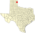
| County | Hemphill |
| Government | |
| Area | |
• Total | 1.29 sq mi (3.33 km2) |
| Elevation | 2,628 ft (801 m) |
| Population (2020) | |
• Total | 60 |
| • Density | 47/sq mi (18/km2) |
| Time zone | UTC-6 (Central (CST)) |
| • Summer (DST) | UTC-5 (CDT) |
| GNIS feature ID | 2805788 [1] |
Glazier is an unincorporated community and census-designated place (CDP) in Hemphill County, Texas, United States. It lies at the intersection of U.S. Highway 60 and State Highway 305, to the northeast of the city of Canadian, the county seat of Hemphill County. [2] Local addresses are served by the 79014 ZIP code of the post office in Canadian. [3] [4]
Contents
Every structure in Glazier except one house and the town's jail was destroyed by a violent tornado on April 9, 1947, and 17 people were killed. [5] [6] [7]
It is in the Canadian Independent School District. [8]