This article needs additional citations for verification .(January 2021) |

Glooscap 35 in Nova Scotia
Glooscap 35 is a Mi'kmaq reserve located in Kings County, Nova Scotia. [1]
It is administratively part of the Glooscap First Nation. [2]
This article needs additional citations for verification .(January 2021) |
Glooscap 35 is a Mi'kmaq reserve located in Kings County, Nova Scotia. [1]
It is administratively part of the Glooscap First Nation. [2]

The Annapolis Valley is a valley and region in the province of Nova Scotia, Canada. It is located in the western part of the Nova Scotia peninsula, formed by a trough between two parallel mountain ranges along the shore of the Bay of Fundy. Statistics Canada defines the Annapolis Valley as an economic region, composed of Annapolis County, Kings County, and Hants County.
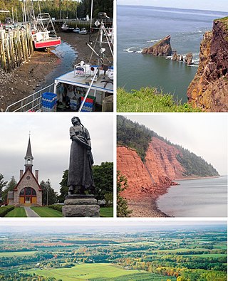
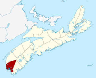
Kings County is a county in the Canadian province of Nova Scotia. With a population of 62,914 in the 2021 Census, Kings County is the third most populous county in the province. It is located in central Nova Scotia on the shore of the Bay of Fundy, with its northeastern part forming the western shore of the Minas Basin.
Yarmouth County is a rural county in the Canadian province of Nova Scotia. It has both traditional Anglo-Scottish and Acadian French culture as well as significant inland wilderness areas, including over 365 lakes and several major rivers. It comprises three municipalities: the Town of Yarmouth, the Municipality of the District of Yarmouth, and the Municipality of the District of Argyle.

Sunbury County is located in central New Brunswick, Canada. A large military base is located in the western part of the county south of the town of Oromocto. The county also hosts forestry and mixed farming. Burton is the county shire town.
Hantsport is an unincorporated area in the West Hants Regional Municipality, Nova Scotia, Canada. It is at the western boundary between West Hants Regional Municipality and Kings County, along the west bank of the Avon River's tidal estuary. The community is best known for its former industries, including shipbuilding, a pulp mill, as well a marine terminal that once loaded gypsum, mined near Windsor. The community is the resting place of Victoria Cross recipient William Hall.

Spencer's Island is a rural community in Cumberland County, Nova Scotia, located at the western end of Greville Bay on the Bay of Fundy. The community is named after a small island 45°19′50″N64°41′30″W of the same name located offshore from nearby Cape Spencer. According to local oral history, the island, cape and community trace their name to a man named Spencer who is buried on the island. However the name more likely comes from Lord Spencer, a British statesman at the time the community was settled.

Kings South is a provincial electoral district in Nova Scotia, Canada, that elects one member of the Nova Scotia House of Assembly. It includes the town of Wolfville, the village of New Minas, the community of Coldbrook, and Glooscap First Nation.
Cambridge is a community on the Cornwallis River in Kings County, Nova Scotia, Canada, located 12 kilometres west of Kentville. It is administratively part of the village of Cornwallis Square. According to one source, the community was named after Cambridge, England. while another holds it was named for Cambridge, Massachusetts.
The Fundy Shore Ecotour is a former scenic drive and network of tourist destinations in the Canadian province of Nova Scotia and encircles several sub-basins of the Bay of Fundy, which contains the highest tidal range on the planet.
West Apple River is the western side and main populated area of the Canadian rural community of Apple River, Nova Scotia in Cumberland County, Nova Scotia.
Beaver Harbour is a rural community on the Eastern Shore of Nova Scotia, Canada, in the Halifax Regional Municipality. It is located on the Marine Drive, along Trunk 7 approximately 11 km (6.8 mi) east of Sheet Harbour, Nova Scotia. The community is located on the shores of Beaver Harbour, an inlet of the Atlantic Ocean. The mi'kmaq name for the area was Kobelawakwemoode, translating to "beaver harbour". First Nations legends relay that a large rock in the harbour was thrown by Glooscap, a powerful figure in the First Nations' legends, at the mystical beaver. The land on which the community resides was part of a five thousand acre grant given to a surveyor on July 13, 1773. Five families lived here by the 1830s, and a post office was established in the community on October 1, 1887. A Trans-Atlantic cable station is located in the community, for the former CANTAT-2 cable.
Farrells River, formerly known as Parrsboro River, is a small river that flows south into an aboiteau on Parrsboro Harbour on the Minas Basin near the town of Parrsboro, Nova Scotia.

Brooklyn is a Canadian rural community located in western Hants County, Nova Scotia with a population of 916 people in 2016.
Pictou Landing First Nations is a Mi'kmaq First Nation band government in Nova Scotia, Canada. Their territory spans five reserves that have a combined area of 527.6 hectares. As of September 2017, the Mi'kmaq population is 485 on their own reserve, 23 on other reserves and 157 living off-reserve.
Loon Lake, could mean the following :
Cape Blomidon is a headland located on the Bay of Fundy coast of the Canadian province of Nova Scotia.

Glooscap First Nation is a Canadian Mi'kmaq aboriginal community located in both Kings County and Hants County, Nova Scotia. Also known as Kluskap, its reserve is located approximately 6.4 kilometres (4.0 mi) from the Town of Hantsport. Created in 1907 as Horton 35, the reserve encompasses some 171.1 hectares of rolling, mainly forested land. Forest management is practiced by the band. There is a variety store, gas bar, Greco Pizza, and gaming centre. There is also a health centre, youth centre and chapel. The Glooscap Landing Business Park is also owned by Glooscap First Nation which houses a second gas bar and Tim Hortons. The 2023 population was 434 people of whom approximately 100 lived on the reserve, making Glooscap the third-smallest First Nation community in Nova Scotia after Bear River First Nation and Annapolis Valley First Nation. Glooscap's population grew by 41% in one decade between 2013 and 2023.
Franklin Manor 22 is a Mi'kmaq reserve located in Cumberland County, Nova Scotia. It is administratively split between the Pictou Landing First Nation and the Paq'tnkek First Nation.
Annapolis Valley First Nation is composed of two Mi'kmaq First Nation reserves located in southwestern Nova Scotia. As of 2023, the Mi'kmaq population is 121 on-Reserve, and approximately 200 off-Reserve for a total population of 321. The community has a gas bar, tobacco shop, gaming centre, health centre, and a chapel. It is the smallest First Nation community in Nova Scotia in terms of population.
Paqtnkek Mi’kmaw Nation is a Mi'kmaq Band in northeastern Nova Scotia. Its populated reserve is Paqtnkek-Niktuek 23. As of December 2019 the total registered population was 598. It is a member of the Confederacy of Mainland Mi'kmaq. The name Paqtnkek means “by the bay” or "Above the water ". The area has long been important to Mi'kmaq for the fishing of eel and other species.
| Government & services | |||||
|---|---|---|---|---|---|
| Transportation | |||||
| Education |
| ||||
| Unincorporated Villages | |||||
45°02′33″N64°14′17″W / 45.04250°N 64.23806°W
| | This Kings County, Nova Scotia location article is a stub. You can help Wikipedia by expanding it. |