Cossatot River State Park-Natural Area is a 5,299.65-acre (2,144.69 ha) Arkansas state park in Howard County and Polk County, Arkansas in the United States. The park follows a rough, undeveloped 12.5 miles (20.1 km) of the Cossatot River. The river itself is included in Arkansas's Natural and Scenic Rivers System and the National Park Service's list of National Wild and Scenic Rivers, making it a whitewater rafting destination. The rough nature of the river, including Class III, IV, and dangerous Class V rapids, make the park-natural area a popular destination for skilled canoeists, kayakers, and playboaters. The park became a part of the system in 1988 after the Arkansas Department of Parks and Tourism and Arkansas Natural Heritage Commission agreed to cooperative management after acquiring the property from the Weyerhaeuser Corporation.

The New York – New Jersey Trail Conference (NYNJTC) is a volunteer-based federation of approximately 10,000 individual members and about 100 member organizations. The conference coordinates the maintenance of 2,000 miles of foot trails around the New York metropolitan area, from the Delaware Water Gap, north to beyond the Catskill Mountains, including the Appalachian Trail through New York and New Jersey. It also works to protect open space and publishes books and trail maps. The organization's headquarters are at 600 Ramapo Valley Road, Mahwah, New Jersey.

Beartown State Park is a 110-acre (45 ha) state park located on the eastern summit of Droop Mountain, 7 miles (11 km) southwest of Hillsboro, West Virginia, in northern Greenbrier County, West Virginia. The land was purchased in 1970 with funds from the Nature Conservancy and a donation from Mrs. Edwin G. Polan, in memory of her son, Ronald Keith Neal, a local soldier who was killed in the Vietnam War. Development of the park has been minimal in order to preserve the natural attractions of the area. Recreation in the park consists of hiking along improved trails and boardwalks. Markers explain the natural processes at work in the area. The name "Beartown State Park" was chosen because local residents claimed that many cave-like openings in the rocks made ideal winter dens for the native black bears, the state animal of West Virginia. Also because the many deep, narrow crevasses were formed in a regular criss-cross pattern which appear from above like the streets of a small town. Beartown is noted for its unusual rock formations, which consist of Droop, or Pottsville, Sandstone formed during the Pennsylvanian age. Massive boulders, overhanging cliffs and deep crevasses make up the beauty of the park. On the face of the cliffs are hundreds of eroded pits. These pits range from the size of a marble to others large enough to hold two grown men. It is not unusual to see ice and snow remaining in the deeper crevasses until midsummer.

Ouachita National Recreation Trail is a 223-mile (359 km) long, continuous hiking trail through the Ouachita Mountains of Oklahoma and Arkansas. It is the longest backpacking trail in the Ouachita National Forest, spanning 192 miles across its length. Approximately 177 miles of the trail is in Arkansas and 46 miles of the trail is in Oklahoma. The trail is used by hikers, backpackers, hunters, and mountain bikers. It is a non-motorized single track trail open only to foot traffic and partially open to mountain bicycles. Segments opened to mountain bikes are from the western terminus of the Ouachita Trail at Talimena State Park to the Big Cedar trailhead on US Highway 259 at approximately Mile Marker (MM) 30.5 in Oklahoma, and from the Talimena Scenic Drive Trailhead at MM 54.1, east to Highway 7 at mile 160.4, north of Jessieville, Arkansas.

Boiling Springs State Park is a park built 6 miles (9.7 km) northeast of Woodward, Oklahoma, USA. It was built by the Civilian Conservation Corps in the 1930s.
Greenleaf State Park is located near Braggs, Oklahoma, and is situated around the 930-acre (3.8 km2) Greenleaf Lake. Greenleaf Lake was built in 1939. There is an 18-mile (29 km) hiking trail that begins inside the park and makes its way around Greenleaf lake and into the adjacent government land of Camp Gruber.

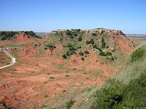
The Glass Mountains are not actually mountains, but a series of mesas and buttes that are part of the Blaine Escarpment that extends from the Permian red beds of northwestern Oklahoma in Major County. The Glass Mountains rise 150 feet (46 m) to 200 feet (61 m) above the surface of the plains, and the highest elevation in the formation is about 1,600 feet (490 m) above sea level. The Glass Mountains stretch west along U.S. Route 412 from Orienta south of the Cimarron River. The name comes from the sparkling selenite crystals on the slopes and tops of the mesas.

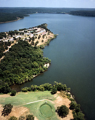
Quartz Mountain State Park is located in southwest Oklahoma at the western end of the Wichita Mountains, 13 miles (21 km) east of Mangum, Oklahoma and 20 miles (32 km) north of Altus, Oklahoma. The nearest community is Lone Wolf, Oklahoma, about 9 miles (14 km) northeast of the park. It is operated by Oklahoma State Park. The park began as a 158.3-acre tract adjacent to Lake Altus donated to the state by local residents, who had bought the land for $51.58. It was designated as Quartz Mountain State Park, one of the original seven Oklahoma State Parks designated in 1935. Additional land has been donated since then, and the park now encompasses 4,540 acres (18.4 km2). The park occupies land on the west side of Lake Altus-Lugert, which was originally built in 1927, then expanded in 1940 and renamed Lake Altus-Lugert. The park contains 4,284 acres (17.34 km2) of land and more than 6,000 acres (24 km2) of water.
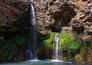
Natural Falls State Park is a 120 acres (0.49 km2) state-owned park in the Ozarks, in Delaware County, Oklahoma. It lies along U.S. Highway 412, near the Arkansas-Oklahoma state line. The property was privately-owned and known as Dripping Springs until 1990, when the state bought it. The previous owners had also used the property as an attraction and rest stop for travelers on the highway, featuring a swimming pool and gardens. The site was used in the production of the 1974 film "Where the Red Fern Grows".

The Deschutes River State Recreation Area is a park at the confluence of the Deschutes and Columbia rivers in the U.S. state of Oregon. It is a few miles east of The Dalles. The 35.1-acre (14.2 ha) park offers opportunities for camping, fishing, hiking, mountain biking, and equestrian trail riding.

The former Arrowhead State Park, now known as the Arrowhead Area at Lake Eufaula State Park is a 2,200-acre (8.9 km2) Oklahoma state park area located in northern Pittsburg County, Oklahoma on a peninsula of Eufaula Lake. It is located near the city of Canadian, Oklahoma. Eufaula is one of the largest man-made lakes in the southwest. Arrowhead State Park features 100 tent sites and 91 total RV sites. The park also offers picnic shelters, a marina, playgrounds, trails, miniature golf course, swimming area, mountain biking, equestrian campground, stables, and 25 miles (40 km) of equestrian trails. Group camps with a kitchen and bunkhouses are available and can sleep up to 144 people. Area 51 Marina, which also offers a restaurant, is also located at the park in the Echo Ridge area.
Foss State Park is a 1,749-acre (708 ha) Oklahoma state park located on Foss Lake, in southwestern Custer County, Oklahoma, near the city of Foss.

Great Plains State Park is a 487-acre (1.97 km2) Oklahoma state park located in Kiowa County, Oklahoma. The part of the park that is developed for campers and hikers is about 487 acres. However, the entire park encompasses more than 1,200 acres from one end to the other. It is located near the city of Mountain Park, Oklahoma. Located south of Hobart off Hwy 183, Great Plains State Park is nestled between the Wichita Mountains and the Tom Steed Reservoir. The area offers water sports, boating, boat ramps, camping, RV parking, swimming beach, playground, picnic areas, cycling, mountain biking and hiking trails. The campground spans approximately 460 acres (1.9 km2) of park land with 56 RV hookups and 30 tent sites. RV sites consist of 14 modern water, sewer, and electric sites and 42 semi-modern sites with water and electric. Located on the shores of Tom Steed Reservoir, a large lake with 31 miles (50 km) of shoreline.

Great Salt Plains State Park is a 840-acre (3.4 km2) Oklahoma state park located in Alfalfa County, Oklahoma. It is located 8 miles (13 km) north of Jet, Oklahoma on SH-38 and 12 miles (19 km) east of Cherokee. Recreational opportunities at Great Salt Plains State Park include boating, camping, picnicking, swimming, hiking, mountain biking and exploring. The Great Salt Plains Lake is located at the park and covers 9,300 acres (38 km2) with 41 miles (66 km) of shoreline and is a shallow, salty lake with fishing opportunities for catfish, saugeye, sandbass and hybrid striper. The average depth is reportedly 4 feet (1.2 m) and the impoundment capacity is 31,420 acre-feet. Salinity of the water in the reservoir is one-fourth that of sea water. Personal watercraft are not recommended. The park has RV and tent sites, comfort stations with showers, cabins, picnic sites, group shelters, swimming beach, playgrounds, boat ramps, fishing dock and equestrian trails. Horse rental is not available.
Mayo River State Park is a North Carolina state park in Rockingham County, North Carolina in the United States. It covers 2,778-acre (11.24 km2) along the Mayo River, and it adjoins a Virginia State Park of the same name. North Carolina's park is near Mayodan, North Carolina. The park is one of the newest in the North Carolina system, having been authorized by the General Assembly in May 2003.

Lost Dutchman State Park is a 320-acre (129 ha) state park located in northwestern Pinal County, Arizona on the Apache Trail north of Apache Junction, near the Superstition Mountains in central Arizona. It is named after the Lost Dutchman's Gold Mine, a famously lost gold mine legendary in the tales of the Old West. It is accessible about 40 miles (64 km) east of Phoenix via U.S. Highway 60, the Superstition Freeway.

Hobbs State Park – Conservation Area is a 12,056-acre (4,879 ha) Arkansas state park in Benton, Carroll, and Madison Counties, Arkansas in the United States. The park was bought in 1979 through a huge financial effort from Northwest Arkansas banks. Hobbs State Park – Conservation Area is located almost entirely in the Springfield Plateau subdivision of the Ozark Plateau. The park, located just south of Beaver Lake, is open for year-round recreation, including 32.9 miles (52.9 km) of hiking, mountain bike and equestrian trails. Hobbs State Park – Conservation Area also has several picnic areas, a shooting range, and primitive camping sites.
Sequoyah State Park, one of Oklahoma State Park's 32 parks, is a 2,200 acre peninsular recreation space on the eastern shore of Fort Gibson Lake in Cherokee County, Oklahoma. It is 8 miles (13 km) east of Wagoner, Oklahoma and 18 miles (29 km) west of Tahlequah, Oklahoma on State Highway 51. A shortleaf pine-lined drive leads you to the many amenities of the park including camping loops, Paradise Cove Marina, a golf course, Three Forks Nature Center, Sequoyah Riding Stables, and the state's largest state park lodge. There are 12 miles of hiking trails free and open to the public including the Fossil Trail, Bluebird Trail, and Scissortail Paved Trail.
Walnut Creek State Park was a former Oklahoma State Park on the north shore of Lake Keystone, 4 miles (6.4 km) west of Prue in Osage County, Oklahoma. The park was created in 1966, and contains 1,400 acres. Facilities include sandy beaches, a softball field, picnic shelter with tables, RV hookups, and tent sites and restrooms. The 15 miles (24 km) long Sand Plum Trail is open to hikers, horseback riders, and mountain bikers. The park has an equestrian campground, but visitors must bring their own horses because horses are not available for rent in the park. The park was open all year.

Cottonwood Canyon State Park, established in 2013, is the second largest state park in Oregon, encompassing 8,000 acres (3,200 ha) on the lower John Day River. The largest is Silver Falls State Park at 9,064 acres (3,668 ha).