Little River National Wildlife Refuge

Last updated
Little River National Wildlife Refuge
IUCN category IV (habitat/species management area)
Little river nwr cypress slough.jpg
Usa edcp relief location map.png
Red pog.svg
Map of the United States
Location McCurtain County, Oklahoma, United States
Nearest city Idabel, Oklahoma
Coordinates 33°56′47″N94°46′21″W / 33.94639°N 94.77250°W / 33.94639; -94.77250 Coordinates: 33°56′47″N94°46′21″W / 33.94639°N 94.77250°W / 33.94639; -94.77250
Area15,000 acres (61 km2)
Established1987
Governing body U.S. Fish and Wildlife Service
Website Little River National Wildlife Refuge

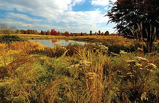
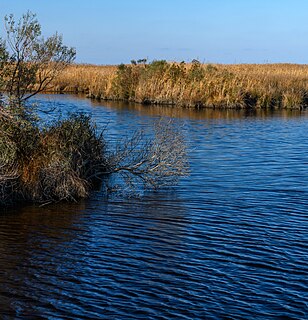
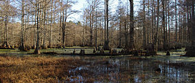
The Little River National Wildlife Refuge is a National Wildlife Refuge of the United States located in Oklahoma. It covers 15,000 acres (61 km2) of forests and wetlands.

National Wildlife Refuge type of federal conservation area in the United States

National Wildlife RefugeSystem is a designation for certain protected areas of the United States managed by the United States Fish and Wildlife Service. The National Wildlife Refuge System is the system of public lands and waters set aside to conserve America's fish, wildlife, and plants. Since President Theodore Roosevelt designated Florida's Pelican Island National Wildlife Refuge as the first wildlife refuge in 1903, the system has grown to over 562 national wildlife refuges and 38 wetland management districts encompassing more than 150,000,000 acres (607,028 km2).

United States Federal republic in North America

The United States of America (USA), commonly known as the United States or America, is a country comprising 50 states, a federal district, five major self-governing territories, and various possessions. At 3.8 million square miles, the United States is the world's third or fourth largest country by total area and is slightly smaller than the entire continent of Europe's 3.9 million square miles. With a population of over 327 million people, the U.S. is the third most populous country. The capital is Washington, D.C., and the largest city by population is New York City. Forty-eight states and the capital's federal district are contiguous in North America between Canada and Mexico. The State of Alaska is in the northwest corner of North America, bordered by Canada to the east and across the Bering Strait from Russia to the west. The State of Hawaii is an archipelago in the mid-Pacific Ocean. The U.S. territories are scattered about the Pacific Ocean and the Caribbean Sea, stretching across nine official time zones. The extremely diverse geography, climate, and wildlife of the United States make it one of the world's 17 megadiverse countries.

Oklahoma State of the United States of America

Oklahoma is a state in the South Central region of the United States, bordered by Kansas on the north, Missouri on the northeast, Arkansas on the east, Texas on the south, New Mexico on the west, and Colorado on the northwest. It is the 20th-most extensive and the 28th-most populous of the fifty United States. The state's name is derived from the Choctaw words okla and humma, meaning "red people". It is also known informally by its nickname, "The Sooner State", in reference to the non-Native settlers who staked their claims on land before the official opening date of lands in the western Oklahoma Territory or before the Indian Appropriations Act of 1889, which dramatically increased European-American settlement in the eastern Indian Territory. Oklahoma Territory and Indian Territory were merged into the State of Oklahoma when it became the 46th state to enter the union on November 16, 1907. Its residents are known as Oklahomans, and its capital and largest city is Oklahoma City.

The refuge contains most of the remaining bottomland hardwood communities in the southeastern part of the state. It is characterized by low, wet oak and hickory forest with oxbows and sloughs. Trees of the landscape include hickory, willow oak, sweetgum, cypress, white oak, loblolly pine, and walnut.

Hardwood wood from angiosperm trees

Hardwood is wood from dicot trees. These are usually found in broad-leaved temperate and tropical forests. In temperate and boreal latitudes they are mostly deciduous, but in tropics and subtropics mostly evergreen. Hardwood contrasts with softwood.

Oak genus of plants

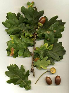
An oak is a tree or shrub in the genus Quercus of the beech family, Fagaceae. There are approximately 600 extant species of oaks. The common name "oak" also appears in the names of species in related genera, notably Lithocarpus, as well as in those of unrelated species such as Grevillea robusta and the Casuarinaceae (she-oaks). The genus Quercus is native to the Northern Hemisphere, and includes deciduous and evergreen species extending from cool temperate to tropical latitudes in the Americas, Asia, Europe, and North Africa. North America contains the largest number of oak species, with approximately 90 occurring in the United States, while Mexico has 160 species of which 109 are endemic. The second greatest center of oak diversity is China, which contains approximately 100 species.

Hickory genus of plants

Hickory is a type of tree, comprising the genus Carya. The genus includes 17 to 19 species. Five or six species are native to China, Indochina, and India (Assam), as many as 12 are native to the United States, four are found in Mexico, and two to four are from Canada. A number of hickory species are used for products like edible nuts or wood.

A map of the Little River National Wildlife Refuge. Little River National Wildlife Refuge, Oklahoma.jpg
A map of the Little River National Wildlife Refuge.

Related Research Articles

Marais des Cygnes National Wildlife Refuge

Marais des Cygnes National Wildlife Refuge (NWR) is located in Linn County, Kansas along the Marais des Cygnes River. The 7,500 acre (30 km2) Refuge was established in 1992 to protect one of the northwestern-most examples of bottomland hardwood forest in the United States as well as the largest contiguous tract of bottomland hardwood forest in Kansas. Marais des Cygnes means "marsh of swans" in French.

Deep Fork National Wildlife Refuge

The Deep Fork National Wildlife Refuge (DFNWR) is part of the United States system of National Wildlife Refuges, and is a critical resource for wildfowl that migrate along the Central Flyway in Spring and Fall. It is located in Eastern Oklahoma, near the city of Okmulgee. The preserve runs along both banks of the Deep Fork River for about 20 miles (32 km). According to TravelOK, DFNWR receives about 45,000 visitors every year.

Appalachian mixed mesophytic forests ecoregion in the eastern United States

The Appalachian mixed mesophytic forests is an ecoregion of the temperate broadleaf and mixed forests biome, as defined by the World Wildlife Fund. It consists of mesophytic plants west of the Appalachian Mountains in the Southeastern United States.

Necedah National Wildlife Refuge

Necedah National Wildlife Refuge is a 43,696-acre (176.83 km2) National Wildlife Refuge located in northern Juneau County, Wisconsin near the village of Necedah. It was established in 1939 and is famous as the northern nesting site for reintroduction of an eastern United States population of the endangered whooping crane.

Appalachian-Blue Ridge forests

The Appalachian-Blue Ridge forests is an ecoregion in the Temperate broadleaf and mixed forests Biome, in the Eastern United States. The ecoregion is located in the central and southern Appalachian Mountains, including the Ridge-and-Valley Appalachians and the Blue Ridge Mountains. It covers an area of about 61,500 square miles (159,000 km2) in: northeast Alabama and Georgia, northwest South Carolina, eastern Tennessee, western North Carolina, Virginia, Maryland, and central West Virginia and Pennsylvania; and small extensions into Kentucky, New Jersey, and New York.

Cypress Creek National Wildlife Refuge

The Cypress Creek National Wildlife Refuge is located in the Cache River watershed in southernmost Illinois, largely in Pulaski County, but with extensions into Union, Alexander, and Johnson counties. The refuge was established in 1990 under the authority of the Emergency Wetlands Resources Act of 1986. The refuge protects over 16,000 acres (65 km2) of the Cache River wetlands, and has a purchase boundary of 36,000 acres (146 km²) contiguous.

Elizabeth Hartwell Mason Neck National Wildlife Refuge

Elizabeth Hartwell Mason Neck National Wildlife Refuge is a National Wildlife Refuge of the United States located in Virginia. It is part of the Potomac River National Wildlife Refuge Complex. It is on Mason Neck, a peninsula in the Potomac River that forms part of the shoreline of Belmont Bay. The refuge is adjacent to Mason Neck State Park.

Occoquan Bay National Wildlife Refuge

The Occoquan Bay National Wildlife Refuge is a National Wildlife Refuge located where the Occoquan River meets the Potomac River in Woodbridge, Virginia, United States. The 644-acre (2.61 km2) site, about half of which is wetlands, was a popular tourist spot known as Dawson Beach until the 1940s, after which it was used for military research by the U.S. Army's Harry Diamond Laboratories from the 1960s to the 1990s. When the land was purchased from the military, it was temporarily called the Marumsco National Wildlife Refuge. The refuge was formally established and renamed in 1998, and is now managed by the United States Fish and Wildlife Service as part of the Potomac River National Wildlife Refuge Complex.

Black Bayou Lake National Wildlife Refuge

Black Bayou Lake National Wildlife Refuge is one of five refuges managed in the North Louisiana Refuge Complex and one of 545 refuges in the National Wildlife Refuge System. It was established in 1997 through a unique partnership with the city of Monroe, Louisiana. The U.S. Fish and Wildlife Service has a free 99-year lease to manage the city-owned lake.

Logan Cave National Wildlife Refuge

Logan Cave National Wildlife Refuge in Benton County, Arkansas became the 455th National Wildlife Refuge on March 14, 1989 under the Endangered Species Act of 1973. This 123-acre (0.50 km2) Ozark Mountain refuge, which includes a limestone-solution cave, is located 20 miles (32 km) west of Fayetteville, Arkansas and approximately 2 miles (3.2 km) north of U.S. Highway #412.

Clarks River National Wildlife Refuge

Clarks River National Wildlife Refuge is a bottomland hardwood forest located in western Kentucky near Benton. The refuge lies along the East Fork of the Clarks River and is seasonal home to over 200 different species of migratory birds. The bottom lands are dominated with overcup oaks, bald cypress, and tupelo-gum, and the slightly higher, better drained areas are covered with willow oak, swamp chestnut oak, red oak, sweet gum, sycamore, ash and elm.

Massasoit National Wildlife Refuge

Massasoit National Wildlife Refuge was established in 1983 to conserve the federally endangered Plymouth Red-bellied Turtle, as well as other wildlife and plant species. The Refuge encompasses 195 acres (0.79 km2) in Plymouth, Massachusetts. It is made up of two parcels; the Crooked Pond parcel abuts the Myles Standish State Forest, the second largest State forest in Massachusetts, and the smaller parcel is located on the shoreline of Island Pond. Massasoit National Wildlife Refuge is located within a 3,269-acre (13.23 km2) area designated as critical habitat for the Plymouth Red-bellied Turtle.

Panther Swamp National Wildlife Refuge

Panther Swamp National Wildlife Refuge is one of seven refuges in the Theodore Roosevelt National Wildlife Refuge Complex in Mississippi. Established in 1978, Panther Swamp National Wildlife Refuge encompasses 38,697 acres (156.60 km2). Included in those acres is one of the largest blocks of bottomland forest in the lower Mississippi River alluvial floodplain. The upland areas or ridges often crest at no more than one foot above swamp areas, and contain nuttall, willow and water oaks and other species while overcup oak, bitter pecan and ash dominate the transition zone from swamp to upland. Additional habitat types consist of reforested and agricultural areas.

Conscience Point National Wildlife Refuge

The Conscience Point National Wildlife Refuge was established July 20, 1971 as a land gift from Stanley Howard. The 60-acre (24 ha) refuge is located in the hamlet of North Sea on the north shore of Long Island's south fork. The refuge protects grasslands, oak-beech forest, shrub habitats, kettle holes, freshwater marsh and salt marsh.

Elizabeth A. Morton National Wildlife Refuge

The Elizabeth A. Morton National Wildlife Refuge is a 187-acre (76 ha) National Wildlife Refuge in Noyack, New York. Much of the refuge is situated on a peninsula surrounded by Noyack and Little Peconic bays. The refuge is managed by the United States Fish and Wildlife Service as part of the Long Island National Wildlife Refuge Complex.

Target Rock National Wildlife Refuge

The Target Rock National Wildlife Refuge is located just east of the village of Lloyd Harbor, New York, on the north shore of Long Island, 25 miles (40 km) east of New York City. It is managed by the U.S. Fish and Wildlife Service as part of the Long Island National Wildlife Refuge Complex.

Mackay Island National Wildlife Refuge

Mackay Island National Wildlife Refuge was established in 1960 to provide habitat for migratory waterfowl, primarily the greater snow goose. It is located almost entirely on Knotts Island in the Currituck Sound between Back Bay in Virginia Beach, Virginia and the open sound in North Carolina. Most of the refuge lies within North Carolina but some of it is in Virginia. The refuge is primarily made up of marsh habitat. This area has long been recognized for supporting significant migratory waterfowl populations and sport fishery resources, and is part of the Charles Kuralt Trail.

San Joaquin River National Wildlife Refuge

The San Joaquin River National Wildlife Refuge is a protected area of along the San Joaquin River in the northern San Joaquin Valley, California. It is within San Joaquin County and Stanislaus County

Mississippi lowland forests

The Mississippi lowland forests are a temperate broadleaf and mixed forest ecoregion in the eastern United States, covering an area of 112,300 km2 (43,400 sq mi).

Southeastern mixed forests

The Southeastern mixed forests are an ecoregion of the temperate broadleaf and mixed forest biome, in the lower portion of the Eastern United States.

References

PD-icon.svg This article incorporates  public domain material from websites or documents ofthe United States Fish and Wildlife Service .

United States Fish and Wildlife Service US Federal Government agency

The United States Fish and Wildlife Service is an agency of the US Federal Government within the US Department of the Interior dedicated to the management of fish, wildlife, and natural habitats. The mission of the agency is "working with others to conserve, protect, and enhance fish, wildlife, plants and their habitats for the continuing benefit of the American people."