Washita National Wildlife Refuge

Last updated
Washita National Wildlife Refuge
IUCN category IV (habitat/species management area)
Oklahoma sunset washita nwr.jpg
Sunset at Washita NWR. 22 November 2013. Courtesy U.S. Fish & Wildlife Service
Usa edcp relief location map.png
Red pog.svg
Map of the United States
Location Custer County, Oklahoma, United States
Nearest city Butler, Oklahoma<"EOHC-WNWR">
Coordinates 35°36′30″N99°15′02″W / 35.60838°N 99.25065°W / 35.60838; -99.25065 [1] Coordinates: 35°36′30″N99°15′02″W / 35.60838°N 99.25065°W / 35.60838; -99.25065 [2]
Area8,075 acres (32.68 km2)
Established1961<"EOHC-WNWR"/>
Governing body U.S. Fish and Wildlife Service
Website Washita National Wildlife Refuge

Washita National Wildlife Refuge is a National Wildlife Refuge (NWR) of the United States located in Custer County, Oklahoma. Created in 1961 on the shore of Foss Lake, it was the fourth NWR in the state. It is 5 miles (8.0 km) west of Butler, Oklahoma. [3]

National Wildlife Refuge type of federal conservation area in the United States

National Wildlife RefugeSystem is a designation for certain protected areas of the United States managed by the United States Fish and Wildlife Service. The National Wildlife Refuge System is the system of public lands and waters set aside to conserve America's fish, wildlife, and plants. Since President Theodore Roosevelt designated Florida's Pelican Island National Wildlife Refuge as the first wildlife refuge in 1903, the system has grown to over 562 national wildlife refuges and 38 wetland management districts encompassing more than 150,000,000 acres (607,028 km2).

United States Federal republic in North America

The United States of America (USA), commonly known as the United States or America, is a country comprising 50 states, a federal district, five major self-governing territories, and various possessions. At 3.8 million square miles, the United States is the world's third or fourth largest country by total area and is slightly smaller than the entire continent of Europe's 3.9 million square miles. With a population of over 327 million people, the U.S. is the third most populous country. The capital is Washington, D.C., and the largest city by population is New York City. Forty-eight states and the capital's federal district are contiguous in North America between Canada and Mexico. The State of Alaska is in the northwest corner of North America, bordered by Canada to the east and across the Bering Strait from Russia to the west. The State of Hawaii is an archipelago in the mid-Pacific Ocean. The U.S. territories are scattered about the Pacific Ocean and the Caribbean Sea, stretching across nine official time zones. The extremely diverse geography, climate, and wildlife of the United States make it one of the world's 17 megadiverse countries.

Custer County, Oklahoma County in the United States

Custer County is a county located in the U.S. state of Oklahoma. As of the 2010 census, the population was 27,469. Its county seat is Arapaho. The county was named in honor of General George Armstrong Custer.

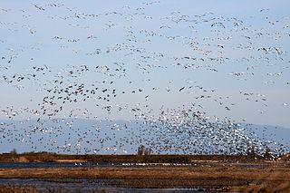
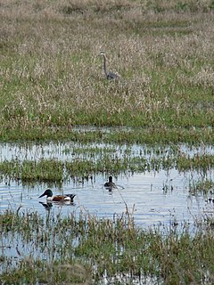
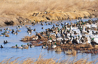
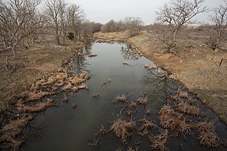
Within the refuge, the slow-moving Washita River winds through prairie and cropland to merge with Foss Reservoir, providing a home and resting area for geese and other waterfowl. Gently rolling hills, ravines, and bottomlands laced with creeks shelter wildlife as common as white-tailed deer and as unusual as the Texas horned lizard, a state-listed endangered species.

Washita River river in the United States of America

The Washita River is a river in the states of Texas and Oklahoma in the United States. The river is 295 miles (475 km) long and terminates at its confluence with the Red River, which is now part of Lake Texoma on the Texas–Oklahoma border.

Prairie ecosystems considered part of the temperate grasslands, savannas, and shrublands biome

Prairies are ecosystems considered part of the temperate grasslands, savannas, and shrublands biome by ecologists, based on similar temperate climates, moderate rainfall, and a composition of grasses, herbs, and shrubs, rather than trees, as the dominant vegetation type. Temperate grassland regions include the Pampas of Argentina, Brazil and Uruguay, and the steppe of Ukraine, Russia and Kazakhstan. Lands typically referred to as "prairie" tend to be in North America. The term encompasses the area referred to as the Interior Lowlands of Canada, the United States, and Mexico, which includes all of the Great Plains as well as the wetter, hillier land to the east.

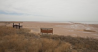
Foss Reservoir, also known as Foss Lake, is in Custer County, Oklahoma on the Washita River, about 15 miles (24 km) west of Clinton, Oklahoma. The reservoir was constructed during 1958–1961 by the U. S. Bureau of Reclamation. The project was known originally as the Washita Basin Project. The lake and dam were named for the community of Foss, Oklahoma, about 6 miles (9.7 km) south of the site. The primary purposes are to regulate flow of the river and to provide water for the cities of Bessie, Clinton, Cordell and Hobart. It is western Oklahoma's largest lake and lies entirely within Foss State Park.

The United States Fish and Wildlife Service has reported 270 bird species as having been seen in the NWR. These include occasional sightings of the bald eagle and rare sightings of whooping cranes. Outdoor activities allowed in the NWR include birdwatching, boating, hiking, fishing, and limited hunting. Hunting is allowed only in certain seasons and with special permits. Quarry includes deer, geese, sandhill cranes, quail, and rabbits. [3]


Related Research Articles

Bald Knob National Wildlife Refuge

The Bald Knob National Wildlife Refuge is a 15,022 acres (60.79 km2) (2014) wildlife refuge located in White County, Arkansas about two miles south of the town of Bald Knob. The refuge is managed by the United States Fish and Wildlife Service. The refuge features large numbers of migratory waterfowl and bald eagles during the winter months.

Sacramento National Wildlife Refuge Complex

The Sacramento National Wildlife Refuge Complex is part of the United States system of National Wildlife Refuges (NWR). It is located in northern California, in the valley of the Sacramento River.

Flint Hills National Wildlife Refuge

Flint Hills National Wildlife Refuge (NWR) is a wildlife refuge located north and east of the city of Hartford, Kansas, United States, in northwestern Coffey and southeastern Lyon Counties. It was established in 1966 as part of the U.S. Army Corps of Engineers, John Redmond Reservoir flood control project. The U.S. Fish and Wildlife Service manages 18,463 acres (75 km²) upstream of the reservoir, most of which is in the floodplain of the Neosho River. Refuge habitats, consisting of prairie grasslands, bottomland hardwood timber, shallow wetlands, and croplands, are managed to provide food and habitat for migratory birds and resident wildlife.

Tishomingo National Wildlife Refuge

The Tishomingo National Wildlife Refuge is a National Wildlife Refuge of the United States located in Oklahoma. It is in southern Johnston and northeastern Marshall Counties in the eastern part of the state, near the upper Washita arm of Lake Texoma.

Salt Plains National Wildlife Refuge

The Salt Plains National Wildlife Refuge is part of the United States system of National Wildlife Refuges. It is located in Alfalfa County in northern Oklahoma, north of Jet, along Great Salt Plains Lake, which is formed by a dam on the Salt Fork of the Arkansas River.

Ridgefield National Wildlife Refuge American wildlife preserve

Ridgefield National Wildlife Refuge is a wildlife preserve, one of the national wildlife refuges operated by the United States Fish and Wildlife Service, located in the westernmost part of Clark County, Washington. The refuge protects more than 5,200 acres (2,100 ha) of marshes, grasslands, and woodlands. The refuge was established in 1965, in response to a need to establish vital winter habitat for wintering waterfowl with an emphasis on the dusky Canada goose whose nesting areas in Alaska were severely impacted by the violent earthquake of 1964.

Benton Lake National Wildlife Refuge

Benton Lake National Wildlife Refuge is a 12,459-acre (5,042 ha) National Wildlife Refuge (NWR) in the central part of the U.S. state of Montana. It lies in northern Cascade County, 12 mi (19 km) north of the city of Great Falls, Montana. Benton Lake NWR includes shortgrass prairie and seasonal wetlands, and is nearly surrounded by the Highwood Mountains to the east, Big Belt Mountains to the south, and the Rocky Mountains to the west. Benton Lake NWR is on the western edge of the northern Great Plains and much of the shallow lake is a 6,000-acre (2,400 ha) wetland.

Bowdoin National Wildlife Refuge

Bowdoin National Wildlife Refuge is a 15,551-acre (6,293 ha) National Wildlife Refuge (NWR) located in the north-central region of the U.S. state of Montana. The refuge is 7 mi (11 km) northeast of Malta, Montana in the Milk River Valley and is managed by the U.S. Fish and Wildlife Service.

Seney National Wildlife Refuge

The Seney National Wildlife Refuge is a managed wetland in Schoolcraft County in the U.S. state of Michigan. It has an area of 95,212 acres (385 km2). It is bordered by M-28 and M-77. The nearest town of any size is Seney, Michigan. The refuge contains the Seney Wilderness Area and the Strangmoor Bog National Natural Landmark within its boundaries.

Lacreek National Wildlife Refuge

Lacreek National Wildlife Refuge is a National Wildlife Refuge of the United States located in South Dakota. It covers 16,410 acres (66.4 km2) and is managed by the United States Fish and Wildlife Service.

Karl E. Mundt National Wildlife Refuge

Karl E. Mundt National Wildlife Refuge is located mostly in the southern part of the U.S. state of South Dakota, with a small extension into northern Nebraska, and includes 1,085 acres (4.39 km2) The refuge is a part of the Lake Andes National Wildlife Refuge Complex and is managed by the U.S. Fish and Wildlife Service. Of the land area in the district, the U.S. Government owns only 780 acres (3.15 km2), while the remaining area is managed as an easement. The refuge is closed to the public but there are excellent viewing locations from the Ft. Randle Dam on the Missouri River. The Karl E. Mundt NWR has the largest concentration of bald eagles in the lower 48 states, with over 200 eagles often spending the winter on the refuge. The refuge was named for former South Dakota Senator Karl Mundt, who was a strong supporter of the Endangered Species Act of 1966.

Erie National Wildlife Refuge

The Erie National Wildlife Refuge is an 8,777-acre (3,552 ha) National Wildlife Refuge located in Crawford County, Pennsylvania. Named after the Erie tribe, it was established to provide waterfowl and other migratory birds with nesting, feeding, brooding, and resting habitat.

Arrowwood National Wildlife Refuge

Arrowwood National Wildlife Refuge is located in the U.S. state of North Dakota. Arrowwood NWR is a part of the Arrowwood National Wildlife Refuge Complex, and is managed by the U.S. Fish and Wildlife Service. The refuge parallels 16 miles (27 km) of the James River and is a mixture of wetlands, forest and prairie. Efforts to ensure the refuge continues to provide prime nesting habitat for waterfowl include prescribed fire, haying, crop cultivation and livestock grazing. The refuge has forests with oak and hackberry which are uncommon on the prairie. It is believed that the name for the refuge is derived from Native American naming for arrow wood, as the wood in the forest was prized for the making of arrows.

Rydell National Wildlife Refuge

The Rydell National Wildlife Refuge is an 2,120-acre (9 km2) National Wildlife Refuge in northwestern Minnesota, located in Woodside Township, Polk County, just west of Erskine in northwestern Minnesota. It was established in 1992, and receives more than 7,800 visitors each year. The refuge is a combination of maple/basswood/oak forest, wetlands, tallgrass prairie and bogs.

Cypress Creek National Wildlife Refuge

The Cypress Creek National Wildlife Refuge is located in the Cache River watershed in southernmost Illinois, largely in Pulaski County, but with extensions into Union, Alexander, and Johnson counties. The refuge was established in 1990 under the authority of the Emergency Wetlands Resources Act of 1986. The refuge protects over 16,000 acres (65 km2) of the Cache River wetlands, and has a purchase boundary of 36,000 acres (146 km²) contiguous.

Glacial Ridge National Wildlife Refuge

Glacial Ridge National Wildlife Refuge was created on October 12, 2004, the 545th National Wildlife Refuge in the United States. Its creation was the result of cooperation between at least 30 agencies or governmental entities. The creation of the refuge was spearheaded by The Nature Conservancy, and the initial endowment of 2,300 acres (9.3 km2) of land was donated by the Conservancy. In light of its planned final size of 37,756 acres (153 km2), it is described by the US Fish and Wildlife Service as "the largest tallgrass prairie and wetland restoration project in U.S. history."

Delta National Wildlife Refuge

The Delta National Wildlife Refuge is located 10 miles (16 km) east of Venice, Louisiana along the Mississippi River. The area formed when a breach in the natural levee of the Mississippi River occurred in 1862 approximately 100 miles (160 km) below New Orleans, Louisiana. The 48,000-acre (190 km2) refuge was purchased in 1935 with the primary purpose to provide sanctuary and habitat to wintering waterfowl. Access is by boat only.

Cibola National Wildlife Refuge

Cibola National Wildlife Refuge is a U.S. National Wildlife Refuge in the floodplain of the lower Colorado River between Arizona and California and surrounded by a fringe of desert ridges and washes. The refuge encompasses both the historic Colorado River channel as well as a channelized portion constructed in the late 1960s. Along with these main waterbodies, several important backwaters are home to many wildlife species that reside in this Yuma Desert portion of the Sonoran Desert. Because of the river's life-sustaining water, wildlife here survive in an environment that reaches 120 °F (49 °C) in the summer and receives an average of only 2 inches (5.1 cm) of rain per year.

Columbia National Wildlife Refuge

Columbia National Wildlife Refuge is a scenic mixture of rugged cliffs, canyons, lakes, and sagebrush grasslands. Formed by fire, ice, floods, and volcanic tempest, carved by periods of extreme violence of natural forces, the refuge lies in the middle of the Drumheller Channeled Scablands of central Washington. The area reveals a rich geologic history highlighted by periods of dramatic activity, each playing a major role in shaping the land. The northern half of the refuge, south of Potholes Reservoir, is a rugged jumble of cliffs, canyons, lakes, and remnants of lava flows. This part of the Scablands, known as the Drumheller Channels, is the most spectacularly eroded area of its size in the world and was designated as a National Natural Landmark in 1986.

Sequoyah National Wildlife Refuge

Sequoyah National Wildlife Refuge was established in 1970 to provide habitat for waterfowl and other migratory birds and to provide food and cover for resident wildlife. It contains 20,800 acres (8,400 ha) on the western edge of Robert S. Kerr Reservoir in three Oklahoma Counties: Muskogee, Haskell and Sequoyah. The refuge was named in honor of Sequoyah, a Cherokee who developed an alphabet for the Cherokee language.

References

  1. "Washita National Wildlife Refuge". Geographic Names Information System . United States Geological Survey.
  2. "Washita National Wildlife Refuge". Geographic Names Information System . United States Geological Survey.
  3. 1 2 O'Dell, Larry. "Washita National wildlife Refuge] Encyclopedia of Oklahoma History and Culture.] Accessed January 9, 2018.

PD-icon.svg This article incorporates  public domain material from websites or documents ofthe United States Fish and Wildlife Service .

United States Fish and Wildlife Service US Federal Government agency

The United States Fish and Wildlife Service is an agency of the US Federal Government within the US Department of the Interior dedicated to the management of fish, wildlife, and natural habitats. The mission of the agency is "working with others to conserve, protect, and enhance fish, wildlife, plants and their habitats for the continuing benefit of the American people."