Gluepot, South Australia

Last updated

Gluepot
South Australia
Gluepot Reserve, South Australia.JPG
Vegetation at Gluepot Reserve, South Australia
Australia South Australia location map.svg
Red pog.svg
Gluepot
Coordinates 33°45′18″S140°09′33″E / 33.754886°S 140.159171°E / -33.754886; 140.159171 [1]
Population3 (shared with other localities) (2016 census) [2]
Established2013;11 years ago (2013) [3]
Postcode(s) 5417 [4]
Elevation57 m (187 ft) [5]
Time zone ACST (UTC+9:30)
 • Summer (DST) ACST (UTC+10:30)
Location
LGA(s) Pastoral Unincorporated Area [3] [6]
Region Murray and Mallee [7]
County Young [3]
State electorate(s) Stuart [8]
Federal division(s) Grey [9]
Mean max temp [10] Mean min temp [10] Annual rainfall [10]
25.3 °C
78 °F
9.3 °C
49 °F
281.5 mm
11.1 in
Suburbs around Gluepot:
Balah Parcoola Calperum Station
Balah Gluepot Calperum Station
Bunyung Taylorville Station Taylorville Station
FootnotesAdjoining localities [1]

Gluepot is a locality in the Australian state of South Australia located about 180 kilometres (110 miles) north-east of the state capital of Adelaide and about 40 kilometres (25 miles) to the north of the town of Waikerie. [1]

Contents

The locality was established on 26 April 2013 in respect to “the long established local name.” Its name is derived from the former pastoral lease of the same name. [3] [11]

The land use within Gluepot is concerned with the use of the former pastoral lease as a private protected area known as the Gluepot Reserve which has fully occupied its extent as of 1997. [1] [11]

The 2016 Australian census which was conducted in August 2016 reports that Gluepot shared a population of three people with adjoining localities. [2]

Gluepot is located within the federal Division of Grey, the state electoral district of Stuart, the Pastoral Unincorporated Area of South Australia and the state’s Murray and Mallee region. [6] [8] [9] [7]

Weather station

Gluepot has been the site of an official weather station since 1999. [5]

Climate data for Gluepot, South Australia
MonthJanFebMarAprMayJunJulAugSepOctNovDecYear
Mean daily maximum °C (°F)34.1
(93.4)
32.8
(91.0)
29.5
(85.1)
25.1
(77.2)
20.6
(69.1)
17.1
(62.8)
17.1
(62.8)
18.9
(66.0)
22.6
(72.7)
25.9
(78.6)
29.2
(84.6)
31.5
(88.7)
25.4
(77.7)
Mean daily minimum °C (°F)16.0
(60.8)
15.4
(59.7)
12.4
(54.3)
8.6
(47.5)
6.2
(43.2)
4.0
(39.2)
3.7
(38.7)
4.3
(39.7)
6.5
(43.7)
8.8
(47.8)
12.0
(53.6)
13.8
(56.8)
9.3
(48.7)
Average rainfall mm (inches)18.7
(0.74)
22.5
(0.89)
13.0
(0.51)
19.5
(0.77)
19.1
(0.75)
23.8
(0.94)
19.4
(0.76)
19.3
(0.76)
23.1
(0.91)
20.7
(0.81)
29.3
(1.15)
34.9
(1.37)
272.5
(10.73)
Average rainy days2.51.91.62.84.74.04.45.03.43.53.93.741.4
Source: [10]

See also

Related Research Articles

<span class="mw-page-title-main">Gluepot Reserve</span> Protected area in South Australia

Gluepot Reserve is a private protected area located in the Australian state of South Australia in the gazetted locality of Gluepot about 40 kilometres north of the town of Waikerie.

<span class="mw-page-title-main">Nullarbor, South Australia</span> Town in South Australia

Nullarbor is a locality in the Australian state of South Australia located 295 kilometres (183 mi) to the west of the town of Ceduna in the western part of the state immediately adjoining the border with Western Australia.

Yellabinna is a locality in the Australian state of South Australia located to the north of the town of Ceduna in the western part of the state.

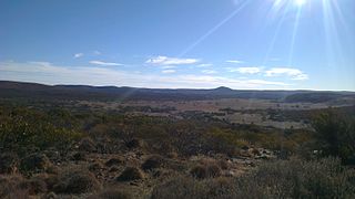
Secret Rocks is a locality in the Australian state of South Australia located on the Eyre Peninsula about 36 kilometres to the east of the town of Kimba and about 227 kilometres north west of the state capital of Adelaide.

Danggali is a locality in the Australian state of South Australia located about 70 kilometres north of the town of Renmark and about 230 kilometres north east of the state capital of Adelaide.

<span class="mw-page-title-main">Chowilla, South Australia</span> Place in South Australia

Chowilla is a locality in the Australian state of South Australia, located on the northern side of the Murray River about 250 kilometres to the north-east of the capital city of Adelaide and about 40 kilometres to the north-east of the town of Renmark, and which is bounded by the border with New South Wales in the east.

Calperum Station is a locality in the Australian state of South Australia located on the northern side of the Murray River about 10 kilometres to the north of the town of Renmark and about 250 kilometres east of the centre of the capital city of Adelaide.

Taylorville Station is a locality in the Australian state of South Australia located about 250 kilometres north-east of the Adelaide and about 35 kilometres to the north-west of the municipal seat of Renmark.

<span class="mw-page-title-main">Calperum Station (reserve)</span> Protected area in South Australia

Calperum Station, also known as Calperum Reserve, is a nature reserve located in the east of the Australian state of South Australia about 10 kilometres north-west of the town of Renmark and about 250 kilometres east of the state capital of Adelaide. Calperum Station consists of three separate pastoral leases - Calperum, Calperum Road and Yubalia.

<span class="mw-page-title-main">Gawler Ranges, South Australia</span> Suburb of Pastoral Unincorporated Area, Wudinna District Council, South Australia

Gawler Ranges is a locality in the Australian state of South Australia located on Eyre Peninsula about 380 kilometres north-west of the Adelaide city centre and about 48 kilometres north of the town centre of Wudinna and which is associated with the protected area known as the Gawler Ranges National Park.

Gerard is a locality in the Australian state of South Australia located in the Riverland on the northern side of the Murray River about 182 kilometres north-east of the state capital of Adelaide and about 12 kilometres (7.5 mi) northwest of Loxton.

<span class="mw-page-title-main">Lake Gilles, South Australia</span> Suburb of Pastoral Unincorporated Area, South Australia

Lake Gilles is a locality in the Australian state of South Australia located on the Eyre Peninsula about 278 kilometres north west of the state capital of Adelaide and about 35 kilometres to the north-east of the town of Kimba.

Baroota is a locality in the Australian state of South Australia located on the east coast of Spencer Gulf about 230 kilometres north of the state capital of Adelaide and about 29 kilometres (18 mi) north-east of the city of Port Pirie.

<span class="mw-page-title-main">Lake Eyre, South Australia</span> Suburb of Pastoral Unincorporated Area, South Australia

Lake Eyre is a locality in the Australian state of South Australia located about 718 kilometres north of the state capital of Adelaide and 134 kilometres north of the town of Marree and which is associated with the occasional body of water known as Lake Eyre.

Gidgealpa is a locality in the Australian state of South Australia located about 780 kilometres north-east of the capital city of Adelaide and about 58 kilometres south-west of the town of Innamincka.

<span class="mw-page-title-main">Simpson Desert, South Australia</span> Suburb of Pastoral Unincorporated Area, South Australia

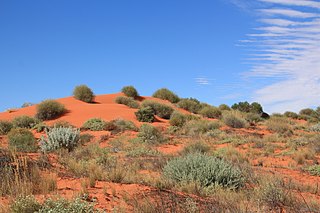
Simpson Desert is a locality in the Australian state of South Australia located about 920 kilometres north of the capital city of Adelaide and which is located within the desert of the same name.

Etadunna is a locality in the Australian state of South Australia located about 684 kilometres north of the capital city of Adelaide and about 108 kilometres north-east of the town of Marree.

Pureba is a locality in the Australian state of South Australia located on the west coast of Eyre Peninsula and on land to the immediate north of the peninsula about 528 kilometres north-west of the state capital of Adelaide and about 52 kilometres north-east and 90 kilometres north respectively of the municipal seats of Ceduna and Streaky Bay.

Mount Willoughby is a locality in the Australian state of South Australia located about 837 kilometres north-west of the capital city of Adelaide and about 84 kilometres north-west of the town of Coober Pedy.

Pooginook is a locality in the Australian state of South Australia located in the state’s east about 167 kilometres (104 mi) north-east of the state capital of Adelaide and about 60 kilometres (37 mi) north-west of the municipal seat in Loxton.

References

  1. 1 2 3 4 "Search results for "Gluepot, LOCB" with the following datasets selected - 'Suburbs and Localities', 'Counties', 'Local Government Areas', 'SA Government Regions', 'Gazetter' and 'Roads'". Location SA Map Viewer. Government of South Australia. Retrieved 2 December 2018.
  2. 1 2 Australian Bureau of Statistics (27 June 2017). "Warnes (State Suburb)". 2016 Census QuickStats. Retrieved 2 December 2018. OOjs UI icon edit-ltr-progressive.svg
  3. 1 2 3 4 "Search result for " Gluepot (LOCB)" (Record no SA0067066)". Property Location Browser. Department of Planning Transport and Infrastructure. Archived from the original on 12 October 2016. Retrieved 26 September 2015.
  4. "Search result for Gluepot, SA". Australia Post. Retrieved 26 September 2015.
  5. 1 2 "Gluepot, automatic weather station". Commonwealth of Australia, Bureau of Meteorology. Retrieved 21 October 2019.
  6. 1 2 "Development Plan, Land Not Within a Council Area Eyre, Far North, Riverland and Whyalla – 18 October 2012" (PDF). Department of Planning, Transport and Infrastructure. 2012. pp. 20, 23 & 289. Archived from the original (PDF) on 23 September 2015. Retrieved 26 September 2015.
  7. 1 2 "Murray and Mallee SA Government region" (PDF). The Government of South Australia. Retrieved 10 October 2014.
  8. 1 2 "District of Stuart Background Profile". Electoral Commission SA. Retrieved 26 September 2015.
  9. 1 2 "Federal electoral division of Grey, boundary gazetted 16 December 2011" (PDF). Australian Electoral Commission. Retrieved 20 August 2015.
  10. 1 2 3 4 "Summary (climate) statistics GLUEPOT RESERVE (GLUEPOT)". Commonwealth of Australia , Bureau of Meteorology . Retrieved 1 December 2018.
  11. 1 2 "( Gluepot Reserve) Introduction". BirdLife Australia Gluepot Reserve. Archived from the original on 29 April 2013. Retrieved 26 September 2015.