
The Kofun period is an era in the history of Japan from about 300 to 538 AD,following the Yayoi period. The Kofun and the subsequent Asuka periods are sometimes collectively called the Yamato period. This period is the earliest era of recorded history in Japan,but studies depend heavily on archaeology since the chronology of historical sources tends to be distorted. The word kofun is Japanese for the type of burial mound dating from this era.

Goguryeo,also called Goryeo,was a Korean kingdom located in the northern and central parts of the Korean Peninsula and the southern and central parts of Northeast China. At its peak of power,Goguryeo controlled most of the Korean peninsula,large parts of Manchuria and parts of eastern Mongolia and Inner Mongolia.
Samhan or the Three Kingdoms of Korea refers to the three kingdoms of Goguryeo,Baekje,and Silla. Goguryeo was later known as Goryeo,from which the modern name Korea is derived. The Three Kingdoms period is defined as being from 57 BC to 668 AD.
The traditional culture of Korea is the shared cultural and historical heritage of Korea and southern Manchuria before the division of Korea in 1945. Manchuria refers to the ancient geographical and historical region in Northeast Asia,including countries like China and Russia. As one of the oldest continuous cultures in the world,Koreans have passed down their traditional narratives in a variety of ways.

Anak Tomb No. 3 is a chamber tomb of Goguryeo located in Anak,South Hwanghae,North Korea. It is known for mural paintings and an epitaph. It is part of the Complex of Koguryo Tombs.
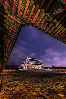
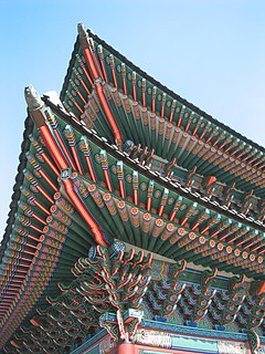
Korean architecture refers to an architectural style that developed over centuries in Korea. Throughout the history of Korea,various kingdoms and royal dynasties have developed a unique style of architecture with influences from Buddhism and Korean Confucianism.
Kofun are megalithic tombs or tumuli in Northeast Asia. Kofun were mainly constructed in the Japanese archipelago between the middle of the 3rd century to the early 7th century CE.

The Takamatsuzuka Tomb or "Tall Pine Tree Ancient Burial Mound" in Japanese is an ancient circular tomb in Asuka village,Nara Prefecture,Japan.

Gungnae (Korean) or Guonei (Mandarin) City was the capital of the ancient Korean kingdom of Goguryeo,which was located in Manchuria and the Korean Peninsula. The perimeter of its outer fortress measures 2,686m. It is located in present day Ji'an city,Jilin province,northeast China. Because of its historical importance and exceptional architecture,Gungnae was designated as a UNESCO World Heritage Site in 2004. It is part of the Capital Cities and Tombs of the Ancient Koguryo Kingdom World Heritage Site,together with nearby Hwando Mountain City and the Onyeosan City,in modern northeast China.
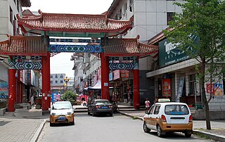
Ji'an is a county-level city in the southwestern part of Jilin province,People's Republic of China. It is administered by the prefecture-level city of Tonghua and is the southernmost county-level division in the province. Ji'an has an area of 3,408 km2 (1,316 sq mi) and a population of approximately 230,000. The city was given its current status in 1988. Ji'an is separated from Manpo,Chagang Province,North Korea by the Yalu River;it has an international border running 203.5 km (126.4 mi).

The Capital Cities and Tombs of the Ancient Koguryo Kingdom is an UNESCO World Heritage Site which includes a number of archaeological sites currently in Ji'an,Jilin Province and Huanren,Liaoning Province in Northeast China. Goguryeo,was a Korean Kingdom located in the northern and central parts of the Korean Peninsula and the southern and central parts of Manchuria.

WunüShan,which means "mountain of Five Women",is a mountain of historical and cultural significance located in the north of the Huanren Town,in Huanren Manchu Autonomous County,Liaoning province,China. It is located northwest of the Hun Jiang River. The tallest peak is the 821 metre-high Main Peak,measuring 1,500 metres long and 300 metres wide.

Hwando is a mountain fortress of the ancient Korean kingdom of Goguryeo,built to protect Goguryeo's second capital,Gungnae. It is located in present-day Ji'an city of the province of Jilin,China.

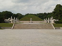
The Tomb of King Dongmyeong,also known as the Tomb of King Tongmyŏng,is a mausoleum located in near Ryongsan Village,Ryokpo-guyok,Pyongyang,North Korea. One of the tombs is the royal tomb of Dongmyeong,the founder of the ancient Goguryeo Kingdom,northernmost of the Three Kingdoms of Korea. In total,there are 63 individual tombs of the period. The area around Dongmyeong contains at least fifteen known tombs believed to belong to various vassal lords. The tomb has achieved World Heritage status as part of the Complex of Goguryeo Tombs inscribed by UNESCO in 2004 under Criteria (i),(ii),(iii) and (iv) covering an area of 233 hectares with a buffer zone of 1,701 hectares. A unique feature of it and the other extant tombs in the area are the wall paintings depicting blossoming lotuses blossoming,an indicative of Buddhism practiced in Korea,in that period.
The Mozu Tombs are a group of megalithic tombs in Sakai,Osaka Prefecture,Japan. Originally consisting of more than 100 tombs,only less than 50% of the key-hole,round and rectangular tombs remain.

Korean fortresses are fortifications constructed by Koreans since the Three Kingdoms of Korea period. Koreans developed a unique and distinct fortress tradition. Korea,beginning with Goguryeo,has been called "a country of fortresses";almost 2,400 mountain fortress sites have been found in Korea.

Yamanoue Stele is an Asuka period stele discovered in the Yamana neighborhood of the city of Takasaki,Gunma Prefecture,in the northern Kantōregion of Japan. The stele was designated a National Historic Site of Japan in 1921,and was raised in status to that of a Special National Historic Site in 1954. It is associated with the adjacent Yamanoue Kofun (山ノ上古墳),a kofun burial mound,which is also covered under the Special Historical Site designation. As one of the "Three Stelae of Kōzuke",the Yamanoue Stele was submitted by Japan for inclusion into the UNESCO Memory of the World Programme in 2017 The inscription on the Yamanoue Stele is the oldest example of writing in Chinese characters according to Japanese grammar.

The Saikitama Kofun Cluster is a group of burial mounds located in the city of Gyōda,Saitama Prefecture,in the Kantōregion of Japan. The site was designated a National Historic Site in 1938,and was upgraded in status to a Special National Historic Site of Japan in 2020. The site consists of nine large kofun,which were built in the 5th to 7th centuries AD,i.e. from the late Kofun period into the Asuka period,when the construction of burial mounds was already out of fashion in western Japan.

The Yamato Kingship was a tribal alliance centered on the Yamato region from the 4th century to the 7th century,and ruled over the alliance of noble families in the central and western parts of the Japanese archipelago. The age is from the 4th to the 7th century,later than the Yamatai Kingdom. After the Taika Reform,the ōkimi as an emperor,at that time,was in power,and the Yamato period ended. Archaeologically known as the Kofun period. Regarding its establishment,due to the relationship between Yamatai and Yamato's succession to the king's power,there are very different views on it.

The Ōtani Kofun (大谷古墳) is a kofun burial mound located in the city of Wakayama,Wakayama Prefecture,in the Kansai region of Japan. The tumulus was designated a National Historic Site in 1978. The artifacts excavated from the tumulus were designated as National Important Cultural Properties in 1982.

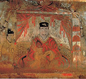 The mural of Goguryeo and former Yan official,Dong Shou (Hanja:佟寿) in Anak Tomb No. 3