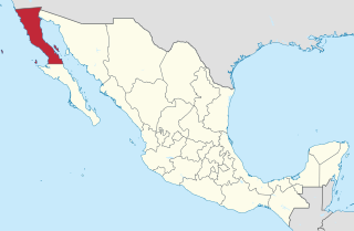
Baja California, officially the Free and Sovereign State of Baja California, is a state in Mexico. It is the northernmost and westernmost of the 32 Federal Entities of Mexico. Before becoming a state in 1952, the area was known as the North Territory of Baja California. It has an area of 70,113 km2 (27,071 sq mi), or 3.57% of the land mass of Mexico and comprises the northern half of the Baja California Peninsula, north of the 28th parallel, plus oceanic Guadalupe Island. The mainland portion of the state is bordered on the west by the Pacific Ocean, on the east by Sonora, the U.S. state of Arizona, and the Gulf of California, and on the south by Baja California Sur. Its northern limit is the U.S. state of California.

Ensenada is a coastal city in Mexico, the third-largest in Baja California. Lying 125 kilometres (78 mi) south of San Diego on the Baja California Peninsula, it is locally referred to as La Cenicienta del Pacífico, "The Cinderella of the Pacific".

Rosarito is a coastal resort city in the Mexican state of Baja California located approximately 10 miles south of the U.S. border in Rosarito Beach Municipality. Often mistakenly called Rosarito Beach because of the well-known Rosarito Beach Hotel, the town of Rosarito is one part of the municipality named Playas de Rosarito.
Baja California is a state in Northwest Mexico that is divided into five municipalities.. According to the 2015 Mexican Intercensal Survey, Baja California is the 13th most populous state with 3,315,766 inhabitants and the 12th largest by land area spanning 73,290.08 square kilometres (28,297.46 sq mi).

San Quintín is a coastal town on the west coast of the Mexican state of Baja California, in the Municipality of Ensenada, some 190 km (118 mi.) south of the city of Ensenada on Mexican Federal Highway 1. The town is also in the middle of an important agricultural area, especially for growing strawberries and tomatoes. The largest nearby locality is Lázaro Cardenas, home to 16,294 people as of the 2010 census. The whole area houses roughly 25,000 people, up from 20,000 in 2000. This is the largest population cluster south of Ensenada within the state.

The Valle de Guadalupe is an area of Ensenada Municipality, Baja California, Mexico that is an increasingly popular tourist destination for wine and Baja Med cuisine. It is located 20 kilometres (12 mi) north of the City of Ensenada and 113 kilometres (70 mi) southeast of the border crossing from San Diego to Tijuana. It includes communities such as Ejido El Porvenir, Francisco Zarco and San Antonio De las Minas, and had 2,664 inhabitants.

The Mexican Riviera refers collectively to twenty cities and lagoons lying on the western coast of Mexico. Although there are long distances between these cities, they are often collectively referred to as the Mexican Riviera because of their many oceanfront resorts and their popularity among tourists. Cruise ships often visit three or four of these destinations on their longer cruises. In a 2005 interview Stanley McDonald, the founder of Princess Cruises, mentioned:
The call of the "Mexican Riviera" was coined by Princess Cruise Line. Now everyone refers to it as the Mexican Riviera. I believe that it really spoke to the quality and beauty of what people would see down there. We all know the French Riviera -- the Mexican Riviera was something we had in the western hemisphere.

The municipality of Ensenada, with a land area of 52,482.40 km2 (20,263.57 sq mi), is the largest municipality in Mexico by area. The municipality takes up 72.6% of the land area of Baja California but is home to only 14.7% of the population. It shares borders with Baja California's four other municipalities to the north and northeast as well as with Mulegé Municipality in Baja California Sur to the south. Its municipal seat is Ensenada, which lies near the northwest corner of the municipality.

Federal Highway 1 is a free (libre) part of the federal highway corridors of Mexico, and the highway follows the length of the Baja California Peninsula from Tijuana, Baja California, in the north to Cabo San Lucas, Baja California Sur, in the south. The road connects with Via Rapida, which merges into the American Interstate 5 (I-5) at the international border south of San Ysidro, California.

Tijuana Municipality is a municipality in the Mexican state of Baja California. Its municipal seat is located in the city of Tijuana. According to the 2010 census, the municipality had a population of 1,559,683 inhabitants, of whom 1,300,983, or 83.4%, lived in the city of Tijuana. The municipality maintained its position as 3rd most populated nationally as of 2015 census, only behind Ecatepec de Morelos and Iztapalapa. Juan Manuel Gastélum of the PAN is the current municipal president. The municipality comprises the largest part of the Tijuana metropolitan area.

Coastal sage scrub, also known as coastal scrub, CSS, or soft chaparral, is a low scrubland plant community of the California coastal sage and chaparral subecoregion, found in coastal California and northwestern coastal Baja California. It is within the California chaparral and woodlands ecoregion, of the Mediterranean forests, woodlands, and scrub biome.
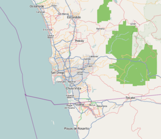
San Diego–Tijuana is an international metropolitan conurbation, straddling the border of the adjacent North American coastal cities of San Diego, California, United States and Tijuana, Baja California, Mexico. The 2012 population of the region was 4,922,723, making it the largest bi-national conurbation shared between the United States and Mexico, the second-largest shared between the US and another country, and the fourth largest in the world. In its entirety, the region consists of San Diego County in the United States and the municipalities of Tijuana, Rosarito Beach, and Tecate in Mexico. It is the third most populous region in the California–Baja California region, smaller only than the metropolitan areas of Greater Los Angeles and the San Francisco Bay Area.

The Tijuana metropolitan area, and in Spanish the Zona Metropolitana de Tijuana, is located by the Pacific Ocean in Mexico. The 2010 census placed the Tijuana metropolitan area as the fifth largest city by population in the country with 1,751,302 persons. The census bureau defined metropolitan area comprises two municipalities: Tijuana and Rosarito Beach. Yet sources commonly include Tecate Municipality in the metropolitan area as the urban area between Tijuana and Tecate grows, the commuting populace increases - ultimately further developing the southern areas of San Diego–Tijuana, and the three municipalities maintain strong relationships and cooperation.
Transportation in San Diego–Tijuana occurs by various means. Though, in the four cities of San Diego, Tijuana, Tecate, and Rosarito Beach, the automobile serves as most important means of transportation. The international metropolitan region maintains an intricate highway infrastructure. As a large metropolitan area in Western North America, many roadways, including Interstates, State Routes, and Mexican Federal Highways, hold a terminus in the area. These roads have grown accustomed to support the masses of the commuting populace within the international region and are constantly being expanded and/or renovated. Transportation is a crucial issue in the metropolitan area. The streets and highways of the region affect environmental health and have influence over the degree of regional connectivity. Binational discussions about coordinating public transportation across the border are currently underway. San Diego–Tijuana is the site of two major international airports and numerous regional airports. It is also the site of the Port of San Diego and miles from the nearby Port of Ensenada.
Baja Malibu is a beach and resort in Tijuana Municipality, Baja California named after the beach town Malibu of Los Angeles County. The beach is a popular tourist area in the San Diego–Tijuana metropolitan region and draws surfers from all over Southern California.

The Autonomous University of Baja California is a public institution of higher education in the Mexican state of Baja California. UABC is one of the 43 state universities throughout Mexico as part of the country's state university system. Its headquarters are located in the city of Mexicali.
Baja Mar is a seaside resort community twenty minutes north of Ensenada and forty minutes south of Greater San Diego–Tijuana in Ensenada Municipality, Baja California, Mexico. The resort community is located just south of another gringo community, La Salina – host of the Puerto Salina marina.

The Port of Ensenada is a marine freight and cruise terminal in Ensenada, Baja California. This deepwater port lies in Bahia de Todos Santos and in 2010 brought in 3,592,891 metric tons of cargo. Ships arrive to the port from major ports in Asia, North America, and South America. The ports accommodates cargo and cruise terminals as well as serving as an unloading dock for containers. Activities based from within the port extend to commercial and sport fishing, pleasure craft, and marina areas. The Port of Ensenada maintains specialized shipyards and handles tons of mineral bulk. The Port of Ensenada is also Mexico's second busiest port as well as the second most visited port-of-call for major cruise lines and pleasure boats in Mexico.
Baja Med is a fusion cuisine of Mexican cuisine, such as chicharrón and cotija cheese, with those of Mediterranean, such as olive oil, and Asian cuisine, such as lemongrass. Baja Med dishes showcase the fresh produce and seafood of Baja California.
