
Krosno County is a unit of territorial administration and local government (powiat) in Lubusz Voivodeship, western Poland, on the German border. It came into being on January 1, 1999, as a result of the Polish local government reforms passed in 1998. Its administrative seat is the town of Krosno Odrzańskie, which lies 30 km (19 mi) west of Zielona Góra and 79 km (49 mi) south of Gorzów Wielkopolski. The only other town in the county is Gubin, situated on the German border 28 km (17 mi) west of Krosno Odrzańskie.

Czarnków-Trzcianka County is a unit of territorial administration and local government (powiat) in Greater Poland Voivodeship, west-central Poland. It came into being on January 1, 1999, as a result of the Polish local government reforms passed in 1998. Its administrative seat is the town of Czarnków, which lies 61 kilometres (38 mi) north-west of the regional capital Poznań. The county contains three other towns: Trzcianka, 18 km (11 mi) north of Czarnków, Krzyż Wielkopolski, 38 km (24 mi) west of Czarnków, and Wieleń, 27 km (17 mi) west of Czarnków.
Ostrów County is a unit of territorial administration and local government (powiat) in Greater Poland Voivodeship, west-central Poland. It came into being on January 1, 1999, as a result of the Polish local government reforms passed in 1998. Its administrative seat and largest town is Ostrów Wielkopolski, which lies 100 kilometres (62 mi) south-east of the regional capital Poznań. The county contains three other towns: Nowe Skalmierzyce, 22 km (14 mi) east of Ostrów Wielkopolski, Odolanów, 10 km (6 mi) south of Ostrów Wielkopolski, and Raszków, 8 km (5 mi) north of Ostrów Wielkopolski.
Krotoszyn County is a unit of territorial administration and local government (powiat) in Greater Poland Voivodeship, west-central Poland. It came into being on January 1, 1999, as a result of the Polish local government reforms passed in 1998. Its administrative seat and largest town is Krotoszyn, which lies 88 kilometres (55 mi) south-east of the regional capital Poznań. The county contains four other towns: Koźmin Wielkopolski, 16 km (10 mi) north of Krotoszyn, Zduny, 6 km (4 mi) south-west of Krotoszyn, Kobylin, 14 km (9 mi) west of Krotoszyn, and Sulmierzyce, 12 km (7 mi) south-east of Krotoszyn.

Jarocin County is a unit of territorial administration and local government (powiat) in Greater Poland Voivodeship, west-central Poland. It came into being on January 1, 1999, as a result of the Polish local government reforms passed in 1998. Its administrative seat and largest town is Jarocin, which lies 63 kilometres (39 mi) south-east of the regional capital Poznań. The only other town in the county is Żerków, lying 12 km (7 mi) north of Jarocin.

Rawicz County is a unit of territorial administration and local government (powiat) in Greater Poland Voivodeship, west-central Poland. It came into being on January 1, 1999, as a result of the Polish local government reforms passed in 1998. Its administrative seat and largest town is Rawicz, which lies 88 kilometres (55 mi) south of the regional capital Poznań. The county contains three other towns: Miejska Górka, 9 km (6 mi) north-east of Rawicz, Bojanowo, 13 km (8 mi) north-west of Rawicz, and Jutrosin, 22 km (14 mi) east of Rawicz.

Grodzisk County is a unit of territorial administration and local government (powiat) in Greater Poland Voivodeship, west-central Poland. It came into being on January 1, 1999, as a result of the Polish local government reforms passed in 1998. Its administrative seat and largest town is Grodzisk Wielkopolski, which lies 42 kilometres (26 mi) south-west of the regional capital Poznań. The county also contains the towns of Rakoniewice, lying 13 km (8 mi) south-west of Grodzisk Wielkopolski, and Wielichowo, 13 km (8 mi) south of Grodzisk Wielkopolski.

Ostrzeszów County is a unit of territorial administration and local government (powiat) in Greater Poland Voivodeship, west-central Poland. It came into being on January 1, 1999, as a result of the Polish local government reforms passed in 1998. Its administrative seat and largest town is Ostrzeszów, which lies 134 kilometres (83 mi) south-east of the regional capital Poznań. The county also contains the towns of Grabów nad Prosną, lying 14 km (9 mi) north-east of Ostrzeszów, and Mikstat, 15 km (9 mi) north of Ostrzeszów.

Kościan County is a unit of territorial administration and local government (powiat) in Greater Poland Voivodeship, west-central Poland. It came into being on January 1, 1999, as a result of the Polish local government reforms passed in 1998. Its administrative seat and largest town is Kościan, which lies 40 kilometres (25 mi) south-west of the regional capital Poznań. The county contains three other towns: Śmigiel, 13 km (8 mi) south-west of Kościan, Czempiń, 13 km (8 mi) north-east of Kościan, and Krzywiń, 18 km (11 mi) south-east of Kościan.

Śrem County is a unit of territorial administration and local government (powiat) in Greater Poland Voivodeship, west-central Poland. It came into being on January 1, 1999, as a result of the Polish local government reforms passed in 1998. Its administrative seat and largest town is Śrem, which lies 36 kilometres (22 mi) south of the regional capital Poznań. The county also contains the towns of Książ Wielkopolski, lying 15 km (9 mi) east of Śrem, and Dolsk, 12 km (7 mi) south of Śrem.

Nowy Tomyśl County is a unit of territorial administration and local government (powiat) in Greater Poland Voivodeship, west-central Poland. It came into being on January 1, 1999, as a result of the Polish local government reforms passed in 1998. Its administrative seat and largest town is Nowy Tomyśl, which lies 55 kilometres (34 mi) west of the regional capital Poznań. The county contains three other towns: Opalenica, 20 km (12 mi) east of Nowy Tomyśl, Zbąszyń, 17 km (11 mi) south-west of Nowy Tomyśl, and Lwówek, 16 km (10 mi) north of Nowy Tomyśl.

Kalisz County is a unit of territorial administration and local government (powiat) in Greater Poland Voivodeship, west-central Poland. It came into being on 1 January 1999 as a result of the Polish local government reforms passed in 1998. Its administrative seat is the city of Kalisz, although the city is not part of the county. The only town in Kalisz County is Stawiszyn, which lies 18 km (11 mi) north of Kalisz.
Żnin County is a unit of territorial administration and local government (powiat) in Kuyavian-Pomeranian Voivodeship, north-central Poland. It came into being on January 1, 1999, as a result of the Polish local government reforms passed in 1998. Its administrative seat and largest town is Żnin, which lies 36 km (22 mi) south-west of Bydgoszcz and 65 km (40 mi) west of Toruń. The county contains three other towns: Barcin, lying 17 km (11 mi) east of Żnin, Łabiszyn, lying 19 km (12 mi) north-east of Żnin, and Janowiec Wielkopolski, 18 km (11 mi) south-west of Żnin.

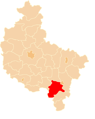
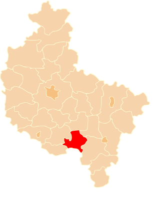
Gmina Gostyń is an urban-rural gmina in Gostyń County, Greater Poland Voivodeship, in west-central Poland. Its seat is the town of Gostyń, which lies approximately 59 kilometres (37 mi) south of the regional capital Poznań.
Gmina Borek Wielkopolski is an urban-rural gmina in Gostyń County, Greater Poland Voivodeship, in west-central Poland. Its seat is the town of Borek Wielkopolski, which lies approximately 17 kilometres (11 mi) east of Gostyń and 59 km (37 mi) south-east of the regional capital Poznań.
Gmina Krobia is an urban-rural gmina in Gostyń County, Greater Poland Voivodeship, in west-central Poland. Its seat is the town of Krobia, which lies approximately 11 kilometres (7 mi) south of Gostyń and 69 km (43 mi) south of the regional capital Poznań.
Gmina Pępowo is a rural gmina in Gostyń County, Greater Poland Voivodeship, in west-central Poland. Its seat is the village of Pępowo, which lies approximately 15 kilometres (9 mi) south-east of Gostyń and 73 km (45 mi) south of the regional capital Poznań.
Gmina Piaski is a rural gmina in Gostyń County, Greater Poland Voivodeship, in west-central Poland. Its seat is the village of Piaski, which lies approximately 5 kilometres (3 mi) east of Gostyń and 59 km (37 mi) south of the regional capital Poznań.
Gmina Pogorzela is an urban-rural gmina in Gostyń County, Greater Poland Voivodeship, in west-central Poland. Its seat is the town of Pogorzela, which lies approximately 17 kilometres (11 mi) south-east of Gostyń and 68 km (42 mi) south of the regional capital Poznań.

Gmina Poniec is an urban-rural gmina in Gostyń County, Greater Poland Voivodeship, in west-central Poland. Its seat is the town of Poniec, which lies approximately 20 kilometres (12 mi) south-west of Gostyń and 72 km (45 mi) south of the regional capital Poznań.


