Earley is a town and civil parish in the Borough of Wokingham, Berkshire, England. Along with the neighbouring town of Woodley, the Office for National Statistics places Earley within the Reading/Wokingham Urban Area; for the purposes of local government it falls within the Borough of Wokingham, outside the area of Reading Borough Council. Its name is sometimes spelt Erleigh or Erlegh and consists of a number of smaller areas, including Maiden Erlegh and Lower Earley, and lies some 3 miles (5 km) south and east of the centre of Reading, and some 4 miles (6 km) northwest of Wokingham. It had a population of 32,036 at the 2011 Census.
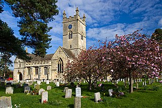
Bishop's Cleeve is a village and civil parish in the Borough of Tewkesbury in the ceremonial county of Gloucestershire, England. The village lies at the foot of Cleeve Hill, the highest point in the Cotswolds. Bishop's Cleeve had a population of 10,612 in 2011, which has increased to 14,068 in the 2021 Census. The village is 13 miles (21 km) from Gloucester and 44 miles (71 km) from Oxford. The village is also close to the towns of Cheltenham, Tewkesbury and Evesham.

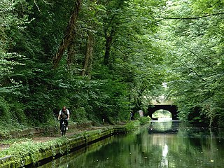
The Gloucestershire Warwickshire Steam Railway is a volunteer-run heritage railway which runs along the Gloucestershire/Worcestershire border of the Cotswolds in England.

Southam is a village in Gloucestershire, England, located on the outskirts of Cheltenham. Its main features are a Manor House, which has now been converted to a hotel, a 12th Century Church and the Gloucestershire Warwickshire Railway, which runs through the outskirts of the village.

Bramhope is a village and civil parish in the City of Leeds metropolitan borough, West Yorkshire, England, north of Holt Park and north east of Cookridge.

Woodmancote is a village and civil parish in Gloucestershire, England. The parish lies immediately east of Bishop's Cleeve; the village is about 3+1⁄2 miles (6 km) north of Cheltenham. In old English the name meant 'woodmen's cottage' and an early form was Wudumannacote. In the southeast of the parish is the small village of Cleeve Hill, under the slopes of the hill of the same name.
Olton is an area/suburban village within the Metropolitan Borough of Solihull in the West Midlands, England. In the 13th century, the Lords of the Manor moved their seat and formed a new settlement, at the junction of two major roads. It was then that Ulverlei was being referred to as ‘Oulton’ to distinguish itself from nearby Solihull. Historically within the county of Warwickshire, the village has gradually become contiguous with Solihull to the southeast, though it retains the character of a large independent village.

Alderton is a village and civil parish in the Tewkesbury district of Gloucestershire, England.

Bishop's Sutton or Bishop's Sutton is a village and civil parish one mile (1.6 km) east of the market town of Alresford in the City of Winchester district of Hampshire, England. According to the 2001 census it had a population of 419, increasing to 463 at the 2011 Census.

Leckhampton is a village and a district in south Cheltenham, Gloucestershire, England. The area is in the civil parish of Leckhampton with Warden Hill and is part of the district of Cheltenham. The population of the civil parish taken at the 2011 census was 4,409.

Ospringe is a village and area of Faversham in the English county of Kent. It is also the name of a civil parish, which since 1935 has not included the village of Ospringe.

Old Cleeve is a village 5 miles (8 km) south east of Minehead in the Somerset West and Taunton district of Somerset, England, and also a civil parish. The civil parish of Old Cleeve covers an area of 2,092 hectares and includes the villages of Old Cleeve, Roadwater and Washford as well as hamlets such as Bilbrook, Chapel Cleeve, Golsoncott and Leighland Chapel. Approximately half the parish lies within the Exmoor National Park. The remaining half is on the southern edge of Exmoor. The village has been in existence since the early 13th century. The village held its first council meeting in 1711. By the 1720s the parish had several churches, in which to meet. The town hall was built in 1727. The first church here was built in 1694, built by the Eastern Christian Society. This church was destroyed in a fire in 1847, and has been rebuilt and restored. In 2011, the population of the parish was 1,672.

Leigh is a civil parish in the English county of Staffordshire. The parish includes the village of Church Leigh, together with the settlements of Withington, Upper Leigh, Lower Leigh, Morrilow Heath, Middleton Green, Dodsley, Godstone, Nobut and Field.

Sedgeberrow is a village and civil parish in the Wychavon district of Worcestershire, England, about 3 miles (4.8 km) south of Evesham. It stands beside the River Isbourne, a tributary of the River Avon.
Up Hatherley is a civil parish and a suburb of the spa town of Cheltenham, Gloucestershire, England. Formerly a hamlet in the parish of Shurdington, it became a parish in 1887 and became a part of Cheltenham in 1991.

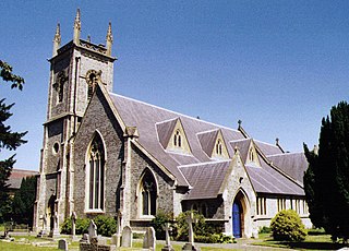
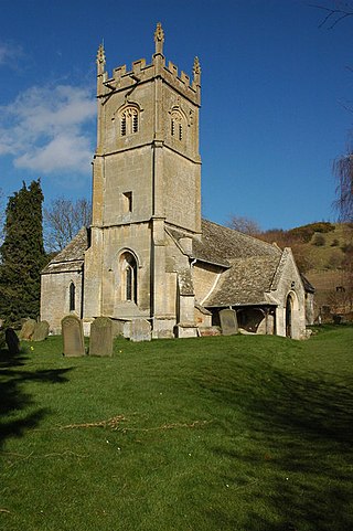
St Michael & All Angels is the Anglican church in the village of Bishop's Cleeve, just north of Cheltenham in Gloucestershire. Informally the church is known simply as St Michael's.
Oxenton is a village and civil parish 11 miles (18 km) north east of Gloucester, in the Tewkesbury district, in the county of Gloucestershire, England. In 2011 the parish had a population of 162. The parish touches Alderton, Ashchurch Rural, Gotherington, Teddington and Stoke Orchard. It is on the west side of Oxenton Hill, a northern outlier of the Cotswolds. Oxenton has a parish meeting.
Sutton Walmley and Minworth is one of 69 electoral wards in Birmingham, England.

Woolstone is a village and former civil parish now in the parish of Oxenton, in the Tewkesbury district, in the county of Gloucestershire, England. It is about 5 miles (8 km) miles from the town of Cheltenham. The village is on the southern side of Crane Hill and on the north bank of the Tirle Brook. In 1931 the parish had a population of 85. Woolstone has a church called St Martin's Church which is grade II* listed.