Listed buildings
| Name | Photograph | Date | Location [A] | Description [B] | Link to English Heritage database [C] | Link to Images of England database [D] | Link to British Listed Buildings database [E] |
|---|---|---|---|---|---|---|---|
| St. Alban's Church |  | 1933 | SU4314015688 50°56′20″N1°23′15″W / 50.9390°N 1.3874°W | Designed by Welch, Cachemaille-Day and Lander, this Anglican church has a Latin Cross plan and is late Gothic in style. The traditional outward appearance of the Church hides an internal layout that was innovative at the time of construction. The east end of the Church which would normally have formed the Chancel was used as a Lady Chapel, while the Main Altar was sited under the central tower much closer to the congregation. | |||
| Former St. Augustine's Church |  | 1881 | SU4304112547 50°54′39″N1°23′21″W / 50.9108°N 1.3892°W | ||||
| St. Christopher's Mission Hall |  | late 18th to early 19th century | SU4291616318 50°56′41″N1°23′26″W / 50.9447°N 1.3905°W | ||||
| St. Denys Church |  | 1868 | SU4345114096 50°55′29″N1°22′59″W / 50.9247°N 1.3831°W | ||||
| St. Denys Priory |  | 1338 | SU4360314145 50°55′30″N1°22′52″W / 50.9251°N 1.3810°W | ||||
| St. Denys railway station |  | 1867 | SU4308713784 50°55′19″N1°23′18″W / 50.9219°N 1.3884°W | ||||
| St. Edmund's Church |  | 1889 | SU4205613006 50°54′54″N1°24′11″W / 50.9150°N 1.4031°W | ||||
| St. James' Church, Shirley | 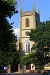 | 1836 | SU4028014299 50°55′36″N1°25′42″W / 50.9267°N 1.4282°W | ||||
| St. Joseph's Church |  | 1843–1850 | SU4188611250 50°53′57″N1°24′21″W / 50.8992°N 1.4057°W | ||||
| St. Julien’s Hospital – garden wall | 12th and 15th centuries | SU4207410966 50°53′48″N1°24′11″W / 50.8967°N 1.4031°W | |||||
| St. Mark's Church, Woolston |  | 1863 | SU4381310572 50°53′35″N1°22′42″W / 50.8930°N 1.3784°W | ||||
| St. Mary Extra Cemetery Chapels | 1879 | SU4569010850 50°53′43″N1°21′06″W / 50.8953°N 1.3517°W | |||||
| St. Mary’s churchyard boundary wall | early 18th century | SU4396915453 50°56′13″N1°22′32″W / 50.9369°N 1.3756°W | |||||
| St. Mary's Church, Sholing | 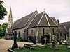 | 1866 | SU4527411283 50°53′57″N1°21′27″W / 50.8993°N 1.3576°W | ||||
| St. Mary's College | early 19th century | SU4452213551 50°55′11″N1°22′05″W / 50.9197°N 1.3680°W | |||||
| 76 St. Mary Street | 1884 | SU4249711963 50°54′20″N1°23′49″W / 50.9056°N 1.3969°W | Not listed | ||||
| 153 St. Mary Street |  | 18th century | SU4255211752 50°54′13″N1°23′46″W / 50.9037°N 1.3962°W | ||||
| St. Mary's Church | 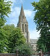 | 1878 | SU4262211657 50°54′10″N1°23′43″W / 50.9028°N 1.3952°W | ||||
| St. Michael and All Angels Church |  | 1897 | SU4187416301 50°56′41″N1°24′19″W / 50.9446°N 1.4053°W | ||||
| St. Michaels Parish Hall | early 19th century | SU4189811316 50°53′59″N1°24′20″W / 50.8998°N 1.4056°W | |||||
| Vaults and remains adjoining Nos. 4 and 5 St. Michaels Square | 12th century | SU4192011271 50°53′58″N1°24′19″W / 50.8994°N 1.4053°W | |||||
| 4 St. Michaels Square | 14th and 19th centuries | SU4191311272 50°53′58″N1°24′19″W / 50.8994°N 1.4054°W | |||||
| 5 St. Michaels Square | 16th century | SU4190511273 50°53′58″N1°24′20″W / 50.8994°N 1.4055°W | |||||
| No. 8 & vault underneath, St. Michaels Square | early 15th and 19th centuries | SU4188811316 50°53′59″N1°24′21″W / 50.8998°N 1.4057°W | |||||
| Gas lamp in St. Michaels Square |  | ca. 1821 | SU4188511293 50°53′59″N1°24′21″W / 50.8996°N 1.4057°W | Not listed | |||
| Vault below No. 11 St. Michaels Square | late 14th century | SU4190411316 50°53′59″N1°24′20″W / 50.8998°N 1.4055°W | |||||
| Vaults below Nos. 15 & 16 St. Michaels Square | mediaeval | SU4192511315 50°53′59″N1°24′19″W / 50.8998°N 1.4052°W | |||||
| 5 St. Michaels Street |  | mid 19th century | SU4198011275 50°53′58″N1°24′16″W / 50.8994°N 1.4044°W | ||||
| 6 & 8 St. Michaels Street | ca. 1870s | SU4199911274 50°53′58″N1°24′14″W / 50.8994°N 1.4040°W | Not listed | ||||
| Former St. Peter's Church |  | 1845 | SU4152512346 50°54′33″N1°24′39″W / 50.9091°N 1.4107°W | ||||
| Seaway House |  | ca. 1860 | SU4195710981 50°53′48″N1°24′17″W / 50.8968°N 1.4048°W | ||||
| Ship Inn | 16th or 17th century | SU3716913644 50°55′16″N1°28′21″W / 50.9211°N 1.4726°W | |||||
| Shirley Precinct drinking fountain |  | 1887 | SU3982213933 50°55′25″N1°26′05″W / 50.9235°N 1.4348°W | ||||
| 350 Shirley Road | ca. 1840 | SU4028213320 50°55′04″N1°25′42″W / 50.9179°N 1.4283°W | |||||
| Singh Sabha Gurdwara (formerly St. Luke's Church) | 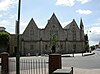 | 1852 | SU4240012886 50°54′50″N1°23′54″W / 50.9139°N 1.3982°W | Built in a neo-Gothic style by architect John Elliott of Chichester. It was enlarged in 1860 and a chancel was added in 1873 by James Piers St Aubyn. In 1983 the church was sold and converted into a Sikh temple. [5] | |||
| South Western House | 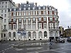 | 1872 | SU4250911032 50°53′50″N1°23′49″W / 50.8972°N 1.3969°W | ||||
| Stella memorial |  | ca. 1900 | SU4178511129 50°53′53″N1°24′26″W / 50.8981°N 1.4072°W | Situated on Town Quay, this is a memorial to Mary Ann Rogers, a stewardess on the SS Stella , sailing from Southampton to Guernsey when it sank on the night of 30 March 1899. She gave up her lifejacket and her place in a lifeboat so that passengers could be saved. [6] It is a stone hexagonal structure supported on six columns with round-headed arches. It has a cornice decorated with Tudor roses and a stepped roof surmounted by a ball finial. The drinking fountain is in a central thicker column having an integral bowl with guilloche moulding. | |||
| The Sun Buildings |  | mid 19th century | SU4193211941 50°54′19″N1°24′18″W / 50.9054°N 1.4050°W | ||||
| Supermarine Slipway | 1936–1937 | SU4347611281 50°53′58″N1°22′59″W / 50.8994°N 1.3831°W | Not listed | Not listed | |||
| Swaythling railway station |  | 1883 | SU4392315929 50°56′28″N1°22′34″W / 50.9411°N 1.3762°W | One storey red brick station building with orange brick dressings, built in an elaborate Neo-Flemish style. The left side has a Flemish gable with a central pediment and ball finials and includes a date tablet. | |||
| Swiss Cottage | late19th century | SU4264213947 50°55′24″N1°23′41″W / 50.9234°N 1.3947°W | |||||
Notes
- A Location is given first as a grid reference, based on the British national grid reference system (or OSGB36) of the Ordnance Survey; [7] and second as World Geodetic System 84 coordinates, used by the Global Positioning System.
- B Unless otherwise stated, the descriptions are based on those on the English Heritage database.
- C The English Heritage database is the official listing and includes a description of the property, the reasons for designation, the date of listing and an extract from the Ordnance Survey map at a scale of 1:2500 pinpointing the exact location of the building.
- D The Images of England database includes the details of the property from the English Heritage database with a photograph of the listed building.
- E The British Listed Buildings database also includes the details of the property from the English Heritage database, together with links to Google/street view, Ordnance Survey and Bing maps/birds eye view.