Grandin station

Last updated

Grandin
Edmonton LRT station
Grandin LRT Station 2019.jpg
Coordinates 53°32′10″N113°30′37″W / 53.53611°N 113.51028°W / 53.53611; -113.51028 Coordinates: 53°32′10″N113°30′37″W / 53.53611°N 113.51028°W / 53.53611; -113.51028
Owned by City of Edmonton
Platforms centre platform
Tracks2
Construction
Structure typeunderground
Disabled accessYes
Other information
Website Grandin/Government Centre LRT Station
History
Opened1989
Electrified600 V DC [1]
Passengers
2019
(typical weekday)
3,105 board
2,914 alight
6,019 Total [2]
Services
Preceding station Edmonton LRT Following station
Corona
toward Clareview
Capital Line University
toward Century Park
Corona
toward NAIT
Metro Line

Grandin station (also known as Grandin/Government Centre station) is an Edmonton Light Rail Transit station in Edmonton, Alberta, Canada. It serves both the Capital Line and the Metro Line. It is an underground station located beneath 110 Street between 99 Avenue and 98 Avenue. The station provides service to the Government Centre part of the downtown core and the neighbourhood of Oliver. The station is connected to the Alberta Legislature Building and several other government buildings by underground walkways of the Edmonton Pedway.

Contents

History

Grandin station was opened in September 1989 when the LRT system was extended 0.8 km south from the Corona station through a light rail tunnel running beneath the downtown core. [3]

Grandin station was the southern terminus of the LRT line prior to the opening of University station in August 1992. Grandin station is connected to the University station by the Dudley B. Menzies Bridge, [4] a dedicated LRT bridge (with a lower level for pedestrians and cyclists).

Renaming

In June 2021, Edmonton city council voted unanimously to remove the name 'Grandin' from the station, due to Bishop Vital-Justin Grandin's active involvement in Canada's Indian residential schools system and the cultural genocide of Indigenous peoples. [5]

Station layout

The platform is a 123-metre-long centre-loading platform that can accommodate two five-car LRT trains at the same time, with one train on each side of the platform. The platform is just over eight metres wide. Access to the platform is from the surface by stairs and escalators located at each end of the platform. The escalator and stairs at the south end of the platform connect to a pedway system that provides access to several government buildings near the station. This pedway is separate from, and not part of, the Edmonton pedway system. [6]

Public art

The station's west wall features a mural of Bishop Vital-Justin Grandin, the first Catholic bishop in Alberta. It was designed by artist Sylvie Nadeau, and it was donated by the Francophone jeunesse de l'Alberta. [7] After criticism from local First Nations activists that the Nadeau mural could be interpreted as celebratory of the Indian residential schools system, local artist Aaron Paquette was commissioned to create a second "response" mural from a First Nations cultural perspective. [8] Following a decision by Edmonton city council in 2021, the mural of Grandin will be covered. [9]

Around the station

110 Street entrances to Grandin Station, serving the neighbourhood of Oliver. GrandinStation110StreetEntrancesJuly2020.jpg
110 Street entrances to Grandin Station, serving the neighbourhood of Oliver.

Government Centre Transit Centre

Government Centre
Transit Centre
Government Centre Transit Centre 2019.jpg
Coordinates 53°32′10″N113°30′16″W / 53.53611°N 113.50444°W / 53.53611; -113.50444
Platforms10 bus bays [10]
Construction
ParkingNo
Disabled accessYes
Other information
Website Government Centre Transit Centre

The Government Centre Transit Centre is located on 107 Street south of 99 Avenue, adjacent to the Legislature grounds. The transit centre is served by ETS, St. Albert Transit (StAT) and Strathcona County Transit (SCT). There are few amenities at the transit centre itself, other than a large shelter. [11]

The following bus routes serve the transit centre: [12] [13] [14]

To/FromRoutes
Castle Downs Transit Centre 150XETS
Downtown 120X, 130X, 150X, 208, 403, 413, 701ETS, StAT, SCT
Eaux Claires Transit Centre 120X, 130XETS
Kingsway Transit Centre 701ETS
MacEwan 208, 403, 413StAT, SCT
NAIT 413SCT
Northgate Transit Centre 120XETS
Sherwood Park Bethel Transit Terminal 413SCT
Sherwood Park Ordze Transit Centre 403SCT
Southgate Transit Centre 701ETS
St. Albert Centre Exchange 208StAT
St. Albert Village Transit Station 208StAT
Strathcona / Whyte Ave701ETS

The above list does not include LRT services from the adjacent LRT station.

Related Research Articles

Edmonton Transit Service public transit service in Edmonton, Alberta, Canada

The Edmonton Transit Service (ETS) is the public transit service owned and operated by the City of Edmonton in Alberta, Canada. It operates Edmonton's bus and light rail systems.

Stadium station (Edmonton) Light rail station in Edmonton, Alberta, Canada

Stadium station is an Edmonton Light Rail Transit station in Edmonton, Alberta, Canada. It serves the Capital Line. It is a ground-level station located at 111 Avenue and 84 Street, next to Commonwealth Stadium and Clarke Stadium.

Edmonton Light Rail Transit light rail system in Edmonton, Alberta, Canada

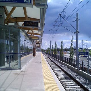
Edmonton Light Rail Transit, commonly referred to as the LRT, is a light rail system in Edmonton, Alberta. Part of the Edmonton Transit Service (ETS), the system has 18 stations on two lines and 24.3 km (15.1 mi) of track. As of 2018, it is one of the busiest light rail transit systems in North America, with over 110,000 daily weekday riders, and has been growing steadily in recent years.

Clareview station Light rail station in Edmonton, Alberta, Canada

Clareview station is an Edmonton Light Rail Transit station in Edmonton, Alberta, Canada. It serves the Capital Line and is currently the northern terminus of the line. It is a ground-level station located near 42 Street and 139 Avenue, and is named for the northeast Edmonton district of Clareview.

Belvedere station (Edmonton) Light rail station in Edmonton, Alberta, Canada

Belvedere station is an Edmonton Light Rail Transit in Edmonton, Alberta. It serves the Capital Line. It is a ground-level station located at Fort Road and 129 Avenue.

Coliseum station (Edmonton) Light rail station in Edmonton, Alberta, Canada

Coliseum station is an Edmonton Light Rail Transit station in Edmonton, Alberta, Canada. It serves the Capital Line. It is located at 78 Street and 118 Avenue, near Northlands Coliseum, and is built on an overpass above 118 Avenue.

Churchill station (Edmonton) Light rail station in Edmonton, Alberta, Canada

Churchill station is an Edmonton Light Rail Transit station in Edmonton, Alberta. It serves both the Capital Line and the Metro Line. It is an underground station located beneath Churchill Square and is a part of the Edmonton Pedway system.

Central station (Edmonton) Light rail station in Edmonton, Alberta, Canada

Central station is an Edmonton Light Rail Transit station in Edmonton, Alberta, Canada. It serves both the Capital Line and the Metro Line. It is an underground station located beneath Jasper Avenue between 100 Street and 101 Street.

Bay/Enterprise Square station Light rail station in Edmonton, Alberta, Canada

Bay/Enterprise Square station is an Edmonton Light Rail Transit station in Edmonton, Alberta, Canada. It serves both the Capital Line and the Metro Line. It is an underground station located beneath Jasper Avenue between 103 Street and 104 Street in downtown Edmonton. It is named for both the former Hudson's Bay Company store and Enterprise Square, the University of Alberta's downtown campus.

Corona station (Edmonton) Light rail station in Edmonton, Alberta, Canada

Corona station is an Edmonton Light Rail Transit station in Edmonton, Alberta, Canada. It serves both the Capital Line and the Metro Line. It is an underground station located beneath Jasper Avenue between 107 Street and 108 Street. It is the closest station to NorQuest College.

University station (Edmonton) Light rail station in Edmonton, Alberta, Canada

University station is an Edmonton Light Rail Transit station in Edmonton, Alberta, Canada. It serves both the Capital Line and the Metro Line. It is an underground station located beneath 112 Street at 89 Avenue on the University of Alberta campus. As of 2017, it is the busiest LRT station of the Capital and Metro lines with typical weekday traffic averaging 27,394 passengers.

Health Sciences/Jubilee station Light rail station in Edmonton, Alberta, Canada

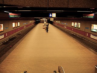
Health Sciences/Jubilee station is an Edmonton Light Rail Transit station in Edmonton, Alberta, Canada. It serves both the Capital Line and the Metro Line. It is a ground-level station located at 114 Street at 83 Avenue on the University of Alberta's main campus.

South Campus/Fort Edmonton Park station Light rail station in Edmonton, Alberta

South Campus/Fort Edmonton Park station is an Edmonton Light Rail Transit station in Edmonton, Alberta. It is served by the Capital Line and the Metro Line during peak hours. It is a ground-level station located on the University of Alberta's South Campus approximately two blocks to the west of the site originally proposed for the station on 113 Street.

Southgate station (Edmonton) Light rail station in Edmonton, Alberta

Southgate station is an Edmonton Light Rail Transit station in Edmonton, Alberta. It is served by the Capital Line and the Metro Line during peak hours. It is a ground-level station located next to the Southgate Centre shopping mall and the Southgate Transit Centre at 51 Avenue and 111 Street.

Downtown Edmonton Neighbourhood in Edmonton, Alberta, Canada

Downtown Edmonton is the central business district of Edmonton, Alberta. Located at the geographical centre of the city, the downtown area is bounded by 109 Street to the west, 105 Avenue to the north, 97 Street to the east, 97 Avenue and Rossdale Road to the south, and the North Saskatchewan River to the southeast.

The city of Edmonton, Alberta, has a transportation network fairly typical for a Canadian city of its size, involving most modes of transport including, but certainly not limited to, air, rail, road and public transit. 8 With very few natural barriers to growth and largely flat to gently rolling terrain bisected by a deep river valley, the city of Edmonton has expanded to cover an area of nearly 768 km2 (297 sq mi), of which only two-thirds is built-up, while the metropolitan area covers around 9,430 km2 (3,640 sq mi). This has resulted in a heavily private transportation-oriented transportation network typical of any other city of its size in North America. However, Edmonton does not have the extensive limited access freeway system typical of what one would find in a US metro area, and the road network is somewhat unusual in regard to access to downtown.

Edmonton Pedway Skyway and pedestrian tunnel network in Edmonton, Alberta, Canada

The Edmonton Pedway system is a network connecting office buildings, shopping centres, and parkades in downtown Edmonton, Alberta, Canada. It consists of approximately 13 kilometres (8.1 mi) of year-round climate-controlled tunnels, and walkways between the second floors of buildings, approximately 15 feet (4.6 m) above ground. The main network connects more than 40 buildings and parkades, and three of the five Edmonton Light Rail Transit (LRT) stations in the downtown area.

Dudley B. Menzies Bridge

The Dudley B. Menzies Bridge is a dedicated LRT bridge crossing the North Saskatchewan River in Edmonton, Alberta, Canada. Named after Edmonton engineer and politician Dudley Blair Menzies, the bridge was the "first concrete segmental box girder bridge in Western Canada". The main deck carries two tracks of the LRT system connecting Grandin/Government Centre station and the University station. A walkway for pedestrians and bicycles hangs beneath the main spans of the bridge over the river.

Kingsway/Royal Alex station Light rail station in Edmonton, Alberta, Canada

Kingsway/Royal Alex station is an Edmonton Light Rail Transit station in Edmonton, Alberta. It serves the Metro Line. It is located adjacent to the Royal Alexandra Hospital on the north side of Kingsway. The Kingsway/Royal Alex Transit Centre, constructed at the same time, is located next to the station.

Capital Line Light rail line in Edmonton, Alberta, Canada

The Edmonton LRT Capital Line is a light rail transit line running from northeast Edmonton to the south. Operated by the Edmonton Transit Service, the line provides access to Downtown Edmonton and the University of Alberta. The Capital Line currently consists of fifteen stations, six of which are underground. Seven stations are shared with the Metro Line.

References

  1. "SD160 Light Rail Vehicle" (PDF). Siemens Transportation Systems, Inc. May 2007. Archived from the original (PDF) on 26 October 2010. Retrieved 1 August 2014.
  2. "2019 LRT Passenger Count Report" (PDF). City of Edmonton. April 2020. Retrieved 5 February 2021.
  3. "LRT Brochure" (PDF). 15 November 2004. Archived from the original (PDF) on 4 January 2007. Retrieved 30 November 2011.
  4. Dudley Menzies Bridge – Light Rail Transit Bridge Over The North Saskatchewan River Archived 16 July 2011 at the Wayback Machine
  5. https://www.cbc.ca/news/canada/edmonton/edmonton-city-council-votes-to-rename-grandin-lrt-station-cover-mural-of-bishop-1.6057068
  6. City of Edmonton (July 2011). "LRT Design Guidelines 2011" (PDF). City of Edmonton. p. 700. Archived from the original (PDF) on 9 May 2015. Retrieved 30 May 2012.
  7. http://www.edmonton.ca/transportation/ets/alerts_routes_schedules_maps/grandingovernment-centre-stati.aspx
  8. "Contentious Grandin Station mural to be revised". Edmonton Journal , 27 February 2014.
  9. https://www.cbc.ca/news/canada/edmonton/edmonton-city-council-votes-to-rename-grandin-lrt-station-cover-mural-of-bishop-1.6057068
  10. "Government Centre Transit Centre Map" (PDF). City of Edmonton. Retrieved 28 April 2019.
  11. "Government Centre Transit Centre". City of Edmonton. Retrieved 28 September 2017.
  12. "Brochures in PDF". City of Edmonton. Retrieved 7 November 2019.
  13. "Schedules & Routes". Strathcona County. Retrieved 2 December 2018.
  14. "Commuter Routes". City of St. Albert. Retrieved 2 December 2018.