Grandview/Thorpe, Spokane

Last updated
Grandview/Thorpe
Grandview Thorpe Road.png
Welcome to Spokane sign on Thrope Road
Grandview-Thorpecropped.png
Location within the city of Spokane
Coordinates: 47°38′20.1″N117°27′35.9″W / 47.638917°N 117.459972°W / 47.638917; -117.459972
CountryUnited States
StateWashington
County Spokane
CitySpokane
Population
 (2017 [1] )
  Total1,448
Demographics 2017 [1]
   White 90.2%
  Latinx4.2%
  Asian/Native Hawaiian/Pacific Islander3%
  Black1.3%
  American Indian/Alaska Native0.8%
Time zone UTC-8 (PST)
  Summer (DST) UTC-7 (PDT)
ZIP Codes
99224
Area code 509

Grandview/Thorpe is a neighborhood in Spokane, Washington. Located in southwestern Spokane, the neighborhood takes its name from two roads that pass through. Grandview Boulevard, so named because of its location at the top of a ridge from which large swaths of Spokane, the Spokane Valley and surrounding mountains to the north and east such as Mount Spokane, can be seen, is located in the northern part of the neighborhood. Thorpe Road traverses a gully in the central and southern portion of the neighborhood.

Contents

The neighborhood's topography is a defining feature, as evidenced by the name Grandview. Interstate 90 descends into the Spokane Valley through the Garden Springs Creek drainage in the north, and Highway 195 travels into the city through the deep valley of Latah Creek to the east. These hills, and the limited access roadways that bound the neighborhood to the north and east, isolate Grandview/Thorpe from the rest of the city. Though the bulk of the neighborhood was annexed into the city by 1907, development was slow and much of Grandview/Thorpe, especially in the south, remains undeveloped. The areas that have been developed are entirely residential, and almost entirely single-family residential. [2]

Geography

I-90 descending Sunset Hill, with Grandview/Thorpe to the right Nighttime view of I-90 in Spokane, from Sunset Hill.jpg
I-90 descending Sunset Hill, with Grandview/Thorpe to the right

Grandview/Thorpe is located in the southwest corner of the city, with the city limits defining the neighborhood's western and southern bounds. Interstate 90 is the border to the north, across which lies the West Hills neighborhood. Interstate 90 descends from the elevation of the relatively flat Columbia Plateau on the west into the lower Spokane Valley below along what is locally known as Sunset Hill. [3] Highway 195 and the BNSF Railway's Northern Transcon tracks define the border on the east, separating Grandview/Thorpe from the Latah/Hangman neighborhood. [4] The interchange where I-90 and Highway 195 meet marks the northeastern corner of the neighborhood. There, the elevation is 1900 feet above sea level. Steep hillsides rise to 2200 feet, with Grandview Boulevard running along their crest. [5] Most of the developed area of Grandview/Thorpe is located in the Grandview area atop the hill. There are smaller residential areas on the relatively flat but small areas at the base of the hill. [2]

Garden Springs Creek briefly passes through the northern corner of the neighborhood, passing under I-90 at Rosamond Avenue. It then passes under Highway 195 near Lindeke Street, shortly before it empties into Latah Creek to the east. [5]

The area south of what would be roughly 25th Avenue, all the way to what would be 44th Avenue and the city limits, is far less developed than the northern Grandview section. There are some farms here, and homes are located on large lots with many tall ponderosa pines. [2]

Grandview/Thorpe straddles the boundary between two ecoregions as defined by the World Wildlife Fund. The lower and easternmost portions of the neighborhood, like almost all of the rest of the city, lie within the Okanagan dry forests ecoregion, which stretches from just south of Spokane northwest through the Okanagan and into the Thompson Plateau of British Columbia. Tall ponderosa pine trees are a remnant of the pre-development nature of the ecoregion. As one heads west from the crest of the hill the Okanagan dry forests transition into the Palouse grasslands. [6]

History

The Spokane people inhabited the area that is now Grandview/Thorpe for centuries before European settlers arrived. [7]

Almost all of the neighborhood was incorporated into the city in two separate annexations. In 1891 the northern half was annexed into the city, and in 1907 the southern half was annexed. [8] By 1900, several residential areas had been laid out, though they remained largely undeveloped and lightly populated. Streetcar and trolley lines connected the neighborhood with the rest of the city in 1904, and served the neighborhood until 1922. What little real estate development occurred in Grandview/Thorpe during those early decades of the 20th century took place along the streetcar lines. [2]

A development around 14th Avenue and D Street was used to house noncommissioned officers of the U.S. Army during World War II, though much of the area was later demolished as Interstate 90 was built through the neighborhood. [2]

In 1963 Grandview and 17th Avenues were paved, and by the 1970s the Grandview area had been connected to the city's sewer system. This helped spur development of the area. Many of the neighborhood's homes are characteristic of the 1970s and built as split-levels. [2] Growth has continued slowly but steadily since the arrival of paved roads and sewers. Grandview Park was developed in the 1990s at 17th Avenue and D Street. [9] [2]

As of the 2020s, continued growth in Grandview/Thorpe is point of contention. Some residents oppose new development on the grounds that it will alter the bucolic nature of the neighborhood, disrupting the area's connection with the natural environment and wildlife. [10] There are also concerns about increased traffic, which are shared not just by residents but the Washington State Department of Transportation as well. In February 2020, the state sent a letter to the city asking for a moratorium on new development citing issues with increased traffic and the neighborhood's lack of roads leading in and out. [11]

Transportation

Interstate

Interstate 90 connects to Grandview/Thorpe via U.S. 195 in the northeastern corner of the neighborhood, and via the Garden Springs Exit on the western edge of the neighborhood.

Highway

Highway 195 connects to Grandview/Thorpe via exits at Thorpe Road and 16th Avenue.

Surface streets

Thorpe Road is the only arterial in the neighborhood, officially designated as a minor arterial by the city. Grandview Avenue is designated as a major collector, which is between an arterial and a local-access street, as is the 16th Avenue/Milton Street/14th Avenue/Lindeke Street which connects to Grandview on the east, and the Garden Springs Road/Rustle Road corridor which connects to Grandview on the west. Those are the only two surface street connections between the Grandview area and the rest of the city of Spokane. All other roads in the neighborhood either do not connect with the city, or connect to it via Highway 195. [12]

There are no dedicated bike lanes in the neighborhood, but Grandview and 16th Avenues are designated as shared roadway bike routes. [13]

From west to east, Rustle Road, Rosamond Avenue and Lindeke Street cross over Interstate 90 into the West Hills neighborhood. [12]

Education

There are no schools in Grandview/Thorpe, nor are there any in the adjacent West Hills or Latah/Hangman neighborhoods. North of Thorpe Road, the neighborhood is part of the Hutton Elementary School district. Hutton is located in the Rockwood neighborhood, and its district immediately surrounding the school is not contiguous with Grandview/Thorpe. South of Thorpe the neighborhood lies in the Wilson Elementary School district. While Wilson is located in the Manito/Cannon Hill neighborhood, which is not contiguous with Grandview/Thorpe, the Wilson district is contiguous with the neighborhood south of Thorpe. [14]

As of 2022, both the Hutton and Wilson districts in Grandview/Thorpe feed into Sacajawea Middle School in the Comstock neighborhood. Starting in 2024, once construction is complete, both districts in Grandview/Thorpe will feed into the new Carla Peperzak Middle School south of the Southgate neighborhood. Though the areas of those districts outside of the neighborhood will continue to feed into Sacajawea. [14]

Grandview/Thorpe is part of the Lewis and Clark High School district. [15]

Demographics

As of 2017 the population of Grandview/Thorpe was 1,448 residents in 653 households. 46.5% of households were rented, compared to 45.3% citywide, and 28.2% of households had children. The median household income was $55,491, compared to $44,768 citywide. 41% of residents had a bachelor's degree or above while 21.3% had only a high school diploma. People aged 19 and under made up 20.5% of the population, compared to 21.9% citywide. Persons aged 65 and above made up 14.3% of the population, compared to 14.5% citywide. Persons of color made up 20.9% of the population, above the 15.1% mark citywide. 92.4% of residents were born in the United States or its territories. Of those not born in the U.S., 20.7% are from Ukraine, 19.5% from India, 12.2% from Canada and 5.2% from Russia. [1]

Related Research Articles

<span class="mw-page-title-main">Hillyard, Spokane</span> Neighborhood of Spokane in Spokane County, Washington, United States

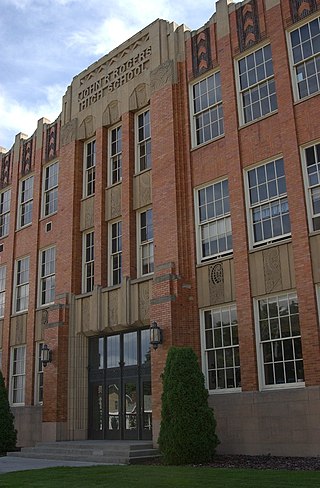
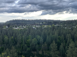
Hillyard is a neighborhood in Spokane, Washington which existed as a separate town between 1892 and 1924.

<span class="mw-page-title-main">Neighborhoods in Spokane, Washington</span>

Neighborhoods in Spokane, Washington are officially grouped by the Spokane City Council into three main city council districts: 1, 2, and 3. Each city council district contains multiple, official neighborhoods that are recognized with a neighborhood council. Informally, neighborhoods are colloquially grouped by local geographical, geological, cultural, or historical features The list of neighborhoods below is organized based on the official designations by the City of Spokane. Unofficial neighborhoods and districts are listed within the official neighborhood in which they are located.

<span class="mw-page-title-main">Bemiss, Spokane</span> Neighborhood in Spokane, Washington, United States

Bemiss is a neighborhood in Spokane, Washington. It is located within City Council District 1, which covers the northeastern section of the city. The neighborhood is bounded by Wellesley Avenue to the north, Market Street to the east, Illinois Avenue and the Spokane River to the south, and Perry Street and Napa Street to the west. It is located to the southeast of the Hillyard neighborhood and is often grouped into greater Hillyard.

<span class="mw-page-title-main">Chief Garry Park, Spokane</span> Neighborhood in Spokane, Washington, United States

Chief Garry Park is a neighborhood in Spokane, Washington. It is located immediately south of the Spokane River. It is named for Spokane Garry and a park that has taken his name. The neighborhood was first established in 1912 but it wasn't until 1932 that it was officially named for Chief Garry.

<span class="mw-page-title-main">Logan, Spokane</span> Spokane Neighborhood in Washington, United States

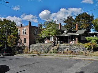
Logan is a neighborhood in Spokane, Washington. It is located immediately northeast of Downtown Spokane and is home to Gonzaga University. The Spokane River runs along its eastern and southern edge. Due to its proximity to the city center, Logan is home to some of the oldest and densest areas in the city. It is known for its tree-lined streets, historic buildings and population of college students. In addition to numerous individual properties, there are two historic districts listed on the National Register of Historic Places located within Logan: the Desmet Avenue Warehouse Historic District and the Mission Avenue Historic District.

<span class="mw-page-title-main">Browne's Addition, Spokane</span> Spokane Neighborhood in Washington, United States

Browne's Addition, often referred to shorthand as just Browne's, is a neighborhood in Spokane, Washington. It is located directly west of Downtown Spokane and is one of the oldest and densest neighborhoods in the city. The area is known for its numerous historic mansions, many of which have been converted into multi-family apartments. The terrain is flat in the neighborhood despite the degree of topographical relief in the immediate surrounding area. Latah Creek cuts a deep valley to the west, separating Browne's Addition from the Sunset Hill portion of the West Hills neighborhood and the Spokane River gorge drops off dramatically to the north into the Peaceful Valley neighborhood. The South Hill area of Spokane rises to the southwest.

<span class="mw-page-title-main">Peaceful Valley, Spokane</span> Spokane Neighborhood in Washington, United States

Peaceful Valley is a neighborhood in Spokane, Washington. It sits directly below Downtown Spokane on the Spokane River under its falls. The neighborhood snakes along the thin floodplain on the valley floor of the Spokane River Gorge. It is the smallest neighborhood in the city by both area and population, but due to its central location and unique character it is quite notable. The neighborhood has a working class and bohemian culture.

<span class="mw-page-title-main">Manito/Cannon Hill, Spokane</span> Neighborhood in Spokane, Washington, United States

Manito/Cannon Hill is a neighborhood on the South Hill of Spokane, Washington. It is named after the two public parks that dominate its setting: Manito Park and Cannon Hill Park. Manito/Cannon Hill is a predominantly residential neighborhood made up mostly by single-family homes and city park land.

<span class="mw-page-title-main">Cliff/Cannon, Spokane</span> Neighborhood in Spokane, Washington, United States

Cliff/Cannon is a neighborhood in Spokane, Washington. It is located immediately south of Downtown, Spokane, and on the lower reaches of the broader South Hill. The neighborhood is home to a medical district with Sacred Heart and Deaconess both having their main hospital campuses along Cliff/Cannon's denser northern edge. To the south the neighborhood becomes more residential. City parks break up the residential zoning of the southern half of Cliff/Cannon. It is adjacent to the Cannon Hill area of the neighboring but separate Manito/Cannon Hill neighborhood. The Marycliff-Cliff Park Historic District, a National Historic District listed on the National Register of Historic Places, is located within the neighborhood.

<span class="mw-page-title-main">Latah/Hangman, Spokane</span> Spokane Neighborhood in Washington, United States

Latah/Hangman is a neighborhood in Spokane, Washington.

<span class="mw-page-title-main">Emerson/Garfield, Spokane</span> Spokane Neighborhood in Washington, United States

Emerson/Garfield is a neighborhood in Spokane, Washington. It is located immediately north of Downtown Spokane's North Bank and extends out into the inner northwestern portion of the city. Emerson/Garfield is a diverse neighborhood with residential, commercial and civic zones all bordering one another, with density ranging from single-family homes to multi-use buildings. Due to its location in the central area of Spokane, Emerson/Garfield is criss-crossed by numerous arterials and thoroughfares. Along those main roads are numerous commercial and retail districts of importance to both the neighborhood and city as a whole.

<span class="mw-page-title-main">Comstock, Spokane</span> Neighborhood in Washington, United States

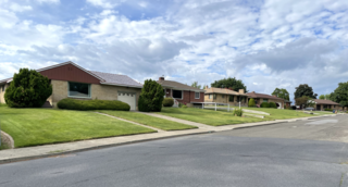
Comstock is a neighborhood in Spokane, Washington. It is located on the south side of the city in a broader area commonly known as the South Hill. The neighborhood is primarily single-family residential, and a mix of homes built during the streetcar era and then built during the post-World War II housing boom. The neighborhood is also home to a few commercial districts, including the regionally important Manito Shopping Center, two schools, the eponymous Comstock Park, sports fields and a golf course.

<span class="mw-page-title-main">Southgate, Spokane</span> Spokane Neighborhood in Washington, United States

Southgate is a neighborhood in Spokane, Washington. It is located in the southwestern corner of the City of Spokane and part of the broader area known locally as the South Hill. Southgate is one of the newer neighborhoods in the city, with development first taking hold in the post-World War II housing boom and continuing into the present day. It is a mix of single-family residential, multi-family residential and commercial districts. The neighborhood has grown as Spokane has expanded southward, with multiple annexations expanding Southgate and the city since 2000 and as recently as 2016.

<span class="mw-page-title-main">North Hill, Spokane</span> Spokane Neighborhood in Washington, United States

North Hill is a neighborhood in Spokane, Washington. As the name suggests, it is atop a hill on the north side of Spokane, within which it is centrally located and crossed by numerous major thoroughfares. It is home to parks, commercial districts and single family residential areas. The historic Garland Theater is located in North Hill, and the city's main north–south arterial, Division Street, is home to a major commercial district along the eastern edge of the neighborhood.

<span class="mw-page-title-main">West Hills, Spokane</span> Spokane Neighborhood in Washington, United States

West Hills is a neighborhood in Spokane, Washington. As the name suggests, the neighborhood is located on hillsides to the west of downtown Spokane. The neighborhood also extends far to the west along the West Plains to incorporate the Spokane International Airport and surrounding land. As the city has grown over the decades, the West Hills neighborhood has expanded uphill and onto the plains to the west. That history of incremental growth, combined with the hilly topography of the area cut by numerous watercourses, has broken up the neighborhood into multiple, distinct areas with swaths of undeveloped land mixed in between.

<span class="mw-page-title-main">Shiloh Hills, Spokane</span> Spokane Neighborhood in Washington, United States

Shiloh Hills is a neighborhood in Spokane, Washington, located on the far northeastern side of the city. It is one of the newer areas of the city, initially annexed in the late 1960s with growth continuing into the 21st century. The neighborhood is home to residential, commercial and industrial districts as well as multiple regionally important transportation corridors such as the Division Street "Y".

<span class="mw-page-title-main">Northwest, Spokane</span> Spokane Neighborhood in Washington, United States

Northwest is a neighborhood in Spokane, Washington, located in the northwestern portion of the city. Largely single-family residential, Northwest is also home to Spokane's VA Medical Center, the Dwight Merkel Sports complex, a large public sports facility, and portions of Riverside State Park along the Spokane River. The neighborhood contains developments that span from the post-World War II housing boom in the east to more contemporary, suburban-style developments in the west. It was also home to Joe Albi Stadium from 1950 until 2022, which served as the Spokane region's main high school sports stadium over its seven decades of use.

<span class="mw-page-title-main">Whitman, Spokane</span> Spokane Neighborhood in Washington, United States

Whitman is a neighborhood located on the northeast side of Spokane, Washington. It is named for pioneer missionaries Marcus and Narcissa Whitman.

<span class="mw-page-title-main">Sunset Boulevard Bridge</span> Bridge in Washington, U.S.

The Sunset Boulevard Bridge, also known as the Latah Creek Bridge, is a deck arch bridge in the northwestern United States that spans Latah Creek in Spokane, Washington. The bridge connects the neighborhoods of Browne's Addition on the east, and Downtown Spokane just beyond that, with West Hills to the west. Latah Creek, which passes under the bridge, separates the two neighborhoods. It was built 113 years ago in 1911 by the city of Spokane, and was designed by Morton McCartney & J.F. Cunningham, with J.F. Greene serving as the construction engineer.

<span class="mw-page-title-main">Garden Springs Creek</span> River in Washington, United States

Garden Springs Creek is a stream of approximately 1.5 miles in length that flows through the West Hills neighborhood of Spokane, Washington into Latah Creek.

References

  1. 1 2 3 "Grandview/Thorpe Neighborhood Snapshot" (PDF). spokanecity.org. City of Spokane. Retrieved 26 May 2022.
  2. 1 2 3 4 5 6 7 "Grandview-Thorpe Neighborhood Profile" (PDF). spokanecity.org. City of Spokane. Retrieved 26 May 2022.
  3. Epperly, Emma (10 November 2020). "Overnight snowfall creates slippery commute Tuesday morning". The Spokesman-Review. Retrieved 27 May 2022.
  4. "BNSF Network Map" (PDF). bnsf.com. BNSF Railway. Retrieved 26 May 2022.
  5. 1 2 "Spokane NW Quadrangle". usgs.gov. U.S. Geological Survey. Archived from the original on 3 May 2022. Retrieved 26 May 2022.
  6. "Terrestrial Ecoregions of the World". databasin.org. Conservation Biology Institute. Retrieved 14 June 2022.
  7. "History - Spokane Tribe of Indians". spokanetribe.com. Spokane Tribe of Indians. Retrieved 26 May 2022.
  8. "Annexation History". data-spokane.opendata.arcgis.com. City of Spokane. Retrieved 26 May 2022.
  9. Prager, Mike. "Grandview Residents Want Neighborhood Park". The Spokesman-Review. No. 22 May 1997. Retrieved 26 May 2022.
  10. McDermott, Ted (23 July 2021). "Latest Latah Valley development plan to be subject of community meeting". The Spokesman-Review. Retrieved 26 May 2022.
  11. Wohlfeil, Samantha (24 March 2022). "With limited access, neighbors and WSDOT both worry about proposed homes near Highway 195". The Inlander. Retrieved 26 May 2022.
  12. 1 2 "Official Arterial Street Map" (PDF). spokanecity.org. City of Spokane. Retrieved 27 May 2022.
  13. "Spokane Regional Bike Map". srtc.maps.arcgis.com. Spokane Regional Transportation Council. Retrieved 27 May 2022.
  14. 1 2 "Elementary Boundary Map" (PDF). spokaneschools.org. Spokane Public Schools. Retrieved 27 May 2022.
  15. "High School Boundary Map" (PDF). spokaneschools.org. Spokane Public Schools. Retrieved 27 May 2022.