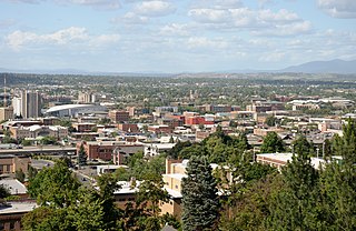
Rockwood, Spokane

Last updated
Rockwood
Cathedral of St. John in Spokane.jpg
St. John's Cathedral in Rockwood
Rockwoodcropped.png
Location within the city of Spokane
Coordinates: 47°37′56.9″N117°23′40.1″W / 47.632472°N 117.394472°W / 47.632472; -117.394472
CountryUnited States
StateWashington
County Spokane
CitySpokane
Population
 (2017 [1] )
  Total4,337
Demographics 2017
   White 92.7%
  Latinx3.7%
  Asian1.8%
  American Indian1.1%
  Black0.8%
Time zone UTC-8 (PST)
  Summer (DST) UTC-7 (PDT)
ZIP Codes
99203 and 99202
Area code 509

Rockwood is a neighborhood in Spokane, Washington. It is located on the south side of the city to the southeast of Downtown Spokane and expanding southeasterly from close to the city center. Its proximity to downtown makes it one of Spokane's older neighborhoods, with mature trees lining most of its streets. Due to its location on the hill leading up from the Spokane River Valley, the street grid breaks down in many places around Rockwood. The most notable of these is along the winding Rockwood Boulevard, which was designed by the Olmsted Brothers and weaves its way from the northwesternmost corner of the neighborhood through the center and across to the eastern border, highlighting the basalt bluffs and other natural topography.

Contents

It is one of the more affluent neighborhoods in the Spokane community. Many old, large homes are located in Rockwood, especially in the Rockwood Historic District. Unlike many of the other old neighborhoods surrounding the Spokane city center, the vast majority of the large homes in Rockwood continue to serve as single-family housing.

Geography

Rockwood Boulevard at 12th Avenue in autumn Rockwood Boulevard Spokane.png
Rockwood Boulevard at 12th Avenue in autumn

Grand Boulevard, a major north-south thoroughfare, is the neighborhood's western boundary and 29th street, a major east-west thoroughfare, bounds Rockwood on the south. Southeast Boulevard serves as the majority of the neighborhood's eastern and northern boundaries. Between Grand and Southeast Boulevards, about five block lengths of side streets act as the boundary between Rockwood on the south and East Central to the north.

Within the neighborhood is the Rockwood Historic District, which is listed on the National Register of Historic Places. The district is about two blocks wide between Hatch and Arthur streets from 29th Avenue on the south to 14th Avenue on the north, from which it continues turns to the northwest and continues to the northwesternmost corner of the neighborhood. [2] This area of the neighborhood was designed by noted landscape architects, the Olmsted Brothers. [3] It features streets that curve around exposed basalt outcroppings and through old ponderosa pine and Douglas fir forest as they wind their way up the hill from downtown. The Olmsteds were fond of diagonal streets such as Southeast Boulevard that borders the neighborhood. The Rockwood neighborhood borders two of the city's larger parks, Manito Park to the west and Lincoln Park to the east, but does not contain any true parks within its boundaries. [4] However, in the Rockwood Historic Districts, four small grassy islands are located on Garfield Road and Rockwood Boulevard, known as the Olmsted Triangle Parks, as well as a pair of grassy boulevards that intersect at the intersection of Upper Terrace Road and Rockwood and Highland Boulevards. [5] [6] The neighborhood's terrain is reflected in many of the street names, like the aforementioned Rockwood, Highland and Upper Terrace, as well as Crest Road and Overbluff Drive. [7]

The neighborhood is overwhelmingly residential, though commercial districts exist in the northwest along Grand Boulevard extending north from 14th Avenue and in the southeast along 29th Avenue from Pittsburgh Street and extending east into the Lincoln Heights neighborhood. [4] Hutton Elementary School is located in the middle of the neighborhood at 24th Avenue and Plateau Road. [5]

History

Stone towers topped with bird houses mark the entrance to the Rockwood Historic District on Highland Boulevard Highland Boulevard Towers.png
Stone towers topped with bird houses mark the entrance to the Rockwood Historic District on Highland Boulevard

In the 1880s, Rockwood was known as Montrose for the hilly terrain and patches of wild roses growing in the area. Frances Cook, one of the first European settlers in the area, owned much of the land now part of Rockwood. Cook laid a streetcar line into the neighborhood, and had plans for more development, but he was forced to sell his holdings during the Panic of 1893. Development of the neighborhood continued when mining magnate Jay P. Graves acquired much of the Cook's land and extended streetcar service through the area. [5]

The neighborhood began to take on its current form in 1907, when the Olmsted Brothers were hired to plan and design the Rockwood area. Their plan was funded for $1 million in 1910. This area is now preserved as the Rockwood Historic District and is known for its tree-lined streets and large homes set well back from the curb. [5]

Intersection of Rockwood and Highland Boulevards and Upper Terrace Drive Rockwood in Spring.png
Intersection of Rockwood and Highland Boulevards and Upper Terrace Drive

With the neighborhood experiencing rapid growth and development in the second decade of the 20th century, there became the need for a school in Rockwood. A one-room school was built in 1917, and soon replaced by a much larger facility. In 1920, Hutton School was built in the south-central area of the neighborhood. It was designed in a Spanish eclectic style, with stucco walls, red tile roofing, arched entryways and windows, and exposed wooden beams. The school has subsequently been expanded on three occasions, in 1949 and 1956, and then in 2015 when the 1949 and 1956 expansions were removed and replaced with a new, two-story structure for cost of $29 million. The historic 1921 building remains intact and contains the main entrance, library, offices and some classrooms. The building was listed on the Spokane Register of Historic Places in 2015. [8]

Cathedral of St. John the Evangelist Spokane Storm (HDR) (3533336289).jpg
Cathedral of St. John the Evangelist

Construction on neighborhood's most iconic structure, St. John's Cathedral, began in 1925 on a bluff in Rockwood's far northwestern corner. [9] The 180 foot tall Gothic Revival structure is built entirely from cut stone. Its height, combined with its setting on a bluff at the crest of the steep hill leading up from Downtown, makes the cathedral a landmark visible from areas to the north, east and west.

Streetcars connected Rockwood with the rest of the city until 1935, when the service was abandoned citywide. Remnants of the streetcar era are still visible in places along the former route, which followed Rockwood Boulevard. The grassy median on the south and west side of the winding road was once the streetcar platform. The median retains the step-up appearance of the former platform. [5]

In 1997, the older portions of Rockwood were added to the National Register of Historic Places (NRHP) as the Rockwood Historic District.

Historic places

In addition to the Rockwood Historic District, the Rockwood neighborhood is home to 3 other properties listed on the NRHP on their own merit.

[10] Name on the RegisterImageDate listed [11] LocationDescription
1 George and Blanche Christiansen House
George and Blanche Christiansen House Christiansen House NRHP 15000881 Spokane County, WA.jpg
George and Blanche Christiansen House
December 8, 2015
(#15000881)
1329 E. Overbluff Rd.
47°38′09″N117°23′25″W / 47.635796°N 117.390333°W / 47.635796; -117.390333 (George and Blanche Christiansen House)
Built in 1926
2 McMillen-Dyar House
McMillen-Dyar House McMillen-Dyar House, Spokane, WA.jpg
McMillen-Dyar House
August 26, 2019
(#100004330)
526 E 12th Ave.
47°38′39″N117°24′11″W / 47.6442°N 117.4031°W / 47.6442; -117.4031 (McMillen-Dyar House)
3 William and Margaret Solby House
William and Margaret Solby House Solby House NRHP 07000831 Spokane County, WA.jpg
William and Margaret Solby House
August 16, 2007
(#07000831)
1325 E. 20th Ave.
47°38′20″N117°23′25″W / 47.638889°N 117.390278°W / 47.638889; -117.390278 (William and Margaret Solby House)
Built in 1926.

Demographics

As of 2017, 4,337 people live in Rockwood across 1,855 households. Of those households, 25.8% are rented, well below the citywide average of 45.3%. 31.5% of residents are age 19 or younger while 19.1% are aged 65 or above. The median household income is $87,201, nearly double the citywide figure of $44,768. Residents with a bachelor's degree or higher account for 67.5% of Rockwood residents while those with a high school diploma or less account for 8.2%. 92.4% of residents were born in the United States or one of its territories. Among foreign-born residents, Canada accounts for the most at 25.6%, followed by the Philippines at 11%, Ukraine at 9.8% and Hungary at 7.6%. [1]

Education

Hutton Elementary School Hutton Elementary Spokane.png
Hutton Elementary School

Rockwood is home to Hutton Elementary School, a public school in the Spokane Public Schools district. Hutton serves most of the neighborhood, though not all. In the northwest, 19th Avenue, Latawah Street and 17th Avenue separate the Hutton district from that of Roosevelt Elementary School, located in the adjacent Cliff/Cannon neighborhood. The areas north of 17th Avenue and east of Rockwood Boulevard are part of the Grant Elementary School district, located in the adjacent South Perry District. [12]

Hutton, Roosevelt and Grant Elementaries all feed into Sacajawea Middle School, located in the adjacent Comstock neighborhood, which then feeds into Lewis and Clark High School in the adjacent Cliff/Cannon neighborhood. [13]

Transportation

Rockwood Boulevard in winter Rockwood Blvd Winter - panoramio.jpg
Rockwood Boulevard in winter

Surface Streets

Grand Boulevard and 29th Avenue are considered urban principle arterials, the highest classification in the city for non-limited access roadways. Southeast Boulevard is classified as an urban minor arterial. Rockwood Boulevard is classified as a major urban collector, a level between arterials and local access roads. [14]

Bicycle routes run along Southeast Boulevard, which has a dedicated bike lane. A shared roadway bicycle route runs from Rockwood's southern boundary at Arthur Street south to Plateau Road, Garfield Road and Upper Terrace Road. [15]

Public Transit

The Spokane Transit Authority, the region's public transportation provider, serves Rockwood with seven fixed schedule bus lines. [16]

RouteTerminiService operation and notesStreets traveled
4
Moran Prairie
Downtown Spokane
STA Plaza
Glenrose
Moran Station Park & Ride
High-frequency routeGrand Boulevard, 29th Avenue
45
Perry District
Downtown Spokane
STA Plaza
Lincoln Heights
South Hill Park & Ride
Basic-frequency routeSoutheast Boulevard

Both routes passing through Rockwood serve the South Hill Park and Ride center, which is located two blocks south of Rockwood's southeasternmost point. Route 12, the Southside Medical Shuttle, has a stop across the street from Rockwood's northernmost point, but does not pass through the neighborhood directly. [17]

Related Research Articles

<span class="mw-page-title-main">Hillyard, Spokane</span> Neighborhood of Spokane in Spokane County, Washington, United States

Hillyard is a neighborhood in Spokane, Washington which existed as a separate town between 1892 and 1924.

<span class="mw-page-title-main">Bemiss, Spokane</span> Neighborhood in Spokane, Washington, United States

Bemiss is a neighborhood in Spokane, Washington. It is located within City Council District 1, which covers the northeastern section of the city. The neighborhood is bounded by Wellesley Avenue to the north, Market Street to the east, Illinois Avenue and the Spokane River to the south, and Perry Street and Napa Street to the west. It is located to the southeast of the Hillyard neighborhood and is often grouped into greater Hillyard.

<span class="mw-page-title-main">Chief Garry Park, Spokane</span> Neighborhood in Spokane, Washington, United States

Chief Garry Park is a neighborhood in Spokane, Washington. It is located immediately south of the Spokane River. It is named for Spokane Garry and a park that has taken his name. The neighborhood was first established in 1912 but it wasn't until 1932 that it was officially named for Chief Garry.

<span class="mw-page-title-main">Logan, Spokane</span> Spokane Neighborhood in Washington, United States

Logan is a neighborhood in Spokane, Washington. It is located immediately northeast of Downtown Spokane and is home to Gonzaga University. The Spokane River runs along its eastern and southern edge. Due to its proximity to the city center, Logan is home to some of the oldest and densest areas in the city. It is known for its tree-lined streets, historic buildings and population of college students. In addition to numerous individual properties, there are two historic districts listed on the National Register of Historic Places located within Logan: the Desmet Avenue Warehouse Historic District and the Mission Avenue Historic District.

<span class="mw-page-title-main">East Central, Spokane</span> Spokane Neighborhood in Washington, United States

East Central is a neighborhood in Spokane, Washington. As the name suggests, it is on the east side of Spokane and centrally located. The official neighborhood is expansive and covers multiple areas considered by locals to be independent neighborhoods, such as the Sprague Union District on East Sprague Avenue, the South Perry District, the Underhill Park area and the University District on the eastern fringe of Downtown Spokane.

<span class="mw-page-title-main">Browne's Addition, Spokane</span> Spokane Neighborhood in Washington, United States

Browne's Addition, often referred to shorthand as just Browne's, is a neighborhood in Spokane, Washington. It is located directly west of Downtown Spokane and is one of the oldest and densest neighborhoods in the city. The area is known for its numerous historic mansions, many of which have been converted into multi-family apartments. The terrain is flat in the neighborhood despite the degree of topographical relief in the immediate surrounding area. Latah Creek cuts a deep valley to the west, separating Browne's Addition from the Sunset Hill portion of the West Hills neighborhood and the Spokane River gorge drops off dramatically to the north into the Peaceful Valley neighborhood. The South Hill area of Spokane rises to the southwest.

<span class="mw-page-title-main">Manito/Cannon Hill, Spokane</span> Neighborhood in Spokane, Washington, United States

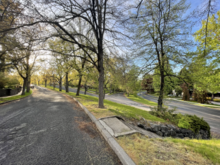
Manito/Cannon Hill is a neighborhood on the South Hill of Spokane, Washington. It is named after the two public parks that dominate its setting: Manito Park and Cannon Hill Park. Manito/Cannon Hill is a predominantly residential neighborhood made up mostly by single-family homes and city park land.

<span class="mw-page-title-main">Emerson/Garfield, Spokane</span> Spokane Neighborhood in Washington, United States

Emerson/Garfield is a neighborhood in Spokane, Washington. It is located immediately north of Downtown Spokane's North Bank and extends out into the inner northwestern portion of the city. Emerson/Garfield is a diverse neighborhood with residential, commercial and civic zones all bordering one another, with density ranging from single-family homes to multi-use buildings. Due to its location in the central area of Spokane, Emerson/Garfield is criss-crossed by numerous arterials and thoroughfares. Along those main roads are numerous commercial and retail districts of importance to both the neighborhood and city as a whole.

<span class="mw-page-title-main">Lincoln Heights, Spokane</span> Spokane Neighborhood in Washington, United States

Lincoln Heights is a neighborhood in Spokane, Washington. It is located in the southeastern portion of the city in a broader area commonly known as the South Hill. As the name suggests, Lincoln Heights lies on the slopes and atop the crest of the South Hill area. Lincoln Heights is home to a mix of single-family residential, multi-family residential, and commercial areas and a significant amount of park land. The Lincoln Heights Shopping Center and surrounding area is one of the largest and most important commercial and retail districts on the entire south side of Spokane.

<span class="mw-page-title-main">Comstock, Spokane</span> Neighborhood in Washington, United States

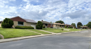
Comstock is a neighborhood in Spokane, Washington. It is located on the south side of the city in a broader area commonly known as the South Hill. The neighborhood is primarily single-family residential, and a mix of homes built during the streetcar era and then built during the post-World War II housing boom. The neighborhood is also home to a few commercial districts, including the regionally important Manito Shopping Center, two schools, the eponymous Comstock Park, sports fields and a golf course.

<span class="mw-page-title-main">Southgate, Spokane</span> Spokane Neighborhood in Washington, United States

Southgate is a neighborhood in Spokane, Washington. It is located in the southwestern corner of the City of Spokane and part of the broader area known locally as the South Hill. Southgate is one of the newer neighborhoods in the city, with development first taking hold in the post-World War II housing boom and continuing into the present day. It is a mix of single-family residential, multi-family residential and commercial districts. The neighborhood has grown as Spokane has expanded southward, with multiple annexations expanding Southgate and the city since 2000 and as recently as 2016.

<span class="mw-page-title-main">Grandview/Thorpe, Spokane</span> Spokane Neighborhood in Washington, United States

Grandview/Thorpe is a neighborhood in Spokane, Washington. Located in southwestern Spokane, the neighborhood takes its name from two roads that pass through. Grandview Boulevard, so named because of its location at the top of a ridge from which large swaths of Spokane, the Spokane Valley and surrounding mountains to the north and east such as Mount Spokane, can be seen, is located in the northern part of the neighborhood. Thorpe Road traverses a gully in the central and southern portion of the neighborhood.

<span class="mw-page-title-main">North Hill, Spokane</span> Spokane Neighborhood in Washington, United States

North Hill is a neighborhood in Spokane, Washington. As the name suggests, it is atop a hill on the north side of Spokane, within which it is centrally located and crossed by numerous major thoroughfares. It is home to parks, commercial districts and single family residential areas. The historic Garland Theater is located in North Hill, and the city's main north–south arterial, Division Street, is home to a major commercial district along the eastern edge of the neighborhood.

<span class="mw-page-title-main">West Hills, Spokane</span> Spokane Neighborhood in Washington, United States

West Hills is a neighborhood in Spokane, Washington. As the name suggests, the neighborhood is located on hillsides to the west of downtown Spokane. The neighborhood also extends far to the west along the West Plains to incorporate the Spokane International Airport and surrounding land. As the city has grown over the decades, the West Hills neighborhood has expanded uphill and onto the plains to the west. That history of incremental growth, combined with the hilly topography of the area cut by numerous watercourses, has broken up the neighborhood into multiple, distinct areas with swaths of undeveloped land mixed in between.

<span class="mw-page-title-main">Audubon/Downriver, Spokane</span> Spokane Neighborhood in Washington, United States

Audubon/Downriver is a neighborhood in Spokane, Washington, located on the northwest side of the city. There is a diversity of land use in the neighborhood, with single-family residential areas dating from the early 20th century through the Post–World War II economic expansion era, regionally important commercial districts, smaller neighborhood retail areas, numerous schools, large parks, a golf course, conservation areas and part of Riverside State Park along the Spokane River. The neighborhood is the site of the corporate offices for Rosauers Supermarkets, a regional grocery store chain with stores located across the Northwestern United States.

<span class="mw-page-title-main">Nevada Heights, Spokane</span> Spokane Neighborhood in Washington, United States

Nevada Heights is a neighborhood in Spokane, Washington, located on the north side of the city. Its southern border is atop a bluff that runs east–west across the north side of the city, which gives the neighborhood its name. Nevada Street, a major north–south arterial, runs through the neighborhood. The neighborhood is largely residential, but also home to large retail districts, medical facilities, schools and parks. Being surrounded by the city of Spokane on all sides, the neighborhood is well integrated into urban area.

<span class="mw-page-title-main">Shiloh Hills, Spokane</span> Spokane Neighborhood in Washington, United States

Shiloh Hills is a neighborhood in Spokane, Washington, located on the far northeastern side of the city. It is one of the newer areas of the city, initially annexed in the late 1960s with growth continuing into the 21st century. The neighborhood is home to residential, commercial and industrial districts as well as multiple regionally important transportation corridors such as the Division Street "Y".

<span class="mw-page-title-main">Northwest, Spokane</span> Spokane Neighborhood in Washington, United States

Northwest is a neighborhood in Spokane, Washington, located in the northwestern portion of the city. Largely single-family residential, Northwest is also home to Spokane's VA Medical Center, the Dwight Merkel Sports complex, a large public sports facility, and portions of Riverside State Park along the Spokane River. The neighborhood contains developments that span from the post-World War II housing boom in the east to more contemporary, suburban-style developments in the west. It was also home to Joe Albi Stadium from 1950 until 2022, which served as the Spokane region's main high school sports stadium over its seven decades of use.

<span class="mw-page-title-main">Whitman, Spokane</span> Spokane Neighborhood in Washington, United States

Whitman is a neighborhood located on the northeast side of Spokane, Washington. It is named for pioneer missionaries Marcus and Narcissa Whitman.

<span class="mw-page-title-main">Rockwood Historic District</span> Historic district in Spokane, Washington

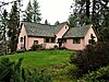
The Rockwood Historic District is a historic residential area in the Rockwood neighborhood on the south side of Spokane, Washington. The district was listed on the National Register of Historic Places (NRHP) in 1997 due to the concentration of historic homes within the district as well as its significance in the areas of architecture, landscape architecture, and community planning and development.

References

  1. 1 2 "Rockwood Neighborhood Snapshot" (PDF). spokanecity.org. City of Spokane. Retrieved 12 November 2021.
  2. "Rockwood District Map" (PDF). historicspokane.org. City - County of Spokane Historic Preservation Office. Retrieved 18 November 2021.
  3. Kershner, Jim (July 18, 2007). "Olmsted Parks in Spokane". HistoryLink. Retrieved February 3, 2022.
  4. 1 2 Camden, Jim (September 24, 2017). "29th Avenue anchors duo of historic neighborhoods". The Spokesman-Review. Retrieved August 6, 2023.
  5. 1 2 3 4 5 "Rockwood Neighborhood Profile" (PDF). spokanecity.org. City of Spokane. Retrieved 18 November 2021.
  6. "Rockwood Historic District". Historic Spokane. City - County of Spokane Historic Preservation Office. Retrieved 18 November 2021.
  7. Guilfoil, Michael (10 May 1996). "Paths To Our Past Spokane's Rockwood-Highland Area Entertains Mother's Day Historic Preservation Tour". The Spokesman-Review. Retrieved 19 November 2021.
  8. Prager, Mike (28 October 2015). "Hutton Elementary voted onto Spokane historic register". spokesmanreview.com. The Spokesman-Review. Retrieved 19 November 2021.
  9. Tinsley, Jesse (18 November 2013). "Then and Now photos: Cathedral of St. John the Evangelist". The Spokesman-Review. Retrieved 19 November 2021.
  10. Numbers represent an alphabetical ordering by significant words. Various colorings, defined here, differentiate National Historic Landmarks and historic districts from other NRHP buildings, structures, sites or objects.
  11. The eight-digit number below each date is the number assigned to each location in the National Register Information System database, which can be viewed by clicking the number.
  12. "Elementary School District Map" (PDF). spokaneschools.org. Spokane Public Schools. Retrieved 5 June 2022.
  13. "High School Boundary Map" (PDF). spokaneschools.org. Spokane Public Schools. Retrieved 5 June 2022.
  14. "Official Arterial Street Map 2021" (PDF). spokanecity.org. City of Spokane. Retrieved 6 May 2022.
  15. "Spokane Regional Bike Map". arcgis.com. City of Spokane, Spokane County. Retrieved 6 May 2022.
  16. "STA System Map" (PDF). spokanetransit.com. Spokane Transit Authority. Retrieved 18 June 2022.
  17. "STA System Map" (PDF). spokanetransit.com. Spokane Transit Authority. Retrieved 6 May 2022.