East Central, Spokane

Last updated
East Central
Sprague Ave International District E-bound.png
Sprague Union District
East Centralcropped.png
Location within the city of Spokane
Coordinates: 47°39′29.5″N117°22′22.5″W / 47.658194°N 117.372917°W / 47.658194; -117.372917
CountryUnited States
StateWashington
County Spokane
CitySpokane
Population
 (2017 [1] )
  Total12,126
Demographics 2017
   White 76.7%
  Black6.3%
  Latinx7.5%
  Asian5.0%
  Native American2.6%
Time zone UTC-8 (PST)
  Summer (DST) UTC-7 (PDT)
ZIP Codes
99202
Area code 509

East Central is a neighborhood in Spokane, Washington. As the name suggests, it is on the east side of Spokane and centrally located. The official neighborhood is expansive and covers multiple areas considered by locals to be independent neighborhoods, such as the Sprague Union District on East Sprague Avenue, [2] the South Perry District, [3] the Underhill Park area [4] and the University District on the eastern fringe of Downtown Spokane. [5]

Contents

Geography

The Ben Burr Trail is a greenway that lies in the center of the neighborhood BenBurrTrail.jpg
The Ben Burr Trail is a greenway that lies in the center of the neighborhood

East Central is officially bounded by Spokane Falls Boulevard and Trent Avenue in the north. Havana Street is its eastern boundary, also serving as the municipal border between the city of Spokane and the city of Spokane Valley. The southern boundary follows 13th Avenue west from Havana to Freya Street, then the Ben Burr Trail and Spokane Valley Bluff to Crestline Street, then 14th Avenue to Southeast Boulevard and 12th Avenue to Rockwood Boulevard. Rockwood Boulevard meets Cowley Street and the neighborhood boundary extends north. [6]

Districts

South Perry District

Cambern Dutch Shop Windmill in the South Perry District Windmill on Perry St.jpg
Cambern Dutch Shop Windmill in the South Perry District

Located in the southwestern corner of East Central, the South Perry District spills over into the Lincoln Heights and Rockwood neighborhoods. It is centered on a commercial district along Perry Street near Grant Park and Grant Elementary School. The district and surrounding area are located on the South Hill, as the area south of Downtown Spokane is known colloquially. [7] The stretch of Perry Street from 9th to 13th Avenues is home to numerous shops, bars, restaurants and retail stores. It is also the location of a weekly farmers' market during the spring, summer and fall. [8]

Liberty Park, a neighborhood landmark, is located on the northern edge of the South Perry District where it meets the Sprague Union District. [9]

Sprague Union District

Centered on East Sprague Avenue, the main surface thoroughfare extending eastward from downtown Spokane through the City of Spokane Valley, the Sprague Union District is equal parts an arterial meant for passing through and a district made to stop in. Sprague Avenue is the primary east-to-west surface street in the Spokane metropolitan area but here it is close enough to the city center that it is also a surface street used for local traffic. The area from Altamont Street on the east to Liberty Park on the west is historic and home to numerous antique stores, shops, restaurants, bars and apartments.

To the north of the neighborhood are the railroad tracks of the Spokane Subdivision and Interstate 90 passes through the area three blocks south of Sprague Avenue, cutting the Sprague Union District off from much of the rest of East Central.

Underhill Park

On the eastern side of East Central is Underhill Park, a property owned by the City of Spokane and operated as a public park on the slope leading up to the South Hill from the flat bottom of the Spokane Valley. This part of East Central is predominantly single-family residential, though a commercial district at the Thor/Freya exit from Interstate 90 is home to many services like gas and grocery. [4] Interstate 90 cuts through the area going east-to-west, separating it from the Sprague Union District of East Central to the north.

University District

The WSU Health Sciences campus in the University District WSU Health Sciences Spokane campus 2015.jpg
The WSU Health Sciences campus in the University District

Located directly east of Downtown Spokane, the University District is the westernmost portion of East Central. It stretches from Sprague Avenue in the south across the Spokane River into the Logan neighborhood to the north, with Division Street on the west separating it from downtown. Washington State University and Eastern Washington University have campuses in the East Central portion of the University District, while Gonzaga University lies across the river in Logan. This is the most directly connected portion of East Central to the city center of Spokane. [5] A pedestrian bridge leading from Sprague Avenue at Sherman Street was built in 2019 to connect the southern portion of the district with the main campus areas, which are separated by BNSF Railway that is impassable at surface level. The bridge, which boasts a 120 foot tall arch at its center, was named Project of the Year in 2021 by the American Public Works Association. [10] The pedestrian connection between the southern and northern portions of the district has helped spur multiple development projects in the formerly cut-off southern section. The Catalyst Building, adjacent to the bridge, was opened in 2020 is a net-zero emission building housing Eastern Washington University classrooms as well as environmental and technological research organizations. [11]

History

The abandoned McKinley School in the Sprague Union District. Abandoned McKinley School Spokane.png
The abandoned McKinley School in the Sprague Union District.

East Central was originally a working class suburb developed early on in Spokane's history, but successive bouts of bad economic luck hit the neighborhood following World War I, then during the Great Depression, and again in the 1950s. [12] During the 1920s, much effort was made by local entrepreneurs to capitalize on the neighborhoods advantageous position along Sprague Avenue and between downtown Spokane and the suburban farming communities of the Spokane Valley, developing a thriving commercial district for over two decades with many prominent businesses. [13] Italian and African American families were a relatively large demographic in the neighborhood in the first half of the 20th century. [13] Another major blow to the community came in 1965, when Interstate 90 was completed and effectively cut the neighborhood in half, and in the East Sprague Business District, also drew traffic and business off of Sprague Avenue. [13] Houses were razed and residents displaced, while churches and other community-building organizations and businesses were forced to close their doors. [14] Further difficulties came with the redevelopment of downtown Spokane in preparation for Expo '74, which saw heavy investment and cleaned up the streets in the Riverside neighborhood, including the city's then red light district centered on West Main Avenue which displaced many of the drug dealers, prostitutes, and transients into East Central along Sprague Avenue. [13] In the decades that followed, the neighborhood gained a stigma of poverty, prostitution and drug use, especially the northern section along Sprague Avenue that was cut off by I-90 from the rest of the neighborhood. [15] By the 1990s the East Sprague business district included a wide variety of businesses such as antique stores, bars, sex shops, strip clubs, and used car lots. [13] According to the Spokane Police Department, 80 percent of all prostitution arrests in the city from April 1996 to January 1998 were made between Havana and Division Street and I-90 and Main Avenue and the neighborhood received a lot of negative publicity following the murder of five sex workers that worked East Sprague by serial killer Robert Lee Yates from 1996-1998. [13]

Urban Renewal

South Perry District

In the first decade of the 2000s, city planners set their sights on urban renewal projects within the neighborhood. The first area targeted was the South Perry District. Street construction began in 2007 to install curb bump-outs at crosswalks and bus stops intended to slow traffic on Perry Street, as well as the planting of shade trees, pedestrian lights on the sidewalks, benches and other amenities. More than $900,000 was spent on the project. From 2009 through 2012, six new businesses opened on a stretch of Perry Street spanning from roughly eighth to 12th avenues. The businesses included restaurants, bars and boutiques, among other retailers. The four-plus block stretch of Perry Street quickly became a hub for residents of the immediate and surrounding neighborhood. [16]

In the years prior to the investments made by the city, the local community in the South Perry District had begun organizing community events like the weekly Thursday Market farmers market [17] and the annual South Perry Street Fair. [18]

East Sprague

After addressing the South Perry District, the city shifted its focus to the northern section of the neighborhood, on the other side of I-90. In 2013, city officials proposed taking the approach used in South Perry and applying it to East Sprague Avenue. [19] By late 2016, $17 million worth of investment was underway or planned in what the East Sprague business district began calling the "International District". [15] The city of Spokane would go on to spend $11 million on top of that to redevelop Sprague Avenue, much in the way it did with Perry Street. The roadway was reduced from two lanes in each direction to one, with a center turning lane. Bus stops were given curb kick-outs, which slowed traffic. Following the redevelopment, the district sought a more fitting name and rebranded itself again as the "Sprague Union District" in 2017, invoking a past when it was a manufacturing zone called "Union Park" in the late 19th and early 20th century and frequented by working-class immigrant laborers. [20] Sprague Avenue had long been a major arterial, and still is to this day, but speeds are slower and more emphasis is paid to those who are traveling into and out of the neighborhood than simply passing through it. The project, which spans from Division Street on the West, the neighborhood's border with Downtown Spokane, and Stone Street on the East, roughly two miles apart, was completed in late 2021. [21]

The process of urban renewal continues, however. Numerous abandoned buildings still dot the area surrounding Sprague Avenue as of November 2021, including the historic McKinley School pictured above. Plans to redevelop the structure have been floated and changed numerous times over recent years, but none have stuck. [22]

Historic places

East Central is home to seven properties listed on the National Register of Historic Places.

[23] Name on the RegisterImageDate listed [24] LocationDescription
1 Cambern Dutch Shop Windmill
Cambern Dutch Shop Windmill Windmill blades close-up.jpg
Cambern Dutch Shop Windmill
March 16, 1989
(#89000213)
S. 1102 Perry
47°38′43″N117°23′20″W / 47.645278°N 117.388889°W / 47.645278; -117.388889 (Cambern Dutch Shop Windmill)
Built circa 1929.
2 Dodd House
Dodd House Dodd House with commemorative marker.jpg
Dodd House
July 3, 2010
(#10000417)
603 S. Arthur St.
47°39′03″N117°23′41″W / 47.6508°N 117.3947°W / 47.6508; -117.3947 (Dodd House)
3 Frequency Changing Station
Frequency Changing Station Frequency Changing Station NRHP 79002556 Spokane County, WA.jpg
Frequency Changing Station
June 19, 1979
(#79002556)
E. 1420 Celesta Ave.
47°39′06″N117°23′14″W / 47.651667°N 117.387222°W / 47.651667; -117.387222 (Frequency Changing Station)
Built in 1908.
4 The Globe Hotel
The Globe Hotel Globe Hotel.JPG
The Globe Hotel
December 17, 1998
(#97001080)
204 N. Division St.
47°39′34″N117°24′35″W / 47.659444°N 117.409722°W / 47.659444; -117.409722 (The Globe Hotel)
Built in 1908.
5 Schade Brewery
Schade Brewery Schade Brewery.JPG
Schade Brewery
December 8, 1994
(#94001441)
E. 528 Trent Ave.
47°39′40″N117°24′05″W / 47.661111°N 117.401389°W / 47.661111; -117.401389 (Schade Brewery)
Originally built 1902-03, additional construction was in 1907 and 1934–1937.
6 Spokane & Inland Empire Railroad Car Facility
Spokane & Inland Empire Railroad Car Facility Spokane & Inland Empire RR Car Facility NRHP 10000749 Spokane County, WA.jpg
Spokane & Inland Empire Railroad Car Facility
September 10, 2010
(#10000749)
800 E. Spokane Falls Blvd.
47°39′42″N117°23′52″W / 47.661667°N 117.397778°W / 47.661667; -117.397778 (Spokane & Inland Empire Railroad Car Facility)
7 Spokane Public Library
Spokane Public Library Spokane Public Library NRHP 82004290 Spokane County, WA.jpg
Spokane Public Library
August 3, 1982
(#82004290)
25 Altamont St.
47°39′24″N117°22′26″W / 47.656667°N 117.373889°W / 47.656667; -117.373889 (Spokane Public Library)
Carnegie Libraries of Washington TR

Demographics

The Spokane Buddhist Temple SpokaneBuddhistTemple.jpg
The Spokane Buddhist Temple

As of 2017, 12,126 people live in East Central across 4,464 households, 23% of which have children. 27.1% of residents are age 19 or under while 10.4% are age 65 or above. 23.3% of the population are people of color. The median household income is $38,326 and 8.9% of the population is unemployed. 48.1% of households are rented. Of the population, 25.6% have a high school diploma as their highest education while 22.5% have a bachelor's degree or beyond. 89.5% of residents were born in the United States or its territories. Of those who were not, 11% were from Vietnam, 9% from Russia, 8.8% from Ukraine and 8.4% from Canada. [1]

Education

East Central is home to multiple higher education institutions in the University District area, including campuses of Washington State University, Eastern Washington University as well as a medical school facility operated jointly by the University of Washington and Gonzaga University that is set to open in 2022. [25]

Spokane Public Schools serves East Central. Stevens Elementary, located in the adjacent Chief Garry Park neighborhood, serves the neighborhood from its eastern boundary to Altamont Street, north of Interstate 90. Stevens feeds into Yasuhara Middle School in the adjacent Logan neighborhood and then North Central High School. [26] [27]

Sheridan Elementary is located in the eastern portion of the neighborhood and serves East Central east of Altamont, with the exception of some portions of the Underhill Park district, which feed into Franklin Elementary in the neighboring Lincoln Heights neighborhood. Both Sheridan and Franklin feed into Chase Middle School, also in Lincoln Heights, and then Joel E. Ferris High School. [27] [26]

Grant Elementary is located in the western portion of the neighborhood and serves East Central south of Interstate 90 from Altamont west to Sherman. West of Sherman, East Central is served by Roosevelt Elementary in the adjacent Cliff/Cannon neighborhood. Both Grant and Roosevelt feed into Sacajawea Middle School in the Comstock neighborhood and then into Lewis and Clark High School. [27] [26]

The Libby Center, a former middle school a block south of Sprague, is home to gifted programs for elementary and middle school students and a language immersion program run by Spokane Public Schools. [28]

Transportation

Sprague Avenue in 2021 looking west SpragueUnionDistrict.jpg
Sprague Avenue in 2021 looking west

Highway

I-90 passes through East Central as a limited-access highway. [29]

U.S. 2 passes north–south as the western boundary of East Central along Division Street. [29]

U.S. 395 passes north–south as the western boundary of East Central along Division Street. [29]

WA 290 passes east–west as the northern boundary of East Central along Trent Avenue. [29]

Surface Streets

The Spokane and Inland Empire Railroad in 1910, now the path of the Ben Burr Trail, with the Frequency Changing Station in the background Spokane and Inland Empire Railroad 104. (1910) The South Hill frequency changing station is in background.jpg
The Spokane and Inland Empire Railroad in 1910, now the path of the Ben Burr Trail, with the Frequency Changing Station in the background

Roads classified as urban principle arterials, the highest classification of arterials in the city, include Division Street on the east and Sprague Avenue, which passes through the heart of the neighborhood going east to west. Trent Avenue, which carries Washington State Route 290 and the Thor/Freya couplet are classified as urban principle arterials as well. South Perry, 9th Avenue, 3rd Avenue, 2nd Avenue, Altamont Street, Napa Street, Havana Street and Hartson Avenue are all classified as urban minor arterials. [30]

Interstate 90 passes through East Central, with exits located at Division Street, State Route 290, Second Avenue, Altamont Street and Freya Street. [30] The Interstate runs at grade, and severed the street grid connections when the road was constructed. There are pedestrian and cyclist overpasses located at Magnolia Street and Regal Street. Perry Street, Altamont Street and Havana Street all pass under the freeway while Thor and Freya pass over it. [31]

The Ben Burr Trail runs along a ridge from the top of Underhill Park through Liberty Park, where it passes under the interchange of Interstate 90 and State Route 290 and then connects with the Spokane River Centennial Trail in the University District. It follows the path of the old Spokane and Inland Empire Railroad track. The Frequency Changing Station building remains to this day along the trail. [32]

Public Transit

The Spokane Transit Authority, the region's public transportation provider, serves East Central with seven fixed schedule bus lines. [33]

RouteTerminiService operation and notesStreets traveled
1
City Line
Browne's Addition Chief Garry Park
Spokane Community College
at Bay
Bus Rapid Transit routePacific, 1st Ave, Wall St, Main Ave, Pine, Spokane Falls Blvd, Cincinnati, Mission Ave, Riverside Ave, Sprague Ave, 2nd Ave
25
Division
Downtown Spokane
STA Plaza
Fairwood
Hastings Park & Ride
High-frequency routeDivision/Ruby couplet
90
Sprague
Downtown Spokane
STA Plaza
Spokane Valley
Valley Transit Center
High-frequency routeSprague
6
Cheney
University District
Spokane Teaching Health Clinic
Washington State University Spokane
Cheney
Eastern Washington University
Basic-frequency routeFront, Spokane Falls, Browne/Division, Riverside/Sprague, STA Plaza, Jefferson, Jefferson Park & Ride, I-90, West Plains Transit Center, WA 904, Betz, 6th, Elm, Washington, K Street Transit Station
26
Lidgerwood
Downtown Spokane
STA Plaza
Shiloh Hills
Northpointe Shopping Center
Basic-frequency routeMartin Luther King, Pine, Spokane Falls, Hamilton
28
Nevada
Downtown Spokane
STA Plaza
Country Homes
Whitworth University
Basic-frequency routeMartin Luther King, Pine, Spokane Falls, Hamilton
45
Perry District
Downtown Spokane
STA Plaza
Lincoln Heights
South Hill Park & Ride
Basic-frequency routeSecond/Third couplet, Arthur, Newark, Perry
94
East Central/Millwood
Downtown Spokane
STA Plaza
Millwood
West Valley High School
Basic-frequency routeSecond/Third couplet, Magnolia, Fifth, Havana
12
Southside Medical Shuttle
University District
Gateway Bridge
Downtown Spokane
STA Plaza
Shuttle routeGateway Bridge, Cancer Care Northwest, Rockwood Clinic, Inland Imaging, St. Luke's, Sacred Heart, Heart Institute, Eye Clinic, Deaconess, STA Plaza

Related Research Articles

<span class="mw-page-title-main">Hillyard, Spokane</span> Neighborhood of Spokane in Spokane County, Washington, United States

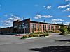
Hillyard is a neighborhood in Spokane, Washington which existed as a separate town between 1892 and 1924.

<span class="mw-page-title-main">Neighborhoods in Spokane, Washington</span>

Neighborhoods in Spokane, Washington are officially grouped by the Spokane City Council into three main city council districts: 1, 2, and 3. Each city council district contains multiple, official neighborhoods that are recognized with a neighborhood council. Informally, neighborhoods are colloquially grouped by local geographical, geological, cultural, or historical features The list of neighborhoods below is organized based on the official designations by the City of Spokane. Unofficial neighborhoods and districts are listed within the official neighborhood in which they are located.

<span class="mw-page-title-main">Downtown Spokane</span> Central business district of Spokane in Washington, United States

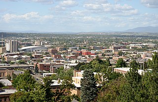
Downtown Spokane or Riverside is the central business district of Spokane, Washington. The Riverside neighborhood is roughly bounded by I-90 to the south, Division Street to the east, Monroe Street to the west and Boone Avenue to the north. The topography of Downtown Spokane is mostly flat except for areas downstream of the Spokane Falls which are located in a canyon; the elevation is approximately 1,900 feet (580 m) above sea level.

Division Street is a major north–south street in Spokane, Washington, United States. It travels approximately 11 miles (18 km) through a majority of the city, albeit non-contiguously through its southern portions, extending from the South Hill to Spokane's northern border and beyond into Spokane County, where it intersects with the North Spokane Corridor.

<span class="mw-page-title-main">Sprague Avenue (Spokane, Washington)</span> Major east–west street serving Spokane

Sprague Avenue is a major east–west street serving Spokane, Spokane Valley, and Liberty Lake, Washington, United States. It travels approximately 17 miles (27 km), extending from Downtown Spokane eastward through Spokane Valley as an arterial road, and continues on as a collector road to its eastern terminus in Liberty Lake.

<span class="mw-page-title-main">Bemiss, Spokane</span> Neighborhood in Spokane, Washington, United States

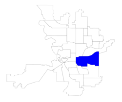
Bemiss is a neighborhood in Spokane, Washington. It is located within City Council District 1, which covers the northeastern section of the city. The neighborhood is bounded by Wellesley Avenue to the north, Market Street to the east, Illinois Avenue and the Spokane River to the south, and Perry Street and Napa Street to the west. It is located to the southeast of the Hillyard neighborhood and is often grouped into greater Hillyard.

<span class="mw-page-title-main">Chief Garry Park, Spokane</span> Neighborhood in Spokane, Washington, United States

Chief Garry Park is a neighborhood in Spokane, Washington. It is located immediately south of the Spokane River. It is named for Spokane Garry and a park that has taken his name. The neighborhood was first established in 1912 but it wasn't until 1932 that it was officially named for Chief Garry.

<span class="mw-page-title-main">Logan, Spokane</span> Spokane Neighborhood in Washington, United States

Logan is a neighborhood in Spokane, Washington. It is located immediately northeast of Downtown Spokane and is home to Gonzaga University. The Spokane River runs along its eastern and southern edge. Due to its proximity to the city center, Logan is home to some of the oldest and densest areas in the city. It is known for its tree-lined streets, historic buildings and population of college students. In addition to numerous individual properties, there are two historic districts listed on the National Register of Historic Places located within Logan: the Desmet Avenue Warehouse Historic District and the Mission Avenue Historic District.

<span class="mw-page-title-main">Minnehaha, Spokane</span> Spokane Neighborhood in Washington, United States

Minnehaha is a neighborhood in Spokane, Washington, located in the northeastern portion of the city. The Spokane River flows along the southern edge of the neighborhood, from which the terrain rises along the slopes of Beacon Hill to the northeast. It is a primarily residential neighborhood, with its main commercial district on Euclid Street shared with the adjacent neighborhoods of Bemiss and Hillyard. Minnehaha Park is located here, though the nearby Minnehaha Rocks are just beyond the neighborhood's bounds.

<span class="mw-page-title-main">Rockwood, Spokane</span> Spokane Neighborhood in Washington, United States

Rockwood is a neighborhood in Spokane, Washington. It is located on the south side of the city to the southeast of Downtown Spokane and expanding southeasterly from close to the city center. Its proximity to downtown makes it one of Spokane's older neighborhoods, with mature trees lining most of its streets. Due to its location on the hill leading up from the Spokane River Valley, the street grid breaks down in many places around Rockwood. The most notable of these is along the winding Rockwood Boulevard, which was designed by the Olmsted Brothers and weaves its way from the northwesternmost corner of the neighborhood through the center and across to the eastern border, highlighting the basalt bluffs and other natural topography.

<span class="mw-page-title-main">Cliff/Cannon, Spokane</span> Neighborhood in Spokane, Washington, United States

Cliff/Cannon is a neighborhood in Spokane, Washington. It is located immediately south of Downtown, Spokane, and on the lower reaches of the broader South Hill. The neighborhood is home to a medical district with Sacred Heart and Deaconess both having their main hospital campuses along Cliff/Cannon's denser northern edge. To the south the neighborhood becomes more residential. City parks break up the residential zoning of the southern half of Cliff/Cannon. It is adjacent to the Cannon Hill area of the neighboring but separate Manito/Cannon Hill neighborhood. The Marycliff-Cliff Park Historic District, a National Historic District listed on the National Register of Historic Places, is located within the neighborhood.

<span class="mw-page-title-main">Latah/Hangman, Spokane</span> Spokane Neighborhood in Washington, United States

Latah/Hangman is a neighborhood in Spokane, Washington.

<span class="mw-page-title-main">Emerson/Garfield, Spokane</span> Spokane Neighborhood in Washington, United States

Emerson/Garfield is a neighborhood in Spokane, Washington. It is located immediately north of Downtown Spokane's North Bank and extends out into the inner northwestern portion of the city. Emerson/Garfield is a diverse neighborhood with residential, commercial and civic zones all bordering one another, with density ranging from single-family homes to multi-use buildings. Due to its location in the central area of Spokane, Emerson/Garfield is criss-crossed by numerous arterials and thoroughfares. Along those main roads are numerous commercial and retail districts of importance to both the neighborhood and city as a whole.

<span class="mw-page-title-main">Lincoln Heights, Spokane</span> Spokane Neighborhood in Washington, United States

Lincoln Heights is a neighborhood in Spokane, Washington. It is located in the southeastern portion of the city in a broader area commonly known as the South Hill. As the name suggests, Lincoln Heights lies on the slopes and atop the crest of the South Hill area. Lincoln Heights is home to a mix of single-family residential, multi-family residential, and commercial areas and a significant amount of park land. The Lincoln Heights Shopping Center and surrounding area is one of the largest and most important commercial and retail districts on the entire south side of Spokane.

<span class="mw-page-title-main">Comstock, Spokane</span> Neighborhood in Washington, United States

Comstock is a neighborhood in Spokane, Washington. It is located on the south side of the city in a broader area commonly known as the South Hill. The neighborhood is primarily single-family residential, and a mix of homes built during the streetcar era and then built during the post-World War II housing boom. The neighborhood is also home to a few commercial districts, including the regionally important Manito Shopping Center, two schools, the eponymous Comstock Park, sports fields and a golf course.

<span class="mw-page-title-main">Southgate, Spokane</span> Spokane Neighborhood in Washington, United States

Southgate is a neighborhood in Spokane, Washington. It is located in the southwestern corner of the City of Spokane and part of the broader area known locally as the South Hill. Southgate is one of the newer neighborhoods in the city, with development first taking hold in the post-World War II housing boom and continuing into the present day. It is a mix of single-family residential, multi-family residential and commercial districts. The neighborhood has grown as Spokane has expanded southward, with multiple annexations expanding Southgate and the city since 2000 and as recently as 2016.

<span class="mw-page-title-main">Grandview/Thorpe, Spokane</span> Spokane Neighborhood in Washington, United States

Grandview/Thorpe is a neighborhood in Spokane, Washington. Located in southwestern Spokane, the neighborhood takes its name from two roads that pass through. Grandview Boulevard, so named because of its location at the top of a ridge from which large swaths of Spokane, the Spokane Valley and surrounding mountains to the north and east such as Mount Spokane, can be seen, is located in the northern part of the neighborhood. Thorpe Road traverses a gully in the central and southern portion of the neighborhood.

<span class="mw-page-title-main">North Hill, Spokane</span> Spokane Neighborhood in Washington, United States

North Hill is a neighborhood in Spokane, Washington. As the name suggests, it is atop a hill on the north side of Spokane, within which it is centrally located and crossed by numerous major thoroughfares. It is home to parks, commercial districts and single family residential areas. The historic Garland Theater is located in North Hill, and the city's main north–south arterial, Division Street, is home to a major commercial district along the eastern edge of the neighborhood.

<span class="mw-page-title-main">West Hills, Spokane</span> Spokane Neighborhood in Washington, United States

West Hills is a neighborhood in Spokane, Washington. As the name suggests, the neighborhood is located on hillsides to the west of downtown Spokane. The neighborhood also extends far to the west along the West Plains to incorporate the Spokane International Airport and surrounding land. As the city has grown over the decades, the West Hills neighborhood has expanded uphill and onto the plains to the west. That history of incremental growth, combined with the hilly topography of the area cut by numerous watercourses, has broken up the neighborhood into multiple, distinct areas with swaths of undeveloped land mixed in between.

<span class="mw-page-title-main">Nevada Heights, Spokane</span> Spokane Neighborhood in Washington, United States

Nevada Heights is a neighborhood in Spokane, Washington, located on the north side of the city. Its southern border is atop a bluff that runs east–west across the north side of the city, which gives the neighborhood its name. Nevada Street, a major north–south arterial, runs through the neighborhood. The neighborhood is largely residential, but also home to large retail districts, medical facilities, schools and parks. Being surrounded by the city of Spokane on all sides, the neighborhood is well integrated into urban area.

References

  1. 1 2 "East Central Neighborhood Snapshot" (PDF). spokanecity.org. City of Spokane. Retrieved 29 October 2021.
  2. "About the Sprague Union District". spragueuniondistrict.com. Retrieved 24 May 2022.
  3. "South Perry District". visitspokane.com. Visit Spokane.
  4. 1 2 Bower, Esther (8 October 2021). "Packed In: 'In the name of the almighty dollar': Homeowners say development's destroying East Central". KXLY. KXLY. Retrieved 29 October 2021.
  5. 1 2 "Map | The University District". spokaneudistrict.org. The University District. Retrieved 29 October 2021.
  6. "East Central Map" (PDF). spokanecity.org. City of Spokane. Retrieved 29 October 2021.
  7. "South Hill". spokaneplanner.com. Spokane Planner. 20 March 2021. Retrieved 29 October 2021.
  8. "South Perry District". visitspokane.com. Visit Spokane Inc. Retrieved 29 October 2021.
  9. "Old Liberty Park". The Spokesman-Review. Retrieved 29 October 2021.
  10. Edelen, Amy (19 May 2021). "University District Gateway Bridge receives state, national awards". The Spokesman-Review. Retrieved 9 November 2021.
  11. Amy, Edelen (18 September 2020). "The Catalyst Building now open in the University District". The Spokesman-Review. Retrieved 9 November 2021.
  12. Oesterheld, Frank. "Neighborhoods Matter: The Impact of the I-90 Freeway on the East Central Neighborhood, an Oral History". spokanehistorical.org. Spokane Historical. Retrieved 9 November 2021.
  13. 1 2 3 4 5 6 Lynn, Adam; Rivers, Robin (February 22, 1998). "Shadow Over Sprague A Once-Proud Spokane Neighborhood Is Threatened By An Epidemic Of Vice And A Serial Killer". The Spokesman-Review. Retrieved October 26, 2023.
  14. "EAST CENTRAL ARCHITECTURAL SURVEY AND INVENTORY". spokanehistoric.org. City - County of Spokane Historic Preservation Office. Retrieved 9 November 2021.
  15. 1 2 "Rekindling East Sprague Avenue". Spokane Journal of Business. 15 December 2016. Retrieved 9 November 2021.
  16. Scott, Chey (10 May 2012). "Eclectic renewal shapes Spokane's South Perry District". Spokane Journal of Business. Retrieved 9 November 2021.
  17. "Perry Street Thursday Market". Perry Street Thursday Market. Retrieved 9 November 2021.
  18. "South Perry Street Fair". South Perry Business and Neighborhood Association. Retrieved 9 November 2021.
  19. Deshais, Nicholas (24 July 2013). "Ben Stuckart floats plan for targeted renewal". The Spokesman-Review. Retrieved 9 November 2021.
  20. Criscione, Wilson (May 19, 2017). "East Sprague neighborhood rebrands as 'Sprague Union District'". Inlander . Retrieved October 28, 2023.
  21. Shanks, Adam (7 November 2021). "After yearslong construction project, East Sprague Avenue reopens". The Spokesman-Review. Retrieved 9 November 2021.
  22. Edelen, Amy (27 December 2020). "The Dirt: McKinley School developers make changes to their plan". The Spokesman-Review. Retrieved 9 November 2021.
  23. Numbers represent an alphabetical ordering by significant words. Various colorings, defined here, differentiate National Historic Landmarks and historic districts from other NRHP buildings, structures, sites or objects.
  24. The eight-digit number below each date is the number assigned to each location in the National Register Information System database, which can be viewed by clicking the number.
  25. Blocker, Kevin (9 September 2019). "Gonzaga, UW plan new $60 million health education building". Spokane Journal of Business. Retrieved 23 June 2022.
  26. 1 2 3 "High School Boundary Map" (PDF). spokaneschools.org. Spokane Public Schools. Retrieved 14 June 2022.
  27. 1 2 3 "Elementary School Boundary Map" (PDF). spokaneschools.org. Spokane Public Schools. Retrieved 14 June 2022.
  28. "About Us". spokaneschools.org. Spokane Public Schools. Retrieved 23 June 2022.
  29. 1 2 3 4 "Spokane NW Quadrangle". usgs.gov. U.S. Geological Survey. Archived from the original on 3 May 2022. Retrieved 23 June 2022.
  30. 1 2 "Official Arterial Street Map" (PDF). spokanecity.org. City of Spokane. Retrieved 6 May 2022.
  31. "Spokane Regional Bike Map". arcgis.org. City of Spokane, Spokane County. Retrieved 6 May 2022.
  32. Deshais, Nicholas (January 8, 2019). "Getting There: The curious case of Benjamin Burr". The Spokesman Review. Retrieved 6 May 2022.
  33. "STA System Map" (PDF). spokanetransit.com. Spokane Transit Authority. Retrieved 18 June 2022.