Lincoln Heights, Spokane

Last updated
Lincoln Heights
Lincoln Heights Retirement Community.png
Retirement community towers in Lincoln Heights
Lincoln Heightscropped.png
Location within the city of Spokane
Coordinates: 47°38′12.0″N117°22′05.4″W / 47.636667°N 117.368167°W / 47.636667; -117.368167
CountryUnited States
StateWashington
County Spokane
CitySpokane
Population
 (2017 [1] )
  Total14,272
Demographics 2017
   White 86.4%
  Latinx5.8%
  Asian/Native Hawaiian/Pacific Islander3.3%
  Black3.0%
  American Indian1.2%
Time zone UTC-8 (PST)
  Summer (DST) UTC-7 (PDT)
ZIP Codes
99202, 99203 and 99223
Area code 509

Lincoln Heights is a neighborhood in Spokane, Washington. It is located in the southeastern portion of the city in a broader area commonly known as the South Hill. As the name suggests, Lincoln Heights lies on the slopes and atop the crest of the South Hill area. Lincoln Heights is home to a mix of single-family residential, multi-family residential, and commercial areas and a significant amount of park land. The Lincoln Heights Shopping Center and surrounding area is one of the largest and most important commercial and retail districts on the entire south side of Spokane.

Contents

History

What is now Lincoln Heights was inhabited by the Spokane people for centuries.

In 1885, what is now Lincoln Heights was connected with the then burgeoning city of Spokane via a county road laid along the route of 29th Avenue. As the region recovered from the Great Spokane Fire of 1889 and Panic of 1893, Lincoln Heights saw rapid development. Streetcars arrived in the mid-1890s, with a line extending along 29th Avenue east to Myrtle Street and lines terminating in the northern, lower portion of the neighborhood at 12th Avenue and Altamont Boulevard and another at 17th Avenue and Ray Street. These lines were laid in part to help sell home sites in the neighborhood. [2]

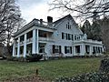
As part of their plan for the layout of the city in 1908, the Olmsted Brothers recommended establishing a large park in the north of the neighborhood. In 1912, the Hutton family, philanthropists and landowners in the neighborhood, donated 31 acres of land that became Lincoln Park. The Huttons would build their colonial revival mansion residence next to the park in 1914, at a cost of $45,000 ($1,300,990.50 in 2022 dollars). [3] [4]

Franklin Elementary School Franklin Elementary School NRHP 100000946 Spokane County,WA.jpg
Franklin Elementary School

Charles Francis Adams Jr., a wealthy landowner from Boston and member of the politically powerful Adams family, sold his family's 900-acre plot of land on the eastern edge of Lincoln Heights, which opened it up for development. On the neighborhood's northern edge, Adams Elementary School was named for him. After an initial surge in purchases in the Lincoln Heights Addition, construction slowed, and the neighborhood retained a mixed rural and urban character through the early decades of the 20th century. [2]

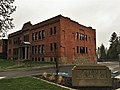
Franklin Elementary, located at 17th Avenue and Mt. Vernon Road, a few blocks down the road from the Hutton home, was built in 1909. Though the school has been remodeled and expanded in the century since, the original building remains. [5]

In the 1950s, the neighborhood took on its importance as a commercial center for the south side of the city when the Lincoln Heights Shopping Center was constructed at 29th Avenue and Regal Street. It would be expanded further in the 1970s and has been surrounded by other commercial zones in the years since. [2]

The neighborhood's dual rural and urban character in the first half of the 20th century faded away as infill developments took place in the 1970s and 1980s. In the southern and eastern portions of Lincoln Heights, the farthest from the city center, this has resulted in craftsman homes from the early 20th century next to late 20th century split-level and ranch-style homes. [6]

Historic places

Lincoln Heights is home to five properties listed on the National Register of Historic Places. All five are located in the older, lower part of the neighborhood which is closer to the city center than the higher, newer areas of Lincoln Heights to the south and east.

[7] Name on the RegisterImageDate listed [8] LocationDescription
1 Gus and Florence Ehrenberg House
Gus and Florence Ehrenberg House Ehrenberg House NRHP 07000832 Spokane County, WA.jpg
Gus and Florence Ehrenberg House
August 16, 2007
(#07000832)
1304 S. Cook St.
47°38′43″N117°22′25″W / 47.6453°N 117.3736°W / 47.6453; -117.3736 (Gus and Florence Ehrenberg House)
Built in 1911.
2 Franklin Elementary School
Franklin Elementary School Franklin Elementary School NRHP 100000946 Spokane County,WA.jpg
Franklin Elementary School
May 1, 2017
(#100000946)
2627 E. 17th Ave.
47°38′26″N117°22′17″W / 47.640535°N 117.371277°W / 47.640535; -117.371277 (Franklin Elementary School)
3 Levi and May Arkwright Hutton House
Levi and May Arkwright Hutton House Hutton House NRHP 02000088 Spokane County, WA.jpg
Levi and May Arkwright Hutton House
February 21, 2002
(#02000088)
2206 W. 17th Ave.
47°38′24″N117°22′40″W / 47.64°N 117.377778°W / 47.64; -117.377778 (Levi and May Arkwright Hutton House)
Built in 1914, this was the home of May Arkwright.
4 Koerner House
Koerner House Koerner House NRHP 99000915 Spokane County, WA.jpg
Koerner House
July 28, 1999
(#99000915)
1824 S. Mount Vernon St.
47°38′20″N117°22′11″W / 47.638889°N 117.369722°W / 47.638889; -117.369722 (Koerner House)
Built in 1912.
5 Ralston and Sarah Wilbur House
Ralston and Sarah Wilbur House Wilbur House NRHP 06000136 Spokane County, WA.jpg
Ralston and Sarah Wilbur House
March 15, 2006
(#06000136)
2525 E. 19th Ave.
47°38′26″N117°22′18″W / 47.640556°N 117.371667°W / 47.640556; -117.371667 (Ralston and Sarah Wilbur House)
Built in 1916.

Geography

As the name suggests, Lincoln Heights is located on the slopes and crest of Spokane's South Hill area, the local name for the broader southern side of the city. The slopes rise from the Spokane Valley below to the elevation of the Columbia Plateau. In places, like in Lincoln Park, the slope is so steep that it exists as vertical faces of exposed Columbia River Basalt Group rock cliffs. [9] The neighborhood rises from approximately 2,000 feet in the north to 2,300 feet in the south. [10] [11]

Havana Street serves as the eastern boundary of Lincoln Heights and the City of Spokane. The unincorporated Glenrose neighborhood lies to the east. 37th Avenue is the northern border, stretching west from Havana Street to Perry Street. The western side of Lincoln Heights is interrupted by the Rockwood neighborhood, appearing on a map as if a bite has been taken out of it. The western border runs along Perry Street from 37th to 29th Avenues, where it cuts east along 29th for more than half a mile. At 29th Avenue and Southeast Boulevard, the border follows Southeast around the curving eastern edge of Rockwood to 14th Avenue. At 14th, the northern border runs east from Southeast Boulevard to Crestline Street, cutting north for six blocks. From Crestline to Havana, the northern border mostly follows a ridge along which the Ben Burr Trail is located. [2]

Lincoln Park LincolnParkSpokane (20100219980).jpg
Lincoln Park

As with the rest of the city of Spokane, parkland is an important feature of Lincoln Heights. Lincoln Park spans the upper and lower portions of the neighborhood and takes up 51 acres. Thornton Murphy Park, adjacent to the Lincoln Heights Shopping Center, is 8 acres large. Froggy Pond is a five-acre space at 30th Avenue and Havana Street in the southeastern section of the neighborhood. Along the northern edge of Lincoln Heights runs the Ben Burr Trail connecting Liberty and Underhill Parks in neighboring East Central. A grassy and tree-lined parkway runs down the middle of 35th Avenue from Regal Street in the center of the neighborhood to the city limits on the east. There are also outdoor recreation opportunities at the three public elementary school campuses and one public middle school campus in Lincoln/Heights. [2]

Most of the neighborhood, especially the eastern and southern portions, conform to the city's street grid. However, along the ridge that runs through the middle of the neighborhood, and on the rocky slopes along the north, streets are forced to wind their way through the local terrain. There are many loops and dead-ends in this area. [2]

Education

Lincoln Heights is home to six schools, two private and four public. Franklin Elementary, located at 17th Avenue and Mt. Vernon Road, serves the northern and central portions of the neighborhood. Lincoln Heights Elementary, at 23rd Avenue and Ray Street, serves the eastern areas of Lincoln Heights. At 37th Avenue and Regal Street, Adams Elementary serves the southeastern portion of the neighborhood. The southwestern portion is part of the Hamblen Elementary district, located in the neighboring Southgate neighborhood. A few square blocks in the far northwest corner of the neighborhood are part of the Grant Elementary district, located in neighboring East Central. [12]

Franklin and Lincoln Heights feed into Chase Middle School, located in the far southeastern corner of the neighborhood at 37th Avenue. Adams and Hamblen previously did as well, but are set to move into the district of a new middle school under construction to the south. [12] All of Lincoln Heights, except the small portion which is part of the Grant Elementary and Sacajawea Middle School districts feeds into Joel E. Ferris High School, which is located across the street from Adams Elementary at 37th Avenue and Regal Street. The Grant/Sacajawea portion of Lincoln Heights is served by Lewis and Clark High School. [13]

Private schools in Lincoln Heights are All Saints Primary at 18th Avenue and Freya and All Saints Middle at 33rd Avenue and Perry Street. [2]

Transportation

Surface Streets

29th Avenue passes through the heart of Lincoln Heights as it traverses the entire South Hill from east to west. It is the only east-west street on the South Hill designated as a principal arterial by the city, and it is a major transportation corridor in both the neighborhood and wider South Hill. Ray Street, running north-south through the eastern half of Lincoln Heights, is designated as a principal arterial as well. Those two, along with Regal Street, a minor arterial, are the only four-lane roads in the neighborhood. [14]

Along with Regal Street, Southeast Boulevard and Freya Street are classified as minor arterials. 17th and 27th Avenues are classified as collectors. At the same time, the rest of the streets in Lincoln Heights are local-access roads. [14]

For cyclists, a dedicated bicycle lane exists along the length of Southeast Boulevard through Lincoln Heights and along 37th Avenue east of Regal Street. Bike routes noted by signage along roadways follow 17th Avenue, 29th Avenue, 37th Avenue west of Regal Street, and Freya Street. A signed bike lane also follows Altamont Boulevard and 11th Avenue in the north of the neighborhood, connecting to the rest of the bike network via Fiske Street. [15] That segment connects with the Ben Burr Trail, which connect with a broader network of non-motorized trails throughout the Spokane area including the vast Spokane River Centennial Trail. [16]

Public Transit

Lincoln Heights, like the rest of the Spokane metropolitan area, has its public transit provided by the Spokane Transit Authority. The STA serves Lincoln Heights with five fixed-route bus lines. The South Hill Park and Ride is located on East 31st.

[17]

RouteTerminiService operation and notesStreets traveled
4
Moran Prairie
Downtown Spokane
STA Plaza
Glenrose
Moran Station Park & Ride
High-frequency routeRegal
34
Freya
Chief Garry Park
Spokane Community College
Lincoln Heights
South Hill Park & Ride
Basic-frequency routeRay, 18th, Freya, 29th, South Hill Park & Ride
43
Lincoln/37th
Downtown Spokane
STA Plaza
Lincoln Heights
South Hill Park & Ride
Basic-frequency route37th, Ray, 29th, South Hill Park & Ride
45
Perry District
Downtown Spokane
STA Plaza
Lincoln Heights
South Hill Park & Ride
Basic-frequency routeSoutheast Boulevard, South Hill Park & Ride

Demographics

As of 2017, Lincoln Heights was home to 14,272 people across 6,364 households. Renters made up 41.3% of those households, below the citywide average of 45.3%. The median household income was $53,572, above the citywide median of $44,768. 53.9% of students qualified for free or reduced lunch, compared to 54.5% for the city. People over age 65 made up 18.2% of residents, while those aged 19 or younger made up 23.8% of residents. 25.8% of households had children.

People born in the United States or its territories made up 91.5% of residents. Of the residents born outside of the United States, 15.4% came from Ukraine, 14.5% from Russia, 13.8% from Moldova and 7.3% from Vietnam. [1]

Related Research Articles

<span class="mw-page-title-main">Town and Country, Washington</span> CDP in Washington, United States

Town and Country is a census-designated place (CDP) in Spokane County, Washington, United States. The population was 5,068 at the 2020 census.

<span class="mw-page-title-main">Hillyard, Spokane</span> Neighborhood of Spokane in Spokane County, Washington, United States

Hillyard is a neighborhood in Spokane, Washington which existed as a separate town between 1892 and 1924.

<span class="mw-page-title-main">Neighborhoods in Spokane, Washington</span>

Neighborhoods in Spokane, Washington are officially grouped by the Spokane City Council into three main city council districts: 1, 2, and 3. Each city council district contains multiple, official neighborhoods that are recognized with a neighborhood council. Informally, neighborhoods are colloquially grouped by local geographical, geological, cultural, or historical features The list of neighborhoods below is organized based on the official designations by the City of Spokane. Unofficial neighborhoods and districts are listed within the official neighborhood in which they are located.

<span class="mw-page-title-main">Bemiss, Spokane</span> Neighborhood in Spokane, Washington, United States

Bemiss is a neighborhood in Spokane, Washington. It is located within City Council District 1, which covers the northeastern section of the city. The neighborhood is bounded by Wellesley Avenue to the north, Market Street to the east, Illinois Avenue and the Spokane River to the south, and Perry Street and Napa Street to the west. It is located to the southeast of the Hillyard neighborhood and is often grouped into greater Hillyard.

<span class="mw-page-title-main">Chief Garry Park, Spokane</span> Neighborhood in Spokane, Washington, United States

Chief Garry Park is a neighborhood in Spokane, Washington. It is located immediately south of the Spokane River. It is named for Spokane Garry and a park that has taken his name. The neighborhood was first established in 1912 but it wasn't until 1932 that it was officially named for Chief Garry.

<span class="mw-page-title-main">Logan, Spokane</span> Spokane Neighborhood in Washington, United States

Logan is a neighborhood in Spokane, Washington. It is located immediately northeast of Downtown Spokane and is home to Gonzaga University. The Spokane River runs along its eastern and southern edge. Due to its proximity to the city center, Logan is home to some of the oldest and densest areas in the city. It is known for its tree-lined streets, historic buildings and population of college students. In addition to numerous individual properties, there are two historic districts listed on the National Register of Historic Places located within Logan: the Desmet Avenue Warehouse Historic District and the Mission Avenue Historic District.

<span class="mw-page-title-main">East Central, Spokane</span> Spokane Neighborhood in Washington, United States

East Central is a neighborhood in Spokane, Washington. As the name suggests, it is on the east side of Spokane and centrally located. The official neighborhood is expansive and covers multiple areas considered by locals to be independent neighborhoods, such as the Sprague Union District on East Sprague Avenue, the South Perry District, the Underhill Park area and the University District on the eastern fringe of Downtown Spokane.

<span class="mw-page-title-main">Minnehaha, Spokane</span> Spokane Neighborhood in Washington, United States

Minnehaha is a neighborhood in Spokane, Washington, located in the northeastern portion of the city. The Spokane River flows along the southern edge of the neighborhood, from which the terrain rises along the slopes of Beacon Hill to the northeast. It is a primarily residential neighborhood, with its main commercial district on Euclid Street shared with the adjacent neighborhoods of Bemiss and Hillyard. Minnehaha Park is located here, though the nearby Minnehaha Rocks are just beyond the neighborhood's bounds.

<span class="mw-page-title-main">Rockwood, Spokane</span> Spokane Neighborhood in Washington, United States

Rockwood is a neighborhood in Spokane, Washington. It is located on the south side of the city to the southeast of Downtown Spokane and expanding southeasterly from close to the city center. Its proximity to downtown makes it one of Spokane's older neighborhoods, with mature trees lining most of its streets. Due to its location on the hill leading up from the Spokane River Valley, the street grid breaks down in many places around Rockwood. The most notable of these is along the winding Rockwood Boulevard, which was designed by the Olmsted Brothers and weaves its way from the northwesternmost corner of the neighborhood through the center and across to the eastern border, highlighting the basalt bluffs and other natural topography.

<span class="mw-page-title-main">Manito/Cannon Hill, Spokane</span> Neighborhood in Spokane, Washington, United States

Manito/Cannon Hill is a neighborhood on the South Hill of Spokane, Washington. It is named after the two public parks that dominate its setting: Manito Park and Cannon Hill Park. Manito/Cannon Hill is a predominantly residential neighborhood made up mostly by single-family homes and city park land.

<span class="mw-page-title-main">Latah/Hangman, Spokane</span> Spokane Neighborhood in Washington, United States

Latah/Hangman is a neighborhood in Spokane, Washington.

<span class="mw-page-title-main">Emerson/Garfield, Spokane</span> Spokane Neighborhood in Washington, United States

Emerson/Garfield is a neighborhood in Spokane, Washington. It is located immediately north of Downtown Spokane's North Bank and extends out into the inner northwestern portion of the city. Emerson/Garfield is a diverse neighborhood with residential, commercial and civic zones all bordering one another, with density ranging from single-family homes to multi-use buildings. Due to its location in the central area of Spokane, Emerson/Garfield is criss-crossed by numerous arterials and thoroughfares. Along those main roads are numerous commercial and retail districts of importance to both the neighborhood and city as a whole.

<span class="mw-page-title-main">Comstock, Spokane</span> Neighborhood in Washington, United States

Comstock is a neighborhood in Spokane, Washington. It is located on the south side of the city in a broader area commonly known as the South Hill. The neighborhood is primarily single-family residential, and a mix of homes built during the streetcar era and then built during the post-World War II housing boom. The neighborhood is also home to a few commercial districts, including the regionally important Manito Shopping Center, two schools, the eponymous Comstock Park, sports fields and a golf course.

<span class="mw-page-title-main">Southgate, Spokane</span> Spokane Neighborhood in Washington, United States

Southgate is a neighborhood in Spokane, Washington. It is located in the southwestern corner of the City of Spokane and part of the broader area known locally as the South Hill. Southgate is one of the newer neighborhoods in the city, with development first taking hold in the post-World War II housing boom and continuing into the present day. It is a mix of single-family residential, multi-family residential and commercial districts. The neighborhood has grown as Spokane has expanded southward, with multiple annexations expanding Southgate and the city since 2000 and as recently as 2016.

<span class="mw-page-title-main">North Hill, Spokane</span> Spokane Neighborhood in Washington, United States

North Hill is a neighborhood in Spokane, Washington. As the name suggests, it is atop a hill on the north side of Spokane, within which it is centrally located and crossed by numerous major thoroughfares. It is home to parks, commercial districts and single family residential areas. The historic Garland Theater is located in North Hill, and the city's main north–south arterial, Division Street, is home to a major commercial district along the eastern edge of the neighborhood.

<span class="mw-page-title-main">Audubon/Downriver, Spokane</span> Spokane Neighborhood in Washington, United States

Audubon/Downriver is a neighborhood in Spokane, Washington, located on the northwest side of the city. There is a diversity of land use in the neighborhood, with single-family residential areas dating from the early 20th century through the Post–World War II economic expansion era, regionally important commercial districts, smaller neighborhood retail areas, numerous schools, large parks, a golf course, conservation areas and part of Riverside State Park along the Spokane River. The neighborhood is the site of the corporate offices for Rosauers Supermarkets, a regional grocery store chain with stores located across the Northwestern United States.

<span class="mw-page-title-main">Nevada Heights, Spokane</span> Spokane Neighborhood in Washington, United States

Nevada Heights is a neighborhood in Spokane, Washington, located on the north side of the city. Its southern border is atop a bluff that runs east–west across the north side of the city, which gives the neighborhood its name. Nevada Street, a major north–south arterial, runs through the neighborhood. The neighborhood is largely residential, but also home to large retail districts, medical facilities, schools and parks. Being surrounded by the city of Spokane on all sides, the neighborhood is well integrated into urban area.

<span class="mw-page-title-main">Shiloh Hills, Spokane</span> Spokane Neighborhood in Washington, United States

Shiloh Hills is a neighborhood in Spokane, Washington, located on the far northeastern side of the city. It is one of the newer areas of the city, initially annexed in the late 1960s with growth continuing into the 21st century. The neighborhood is home to residential, commercial and industrial districts as well as multiple regionally important transportation corridors such as the Division Street "Y".

<span class="mw-page-title-main">Northwest, Spokane</span> Spokane Neighborhood in Washington, United States

Northwest is a neighborhood in Spokane, Washington, located in the northwestern portion of the city. Largely single-family residential, Northwest is also home to Spokane's VA Medical Center, the Dwight Merkel Sports complex, a large public sports facility, and portions of Riverside State Park along the Spokane River. The neighborhood contains developments that span from the post-World War II housing boom in the east to more contemporary, suburban-style developments in the west. It was also home to Joe Albi Stadium from 1950 until 2022, which served as the Spokane region's main high school sports stadium over its seven decades of use.

<span class="mw-page-title-main">Whitman, Spokane</span> Spokane Neighborhood in Washington, United States

Whitman is a neighborhood located on the northeast side of Spokane, Washington. It is named for pioneer missionaries Marcus and Narcissa Whitman.

References

  1. 1 2 "Lincoln Heights Neighborhood Snapshot" (PDF). spokanecity.org. City of Spokane. Retrieved 21 May 2022.
  2. 1 2 3 4 5 6 7 "Lincoln Heights Neighborhood Profile" (PDF). spokanecity.org. City of Spokane. Retrieved 22 May 2022.
  3. "CPI Inflation Calendar". data.bls.gov. U.S. Bureau of Labor Statistics. Retrieved 22 May 2022.
  4. Harbine, Anna. "Hutton Home". spokanehistorical.org. Eastern Washington University. Retrieved 22 May 2022.
  5. Culver, Nina (11 January 2019). "Historic Franklin Elementary renovation complete". The Spokaesman-Review. Retrieved 23 May 2022.
  6. "Lincoln Heights Neighborhood District Center Plan" (PDF). spokanecity.org. City of Spokane. 2016. p. 2.1. Retrieved 23 May 2022.
  7. Numbers represent an alphabetical ordering by significant words. Various colorings, defined here, differentiate National Historic Landmarks and historic districts from other NRHP buildings, structures, sites or objects.
  8. The eight-digit number below each date is the number assigned to each location in the National Register Information System database, which can be viewed by clicking the number.
  9. "Olmsted Legacy Heritage Tour". historicspokane.org. City - County of Spokane Historic Preservation Office. Retrieved 23 May 2022.
  10. "Spokane NE Quadrangle" (map). usgs.gov. U.S. Geological Survey. 2020. Retrieved 23 May 2022.
  11. "Spokane NW Quadrangle" (Map). usgs.gov. U.S. Geological Survey. 2020. Retrieved 23 May 2022.
  12. 1 2 "Elementary School Boundary Map" (Map). spokaneschools.org. Spokane Public Schools. 30 June 2021. Retrieved 23 May 2022.
  13. "High School Boundary Map" (Map). spokaneschools.org. 30 June 2021: Spokane Public Schools. Retrieved 23 May 2022.{{cite web}}: CS1 maint: location (link)
  14. 1 2 "Official Arterial Street Map" (Map). spokanecity.org. City of Spokane. October 2019. Retrieved 23 May 2022.
  15. "Spokane Regional Bike Map". srtc.maps.arcgis.com. Spokane Regional Transportation Council. Retrieved 23 May 2022.
  16. Deshais, Nicholas (January 8, 2019). "Getting There: The curious case of Benjamin Burr". The Spokesman Review. Retrieved 22 May 2022.
  17. "STA System Map" (PDF). spokanetransit.com. Spokane Transit Authority. Retrieved 19 June 2022.