Grange, Merseyside

Last updated

Grange
The Black Horse Inn, West Kirby - geograph.org.uk - 216664.jpg
The Black Horse Inn, Black Horse Hill, in 2006
Merseyside UK location map.svg
Red pog.svg
Grange
Location within Merseyside
OS grid reference SJ227867
  London 182 mi (293 km) [1]   SE
Metropolitan borough
Metropolitan county
Region
Country England
Sovereign state United Kingdom
Post town WIRRAL
Postcode district CH48
Dialling code 0151
ISO 3166  codeGB-WRL
Police Merseyside
Fire Merseyside
Ambulance North West
UK Parliament
List of places
UK
England
Merseyside
53°22′12″N3°10′05″W / 53.370°N 3.168°W / 53.370; -3.168 Coordinates: 53°22′12″N3°10′05″W / 53.370°N 3.168°W / 53.370; -3.168

Grange (historically known as Caldy Grange, which gives its name to the local grammar school) is a suburb of West Kirby, on the Wirral Peninsula, in the Metropolitan Borough of Wirral, Merseyside, England. The suburb is contiguous with Newton to the north east. Historically part of the county of Cheshire, it is within the local government ward of West Kirby and Thurstaston and the parliamentary constituency of Wirral West.

Contents

History

According to the Domesday Book of 1086, Grange (also called Great Caldy, or Caldy Grange) was one of the estates owned by Hugh Delamere, consisting of a single household. [2] The land later passed into the hands of Basingwerk Abbey, until the dissolution of the Monasteries. In the seventeenth century it became the property of William Glegg who also founded Calday Grange Grammar School, and it remained the property of the Gleggs until 1785, when it was bought by John Leigh, a Liverpool solicitor and property speculator, who refounded the grammar school. He passed it on to his son John Shaw Leigh who later went on to buy Luton Hoo. By the twentieth century the area was in the hands of the trustees of Madame de Falbe, his son John Gerard Leigh's widow, who had remarried to Christian de Falbe, the Danish ambassador.

Grange was a township in West Kirby parish of the Wirral Hundred, which became a civil parish in 1866 and included the hamlets of Caldy Grange and Newton Carr. The civil parish was part of Wirral Rural District, then from 1933 Hoylake Urban District, within the county of Cheshire. From 1 April 1974 it became an unparished area in Merseyside. [3] [4] The population was recorded at 10 in 1801, 105 in 1851, 299 in 1901 and rising to 7,657 by 1951. [3]

Geography

Grange is in the north-western part of the Wirral Peninsula, approximately 2.5 km (1.6 mi) south-east of the Irish Sea at Hoylake, less than 2 km (1.2 mi) east of the Dee Estuary at West Kirby and 10 km (6.2 mi) west-south-west of the River Mersey at Seacombe. Grange is situated on the eastern side of the ridge which includes Grange Hill, with the area at an elevation of between 13–54 m (43–177 ft) above sea level. [5]

Education

In 1636 local landowner William Glegg founded Calday Grange Grammar School on the present site on Grammar School Lane, off Column Road. It was established as a free grammar school and is Wirral's oldest surviving grammar school. Glegg's vision was that the school should have ‘continuance and endure for evermore'. Over the years, his little 12 pupil school has been enlarged into an establishment of nearly 1,400 students – which includes over 400 male and female students in the Sixth Form. [6]

The locality is also served by Hilbre High School and West Kirby Grammar School at secondary education level.

Sport

Shooting

Grange Rifle and Pistol Club is a private members club which was established in 1942. [7] and offers many types of shooting including air rifle/pistol, black powder pistol, gallery rifle, smallbore rifle, long barreled revolver, fullbore rifle and archery.

Swimming

Near the grammar school on Gourley's Lane is Calday Grange Swimming Pool which is home to Calday Grange Amateur Swimming Club, West Kirby Amateur Swimming Club, Hoylake Amateur Swimming Club, Woodchurch Swimming Club and the Peninsula Canoe Club.

Transport

Road

The B5139 passes around and through Grange to the north. The B5139 has junctions with the B5192 Saughall Massie Road and the A540 Column Road, the latter of which runs along the western side of Grange.

Rail

West Kirby railway station is the nearest to Grange, less than 1 km (0.62 mi) to the west. This station is on the Wirral line of the Merseyrail network, with frequent services to Liverpool.

See also

Related Research Articles

Hoylake Seaside town and home of the Royal Liverpool golf club, in Wirral, England

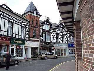
Hoylake is a seaside town in the Metropolitan Borough of Wirral, Merseyside, England. It is at the north west of the Wirral Peninsula, near West Kirby and where the River Dee meets the Irish Sea. Historically part of Cheshire, the Domesday Book recorded it within the Hundred of Wilaveston.

West Kirby Coastal town on the estuary of the River Dee, Wirral, England

West Kirby is a town on the north-west corner of the Wirral Peninsula in Merseyside, England, at the mouth of the River Dee. Within the boundaries of the historic county of Cheshire, to the north-east lies Hoylake, to the east Grange and Newton, and to the south-east Caldy. At the 2011 Census, the population was 12,733. The town is on the opposite side of the River Dee to Mostyn in North Wales.

Irby, Merseyside Town in Wirral, England

Irby is a village on the Wirral Peninsula, in Merseyside, England. The village covers an area of 20 square kilometres. To the north of Irby lies the associated hamlet of Irby Hill. It is part of the Greasby, Frankby and Irby Ward of the Metropolitan Borough of Wirral and is within the parliamentary constituency of Wirral West.

Wirral Peninsula Peninsula in North West England

Wirral, also known as The Wirral, is a peninsula in North West England. The roughly rectangular peninsula is about 15 miles (24 km) long and 7 miles (11 km) wide and is bounded by the River Dee to the west that forms a boundary with Wales, the River Mersey to the east, and the Irish Sea to the north.

Caldy Hill

Caldy Hill is an area of heath and woodland on a sandstone outcrop on the Wirral Peninsula. The land was bought by Hoylake District Council between 1897 and 1974. The village of Caldy is nearby.

Caldy Village in the Wirral, England

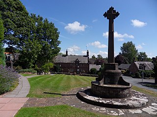
Caldy is a small, affluent village on the Wirral Peninsula, England, south-east of West Kirby. It is part of the West Kirby & Thurstaston Ward of the Metropolitan Borough of Wirral and is in the parliamentary constituency of Wirral West. At the time of the 2001 Census, Caldy had 1,290 inhabitants, of a total ward population of 12,869.

Greasby Town in Wirral, England

Greasby is a large village on the Wirral Peninsula, Merseyside, England. A predominantly residential area, it is contiguous with Upton to the east and Saughall Massie to the north. The small village of Frankby is to the immediate west. Historically within the county of Cheshire, it is part of the Greasby, Frankby and Irby Ward of the Metropolitan Borough of Wirral and is in the parliamentary constituency of Wirral West.

Thurstaston Village on the Wirral Peninsula, Merseyside, England

Thurstaston is a village on the Wirral Peninsula, Merseyside, England. It is part of the West Kirby and Thurstaston Ward of the Metropolitan Borough of Wirral and the parliamentary constituency of Wirral West. The village lies on the A540 road between Heswall and Caldy, although it extends some distance down Station Road to the Wirral Way and the River Dee estuary.

Saughall Massie Village on the Wirral Peninsula, Merseyside, England

Saughall Massie is a village on the Wirral Peninsula, Merseyside, England. It is part of the Moreton West & Saughall Massie Ward of the Metropolitan Borough of Wirral and the parliamentary constituency of Wallasey. A small village primarily made up of large fields owned by local farmers, it is bordered by Greasby, Meols, Moreton and Upton. At the 2001 census Saughall Massie had a population of 1,260.

Noctorum Human settlement in England

Noctorum is a suburb of Birkenhead, Merseyside, England. Administratively it is within the Metropolitan Borough of Wirral as part of Claughton Ward. Noctorum is in the north east of the Wirral Peninsula, bounded by the Beechwood estate to the north, Claughton and Oxton to the east and south east, and the River Fender and M53 motorway to the west.

Frankby Village in Wirral, England

Frankby is a village on the Wirral Peninsula, in Merseyside, England. It is located between Greasby and Newton on the outskirts of the town of West Kirby. The hamlet of Larton is to the north west. Historically within the county of Cheshire, it is part of the Greasby, Frankby and Irby Ward of the Metropolitan Borough of Wirral and is in the parliamentary constituency of Wirral West.

Newton, Merseyside Village in Wirral, Merseyside, England

Newton is a village on the Wirral Peninsula, in the Metropolitan Borough of Wirral, Merseyside, England. It is a part of the suburban town of West Kirby, the local government ward of West Kirby and Thurstaston and the parliamentary constituency of Wirral West. Contiguous with Newton is the suburb of Grange to the west. The hamlet of Larton is to the east.

Larton Hamlet in Wirral, England

Larton is a hamlet near the town of West Kirby, on the Wirral Peninsula, in Merseyside, England. Administratively it is part of the local government ward of Greasby, Frankby and Irby in the Metropolitan Borough of Wirral and is within the parliamentary constituency of Wirral West.

William Glegg was the founder of the Calday Grange Grammar School. A man of considerable local standing, he founded the school in 1636. He gave 15 acres (61,000 m2) of land to provide an annual income of £12 per year for a schoolmaster. In the declaration he made when founding the school he wrote:

Church of the Resurrection and All Saints, Caldy Church in Merseyside, England

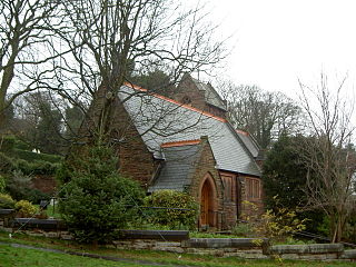
The Church of the Resurrection and All Saints is in the village of Caldy, Wirral, Merseyside, England. The church is recorded in the National Heritage List for England as a designated Grade II listed building. It is an active Anglican church in the diocese of Chester, the archdeaconry of Chester and the deanery of Wirral North. It is a daughter church of St Bridget's Church, West Kirby.

Wirral Grammar School for Girls is an all-girls grammar school on the Wirral Peninsula in Merseyside, England.

Calday Grange Grammar School Grammar, academy in West Kirby, Wirral, England

Calday Grange Grammar School is a non-denominational selective state grammar school, founded in 1636, situated on Caldy Hill in Grange, a suberb of West Kirby on the Wirral peninsula, England. The school admits boys from age 11 to 18 and, since 1985, girls for the sixth form only. The school has academy status, hosts the Wirral Able Children Centre, and has been awarded Sportsmark Gold and Investors in People status.

Hoylake Urban District

Hoylake Urban District was an urban district in Cheshire, England. It was formerly known as West Kirby and Hoylake Urban District (1894–97), then Hoylake and West Kirby Urban District (1897–1933). It was the local authority for the towns of Hoylake and West Kirby, in the north-west of the Wirral Peninsula.

Jack Lavin is an English rugby union player who is currently at Esher in National League 1 having signed from Caldy for the 2017–18 season. He plays at Fly-half or Inside Centre and is an excellent points kicker who can also score tries. As well as playing club rugby he has represented Cheshire in the county championships, finishing as runners up in 2016, as well as being capped by England Counties XV.

References

  1. "Coordinate Distance Calculator". boulter.com. Retrieved 6 March 2016.
  2. Powell-Smith, Anna. "[Great] Caldy". Open Domesday/University of Hull. Retrieved 7 March 2021.
  3. 1 2 "Grange". GENUKI UK & Ireland Genealogy. Retrieved 7 March 2021.
  4. "Grange Tn/CP". A Vision of Britain through Time. GB Historical GIS / University of Portsmouth. Retrieved 7 March 2021.
  5. "SRTM & Ordnance Survey Elevation Data in PHP" . Retrieved 1 November 2016.
  6. "About Us". Calday Grange Grammar School. Retrieved 3 May 2015.
  7. "Welcome to Grange Rifle and Pistol Club". Grange Rifle and Pistol Club. Retrieved 3 May 2015.

Bibliography