Raby, Merseyside

Last updated • 3 min readFrom Wikipedia, The Free Encyclopedia

Raby
Hamlet
Wheatsheaf Inn, Raby - geograph.org.uk - 131945.jpg
The Wheatsheaf Inn, The Green, Raby
Merseyside UK location map.svg
Red pog.svg
Raby
Location within Merseyside
Population100 (2001 Census) [1]
OS grid reference SJ309799
  London 175 mi (282 km) [2]   SE
Metropolitan borough
Metropolitan county
Region
Country England
Sovereign state United Kingdom
Post town Wirral
Postcode district CH63
Dialling code 0151
ISO 3166  codeGB-WRL
Police Merseyside
Fire Merseyside
Ambulance North West
UK Parliament
List of places
UK
England
Merseyside
53°18′43″N3°02′17″W / 53.312°N 3.038°W / 53.312; -3.038

Raby (locally /ˈrbi/ ) is a hamlet in the Wirral district of Merseyside, England. It is on the Wirral Peninsula, in the Clatterbridge Ward. The settlement is within the parliamentary constituency of Wirral South. Raby is a former civil parish, but since 1974 has been directly administered by Wirral Council

Contents

Raby is close to Merseyside's boundary with Cheshire and is around 4 km (2.5 mi) North East of Neston and 5 km (3.1 mi) South West of Bebington. The hamlet of Raby Mere is 3.6 km (2.2 mi) to the east.

At the time of the United Kingdom Census 2001, Raby had a total population of 100. [1]

Geography

Raby is in the central part of the Wirral Peninsula, approximately 12.5 km (7.8 mi) south-south-east of the Irish Sea at Leasowe Lighthouse, 3.5 km (2.2 mi) east-north-east of the Dee Estuary at Parkgate and about 5.5 km (3.4 mi) west of the River Mersey at Eastham. The hamlet is situated at around 50 m (160 ft) above sea level. [3]

History

The name Raby is of Viking origin, derived from the Old Norse Ra-byr, meaning 'boundary settlement'. [4] It is believed to be so named because it lay close to the 10th- and 11th-century border between the Norse colony in Wirral to the north, centred on Thingwall, and Anglo-Saxon Mercia to the south. [5] It was part of the Wirral Hundred.

Raby was formerly a township in the parish of Neston and the county palatine of Chester. [6] From 1866 Raby was a civil parish in its own right. In 1933 the parish was incorporated into the urban district of Bebington and was thereafter administered as part of that town (which became a municipal borough in 1937). [7] The civil parish continued to exist until 1974, but as an urban parish with no parish council. [8] The parish had a population of 131 in 1801, 195 in 1851, 350 in 1901 and 308 in 1951. [9]

The borough of Bebington was abolished in 1974 under the Local Government Act 1972 and was incorporated into the new metropolitan borough of Wirral and Merseyside. No successor parish was created for the former borough and Raby is therefore directly administered by Wirral Council.

Community

Raby is a rural community, comprising a few houses, two farms and an old, thatched public house, the 'Wheatsheaf', which is well known in the locality.

Raby, along with the neighbouring villages of Brimstage and Thornton Hough, are within an Area of Special Landscape Value, a protective designation to preserve the character and appearance of the area. This is part of the Wirral Unitary Development Plan of the Metropolitan Borough of Wirral. [10]

The parish church is All Saints Church, Thornton Hough. The local primary school is Thornton Hough Primary.

Transport

Road

Raby is accessible from the A540 to the south-west, the B5151 to the east and the B5136 to the north.

Bus

Services operating in the Raby Area as of 2015:

NumberRouteOperatorDays of operation
85Clatterbridge Hospital - HeswallAvon BusesMonday - Saturday

Rail

The nearest station to Raby is Bromborough railway station, about 3.5 km (2.2 mi) to the east. This station is on the Wirral Line of the Merseyrail network, with frequent services to Liverpool, Chester and Ellesmere Port.

See also

Related Research Articles

<span class="mw-page-title-main">Bebington</span> Town in Merseyside, England

Bebington is a town in the Metropolitan Borough of Wirral, in Merseyside, England. Historically part of Cheshire, it is 5 miles (8 km) south of Liverpool, close to the River Mersey on the eastern side of the Wirral Peninsula. Nearby towns include Birkenhead and Wallasey to the north-northwest, and Heswall to the west-southwest. Bebington railway station opened in 1838 and is on the Wirral line of the Merseyrail network.

<span class="mw-page-title-main">Bromborough</span> Town in Merseyside, England

Bromborough is a town in the Metropolitan Borough of Wirral, Merseyside, England, and the historic county of Cheshire, on the Wirral Peninsula southeast of Bebington and north of Eastham.

<span class="mw-page-title-main">Tranmere, Merseyside</span> Human settlement in England

Tranmere is a suburb of Birkenhead, on the Wirral Peninsula, England. Administratively, it is within the Birkenhead and Tranmere Ward of the Metropolitan Borough of Wirral, in Merseyside. Before local government reorganisation on 1 April 1974, it was part of the County Borough of Birkenhead, within the county of Cheshire.

The Hundred of Wirral is the ancient administrative area for the Wirral Peninsula. Its name is believed to have originated from the Hundred of Wilaveston, the historic name for Willaston, which was an important assembly point in the Wirral Hundred during the Middle Ages. The ton suffix in a place name normally indicates a previous use as a meeting location for officials. During its existence, the hundred was one of the Hundreds of Cheshire.

<span class="mw-page-title-main">Wirral Peninsula</span> Peninsula in North West England

The Wirral Peninsula, known locally as the Wirral, is a peninsula in North West England. The roughly rectangular peninsula is about 15 miles (24 km) long and 7 miles (11 km) wide, and is bounded by the Dee Estuary to the west, the Mersey Estuary to the east, and Liverpool Bay to the north.

<span class="mw-page-title-main">Prenton</span> Suburb of Birkenhead, Merseyside, England

Prenton is a suburb of Birkenhead, Merseyside, England. Administratively, it is also a ward of the Metropolitan Borough of Wirral. Before local government reorganisation on 1 April 1974, it was part of the County Borough of Birkenhead, within the county of Cheshire. Situated in the east of the Wirral Peninsula, the area is contiguous with Oxton to the north, Tranmere and Rock Ferry to the east and Higher Bebington to the south east. The M53 motorway marks the western boundary.

<span class="mw-page-title-main">Spital, Merseyside</span> Human settlement in England

Spital is a village in the Metropolitan Borough of Wirral, in Merseyside, England. It is located mid-way on the Wirral Peninsula, and is mostly incorporated into the town of Bebington and the most westerly point of Spital forms the most northern edge of Bromborough.

<span class="mw-page-title-main">Thornton Hough</span> Village in England

Thornton Hough is a village in the Wirral district of Merseyside, England. The village lies in the more rural inland part of the Wirral Peninsula and is of pre-Norman Conquest origins. The village grew during the ownership of Joseph Hirst into a small model village and was later acquired by William Lever, founder of Lever Brothers, the predecessor of Unilever. Thornton Hough is roughly 10 miles (16 km) from Liverpool and 12 miles (19 km) from Chester. It is part of the Clatterbridge ward and is in the parliamentary constituency of Wirral South.

<span class="mw-page-title-main">Noctorum</span> Human settlement in England

Noctorum is a suburb of Birkenhead, Merseyside, England. Administratively it is within the Metropolitan Borough of Wirral as part of Claughton Ward. Noctorum is in the north east of the Wirral Peninsula, bounded by the Beechwood estate to the north, Claughton and Oxton to the east and south east, and the River Fender and M53 motorway to the west.

<span class="mw-page-title-main">Wirral (UK Parliament constituency)</span> Parliamentary constituency in the United Kingdom, 1885–1983

Wirral was a county constituency which returned one Member of Parliament (MP) to the House of Commons of the Parliament of the United Kingdom from 1885 to 1983, elected by the first past the post voting system.

<span class="mw-page-title-main">Brimstage</span> Village in England

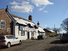
Brimstage is a village and former civil parish in the Wirral district, in the county of Merseyside, England. It is in the centremost part of the Wirral Peninsula, approximately 3 miles (4.8 km) east of Heswall and 3 miles (4.8 km) south west of Bebington. Administratively, it is within the Clatterbridge Ward and is in the parliamentary constituency of Wirral South.

<span class="mw-page-title-main">Larton</span> Hamlet in Wirral, England

Larton is a hamlet near the town of West Kirby, on the Wirral Peninsula, in Merseyside, England. Administratively it is part of the local government ward of Greasby, Frankby and Irby in the Metropolitan Borough of Wirral and is within the parliamentary constituency of Wirral West.

<span class="mw-page-title-main">Storeton</span> Human settlement in England

Storeton is a small village and former civil parish in the Wirral district, in the county of Merseyside, England, on the Wirral Peninsula. It is west of the town of Bebington and is made up of Great Storeton and Little Storeton, which is classified as a hamlet. At the 2001 Census the population of Storeton was recorded as 150.

<span class="mw-page-title-main">Gayton, Merseyside</span> Village in England

Gayton is a village in the Wirral district, in Merseyside, England, located between Heswall and Parkgate. At the 2001 Census, the population of Gayton stood at 3,110.

<span class="mw-page-title-main">Raby Mere</span> Hamlet in England

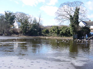
Raby Mere is a hamlet on the Wirral Peninsula, England. Adjacent to the Green Belt, woodland and open countryside, it is known for its mere, a lake that has been used for leisure purposes for many years. The hamlet of Raby is located two miles west.

<span class="mw-page-title-main">Clatterbridge</span> Hamlet in England

Clatterbridge is a hamlet on the Wirral Peninsula, in the Metropolitan Borough of Wirral, Merseyside, England. It is to the south-west of Bebington and close to the M53 motorway. Clatterbridge is also the name of a local government ward, which includes Brimstage, Raby, Raby Mere, Thornton Hough, Storeton, Spital and the western fringes of Bromborough and Eastham.

<span class="mw-page-title-main">Municipal Borough of Bebington</span>

Bebington was a local government district on the Wirral Peninsula, in Cheshire, England.

<span class="mw-page-title-main">Neston Urban District</span> Urban district in Cheshire, England

Neston Urban District was an urban district in Cheshire, England and previously known as Neston and Parkgate Urban District (1894-1933). It was the local authority for Neston and Parkgate, in the south-west of the Wirral Peninsula.

The ceremonial county of Cheshire, which comprises the unitary authorities of Cheshire East, Cheshire West and Chester, Halton and Warrington, returned 11 MPs to the UK Parliament from 1997 to 2024. Under the 2023 review of Westminster constituencies, coming into effect for the 2024 general election, the boundary commission proposed 12 constituencies, including two which crossed the border into the county of Merseyside.

References

  1. 1 2 "Wirral 2001 Census: Raby". Metropolitan Borough of Wirral. Retrieved 21 February 2008.[ dead link ]
  2. "Coordinate Distance Calculator". boulter.com. Retrieved 6 March 2016.
  3. "SRTM & Ordnance Survey Elevation Data in PHP" . Retrieved 1 November 2016.
  4. Sulley, Philip (1889). The Hundred Of Wirral.
  5. Roberts, Stephen J. (2002). A History of Wirral. The History Press Ltd. ISBN   978-1-86077-512-3.
  6. "History of Raby, in Wirral and Cheshire". A Vision of Britain through Time . Retrieved 8 August 2023.
  7. "Relationships and changes Raby CP/Tn through time". A Vision of Britain through Time. Retrieved 8 August 2023.
  8. "Wirral Registration District". UKBMD. Retrieved 8 August 2023.
  9. "Raby". GENUKI UK & Ireland Genealogy. Retrieved 15 July 2020.
  10. "Brimstage, Raby & Thornton Hough: A Strategy for Change Management" (PDF). Thornton Hough Community Trust. p. 28. Archived from the original (PDF) on 7 October 2007. Retrieved 29 August 2007.

Bibliography