
Teller is a city in the Nome Census Area, Alaska, United States. At the 2010 census the population was 229, a decrease from 268 in 2000.

The Seward Peninsula is a large peninsula on the western coast of the U.S. state of Alaska whose westernmost point is Cape Prince of Wales. The peninsula projects about 200 mi (320 km) into the Bering Sea between Norton Sound, the Bering Strait, the Chukchi Sea, and Kotzebue Sound, just below the Arctic Circle. The entire peninsula is about 210 mi (330 km) long and 90–140 mi (145–225 km) wide. Like Seward, Alaska, it was named after William H. Seward, the United States Secretary of State who fought for the U.S. purchase of Alaska.
The Koyuk River is a river on the Seward Peninsula of western Alaska, in the United States. The river originates in the interior of the peninsula, at the Lost Jim Lava Flow of the Bering Land Bridge National Preserve, where it flows southeast towards the mouth of Norton Bay on Norton Sound. The native village of Koyuk is located at its mouth. The two major tributaries are the Peace and Salmon rivers; other tributaries include Dime and Sweepstakes.

The Fish River is a waterway in the U.S. state of Alaska. The 47-mile-long (76 km) river rises in the Bendeleben Mountains and flows south to Golovnin Lagoon, before emptying into Golovnin Bay, Norton Sound, and the Bering Sea. The basin formed by the Fish River is known for its placer gold deposits, and in particular, the Niukluk River and its tributaries; production from this tributary valley is reported to be more than from any other place in the region. A galena mine existed 40 miles (64 km) from the sea, worked on occasion by a San Francisco corporation with a few hundred tons of ore taken to the city for smelting and refining for silver. Walter Curran Mendenhall found obscure fossils on Fish River at White Mountain.
The Tubutulik River is a waterway in the U.S. state of Alaska. The 25-mile (40 km) long river is situated on the Seward Peninsula. It flows southeastwards to the Kwiniuk Inlet at the northwestern end of Norton Bay, 25 miles (40 km) southwest of Koyuk in the Bering Sea. Its Inuit name was reported as "Tubuktulik" in 1849 by Capt. Mikhail Dmitrievich Tebenkov of the Imperial Russian Navy. Exploration for placer gold occurred in the Council district area where the river valley is located, and in 1898, mining commenced. The production was substantial and ranked second only to that of Nome.

Cape Nome is a headland on the Seward Peninsula in the U.S. state of Alaska. It is situated on the northern shore of Norton Sound, 15 miles (24 km) to the east of Nome also on Norton Sound. It is delimited by the Norton Sound to the south, Hastings Creek on the west, a lagoon on the east and an estuary formed by the Flambeau River and the Eldorado River. From the sea shore, Cape Nome extends inland by about 4 miles (6.4 km), connected by road with Nome.
Eldorado River is a waterway on the Seward Peninsula in the U.S. state of Alaska. It is situated 14 miles (23 km) west of Solomon. This river has its source within a few miles of Salmon Lake, from which it is separated by a low divide. It flows southeast through a broad gravel-filled valley for 30 miles (48 km) to Flambeau River before emptying into Safety Sound. Its headwaters reach the limestones of the Nome series and much of its course lies in a chlorite-albite-schist belt. The Eldorado River provides a southerly drainage into the Bering Sea.
Anikovik River is a waterway in the U.S. state of Alaska. It heads in the York Mountains about 15 miles (24 km) from the Bering Sea. As it leaves the mountains, it has a westerly course, but bending sharply to the south, it flows in that direction to the sea. It has a broad, flat flood plain, from 300 feet (91 m) to 0.5 miles (0.80 km) in width. In the upper part of its course, the river flows in greenstones, but below its bend, to the south, it cuts phyllites and slates. A rough estimate of the fall of river makes it about 15–18 feet (4.6–5.5 m) per mile. Buhner Creek joins Anakovik River about 2 miles (3.2 km) above the mouth of Deer Creek.
Nome River is a waterway on the Seward Peninsula in the U.S. state of Alaska. It has its source in a narrow valley in the southern margin of the Kigluaik Mountains, 4.5 miles (7.2 km) west of Salmon Lake.

Council City and Solomon River Railroad is an abandoned railroad in the U.S. state of Alaska. Its name refers to Solomon River and the city of Council in the Nome Census Area. The railway operated from 1903 to 1907. The remains of the railroad at Mile 31 of the Nome-Council Highway, comprising three locomotives, two flat cars and a boiler, were listed as an historic district on the National Register of Historic Places in 2001.
Agiapuk River is a waterway on the Seward Peninsula in the U.S. state of Alaska. It is a tributary to Grantley Harbor from the north. American River is a main tributary.

Norton Bay is a waterway classified bay located on the northeastern part of the Norton Sound, on the Seward Peninsula in the Nome Census Area of the Bering Sea of the U.S. state of Alaska. The mouths of several rivers debouch at Norton Bay, including the Kwik, Kwiniuk, and Tubutulik rivers.
Pinguk River is a waterway located on the Seward Peninsula in the U.S. state of Alaska. The river runs in a northwesterly direction for 34 miles (55 km) and then flows into the Arctic Lagoon about 30 miles (48 km) northeast of Cape Prince of Wales.
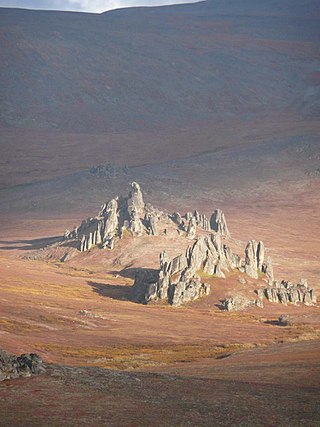
Brooks Mountain is the highest peak in the York Mountains range on the Seward Peninsula in the U.S. state of Alaska. It is located in the central part of the Teller Quadrangle, about 25 miles (40 km) east of Cape Prince of Wales. It has an elevation of 2,918 feet (889 m). It has tin ore deposits, and high-grade uranium has also been found in the form of zeunerite.
Cape Mountain (Inupiaq: Kiŋigin) is located 3 miles (4.8 km) southeast of Cape Prince of Wales on the Seward Peninsula in the U.S. state of Alaska. It was named by the surveyor, Alfred Hulse Brooks, in 1900.
Bluestone River is a waterway located on the Seward Peninsula in the U.S. state of Alaska. A tributary of the Tuksuk Channel from the south, Bluestone is a north-flowing stream situated 11 miles (18 km) southeast of Teller. It was named in 1900 by Edward Chester Barnard, topographer of the United States Geological Survey.
The Bob Blodgett Nome–Teller Memorial Highway, also known as the Nome–Teller Highway and generally referred to as simply the Teller Highway, is a well-maintained gravel road in the U.S. state of Alaska. It runs 72 miles northwest from Nome to the Inupiat village of Teller, located at the base of the sand spit that divides Port Clarence from Grantley Harbor.
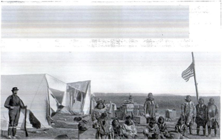
Teller Reindeer Station was located near Teller in the U.S. state of Alaska. The idea of transporting domestic reindeer from Siberia to western Alaska was first suggested by Captain Michael A. Healy, an officer in the United States Revenue Cutter Service, as a possible solution to the Native Alaskans' food shortage problem. The station was established in 1892 by Sheldon Jackson, Commissioner of Education in Alaska and a Presbyterian minister, who named it in honor of Henry M. Teller. The U.S. Government's Alaska Reindeer Service program ended in the early 1900s.
American River is a waterway in the U.S. state of Alaska. Situated on the northwestern portion of Seward Peninsula, it is the eastern and larger fork of the Agiapuk River. It joins the Agiapuk River in a broad, gravel-filled basin, and for 20 miles (32 km) up, is characterized by a wide flood plain and a meandering course. It receives a number of large tributaries from the east which also have wide floodplains developed in their lower parts. The important tributaries are Portage Creek, Budd Creek, and Igloo Creek, while smaller tributaries are Burke, Gold Run, Dome, and Camp creeks. All of these tributaries received some attention from gold prospectors. The river is easily navigable by small boats for several miles above the mouth of Portage Creek, and the region can also be reached from Teller. Gold had been discovered in the region in September 1901 and a number of the streams were known to be gold-bearing to some extent.

Alaska Reindeer Service (ARS) was established for the benefit of the U.S. territory of Alaska by Congressional action on March 3, 1893. The ARS was an integral part of the educational system of northern and western Alaska. The superintendent of education of Alaska Natives had general supervision of the work. The district superintendents in northern and western Alaska were supervisors of the reindeer industry within their districts. The first annual expenditure for the period of 1893-94 was US$5,998.

