Grassmoor

Last updated

Grassmoor
Grassmoor 259450 13df8c20.jpg
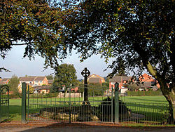
The entrance gates to Barnes Park are near the centre of Grassmoor, across the road from the village school. The war memorial stands just inside the entrance.
Derbyshire UK location map.svg
Red pog.svg
Grassmoor
Location within Derbyshire
Population3,360 (2011)
OS grid reference SK403672
Civil parish
District
Shire county
Region
Country England
Sovereign state United Kingdom
Post town CHESTERFIELD
Postcode district S42
Dialling code 01246
Police Derbyshire
Fire Derbyshire
Ambulance East Midlands
List of places
UK
England
Derbyshire
53°12′04″N1°23′49″W / 53.201°N 1.397°W / 53.201; -1.397

Grassmoor is a village in Derbyshire, England, approximately three miles to the south of Chesterfield its distance from London is 148.5 miles. Its original name, according to 16th-century parish records, was Gresmore. [1] The appropriate civil parish is called Grassmoor, Hasland and Winsick. The population of this civil parish at the 2011 Census was 3,360. [2] Grassmoor formerly housed many miners, however all of the local mines in the area have been closed since the mid-eighties.

Contents

Opposite Grassmoor Primary School is Barnes Park and the cricket pitch. Many local cricket matches are played in the park and it is also host to an annual Summer Fete.

Parish council

Grassmoor Parish Council covers the village of Grassmoor and also the areas of Winsick and Hasland. The area covered by this Parish when combined with the area covered by the Parish of Temple Normanton forms Grassmoor district electoral ward. The Parish is part of Sutton County electoral division. [3]

Five Pits Trail

The Five Pits Trail is a five and a half mile off-road surfaced route from Grassmoor Country Park to Tibshelf Ponds.

The Five Pits Trail is so named as it 5 mines that interlink local coal mines Coalfields. The former collieries had a long death, with deep mines gradually being replaced by huge opencast workings, which had a lifespan of less than 20 years. Reclamation and conservation over the past 30 years have seen spoil tips and wasteland replaced by hay meadows and woodland.

Areas of water have attracted upwards of 200 species of birds. The bird reserves at Williamthorpe Ponds are partially filled by water pumped at a constant 10 °C which attracts many birds, particularly in winter. [4]

Lagoons

Grassmoor lagoons were formed in spoil tips at the former Grassmoor Colliery, which operated on the site from the 1840s until its closure in 1967. When British Coal opened the Avenue Coking Works nearby, it used the lagoon area to treat waste liquid from the coking works. During this time, large amounts of coal tar sludge from the works settled in the lagoons. The Avenue Coking Works closed in 1993, and Derbyshire County Council took over the lagoons site later the same year. [5] Derbyshire County Council owns the Grassmoor Lagoons site and has secured funding to remediate the lagoons area. Once this is achieved, the council intends to incorporate the area back into the Grassmoor Country Park. This was due to begin in 2009, [6] however, no progress has been made as of March 2018.

Notable people

Paul Burrell grew up in the village, before eventually becoming Diana, Princess of Wales's butler.

Attractions

Grassmoor Primary School is government funded. Grassmoor Community Centre hosts community events such as small fairs.

Related Research Articles

<span class="mw-page-title-main">Staveley, Derbyshire</span> Human settlement in England

Staveley is a town and civil parish in the Borough of Chesterfield, Derbyshire, England. Located along the banks of the River Rother. It is northeast of Chesterfield, west of Clowne, northwest of Bolsover, southwest of Worksop and southeast of Sheffield.

<span class="mw-page-title-main">North East Derbyshire</span> Non-metropolitan district in England

North East Derbyshire is a local government district in Derbyshire, England. The council is based in the large village of Wingerworth. The district also includes the towns of Dronfield and Clay Cross as well as numerous villages and surrounding rural areas.

<span class="mw-page-title-main">Alveley</span> Human settlement in England

Alveley is a village in the Severn Valley in southeast Shropshire, England, about 11 miles (18 km) south-southeast of Bridgnorth. It is in the civil parish of Alveley and Romsley. The 2011 Census recorded the parish population as 2,098. It is served by bus service 297 operated by Arriva Midlands. It is most famously known as being the hometown of Jack Jones, a local magician.

<span class="mw-page-title-main">West Hallam</span> Human settlement in England

West Hallam is a large village and civil parish close to Ilkeston in the county of Derbyshire in the East Midlands region of England. West Hallam has had its own parish council since 1894 and, since 1974, has been part of the Erewash borough. The population of the civil parish was 4,829 at the 2001 census reducing to 4,686 at the 2011 census.

<span class="mw-page-title-main">Clay Cross</span> Human settlement in England

Clay Cross is a town and a civil parish in the North East Derbyshire district of Derbyshire, England. It is a former industrial and mining town, about 5 miles (8.0 km) south of Chesterfield. It is directly on the A61. Surrounding settlements include North Wingfield, Tupton, Pilsley and Ashover.

Murton is a village in County Durham, England. Lying eight miles (13 km) east of the city of Durham and six miles (9.7 km) south of Sunderland, it has a population of 4,534, increasing to 7,676 at the 2011 Census.

<span class="mw-page-title-main">Morton, Derbyshire</span> Human settlement in England

Morton is a civil parish and village, three miles north of Alfreton in North East Derbyshire, Derbyshire, England. The civil parish population at the 2011 Census was 1,195.

<span class="mw-page-title-main">Tibshelf</span> Human settlement in England

Tibshelf is a village and civil parish in the Bolsover District in Derbyshire, England. Located between the towns of Clay Cross, Shirebrook, Mansfield and Chesterfield. It had a population at the 2001 UK census of 3,548, increasing to 3,787 at the 2011 Census, and increasing to 4,348 at the 2021 Census Tibshelf shares its boundaries with the villages of Morton, Pilsley, Newton, Teversal and Hardstoft.

<span class="mw-page-title-main">Cwmbach</span> Human settlement in Wales

Cwmbach is a village and community near Aberdare, in the county borough of Rhondda Cynon Taf, Wales. Cwmbach means 'Little Valley' in Welsh. Cwmbach has a population of 5,117.

<span class="mw-page-title-main">Temple Normanton</span> Village in Derbyshire, England

Temple Normanton is a village and a civil parish in the North East Derbyshire district in Derbyshire, England. The population of the civil parish at the 2011 census was 490.

<span class="mw-page-title-main">Pilsley, North East Derbyshire</span> Human settlement in England

Pilsley is a village and civil parish in the district of North East Derbyshire in the county of Derbyshire, England. It is located near to the town of Chesterfield. At the 2011 Census the population was 3,487.

<span class="mw-page-title-main">Holmewood</span> Human settlement in England

Holmewood is a village in the North East Derbyshire district of Derbyshire, England. Historically a coal mining village, it has close links to the villages of Heath, North Wingfield and Temple Normanton. It is in the civil parish of Heath and Holmewood.

<span class="mw-page-title-main">Orgreave Colliery</span> Former coal mine in South Yorkshire, England

Orgreave Colliery was a coal mine situated adjacent to the main line of the Manchester, Sheffield & Lincolnshire Railway about 5 miles (8 km) east of Sheffield and 3.5 miles (6 km) south west of Rotherham. The colliery is within the parish of Orgreave, from which it takes its name.

<span class="mw-page-title-main">Tibshelf Town railway station</span> Former railway station in Derbyshire, England

Tibshelf Town railway station is a disused station on the former Great Central Main Line in the village of Tibshelf in Derbyshire, England.

<span class="mw-page-title-main">Five Pits Trail</span> Rail trail in Derbyshire, England

<span class="mw-page-title-main">Langold</span> Human settlement in England

Langold is a village in the civil parish of Hodsock, in the Bassetlaw district, north Nottinghamshire, England. At the 2011 census it was defined as a ward of Bassetlaw Council with a population of 2,472. It was built to provide housing for the miners of Firbeck Colliery between 1923 and 1927. Langold Lakes Country Park is situated on the south-western edge of the village.

<span class="mw-page-title-main">Winsick</span> Human settlement in England

Winsick is a hamlet in Derbyshire, England. It is located on the B6039 Mansfield Road, 2 miles south of Chesterfield. It is part of the civil parish of Grassmoor, Hasland and Winsick.

<span class="mw-page-title-main">Pilsley railway station</span> Former railway station in Derbyshire, England

Pilsley railway station is a disused station which served the village of Pilsley in Derbyshire, England. It was on the Great Central Main Line.

<span class="mw-page-title-main">Warsop Vale</span> Village in Nottinghamshire, England

Warsop Vale is a village in the Mansfield district of western Nottinghamshire, England. It is 18 miles (29 km) north of Nottingham, and 5 miles (8.0 km) north of Mansfield. It is in the civil parish of Warsop. Warsop Vale's heritage is primarily as a former mining village. It lies in the very picturesque area known as the Dukeries and is easily accessible to Clumber Park, Thoresby Park and hall, Rufford Park and the Earl of Portland estate of Welbeck, together all part of Sherwood Forest.

<span class="mw-page-title-main">Grassmoor, Hasland and Winsick</span> Civil parish in Derbyshire, England

Grassmoor, Hasland and Winsick is a civil parish within the North East Derbyshire district, which is in the county of Derbyshire, England. Named for local settlements, with a mix of a number of villages and hamlets amongst a semi-rural area, it had a population of 3,360 residents in 2011. The parish is 130 miles (210 km) north west of London, 20 miles (32 km) north of the county city of Derby, and 2 miles (3.2 km) south east of the nearest market town of Chesterfield. It shares a boundary with the borough of Chesterfield, along with the parishes of Calow, North Wingfield, Temple Normanton, Tupton as well as Wingerworth. The parish paradoxically does not include the majority of the nearby built-up suburb of Hasland which is now within an adjacent unparished area of Chesterfield.

References

  1. Grassmoor village in Derbyshire – England
  2. "Civil Parish population 2011". Neighbourhood Statistics. Office for National Statistics. Retrieved 24 March 2016.
  3. Grassmoor Community Website
  4. Five Pits Trail - AA Bike Rides
  5. Grassmoor Lagoon
  6. "Grassmoor lagoons remediation scheme". www.rsk.co.uk. Archived from the original on 23 June 2016.

Commons-logo.svg Media related to Grassmoor at Wikimedia Commons