Gravel Switch, Livingston County, Kentucky

Last updated
Gravel Switch, Kentucky
USACE Kentucky Lock and Dam.jpg
Dam, quarries, and port in area
USA Kentucky location map.svg
Red pog.svg
Gravel Switch
Location in Kentucky
Usa edcp location map.svg
Red pog.svg
Gravel Switch
Location in the United States
Coordinates: 37°00′51″N88°14′56″W / 37.01417°N 88.24889°W / 37.01417; -88.24889
Country United States
State Kentucky
County Livingston
Elevation
387 ft (118 m)
Time zone UTC-6 (Central (CST))
  Summer (DST) UTC-5 (CST)
GNIS feature ID493181 [1]

Gravel Switch is an area along the Paducah & Louisville Railway (PAL) between the Kentucky Dam on the Tennessee River and Grand Rivers in Livingston County, Kentucky, United States near the interchange of U.S. Route 62 and Kentucky Route 453. [2] The gravel of the area was prized as one of the best cementing gravels for the construction of railroad track ballast. [3] It remains a rail, barge, and transloading terminal for aggregates for Vulcan Materials Company's Grand Rivers Quarry. [4] [5] [6]

Contents

History

In the early 1900s PAL's predecessor, the Illinois Central Railroad, had a spur line (its Kentucky Division [7] ) to this locale where rock was harvested for use as track ballast for the laying of track. [8] Older maps (1936) show the spurs and surroundings. [9]

After the Kentucky Dam was built and the Tennessee River basin filled (1955 maps), half of the Gravel Switch area and part of the rail line was submerged. The rail line was re-routed over the dam [10] and through the Gravel Switch spur area, which was left above water level, [9] the elevation difference about 36 feet (11 m). [lower-alpha 1]

See also

Notes

  1. As recorded in 1906 the elevation was 351 feet (107 m) and as recorded in 1979 was 387 feet (118 m), difference of 36 feet (11 m)
    Gannett, Henry, ed. (1906). "A Dictionary of Altitudes in the United States (Department of the Interior USGS Bulletin No. 274)". U.S. Government Printing Office. Retrieved May 21, 2020.
    "Gravel Switch ID 493181". U.S. Geological Survey: Geographic Names Information Service (1976-1981). September 20, 1979. Retrieved May 21, 2020.

    Related Research Articles

    <span class="mw-page-title-main">Ohio River</span> Major river in the midwestern United States

    The Ohio River is a 981-mile-long (1,579 km) river in the United States. It is located at the boundary of the Midwestern and Southern United States, flowing in a southwesterly direction from western Pennsylvania to its mouth on the Mississippi River at the southern tip of Illinois. It is the third largest river by discharge volume in the United States and the largest tributary by volume of the north-south flowing Mississippi River, which divides the eastern from western United States. It is also the 6th oldest river on the North American continent. The river flows through or along the border of six states, and its drainage basin includes parts of 14 states. Through its largest tributary, the Tennessee River, the basin includes several states of the southeastern U.S. It is the source of drinking water for five million people.

    <span class="mw-page-title-main">Grand Rivers, Kentucky</span> City in Kentucky, United States

    Grand Rivers is a home rule-class city in Livingston County, Kentucky, in the United States. The population was 382 at the 2010 census, up from 343 in 2000. It is part of the Paducah, KY-IL Metropolitan Statistical Area.

    <span class="mw-page-title-main">Tennessee River</span> River in the southeastern United States

    The Tennessee River is the largest tributary of the Ohio River. It is approximately 652 miles (1,049 km) long and is located in the southeastern United States in the Tennessee Valley. The river was once popularly known as the Cherokee River, among other names, as the Cherokee people had their homelands along its banks, especially in what are now East Tennessee and northern Alabama. Additionally, its tributary, the Little Tennessee River, flows into it from Western North Carolina and northeastern Georgia, where the river also was bordered by numerous Cherokee towns. Its current name is derived from the Cherokee town, Tanasi, which was located on the Tennessee side of the Appalachian Mountains.

    <span class="mw-page-title-main">Cumberland River</span> River in Kentucky and Tennessee, United States

    The Cumberland River is a major waterway of the Southern United States. The 688-mile-long (1,107 km) river drains almost 18,000 square miles (47,000 km2) of southern Kentucky and north-central Tennessee. The river flows generally west from a source in the Appalachian Mountains to its confluence with the Ohio River near Paducah, Kentucky, and the mouth of the Tennessee River. Major tributaries include the Obey, Caney Fork, Stones, and Red Rivers.

    <span class="mw-page-title-main">Kentucky River</span> River in Kentucky, United States

    The Kentucky River is a tributary of the Ohio River, 260 miles (418 km) long, in the U.S. Commonwealth of Kentucky. The river and its tributaries drain much of the central region of the state, with its upper course passing through the coal-mining regions of the Cumberland Mountains, and its lower course passing through the Bluegrass region in the north central part of the state. Its watershed encompasses about 7,000 square miles (18,000 km2). It supplies drinking water to about one-sixth of the population of the Commonwealth of Kentucky.

    <span class="mw-page-title-main">Illinois Central Railroad</span> American railroad

    The Illinois Central Railroad, sometimes called the Main Line of Mid-America, was a railroad in the Central United States. Its primary routes connected Chicago, Illinois, with New Orleans, Louisiana, and Mobile, Alabama, and thus, the Great Lakes to the Gulf of Mexico. Another line connected Chicago west to Sioux City, Iowa (1870), while smaller branches reached Omaha, Nebraska (1899) from Fort Dodge, Iowa, and Sioux Falls, South Dakota (1877), from Cherokee, Iowa. The IC also ran service to Miami, Florida, on trackage owned by other railroads.

    <span class="mw-page-title-main">Nashville, Chattanooga and St. Louis Railway</span> Defunct railway company in the southeastern United States (1851-1957)

    The Nashville, Chattanooga and St. Louis Railway was a railway company that operated in the U.S. states of Kentucky, Tennessee, Alabama, and Georgia. It began as the Nashville and Chattanooga Railroad, chartered in Nashville on December 11, 1845, built to 5 ft gauge and was the first railway to operate in the state of Tennessee. By the turn of the twentieth century, the NC&StL grew into one of the most important railway systems in the southern United States.

    <span class="mw-page-title-main">Lake Barkley</span> Reservoir on the Cumberland River in Kentucky and Tennessee, United States

    Lake Barkley, a 58,000-acre (230 km2) reservoir in Livingston County, Lyon County and Trigg County in Kentucky and extending into Stewart County and Houston County in Tennessee, was impounded by the U.S. Army Corps of Engineers in 1966 upon the completion of Barkley Dam. Both the lake and the dam are named for Vice President Alben Barkley, a Kentucky native.

    <span class="mw-page-title-main">United States National Register of Historic Places listings</span> Register for landmarks in the United States

    The National Register of Historic Places in the United States is a register including buildings, sites, structures, districts, and objects. The Register automatically includes all National Historic Landmarks as well as all historic areas administered by the U.S. National Park Service. Since its introduction in 1966, more than 90,000 separate listings have been added to the register.

    <span class="mw-page-title-main">Paducah & Louisville Railway</span>

    The Paducah & Louisville Railway is a Class II railroad that operates freight service between Paducah and Louisville, Kentucky. The line is located entirely within the Commonwealth of Kentucky.

    <span class="mw-page-title-main">Big South Fork Scenic Railway</span> American heritage railroad

    The Big South Fork Scenic Railway is a heritage railroad in Stearns, Kentucky.

    <span class="mw-page-title-main">Kentucky Dam</span> Dam in Kentucky, United States

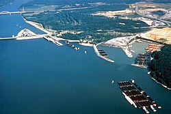
    Kentucky Dam is a hydroelectric dam on the Tennessee River on the county line between Livingston and Marshall counties in the U.S. state of Kentucky. The dam is the lowermost of nine dams on the river owned and operated by the Tennessee Valley Authority, which built the dam in the late 1930s and early 1940s to improve navigation on the lower part of the river and reduce flooding on the lower Ohio and Mississippi rivers. It was a major project initiated during the New Deal of President Franklin D. Roosevelt's administration, to invest in infrastructure to benefit the country. The dam impounds the Kentucky Lake of 160,000 acres (65,000 ha), which is the largest of TVA's reservoirs and the largest artificial lake by area in the Eastern United States. It was designated as an National Historic Civil Engineering Landmark by the American Society of Civil Engineers in 1996 and listed on the National Register of Historic Places in 2017.

    <span class="mw-page-title-main">Ohio River flood of 1937</span> 1937 flood

    The Ohio River flood of 1937 took place in late January and February 1937. With damage stretching from Pittsburgh, Pennsylvania, to Cairo, Illinois, 385 people died, one million people were left homeless and property losses reached $500 million. Federal and state resources were strained to aid recovery as the disaster occurred during the depths of the Great Depression and a few years after the beginning of the Dust Bowl.

    <span class="mw-page-title-main">Calvert City, Kentucky</span> City in Kentucky, United States

    Calvert City is a home rule-class city in Marshall County, Kentucky, United States. The population was 2,514 at the 2020 census.

    <span class="mw-page-title-main">Lincoln Heritage Council</span> Local council of the Boy Scouts of America

    The Lincoln Heritage Council (LHC) is a local council of the Boy Scouts of America serving 64 counties in four states: Kentucky, Indiana, Illinois, and Tennessee.

    The former Louisville and Nashville Railroad Lebanon Branch was 77 miles long and ran from Lebanon Junction in Bullitt County to near Mt. Vernon in Rockcastle County. Construction of the branch began in 1857, reaching Lebanon in that year. The line was extended to Crab Orchard in 1866 and completed in 1868. Most of the line was abandoned in 1987. The portion from Stanford to Mt. Vernon was abandoned during the 1990s.

    References

    1. U.S. Geological Survey Geographic Names Information System: Gravel Switch, Livingston County, Kentucky
    2. "Railway Age". Simmons-Boardman. May 19, 1928. p. 658 via Google Books. Tracks in Kentucky and on the south 70 miles in Illinois are ballasted with a cementing gravel obtained from Gravel Switch, Ky., on the Tennessee river 20 miles east of Paducah. About 3,000 cu. yd. was applied per mile.
    3. Charles Henry Richardson (1920). The Kentucky Geological Survey, Series Six Volume One, The Glass Sands of Kentucky 1920. p. 106. Gravel Switch is on the Illinois Central Railroad about two miles below Grand Rivers. There is not only a flag stop by that name, but a switch that sends the freight trains to exceedingly valuable gravel beds. The gravel beds are more than 1,000 feet in length and 50 feet in thickness above the present level of the railroad tracks. (1) There is one gravel bed more than 1,000 feet in length close to the Gravel Switch which has been temporarily abandoned. (2) A second gravel bed just above Gravel Switch. (3) A third gravel bed of more than 1,000 feet in length now operated by the Illinois Central Railroad. ... The gravel is broken down by explosives and loaded by steam shovels into cars for shipment as railroad ballast and for the manufacture of concrete. When this product is used as ballast it soon becomes as hard as concrete. When shipped to Birmingham, Alabama, it becomes hard like cement before reaching its destination. It is the largest and best gravel deposit known by the author. ... This material is of great value in the manufacture of permanent roads for it has high resistance to abrasion and high cementing power.
    4. "Reed Mine (Grand Rivers Quarry; Vulcan Materials), Livingston Co., Kentucky, USA". www.mindat.org.
    5. Minerals Yearbook. The Bureau of Mines USGS. May 21, 2009. p. 191. ISBN   9781411323292 via Google Books.
    6. "Lower Cumberland and Tennessee Rivers Navigation Feasibility Report, Kentucky Lock Addition: Environmental Impact Statement". 1992. Retrieved May 20, 2020. Most of the land surrounding the embayment east of the campground is leased to Reed Crushed Stone for use as a barge and rail shipping terminal for their aggregate operation. A spur line of the Paducah ad Louisville Railroad bisects this quadrant to give access to the Reed Terminal and beyond to the community of Grand Rivers.
    7. Illinois Central Magazine, vol. 46–47, Illinois Central Magazine, 1957, p. 39, ...worked on the Kentucky Division in 1902 as operator at Gravel Switch
    8. Works), United States Office of the Assistant Secretary of the Army (Civil (May 19, 1999). "Lower Cumberland and Tennessee Rivers, Kentucky Lock Addition: Communication from the Assistant Secretary of the Army (Civil Works), Transmitting a Letter from the Chief of Engineers, Department of the Army, Dated June 1, 1992, Submitting a Report Together with Accompanying Papers and Illustrations". U.S. Government Printing Office. pp. 626–627 via Google Books. 6.03 As illustrated by the aerial photos which pre-date construction of the dam (Figures 2 & 3), most land use in the area prior to construction of the lock and dam was related to either agricultural or forest production. Generally the flatter land south of the river was more agriculturally oriented, while the steeper topography north of the river contained more timberland. Apparently a smaller gravel operation existed even at this early date, on the north side of the river, in fact a spur rail line (gravel switch) is indicated on Figure 2, between the dam-site and the community of Grand Rivers.
    9. 1 2 "Get Maps (Compare 1936 map to 1955)". USGS Topoview.
    10. Gary W. Dolzall and Jerry Mart (March 1988). "The Paducah & Louisville A heritage of coal, crushed stone, and HO scale" (PDF). Trains. Retrieved May 20, 2020. Between Paducah and Princeton, the P&L is a relatively flat railroad...the railroad coexists with waterways, crossing Kentucky Lake (Tennessee River)...Barkley Lake (Cumberland River) 3 miles farther east...Construction of both of these lakes necessitated IC line relocations, at partial government expense, from bridge crossings to usage of the dams' causeways. Kentucky Lake was formed in 1944...)[ permanent dead link ]