Great Limber Priory, Limber Magna was a priory in Great Limber (or Limber Magna), Lincolnshire, England.
Great Limber is a village and civil parish in the West Lindsey district of Lincolnshire, England. The population of the civil parish at the 2011 census was 271. It is situated on the A18, 8 miles (13 km) west from Grimsby and 8 miles east from Brigg.
Lincolnshire is a county in eastern England, with a long coastline on the North Sea to the east. It borders Norfolk to the south east, Cambridgeshire to the south, Rutland to the south west, Leicestershire and Nottinghamshire to the west, South Yorkshire to the north west, and the East Riding of Yorkshire to the north. It also borders Northamptonshire in the south for just 20 yards (18 m), England's shortest county boundary. The county town is the city of Lincoln, where the county council has its headquarters.
England is a country that is part of the United Kingdom. It shares land borders with Wales to the west and Scotland to the north-northwest. The Irish Sea lies west of England and the Celtic Sea lies to the southwest. England is separated from continental Europe by the North Sea to the east and the English Channel to the south. The country covers five-eighths of the island of Great Britain, which lies in the North Atlantic, and includes over 100 smaller islands, such as the Isles of Scilly and the Isle of Wight.
The manor and church of Great Limber were granted by Richard de Humet, constable of Normandy, France, and Agnes his wife, to the Cistercian abbey of Aunay in Normandy, and their charter was confirmed by King Henry II in 1157. It is uncertain whether it was a priory or a grange. The manor and church were sold by the abbot of Aunay in 1393 to the priory of St. Anne at Coventry. [1]
Aunay-sur-Odon is a former commune in the Calvados department in the Normandy region of north-western France. On 1 January 2017, it was merged into the new commune Les Monts d'Aunay.
A priory is a monastery of men or women under religious vows that is headed by a prior or prioress. Priories may be houses of mendicant friars or nuns, or monasteries of monks or nuns. Houses of canons regular and canonesses regular also use this term, the alternative being "canonry".
Coventry is a city and metropolitan borough in the West Midlands, England.
see also
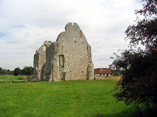
Boxgrove Priory is a ruined priory in the village of Boxgrove in Sussex. It was founded in the 12th century.
Croxden Abbey, also known as "Abbey of the Vale of St. Mary at Croxden", was a Cistercian abbey at Croxden, Staffordshire, United Kingdom. A daughter house of the abbey in Aunay-sur-Odon, Normandy, the abbey was founded by the de Verdun family in the 12th century. The abbey was dissolved in 1538.
Stone is a village in Buckinghamshire, England. It is located southwest of the town of Aylesbury, on the A418 road that links Aylesbury to Thame. Stone with Bishopstone and Hartwell is a civil parish within Aylesbury Vale district and also incorporates the nearby settlements of Bishopstone and Hartwell.
Bottesford Preceptory was sited at Bottesford, just to the south of Scunthorpe, in Lindsey, England. It was on low-lying land, near the Bottesford Beck, about 3 miles (5 km) to the west of the escarpment of the Lincoln Cliff limestone upland, and about the same distance to the east of the River Trent. A preceptory was a community of the Knights Templar who lived on one of that order's estates in the charge of its preceptor. A preceptory also referred to the estate and its buildings. The present Bottesford Manor is believed to have been the gatehouse to the preceptory.
Cogges is an area beside the River Windrush in Witney, Oxfordshire, 0.5 miles (800 m) east of the town centre. It had been a separate village and until 1932 it was a separate civil parish.
Great Glen railway station was built by the Midland Railway in 1857 on its extension from Leicester to Bedford and Hitchin.
Hoveringham is a small village and civil parish in Nottinghamshire about 10 miles (16 km) northeast of Nottingham and on the west side of the River Trent, just off the A612 trunk road to Southwell. The population of the civil parish as taken at the 2011 Census was 359. The adjacent area has extensive sand and gravel deposits which have been quarried there for many years.
The Abbey of Sainte-Trinité, also known as Abbaye aux Dames, is a former monastery of women in Caen, Normandy, now home to the Regional Council of Lower Normandy. The complex includes the Abbey Church of Sainte-Trinité.
The Priory of St. Andrews of the Ards (Blackabbey) was a Benedictine Abbey at Stogursey in Somerset.
Culgaith is a village and civil parish in the Eden District of Cumbria, England. It is located on the River Eden, between Temple Sowerby and Langwathby. Amenities include All Saints Church, and its associated primary school, as well as a pub and garden centre. The village had a railway station, which closed in 1970.
Newton Longville Priory was an alien priory in Newton Longville, Buckinghamshire, England. It was established in the 1150s and was dissolved in 1441.
Modbury Priory was a Benedictine priory in the parish of Modbury, Devon, England, established before 1129 which was one of the longest surviving alien priories in England, most of which were suppressed in 1414. It was located close to the present parish church of St George in the town of Modbury, but its exact location is unclear.
Cammeringham Priory was a priory in Cammeringham, Lincolnshire, England.
Covenham Priory was a priory in Covenham St Bartholomew, Lincolnshire, England.
Great Limber Preceptory, Limber Magna was a Camera (farm) of the Knights Templar and later the Knights Hospitaller in the village of Great Limber, Lincolnshire, England.
Heynings Priory was a priory in Knaith, Lincolnshire, England.
Everdon Priory was a priory in Northamptonshire, England. The village of Everdon is located about 6 km south-east of the town of Daventry.
Priory Cottages is a 14th-century manor house and former monastic grange which had the status of a priory at Steventon in the English county of Oxfordshire.
Horsley Priory was a medieval, monastic house in Gloucestershire, England.
Sheen Priory in Sheen, now Richmond, London, was a Carthusian monastery founded in 1414 within the royal manor of Sheen, on the south bank of the Thames, upstream and approximately 9 miles southwest of the Palace of Westminster. It was built on a site approximately half a mile to the north of Sheen Palace, which itself also occupied a riverside site, that today lies between Richmond Green and the River Thames.
Coordinates: 53°33′39″N0°16′59″W / 53.5607°N 0.2830°W
A geographic coordinate system is a coordinate system that enables every location on Earth to be specified by a set of numbers, letters or symbols. The coordinates are often chosen such that one of the numbers represents a vertical position and two or three of the numbers represent a horizontal position; alternatively, a geographic position may be expressed in a combined three-dimensional Cartesian vector. A common choice of coordinates is latitude, longitude and elevation. To specify a location on a plane requires a map projection.
This article about a Lincolnshire building or structure is a stub. You can help Wikipedia by expanding it. |
This article about a British Christian monastery, abbey, priory or other religious house is a stub. You can help Wikipedia by expanding it. |