Nuncotham Priory

Last updated
Site of Nuncotham Priory Site of the Priory of St. Mary, Nuncotham - geograph.org.uk - 572691.jpg
Site of Nuncotham Priory

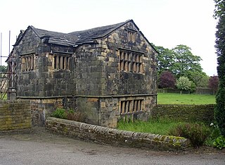
Nuncotham Priory was a priory of Cistercian nuns in Brocklesby, Lincolnshire, England.

Brocklesby village and civil parish in Lincolnshire, England

Brocklesby is a village and civil parish in the West Lindsey district of Lincolnshire, England. It is situated 1 mile (1.6 km) south from Habrough, 4 miles (6.4 km) south-west from Immingham, and is located close to the border of both North Lincolnshire and North East Lincolnshire and is the most northerly village within non-metropolitan Lincolnshire and is also near Humberside International Airport.

Lincolnshire County of England

Lincolnshire is a county in eastern England, with a long coastline on the North Sea to the east. It borders Norfolk to the south east, Cambridgeshire to the south, Rutland to the south west, Leicestershire and Nottinghamshire to the west, South Yorkshire to the north west, and the East Riding of Yorkshire to the north. It also borders Northamptonshire in the south for just 20 yards (18 m), England's shortest county boundary. The county town is the city of Lincoln, where the county council has its headquarters.

The priory of Nuncotham in Brocklesby parish was founded by Alan de Moncels around 1150. Throughout its history the Bishops complained that the nuns lived a little too freely. Joan Thompson, the last prioress, had a habit of keeping her own family at the convents expense, and the sisters had a habit of going out to visit friends.

It was Dissolved in 1539. [1]

There are earthworks covering a wide area which indicate the remains of building sites, fishponds, and several moat-like features. The site is scheduled. [2]

Earthworks (archaeology) General term to describe artificial changes in land level

In archaeology, earthworks are artificial changes in land level, typically made from piles of artificially placed or sculpted rocks and soil. Earthworks can themselves be archaeological features, or they can show features beneath the surface.

Scheduled monument nationally important archaeological site or historic building in the United Kingdom

In the United Kingdom, a scheduled monument is a "nationally important" archaeological site or historic building, given protection against unauthorised change.

Related Research Articles

Handale village in United Kingdom

Handale is a village, that is 2 miles (3 km) south of Loftus, in the borough of Redcar and Cleveland and the ceremonial county of North Yorkshire, England.

Nunburnholme Priory was a priory of Benedictine nuns in the East Riding of Yorkshire, England. It was founded during the reign of Henry II of England by an ancestor of Robert de Merlay, lord of Morpeth. Except for its demesne, it possessed only little property in its surroundings. In 1313 the prioress claimed the monastery of Seton in Coupland as a cell of Nunburnholme. In 1521 only five nuns and the prioress lived here, and on 11 August 1536 the house was suppressed. It was valued as the poorest and smallest of the Benedictine nunneries in Yorkshire surviving until then.

Swine Priory

Swine Priory was a priory in the village of Swine in the East Riding of Yorkshire, England.

Tulketh Priory was a priory in Ashton-on-Ribble, Lancashire, England. The priory was the home of a group of Cistercian monks from Savigny Abbey in Normandy until they moved to Furness Abbey in 1127. Tulketh Hall was later built on the site of the priory.

Bullington Priory

Bullington Priory was a priory in Bullington, Lincolnshire, England.

Cammeringham Priory was a priory in Cammeringham, Lincolnshire, England.

Catley Priory was a monastic house in Walcott, Lincolnshire, England.

Gokewell Priory was a Cistercian Catholic priory in Broughton, Lincolnshire, England..

Great Limber Preceptory, Limber Magna was a Camera (farm) of the Knights Templar and later the Knights Hospitaller in the village of Great Limber, Lincolnshire, England.

Greenfield Priory was a Cistercian priory in Greenfield, near Aby, Lincolnshire, England.

Heynings Priory was a priory in Knaith, Lincolnshire, England.

Legbourne Priory was a priory in the village of Legbourne, Lincolnshire, England.

North Ormsby Priory human settlement in United Kingdom

North Ormsby Priory was a Gilbertine priory in North Ormsby, Lincolnshire, England.

Orford Priory was a priory in Stainton le Vale, Lincolnshire, England.

Stixwould Priory was a priory in Lincolnshire, England.

Rosedale Priory

Rosedale Priory was a priory in Rosedale Abbey, North Yorkshire, England that was founded c. 1150–1199. By the time the priory was suppressed in 1535, it had one prioress and eight nuns. The religious house in Rosedale was a priory and not an abbey, despite the village being given the name Rosedale Abbey, and it is unsure why this came about.

Esholt Priory was a Cistercian priory in West Yorkshire, England. Esholt Hall now stands on the site of the priory.

Kirklees Priory human settlement in United Kingdom

Kirklees Priory was a Cistercian nunnery whose site is in the present-day Kirklees Park, Clifton near Brighouse, West Yorkshire, England. It was originally in the ancient ecclesiastical parish of Dewsbury. The priory dedicated to the Virgin Mary and St James was founded by Reiner le Fleming, Lord of the manor of Wath upon Dearne, in 1155 during the reign of Henry II.

Syningthwaite Priory was a priory in West Yorkshire, England. Syningthwaite is the site of the Cistercian convent of St Mary, founded c1160 by Bertram Haget and suppressed in 1535, having been heavily in debt in the early C16. At the Dissolution there were 9 nuns, the prioress, 8 servants and other labourers. The priory site is enclosed by a moat and includes a Chapel Garth.

References

  1. "The priory of Nuncotham". Houses of Cistercian nuns. Victoria County History. Retrieved 5 August 2011.
  2. Historic England. "Nun Cotham Priory (80450)". PastScape. Retrieved 5 August 2011.

Coordinates: 53°35′05″N0°15′25″W / 53.58463°N 0.25701°W / 53.58463; -0.25701

Geographic coordinate system Coordinate system

A geographic coordinate system is a coordinate system that enables every location on Earth to be specified by a set of numbers, letters or symbols. The coordinates are often chosen such that one of the numbers represents a vertical position and two or three of the numbers represent a horizontal position; alternatively, a geographic position may be expressed in a combined three-dimensional Cartesian vector. A common choice of coordinates is latitude, longitude and elevation. To specify a location on a plane requires a map projection.