Maltby Preceptory

Last updated

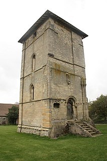
Maltby Preceptory was a house of the Knights Hospitaller in the village of Maltby, Lincolnshire, England. There are two differing accounts regarding its history.

Maltby, Lincolnshire village in United Kingdom

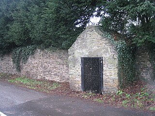
Maltby is a hamlet in the East Lindsey district of Lincolnshire, England. It forms part of Raithby cum Maltby civil parish, and is situated on the A153, 3 miles (5 km) south-west from Louth. It is in the civil parish of Tathwell.

Lincolnshire County of England

Lincolnshire is a county in eastern England, with a long coastline on the North Sea to the east. It borders Norfolk to the south east, Cambridgeshire to the south, Rutland to the south west, Leicestershire and Nottinghamshire to the west, South Yorkshire to the north west, and the East Riding of Yorkshire to the north. It also borders Northamptonshire in the south for just 20 yards (18 m), England's shortest county boundary. The county town is the city of Lincoln, where the county council has its headquarters.

England Country in north-west Europe, part of the United Kingdom

England is a country that is part of the United Kingdom. It shares land borders with Wales to the west and Scotland to the north-northwest. The Irish Sea lies west of England and the Celtic Sea lies to the southwest. England is separated from continental Europe by the North Sea to the east and the English Channel to the south. The country covers five-eighths of the island of Great Britain, which lies in the North Atlantic, and includes over 100 smaller islands, such as the Isles of Scilly and the Isle of Wight.

It was established as a house for the during the reign of King Stephen around 1135-54 by Ranulf, Earl of Chester and included the church and Maltby, and land both there and in the villages of Tathwell and Rauceby. [1] [2] It closed at the dissolution of the Monasteries around 1540. [1]

Tathwell human settlement in United Kingdom

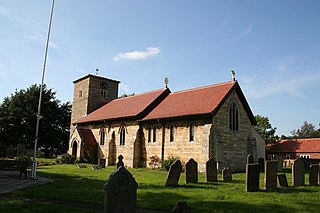
Tathwell is a village in the East Lindsey district of Lincolnshire, England.

South Rauceby village in the United Kingdom

South Rauceby is a village and civil parish in the North Kesteven district of Lincolnshire, England. It is situated 2.5 miles (4.0 km) west from Sleaford. The village of North Rauceby is less than 1 mile (1.6 km) to the north. The 2001 Census recorded a village population of 330 in 161 household, increasing to 367 at the 2011 census.

Dissolution of the Monasteries legal event which disbanded religious residences in England, Wales and Ireland

The Dissolution of the Monasteries, sometimes referred to as the Suppression of the Monasteries, was the set of administrative and legal processes between 1536 and 1541 by which Henry VIII disbanded monasteries, priories, convents and friaries in England, Wales and Ireland, appropriated their income, disposed of their assets, and provided for their former personnel and functions. Although the policy was originally envisaged as increasing the regular income of the Crown, much former monastic property was sold off to fund Henry's military campaigns in the 1540s. He was given the authority to do this in England and Wales by the Act of Supremacy, passed by Parliament in 1534, which made him Supreme Head of the Church in England, thus separating England from Papal authority, and by the First Suppression Act (1535) and the Second Suppression Act (1539).

The Monastica Anglicanum claims it was a house of the Knights Templar and passed into the hands of the Hospitallers after the Templars were suppressed in 1312. [2]

Related Research Articles

Temple Bruer Preceptory village in the United Kingdom

Temple Bruer Preceptory is in a farm-yard in the civil parish of Temple Bruer with Temple High Grange, North Kesteven, Lincolnshire, England. It is one of the few Knights Templar sites left in England where any ruins remain standing. Its name comes from its Templar ownership and its position in the middle of the Lincoln Heath, bruyère (heather) from the French language current at the time. It was founded in the period 1150 to 1160 and the order was dissolved in 1312. The site is at grid reference TF 0085 5370, located between the A15 and A607 roads, 2.5 miles (4.0 km) north from Cranwell. The site has been excavated twice, firstly by the Rev Dr. G. Oliver, the rector of Scopwick in 1832-3, and in 1908 by Sir William St John Hope.

Eagle, Lincolnshire village in United Kingdom

Eagle is a village in the North Kesteven district of Lincolnshire, England. It is situated 7 miles (11 km) south-west from Lincoln and 2 miles (3.2 km) east from North Scarle. Eagle is part of the civil parish of Eagle and Swinethorpe. The population of the civil parish taken at the 2011 census was 793.

Bottesford Preceptory

Bottesford Preceptory was sited at Bottesford, just to the south of Scunthorpe, in Lindsey, England. It was on low-lying land, near the Bottesford Beck, about 3 miles (5 km) to the west of the escarpment of the Lincoln Cliff limestone upland, and about the same distance to the east of the River Trent. A preceptory was a community of the Knights Templar who lived on one of that order's estates in the charge of its preceptor. A preceptory also referred to the estate and its buildings. The present Bottesford Manor is believed to have been the gatehouse to the preceptory.

Aslackby Preceptory

Aslackby Preceptory in Lincolnshire lay to the south-east of Aslackby Church. Until about 1891 a tower, possibly of the preceptory church, together with a vaulted undercroft, survived as part the Temple farmhouse. Temple farmhouse was subsequently rebuilt and a 15th-century window and a stone pinnacle remain in the garden

Rothley Temple Grade I listed commandry in the United Kingdom

Rothley Temple, or more correctly Rothley Preceptory, was a preceptory in the village of Rothley, Leicestershire, England, associated with both the Knights Templar and the Knights Hospitaller.

The Faxfleet Preceptory is a former community of the Knights Templar located in what is now the East Riding of Yorkshire, England. It stood on lands which are now part of Thorpe Grange Farm and are largely buried under a field to the west of the farm known today as Temple Garth. The location is west of Kingston upon Hull, approximately 20 miles south of Youlthorpe and 25 miles south-west of Beswick.

Aslackby and Laughton civil parish in Lincolnshire

Aslackby and Laughton is a civil parish in the South Kesteven district of Lincolnshire, England. According to the 2001 census the parish had a population of 243, in 102 households. increasing slightly to 251 in 118 households at the 2011 census. It consists of the village of Aslackby, the hamlet of Laughton, and scattered farms.

Templecombe Preceptory human settlement in United Kingdom

Templecombe Preceptory was established in 1185 in Templecombe, Somerset, England.

Great Limber Preceptory, Limber Magna was a Camera (farm) of the Knights Templar and later the Knights Hospitaller in the village of Great Limber, Lincolnshire, England.

Willoughton Preceptory

Willoughton Preceptory was a holding of the Knights Templar in Lincolnshire, England. The preceptory stood at the farm still called Temple Garth.

Ribston Preceptory was a priory just east of the village of Little Ribston, in North Yorkshire, England on the east bank of the River Nidd. The preceptory at Ribston was founded in 1217, when Robert de Ros donated the land and advowson of Ribston to the Knights Templar.

Snainton Preceptory was a priory, just south of the village of Snainton, in North Yorkshire, England. The preceptory was started by the Knights Templar at Foulbridge which sits 1-mile (2 km) to the east of a Benedictine Priory at Yedingham. Both houses were on the River Derwent.

Westerdale Preceptory was a priory in Westerdale, North Yorkshire, England. The land was donated to the Knights Templar by Guido de Bovingcourt in 1203, and was one of ten preceptories owned by the Knights Templar in Yorkshire. The Templars worked the land and farmed at Westerdale until their suppression for heresy in 1307-1308.

Wetherby Preceptory was a medieval monastic house in Wetherby, West Yorkshire, England. The estate at Wetherby was given to the Templars around 1240 and was held by them until they were suppressed in 1308. Thereafter it was held by the Knights Hospitaller until 1538.

Copmanthorpe Preceptory, York was a medieval monastic house in North Yorkshire, England.

Witham Preceptory

The site of the former preceptory at Temple Hill, South Witham. It 'has been largely under pasture' since the Knights Templar left in 1308.]] Withham Preceptory, one of the smallest Knights Templar preceptories in England, was founded, before 1164, at Temple Hill, near South Witham, Lincolnshire, and was abandoned in the early 14th century.

Temple Hirst is a village and civil parish in the Selby District of North Yorkshire, England. It was formerly in the Barkston Ash wapentake in the West Riding of Yorkshire. The village is located on the north bank of the River Aire. In the 2011 census the population was 120.

References

  1. 1 2 "British History Online". Houses of Knights Hospitallers. Victoria County History. Retrieved 24 May 2011.
  2. 1 2 Historic England. "Maltby Hospitallers Preceptory (354643)". PastScape. Retrieved 25 May 2011.

Coordinates: 53°20′25″N0°02′13″W / 53.3403°N 0.0369°W / 53.3403; -0.0369

Geographic coordinate system Coordinate system

A geographic coordinate system is a coordinate system that enables every location on Earth to be specified by a set of numbers, letters or symbols. The coordinates are often chosen such that one of the numbers represents a vertical position and two or three of the numbers represent a horizontal position; alternatively, a geographic position may be expressed in a combined three-dimensional Cartesian vector. A common choice of coordinates is latitude, longitude and elevation. To specify a location on a plane requires a map projection.