Stainfield Priory

Last updated
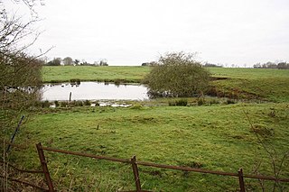
site of former Priory Stainfield - geograph.org.uk - 242587.jpg
site of former Priory

Stainfield Priory was a Benedictine nunnery at Stainfield in the North of Lincolnshire, England, between Wragby and Fiskerton.

Stainfield human settlement in United Kingdom

Stainfield is a village and civil parish about 10 miles (16 km) east of the city of Lincoln, in the West Lindsey district of Lincolnshire, England. The population of the civil parish at the 2011 census was 189.

Lincolnshire County of England

Lincolnshire is a county in eastern England, with a long coastline on the North Sea to the east. It borders Norfolk to the south east, Cambridgeshire to the south, Rutland to the south west, Leicestershire and Nottinghamshire to the west, South Yorkshire to the north west, and the East Riding of Yorkshire to the north. It also borders Northamptonshire in the south for just 20 yards (18 m), England's shortest county boundary. The county town is the city of Lincoln, where the county council has its headquarters.

England Country in north-west Europe, part of the United Kingdom

England is a country that is part of the United Kingdom. It shares land borders with Wales to the west and Scotland to the north-northwest. The Irish Sea lies west of England and the Celtic Sea lies to the southwest. England is separated from continental Europe by the North Sea to the east and the English Channel to the south. The country covers five-eighths of the island of Great Britain, which lies in the North Atlantic, and includes over 100 smaller islands, such as the Isles of Scilly and the Isle of Wight.

The priory of St Mary at Stainfield was the only nunnery of the Benedictine order in Lincolnshire. It was a small establishment intended to house up to 20 nuns, founded in around 1154 by Henry or William Percy, which survived until the dissolution in 1536. [1] [2]


Related Research Articles

Wothorpe

Wothorpe is a village and civil parish in the Peterborough unitary authority of Cambridgeshire, England. It is in the far north-west of the district, and to the south of Stamford. The parish borders Northamptonshire on its west.

Bardney Abbey

Bardney Abbey in Lincolnshire, England, was a Benedictine monastery founded in 697 by King Æthelred of Mercia, who was to become the first abbot. The monastery was supposedly destroyed during a Danish raid in 869. In 1087, the site was refounded as a priory, by Gilbert de Gant, Earl of Lincoln, and it regained status as an abbey in 1115.

Cannington Nunnery human settlement in United Kingdom

Cannington Nunnery was established around 1138 and dissolved in 1536 in Cannington, Somerset, England.

Nunburnholme Priory was a priory of Benedictine nuns in the East Riding of Yorkshire, England. It was founded during the reign of Henry II of England by an ancestor of Robert de Merlay, lord of Morpeth. Except for its demesne, it possessed only little property in its surroundings. In 1313 the prioress claimed the monastery of Seton in Coupland as a cell of Nunburnholme. In 1521 only five nuns and the prioress lived here, and on 11 August 1536 the house was suppressed. It was valued as the poorest and smallest of the Benedictine nunneries in Yorkshire surviving until then.

Swine Priory

Swine Priory was a priory in the village of Swine in the East Riding of Yorkshire, England.

Bonby Priory

Bonby Priory was a priory in Lincolnshire, England. St. Andrews Church is all that remains of Bonby Priory, which was a Benedictine alien cell of St. Fromond Priory from 1199 to 1403. The priory was then rented to Beauvale Abbey, (Nottinghamshire), and later, the church became parochial.

Burwell Priory

Burwell Priory was a priory in the village of Burwell, Lincolnshire, England.

Covenham Priory was a priory in Covenham St Bartholomew, Lincolnshire, England.

Deeping St James Priory

Deeping St James Priory was a priory in Deeping St James, Lincolnshire, England. In 1139 Baldwin Fitz Gilbert established the Benedictine Priory of Saint James at Deeping as a cell of Thorney Abbey. The cell was dissolved at the surrender of Thorney in 1539. The priory church remains as the Church of England parish church of Deeping St James and is a Grade I listed building.

Gokewell Priory was a Cistercian Catholic priory in Broughton, Lincolnshire, England..

Haugham Priory was a Benedictine priory in Lincolnshire, England.

Minting Priory human settlement in United Kingdom

Minting Priory was a priory in Minting, Lincolnshire, England.

St Leonards Priory, Stamford Grade I listed priory in South Kesteven, United Kingdom

St Leonard's Priory, Stamford was a priory in Lincolnshire, England. It was built in Stamford, supposedly on the site of a monastery which was founded by St Wilfrid in 658 and destroyed in the Danish invasion.

Skendleby Priory was a priory in the village of Skendleby, Lincolnshire, England.

Stixwould Priory was a priory in Lincolnshire, England.

Wothorpe Priory was a monastic house in Northamptonshire, England but adjacent to Stamford, Lincolnshire. It was a "small Benedictine nunnery", founded apparently around 1160. All but one of the nuns died in the outbreak of plague in 1349, with the survivor becoming part of the Priory of Stamford. The property was dissolved by Henry VIII, being granted to Richard Cecil.

References

Both references contain a wealth of further detail.

  1. Historic England. "Stainfield Priory (351572)". PastScape. Retrieved 25 March 2015.
  2. Page, William, ed. (1906). A History of the County of Lincoln. Victoria County History. 2. pp. 131–132.

Coordinates: 53°14′39″N0°20′12″W / 53.24426°N 0.33663°W / 53.24426; -0.33663 (SAP Production)

Geographic coordinate system Coordinate system

A geographic coordinate system is a coordinate system that enables every location on Earth to be specified by a set of numbers, letters or symbols. The coordinates are often chosen such that one of the numbers represents a vertical position and two or three of the numbers represent a horizontal position; alternatively, a geographic position may be expressed in a combined three-dimensional Cartesian vector. A common choice of coordinates is latitude, longitude and elevation. To specify a location on a plane requires a map projection.