Green Meadows, Ohio

Last updated
Green Meadows, Ohio
OHMap-doton-Green Meadows.png
Location of Green Meadows, Ohio
Coordinates: 39°52′15″N83°56′38″W / 39.87083°N 83.94389°W / 39.87083; -83.94389
Country United States
State Ohio
County Clark
Township Mad River
Area
[1]
  Total0.80 sq mi (2.06 km2)
  Land0.80 sq mi (2.06 km2)
  Water0.00 sq mi (0.00 km2)
Elevation
[2]
906 ft (276 m)
Population
 (2020)
  Total2,373
  Density2,984.91/sq mi (1,152.44/km2)
Time zone UTC-5 (Eastern (EST))
  Summer (DST) UTC-4 (EDT)
FIPS code 39-32207 [3]
GNIS feature ID2393028 [2]

Green Meadows is a census-designated place (CDP) in Mad River Township, Clark County, Ohio, United States, on the west side of Enon. The population was 2,373 at the 2020 census. It is part of the Springfield, Ohio Metropolitan Statistical Area.

Contents

Geography

Green Meadows is located in southwestern Clark County near the center of Mad River Township. It is bordered on the east by the village of Enon and on the southwest by unincorporated Holiday Valley. Dayton Springfield Road forms the northwestern edge of the community, leading northeast through the center of Enon 8 miles (13 km) to the center of Springfield. Dayton is 17 miles (27 km) to the southwest.

According to the United States Census Bureau, the Green Meadows CDP has a total area of 0.81 square miles (2.1 km2), all of it land. [4]

Demographics

Historical population
CensusPop.Note
2020 2,373
U.S. Decennial Census [5]

As of the census [3] of 2000, there were 2,318 people, 917 households, and 674 families residing in the CDP. The population density was 3,807.8 inhabitants per square mile (1,470.2/km2). There were 943 housing units at an average density of 1,549.1 per square mile (598.1/km2). The racial makeup of the CDP was 97.33% White, 0.86% African American, 0.04% Native American, 0.69% Asian, 0.17% from other races, and 0.91% from two or more races. Hispanic or Latino of any race were 0.91% of the population.

There were 917 households, out of which 33.7% had children under the age of 18 living with them, 59.7% were married couples living together, 10.7% had a female householder with no husband present, and 26.4% were non-families. 22.1% of all households were made up of individuals, and 7.0% had someone living alone who was 65 years of age or older. The average household size was 2.53 and the average family size was 2.98.

In the CDP the population was spread out, with 25.1% under the age of 18, 8.5% from 18 to 24, 31.2% from 25 to 44, 24.8% from 45 to 64, and 10.4% who were 65 years of age or older. The median age was 35 years. For every 100 females there were 95.6 males. For every 100 females age 18 and over, there were 94.6 males.

The median income for a household in the CDP was $41,071, and the median income for a family was $48,500. Males had a median income of $37,383 versus $27,188 for females. The per capita income for the CDP was $18,699. About 2.6% of families and 4.5% of the population were below the poverty line, including 6.1% of those under age 18 and 2.1% of those age 65 or over.

Education

The school district is Greenon Local School District. [6]

Related Research Articles

<span class="mw-page-title-main">Clark County, Ohio</span> County in Ohio, United States

Clark County is a county located in the west central portion of the U.S. state of Ohio. As of the 2020 census, the population was 136,001. Its county seat and largest city is Springfield. The county was created on March 1, 1818, and was named for General George Rogers Clark, a hero of the American Revolution.

<span class="mw-page-title-main">Olde West Chester, Ohio</span> Census-designated place in Ohio, United States

Olde West Chester is a census-designated place (CDP) in West Chester Township, Butler County, Ohio, United States. The population was 201 at the 2020 census.

<span class="mw-page-title-main">Wetherington, Ohio</span> Census-designated place in Ohio, United States

Wetherington is a census-designated place (CDP) in West Chester Township, Butler County, Ohio, United States. The population was 1,381 at the 2020 census.

<span class="mw-page-title-main">Crystal Lakes, Ohio</span> Census-designated place in Ohio, United States

Crystal Lakes is a census-designated place (CDP) in Clark County, Ohio, United States. The population was 1,394 at the 2020 census. It is part of the Springfield, Ohio Metropolitan Statistical Area.

<span class="mw-page-title-main">Donnelsville, Ohio</span> Village in Ohio, United States

Donnelsville is a village in Clark County, Ohio, United States. The population was 255 at the 2020 census. It is part of the Springfield, Ohio Metropolitan Statistical Area.

<span class="mw-page-title-main">Enon, Ohio</span> Village in Ohio, United States

Enon is a village in Clark County, Ohio, United States. The population was 2,449 at the 2020 census. It is part of the Springfield, Ohio Metropolitan Statistical Area.

<span class="mw-page-title-main">Holiday Valley, Ohio</span> Census-designated place in Ohio, United States

Holiday Valley is a census-designated place (CDP) in Mad River Township, Clark County, Ohio, United States. The population was 1,480 at the 2020 census. It is part of the Springfield, Ohio Metropolitan Statistical Area. Holiday Valley became a CDP in the 1990 United States Census.

<span class="mw-page-title-main">Northridge, Clark County, Ohio</span> Census-designated place in Ohio, United States

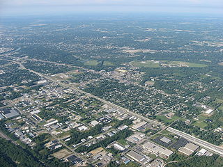
Northridge is a census-designated place (CDP) in Clark County, Ohio, United States. The population was 7,518 at the 2020 census. It is part of the Springfield, Ohio Metropolitan Statistical Area.

<span class="mw-page-title-main">Park Layne, Ohio</span> Census-designated place in Ohio, United States

Park Layne is a census-designated place (CDP) in Bethel Township, Clark County, Ohio, United States. The population of the CDP was 4,248 at the 2020 census. It is part of the Springfield, Ohio Metropolitan Statistical Area. Park Layne became a CDP in the 1980 United States Census.

<span class="mw-page-title-main">Northgate, Ohio</span> Census-designated place in Ohio, United States

Northgate is a census-designated place (CDP) in Colerain Township, Hamilton County, Ohio, United States. The population was 7,277 at the 2020 census.

<span class="mw-page-title-main">Pleasant Run Farm, Ohio</span> Census-designated place in Ohio, United States

Pleasant Run Farm is a census-designated place (CDP) in Springfield Township, Hamilton County, Ohio, United States. The population was 4,779 at the 2020 census.

<span class="mw-page-title-main">Drexel, Ohio</span> CDP in Ohio, United States

Drexel is a census-designated place (CDP) in Jefferson Township, Montgomery County, Ohio, United States. The population was 1,693 at the 2020 census.

Fort McKinley is an unincorporated community and census designated place in Harrison Township in Montgomery County, Ohio, United States. It was delineated as a census-designated place (CDP) at the 2000 census, when its population was 3,989. It was not delineated as a CDP for the 2010 census.

<span class="mw-page-title-main">Northridge, Montgomery County, Ohio</span> Unincorporated community and Census-designated place in Ohio, United States

Northridge is an unincorporated community in Harrison Township in Montgomery County, Ohio, United States. It was delineated as a census-designated place (CDP) for the 2000 census, at which time its population was 8,487. It is located directly north of the city of Dayton and is part of the Dayton Metropolitan Statistical Area.

Shiloh is a census-designated place (CDP) in Harrison Township in Montgomery County, Ohio, United States. It was delineated as a census-designated place at the 2000 census, at which time its population was 11,272. It was not delineated as a CDP at the 2010 census. It is located directly north of the city of Dayton and is part of the Dayton Metropolitan Statistical Area.

<span class="mw-page-title-main">Woodbourne-Hyde Park, Ohio</span> Unincorporated community and census-designated place in Ohio, United States

Woodbourne-Hyde Park is an unincorporated area in Washington Township in Montgomery County, Ohio, United States. A Suburb of Dayton. It was delineated as a census-designated place (CDP) at the 2000 census, at which time its population was 7,910.

<span class="mw-page-title-main">North Zanesville, Ohio</span> CDP in Ohio, United States

North Zanesville is a census-designated place (CDP) in Muskingum County, Ohio, United States, just north of the city of Zanesville, along the Muskingum River. The population was 3,116 at the 2020 census.

<span class="mw-page-title-main">Meadow Glade, Washington</span> Census-designated place in Washington, United States

Meadow Glade is a census-designated place (CDP) in Clark County, Washington, United States. The population was 2,758 at the 2020 census.

<span class="mw-page-title-main">Clifton, Ohio</span> Village in Ohio, United States

Clifton is a village in Clark and Greene counties in the U.S. state of Ohio and is home to the Clifton Mill, one of the largest water-powered grist mills still in existence. The population was 131 at the 2020 census.

<span class="mw-page-title-main">Tremont City, Ohio</span> Village in Ohio, United States

Tremont City is a village in Clark County, Ohio, United States. The population was 352 at the 2020 census. The village is part of the Springfield, Ohio Metropolitan Statistical Area.

References

  1. "ArcGIS REST Services Directory". United States Census Bureau. Retrieved September 20, 2022.
  2. 1 2 U.S. Geological Survey Geographic Names Information System: Green Meadows, Ohio
  3. 1 2 "U.S. Census website". United States Census Bureau . Retrieved 2008-01-31.
  4. "Geographic Identifiers: 2010 Demographic Profile Data (G001): Green Meadows CDP, Ohio". U.S. Census Bureau, American Factfinder. Archived from the original on January 18, 2015. Retrieved January 15, 2015.
  5. "Census of Population and Housing". Census.gov. Retrieved June 4, 2016.
  6. "2020 CENSUS - SCHOOL DISTRICT REFERENCE MAP: Clark County, OH" (PDF). U.S. Census Bureau . Retrieved 2024-09-12. - Text list