Tremont City, Ohio

Last updated

Tremont City, Ohio
Aerial Tremont City.jpg
Tremont City from the air
OHMap-doton-Tremont City.png
Location of Tremont City, Ohio
Map of Clark County Ohio Highlighting Tremont City Village.png
Location of Tremont City in Clark County
Coordinates: 40°00′58″N83°50′33″W / 40.01611°N 83.84250°W / 40.01611; -83.84250
Country United States
State Ohio
County Clark
Township German
Area
[1]
  Total0.22 sq mi (0.57 km2)
  Land0.22 sq mi (0.57 km2)
  Water0.00 sq mi (0.00 km2)
Elevation
[2]
1,004 ft (306 m)
Population
 (2020)
  Total352
  Density1,592.76/sq mi (613.84/km2)
Time zone UTC-5 (Eastern (EST))
  Summer (DST) UTC-4 (EDT)
ZIP code
45372
Area code(s) 937, 326
FIPS code 39-77308 [3]
GNIS feature ID2400001 [2]

Tremont City is a village in Clark County, Ohio, United States. The population was 352 at the 2020 census. The village is part of the Springfield, Ohio Metropolitan Statistical Area.

Contents

History

Tremont City was originally known at Treemount because the settlement was situated at the base of a hill covered with large trees. [4] A post office called Tremont was established in 1839, and the name was changed to Tremont City in 1877. [5]

Geography

According to the United States Census Bureau, the village has a total area of 0.26 square miles (0.67 km2), all of it land. [6]

Demographics

Historical population
CensusPop.Note
1880 279
1920 287
1930 2880.3%
1940 40641.0%
1950 396−2.5%
1960 4144.5%
1970 4262.9%
1980 374−12.2%
1990 49331.8%
2000 349−29.2%
2010 3757.4%
2020 352−6.1%
U.S. Decennial Census [7]

2010 census

As of the census [8] of 2010, there were 375 people, 151 households, and 99 families living in the village. The population density was 1,442.3 inhabitants per square mile (556.9/km2). There were 166 housing units at an average density of 638.5 units per square mile (246.5 units/km2). The racial makeup of the village was 98.9% White, 0.3% African American, 0.3% Asian, 0.3% from other races, and 0.3% from two or more races. Hispanic or Latino of any race were 1.6% of the population.

There were 151 households, of which 31.1% had children under the age of 18 living with them, 43.0% were married couples living together, 17.2% had a female householder with no husband present, 5.3% had a male householder with no wife present, and 34.4% were non-families. 28.5% of all households were made up of individuals, and 6.6% had someone living alone who was 65 years of age or older. The average household size was 2.48 and the average family size was 2.99.

The median age in the village was 39.4 years. 20.8% of residents were under the age of 18; 12.6% were between the ages of 18 and 24; 25.3% were from 25 to 44; 30.4% were from 45 to 64; and 10.9% were 65 years of age or older. The gender makeup of the village was 52.0% male and 48.0% female.

2000 census

As of the census [3] of 2000, there were 349 people, 134 households, and 95 families living in the village. The population density was 1,306.5 inhabitants per square mile (504.4/km2). There were 138 housing units at an average density of 516.6 units per square mile (199.5 units/km2). The racial makeup of the village was 97.42% White, 1.15% African American, 0.57% Native American, and 0.86% from two or more races. Hispanic or Latino of any race were 0.57% of the population.

There were 134 households, out of which 41.0% had children under the age of 18 living with them, 50.7% were married couples living together, 13.4% had a female householder with no husband present, and 28.4% were non-families. 24.6% of all households were made up of individuals, and 3.0% had someone living alone who was 65 years of age or older. The average household size was 2.60 and the average family size was 3.10.

In the village, the population was spread out, with 29.8% under the age of 18, 8.6% from 18 to 24, 34.4% from 25 to 44, 19.8% from 45 to 64, and 7.4% who were 65 years of age or older. The median age was 32 years. For every 100 females there were 93.9 males. For every 100 females age 18 and over, there were 97.6 males.

The median income for a household in the village was $50,000, and the median income for a family was $51,250. Males had a median income of $33,958 versus $26,875 for females. The per capita income for the village was $19,139. About 7.5% of families and 5.8% of the population were below the poverty line, including 3.2% of those under age 18 and 20.0% of those age 65 or over.

Transportation

Mad River Airport, a private airport, located one mile northeast of the city. [9]

Related Research Articles

<span class="mw-page-title-main">Mount Desert, Maine</span> Town in the state of Maine, United States

Mount Desert is a town on Mount Desert Island in Hancock County, Maine, United States. The population was 2,146 at the 2020 census. Incorporated in 1789, the town currently encompasses the villages of Otter Creek, Seal Harbor, Northeast Harbor, Somesville, Hall Quarry, and Pretty Marsh.

<span class="mw-page-title-main">Tremont, Maine</span> Town in the state of Maine, United States

Tremont is a town in Hancock County, Maine, United States. It is located on the southwestern side of Mount Desert Island, known to locals as "the quiet side."

<span class="mw-page-title-main">Trimble, Ohio</span> Village in Ohio, United States

Trimble is a village in Trimble Township, Athens County, Ohio, United States. The population was 329 at the 2020 census.

<span class="mw-page-title-main">Russellville, Ohio</span> Village in Ohio, United States

Russellville is a village in Jefferson Township, Brown County, Ohio, United States. The population was 542 at the 2020 census.

<span class="mw-page-title-main">Williamsburg, Ohio</span> Village in Ohio, United States

Williamsburg is a village in Clermont County, Ohio, United States. The population was 2,570 at the 2020 census.

<span class="mw-page-title-main">New Weston, Ohio</span> Village in Ohio, United States

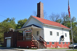
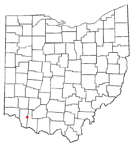
New Weston is a village in Darke County, Ohio, United States. The population was 124 at the 2020 census.

<span class="mw-page-title-main">Rossburg, Ohio</span> Village in Ohio, United States

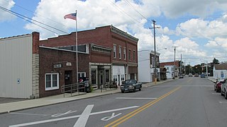
Rossburg is a village in Darke County, Ohio, United States. The population was 159 at the 2020 census.

<span class="mw-page-title-main">Yorkshire, Ohio</span> Village in Ohio, United States

Yorkshire is a village in Darke County, Ohio, United States. The population was 95 at the 2020 census.

<span class="mw-page-title-main">Amberley, Ohio</span> Village in Ohio, United States

Amberley, locally known as Amberley Village, is a village in Hamilton County, Ohio, United States. The population was 3,840 at the 2020 census.

<span class="mw-page-title-main">Elmwood Place, Ohio</span> Village in Hamilton County, Ohio, United States

Elmwood Place is a village in Hamilton County, Ohio, United States. The population was 2,087 at the 2020 census. Except for a small portion which touches neighboring St. Bernard, Elmwood Place is nearly surrounded by the city of Cincinnati.

<span class="mw-page-title-main">Golf Manor, Ohio</span> Village in Ohio, United States

Golf Manor is a village in Hamilton County, Ohio, United States. It is almost completely surrounded by the Pleasant Ridge and Roselawn neighborhoods of Cincinnati. The population was 3,814 at the 2020 census.

<span class="mw-page-title-main">Woodlawn, Ohio</span> Village in Ohio, United States

Woodlawn is a village in Hamilton County, Ohio, United States. The population was 3,916 at the 2020 census.

<span class="mw-page-title-main">Leesburg, Ohio</span> Village in Ohio, United States

Leesburg is a village in Highland County, Ohio, United States. The population was 1,273 at the 2020 census.

<span class="mw-page-title-main">Hanover, Ohio</span> Village in Ohio, United States

Hanover is a village in Licking County, Ohio, United States. The population was 1,270 at the 2020 census. The village lies along Ohio State Route 16.

<span class="mw-page-title-main">Adamsville, Ohio</span> Village in Ohio, United States

Adamsville is a village in Muskingum County, Ohio, United States. The population was 140 at the 2020 census. It is part of the Zanesville micropolitan area.

<span class="mw-page-title-main">Camden, Ohio</span> Village in Ohio, United States

Camden is a village in Preble County, Ohio, United States. The population was 1,989 at the 2020 census.

<span class="mw-page-title-main">Clinton, Ohio</span> Village in Ohio, United States

Clinton is a village in southwestern Summit County, Ohio, United States. The population was 1,197 at the 2020 Census. It is part of the Akron metropolitan area.

<span class="mw-page-title-main">Hamden, Ohio</span> Village in Ohio, United States

Hamden is a village in Vinton County, Ohio, United States. The population was 727 at the 2020 census.

<span class="mw-page-title-main">Macksburg, Ohio</span> Village in Ohio, United States

Macksburg is a village in Washington County, Ohio, United States, along the West Fork of Duck Creek. The population was 120 at the 2020 census. The village is about 28 miles (45 km) south of Cambridge, Ohio.

<span class="mw-page-title-main">Bloomdale, Ohio</span> Village in Ohio, United States

Bloomdale is a village in Wood County, Ohio, United States. The population was 665 at the 2020 census.

References

  1. "ArcGIS REST Services Directory". United States Census Bureau. Retrieved September 20, 2022.
  2. 1 2 U.S. Geological Survey Geographic Names Information System: Tremont City, Ohio
  3. 1 2 "U.S. Census website". United States Census Bureau . Retrieved January 31, 2008.
  4. Rockel, William Mahlon (1908). 20th Century History of Springfield, and Clark County, Ohio, and Representative Citizens. Biographical Publishing Company. pp.  353.
  5. "Clark County". Jim Forte Postal History. Retrieved January 12, 2016.
  6. "US Gazetteer files 2010". United States Census Bureau. Archived from the original on February 20, 2011. Retrieved January 6, 2013.
  7. "Census of Population and Housing". Census.gov. Retrieved June 4, 2015.
  8. "U.S. Census website". United States Census Bureau . Retrieved January 6, 2013.
  9. FAA Airport Form 5010 for I54 PDF , effective 2016-02-10