Holiday Valley, Ohio

Last updated
Holiday Valley, Ohio
OHMap-doton-Holiday Valley.png
Location of Holiday Valley, Ohio
Coordinates: 39°51′13″N83°57′43″W / 39.85361°N 83.96194°W / 39.85361; -83.96194
Country United States
State Ohio
County Clark
Township Mad River
Area
[1]
  Total1.82 sq mi (4.71 km2)
  Land1.82 sq mi (4.71 km2)
  Water0.00 sq mi (0.00 km2)
Elevation
[2]
984 ft (300 m)
Population
 (2020)
  Total1,480
  Density813.19/sq mi (313.96/km2)
Time zone UTC-5 (Eastern (EST))
  Summer (DST) UTC-4 (EDT)
FIPS code 39-35868 [3]
GNIS feature ID2393052 [2]

Holiday Valley is a census-designated place (CDP) in Mad River Township, Clark County, Ohio, United States. The population was 1,480 at the 2020 census. It is part of the Springfield, Ohio Metropolitan Statistical Area. Holiday Valley became a CDP in the 1990 United States Census. [4]

Contents

Geography

Holiday Valley is located in southwestern Clark County in the southwest part of Mad River Township. It is bordered on the northeast by unincorporated Green Meadows and a small portion of the village of Enon, and on the south by Bath Township in Greene County. Dayton Springfield Road forms the northwestern edge of the CDP, leading southwest 15 miles (24 km) to downtown Dayton and northeast 10 miles (16 km) to the center of Springfield.

According to the United States Census Bureau, the CDP has a total area of 1.8 square miles (4.7 km2), all of it land. [5]

Demographics

Historical population
CensusPop.Note
1990 1,243
2000 1,71237.7%
2010 1,510−11.8%
2020 1,480−2.0%
U.S. Decennial Census [6] [7] [4]

As of the census [3] of 2000, there were 1,712 people, 562 households, and 458 families residing in the CDP. The population density was 825.4 inhabitants per square mile (318.7/km2). There were 588 housing units at an average density of 283.5 per square mile (109.5/km2). The racial makeup of the CDP was 95.68% White, 1.46% African American, 0.12% Native American, 0.82% Asian, 0.06% Pacific Islander, 0.58% from other races, and 1.29% from two or more races. Hispanic or Latino of any race were 1.40% of the population.

There were 562 households, out of which 34.0% had children under the age of 18 living with them, 70.1% were married couples living together, 10.0% had a female householder with no husband present, and 18.5% were non-families. 16.5% of all households were made up of individuals, and 5.7% had someone living alone who was 65 years of age or older. The average household size was 2.65 and the average family size was 2.96.

In the CDP the population was spread out, with 22.5% under the age of 18, 4.4% from 18 to 24, 25.5% from 25 to 44, 26.5% from 45 to 64, and 21.1% who were 65 years of age or older. The median age was 43 years. For every 100 females there were 88.3 males. For every 100 females age 18 and over, there were 81.8 males.

The median income for a household in the CDP was $58,281, and the median income for a family was $63,464. Males had a median income of $46,923 versus $30,000 for females. The per capita income for the CDP was $21,601. About 2.6% of families and 12.2% of the population were below the poverty line, including 8.3% of those under age 18 and 32.3% of those age 65 or over.

Education

The school district is Greenon Local School District. [8]

Related Research Articles

<span class="mw-page-title-main">Hidden Valley, Indiana</span> Census-designated place in Indiana, United States

Hidden Valley is a private residential community in Dearborn County, Indiana, United States. For statistical purposes it is a census-designated place (CDP), with a population of 5,387 at the 2010 census, up from 4,417 at the 2000 census.

<span class="mw-page-title-main">Neffs, Ohio</span> Census-designated place in Ohio, United States

Neffs is an unincorporated community and census-designated place in northwestern Pultney Township, Belmont County, Ohio, United States. The population was 878 at the 2020 census. It is part of the Wheeling metropolitan area.

<span class="mw-page-title-main">Beckett Ridge, Ohio</span> Census-designated place in Ohio, United States

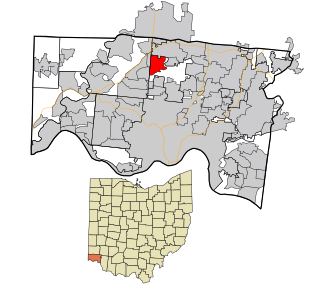
Beckett Ridge is a census-designated place (CDP) in West Chester Township, Butler County, Ohio, United States. The population was 9,192 at the 2020 census.

<span class="mw-page-title-main">Ross, Ohio</span> Census-designated place in Ohio, United States

Ross is a census-designated place (CDP) in Ross Township, Butler County, Ohio, United States. The population was 3,478 at the 2020 census. Ross sits along U.S. Route 27 between Cincinnati, Ohio and Oxford, Ohio. Ross is part of the Cincinnati metropolitan area.

<span class="mw-page-title-main">Crystal Lakes, Ohio</span> Census-designated place in Ohio, United States

Crystal Lakes is a census-designated place (CDP) in Clark County, Ohio, United States. The population was 1,394 at the 2020 census. It is part of the Springfield, Ohio Metropolitan Statistical Area.

<span class="mw-page-title-main">Green Meadows, Ohio</span> Census-designated place in Ohio, United States

Green Meadows is a census-designated place (CDP) in Mad River Township, Clark County, Ohio, United States, on the west side of Enon. The population was 2,373 at the 2020 census. It is part of the Springfield, Ohio Metropolitan Statistical Area.

<span class="mw-page-title-main">Northridge, Clark County, Ohio</span> Census-designated place in Ohio, United States

Northridge is a census-designated place (CDP) in Clark County, Ohio, United States. The population was 7,518 at the 2020 census. It is part of the Springfield, Ohio Metropolitan Statistical Area.

<span class="mw-page-title-main">Park Layne, Ohio</span> Census-designated place in Ohio, United States

Park Layne is a census-designated place (CDP) in Bethel Township, Clark County, Ohio, United States. The population of the CDP was 4,248 at the 2020 census. It is part of the Springfield, Ohio Metropolitan Statistical Area. Park Layne became a CDP in the 1980 United States Census.

<span class="mw-page-title-main">Mount Carmel, Ohio</span> Census-designated place in Ohio, United States

Mount Carmel is a census-designated place (CDP) in Clermont County, Ohio, United States. The population was 4,828 at the 2020 census.

<span class="mw-page-title-main">Withamsville, Ohio</span> Census-designated place in Ohio, United States

Withamsville is a census-designated place (CDP) in Pierce and Union townships of Clermont County, Ohio, United States. The population was 7,357 at the 2020 census.

<span class="mw-page-title-main">Lake Darby, Ohio</span> Census-designated place in Ohio, United States

Lake Darby is an unincorporated community and census-designated place in Franklin County, Ohio, United States, located mostly in Prairie Township and partly in Brown Township. It is more commonly known among locals as Darby Estates, which is also the name of the older housing development there, with the newer development called "West Point". As of the 2020 census, the CDP had a population of 4,731.

<span class="mw-page-title-main">Chesterland, Ohio</span> Census-designated place in Ohio, United States

Chesterland is a census-designated place (CDP) in Geauga County, Ohio, United States. As of the 2020 census, the CDP had a population of 7,074.

<span class="mw-page-title-main">Grandview, Hamilton County, Ohio</span> Census-designated place in Ohio, United States

Grandview is a census-designated place (CDP) in Hamilton County, Ohio, United States. The population was 1,312 at the 2020 census.

<span class="mw-page-title-main">Pleasant Run, Ohio</span> Census-designated place in Ohio, United States

Pleasant Run is a census-designated place (CDP) in Colerain Township, Hamilton County, Ohio, United States. The population was 4,861 at the 2020 census.

<span class="mw-page-title-main">Pleasant Run Farm, Ohio</span> Census-designated place in Ohio, United States

Pleasant Run Farm is a census-designated place (CDP) in Springfield Township, Hamilton County, Ohio, United States. The population was 4,779 at the 2020 census.

<span class="mw-page-title-main">White Oak, Ohio</span> Census-designated place in Ohio, United States

White Oak is a census-designated place (CDP) in Hamilton County, Ohio, United States. It is seven miles northwest of Cincinnati. The population was 19,541 at the 2020 census. White Oak is situated in both Green Township and Colerain Township.

<span class="mw-page-title-main">Woodlyn, Pennsylvania</span> Census-designated place in Pennsylvania, United States

Woodlyn is a census-designated place (CDP) in Delaware County, Pennsylvania, United States. The population was 9,485 at the 2010 census, down from 10,036 at the 2000 census. It is a part of Ridley Township, and children residing within the community generally attend schools in the Ridley School District. Woodlyn is served by the Woodlyn Fire Co. for fire, rescue and EMS services.

<span class="mw-page-title-main">Loveland Park, Ohio</span> Census-designated place in Ohio, United States

Loveland Park is a census-designated place (CDP) located in Symmes Township, Hamilton County and Deerfield Township, Warren County, in the southwestern part of the U.S. state of Ohio. The CDP is named after the city of Loveland. The population was 1,737 at the 2020 census.

<span class="mw-page-title-main">New Burlington, Hamilton County, Ohio</span> Census-designated place in Ohio, United States

New Burlington is a census-designated place (CDP) in Springfield Township, Hamilton County, Ohio, United States. The population was 5,049 at the 2020 census.

<span class="mw-page-title-main">Skyline Acres, Ohio</span> Census-designated place in Ohio, United States

Skyline Acres is a census-designated place (CDP) in Colerain and Springfield townships, Hamilton County, Ohio, United States. The population was 1,446 at the 2020 census.

References

  1. "ArcGIS REST Services Directory". United States Census Bureau. Retrieved September 20, 2022.
  2. 1 2 U.S. Geological Survey Geographic Names Information System: Holiday Valley, Ohio
  3. 1 2 "U.S. Census website". United States Census Bureau . Retrieved 2008-01-31.
  4. 1 2 "1990 Profiles of General Demographic Characteristics" (PDF). US Census Bureau. Retrieved January 20, 2024.
  5. "Geographic Identifiers: 2010 Demographic Profile Data (G001): Holiday Valley CDP, Ohio". U.S. Census Bureau, American Factfinder. Archived from the original on January 18, 2015. Retrieved January 15, 2015.
  6. "Census of Population and Housing". Census.gov. Retrieved June 4, 2016.
  7. "2000 Profiles of General Demographic Characteristics" (PDF). US Census Bureau. Retrieved January 20, 2024.
  8. "2020 CENSUS - SCHOOL DISTRICT REFERENCE MAP: Clark County, OH" (PDF). U.S. Census Bureau . Retrieved 2024-09-12. - Text list