Greenland, Colorado

Last updated

Greenland, Colorado
Greenland, Colorado.JPG
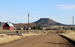
East Noe Road in Greenland, with Larkspur Butte in the distance.
USA Colorado location map.svg
Red pog.svg
Greenland
Location in Douglas County and state of Colorado
Coordinates: 39°10′57″N104°51′19″W / 39.18250°N 104.85528°W / 39.18250; -104.85528
Country Flag of the United States.svg  United States
State Flag of Colorado.svg  State of Colorado
County Douglas County [1]
Government
  Type Unincorporated Community [1]
Area
  Total1.3 sq mi (3.5 km2)
  Land1.3 sq mi (3.5 km2)
  Water0 sq mi (0 km2)
Elevation
[2]
6,726 ft (2,050 m)
Time zone UTC-7 (MST)
  Summer (DST) UTC-6 (MDT)
ZIP code [3]
80118 (Larkspur)
Area code 303
FIPS code 08-43550
Primary Major Routes I-25 (CO).svg US 85.svg US 87.svg
Secondary Major Routes Colorado 105.svg

Greenland is an unincorporated community in Douglas County, Colorado, United States. Greenland is located off Exit 167 on Interstate 25. The largest nearby incorporated towns are Larkspur and Monument: Larkspur lies about 7 miles northeast and Monument about 13 miles south of the community. The U.S. Post Office at Larkspur (ZIP Code 80118) now serves the Greenland postal addresses. [3]

Contents

A post office called Greenland was established in 1873, and remained in operation until 1959. [4] The community was named for the green character of the original town site. [5]

Activities

A series of trail races of varying distances are held in Greenland each May. [6] Douglas County Division of Open Space and Natural Resources manages Spruce Meadows Open Space and Trail, which is located on the southern edge of Greenland. [7] Spruce Meadows Trail is a largely flat 8.6 mile-long path near Spruce Mountain that affords a view of Pikes Peak. [8]

Transportation

Roads

Greenland is Directly served by I-25, US-85 and US-87 via. exit 167 at Noe Rd. But it is also served by SH-105.

Rail

The Colorado Joint Line (owned by Union Pacific and BNSF) operates through Greenland. There are no passenger trains that operate in and out of Greenland, though.

See also

Related Research Articles

<span class="mw-page-title-main">Douglas County, Colorado</span> County in Colorado, United States

Douglas County is a county located in the U.S. state of Colorado. As of the 2020 Census, the population was 357,978. The county is named in honor of U.S. Senator Stephen A. Douglas. The county seat is Castle Rock.

<span class="mw-page-title-main">Castle Rock, Colorado</span> Town in Colorado, United States

Castle Rock is a home rule town that is the county seat and the most populous municipality of Douglas County, Colorado, United States. The town population was 73,158 at the 2020 United States Census, a 51.68% increase since the 2010 United States Census. Castle Rock is the most populous Colorado town and the 16th most populous Colorado municipality. Castle Rock is a part of the Denver-Aurora-Lakewood, CO Metropolitan Statistical Area and the Front Range Urban Corridor.

<span class="mw-page-title-main">Aurora, Colorado</span> City in Colorado, United States

Aurora is a home rule municipality located in Arapahoe, Adams, and Douglas counties, Colorado, United States. The city's population was 386,261 at the 2020 United States Census with 336,035 residing in Arapahoe County, 47,720 residing in Adams County, and 2,506 residing in Douglas County. Aurora is the third most populous city in the State of Colorado and the 51st most populous city in the United States. Aurora is a principal city of the Denver–Aurora–Lakewood Metropolitan Statistical Area (MSA) and a major city of the Front Range Urban Corridor.

<span class="mw-page-title-main">Strasburg, Colorado</span> Census Designated Place in Colorado, United States

Strasburg is an unincorporated town located just 30 minutes east of downtown Denver along the I-70 corridor. It is home to Strasburg School District 31-J, and there are several small businesses, medical clinics, and a post office. Strasburg is a census-designated place (CDP) located in and governed by Adams and Arapahoe counties, Colorado, United States. The CDP is a part of the Denver–Aurora–Lakewood, CO Metropolitan Statistical Area. The Strasburg post office has the ZIP Code 80136. At the United States Census 2020, the population of the Strasburg CDP was 3,307.

<span class="mw-page-title-main">Byers, Colorado</span> Census Designated Place in Colorado, United States

Byers is an unincorporated town, a post office, and a census-designated place (CDP) located in and governed by Arapahoe County, Colorado, United States. The CDP is a part of the Denver–Aurora–Lakewood, CO Metropolitan Statistical Area. The Byers post office has the ZIP Code 80103. At the United States Census 2020, the population of the Byers CDP was 1,322.

<span class="mw-page-title-main">Superior, Colorado</span> Town in Colorado, United States

Superior is a statutory town in Boulder County, Colorado, United States, with a small, uninhabited segment of land area extending into Jefferson County. According to the 2020 census, the population of the city was 13,094.

<span class="mw-page-title-main">Acres Green, Colorado</span> Census Designated Place in Colorado, United States

Acres Green is an unincorporated community and a census-designated place (CDP) located in and governed by Douglas County, Colorado, United States. The CDP is a part of the Denver–Aurora–Lakewood, CO Metropolitan Statistical Area. The population of the Acres Green CDP was 2,922 at the 2020 United States Census. The community lies in ZIP Code 80124.

<span class="mw-page-title-main">Castle Pines, Colorado</span> City in Colorado, United States

The City of Castle Pines is a home rule municipality located in Douglas County, Colorado, United States. The city population was 11,036 at the 2020 United States Census. Castle Pines is a part of the Denver–Aurora–Lakewood, CO Metropolitan Statistical Area and the Front Range Urban Corridor. The city is located north of the Town of Castle Rock and south of the City of Lone Tree, Colorado.

<span class="mw-page-title-main">Franktown, Colorado</span> Census Designated Place in Colorado, United States

Franktown is an unincorporated town, a post office, and a census-designated place (CDP) located in and governed by Douglas County, Colorado, United States. The CDP is a part of the Denver–Aurora–Lakewood, CO Metropolitan Statistical Area. The Franktown post office has the ZIP Code 80116. At the United States Census 2020, the population of the Franktown CDP was 409.

<span class="mw-page-title-main">Larkspur, Colorado</span> Town in Colorado, United States

Larkspur is a home rule municipality in Douglas County, Colorado, United States. The town population was 206 at the 2020 census. Each year, on weekends in June, July and August, the Colorado Renaissance Festival is held in the hills just west of the town. The town is served by Larkspur Elementary School, a K-6 school in the Douglas County school district. The according to William Bright the town was named for the plains larkspur.

<span class="mw-page-title-main">Lone Tree, Colorado</span> City in Colorado, United States

The City of Lone Tree is a home rule municipality located in northern Douglas County, Colorado, United States. Lone Tree is a part of the Denver–Aurora–Lakewood, CO Metropolitan Statistical Area. The city population was 14,253 at the 2020 United States Census.

<span class="mw-page-title-main">Louviers, Colorado</span> Census Designated Place in Colorado, United States

Louviers is an unincorporated town, a post office, and a census-designated place (CDP) located in and governed by Douglas County, Colorado, United States. The CDP is a part of the Denver–Aurora–Lakewood, CO Metropolitan Statistical Area. The Louviers post office has the ZIP Code 80131. At the United States Census 2020, the population of the Louviers CDP was 293.

<span class="mw-page-title-main">Perry Park, Colorado</span> Census Designated Place in Colorado, United States

Perry Park is an unincorporated community and a census-designated place (CDP) located in Douglas County, Colorado, United States. The CDP is a part of the Denver–Aurora–Lakewood, CO Metropolitan Statistical Area. The population of the Perry Park CDP was 1,932 at the United States Census 2020. The Perry Park Metropolitan District and the Perry Park Water & Sanitation District provide services. The Larkspur post office serves the area.

<span class="mw-page-title-main">Sedalia, Colorado</span> Census Designated Place in Colorado, United States

Sedalia is an unincorporated town, a post office, and a census-designated place (CDP) located in and governed by Douglas County, Colorado, United States. The CDP is a part of the Denver–Aurora–Lakewood, CO Metropolitan Statistical Area. The Sedalia post office has the ZIP Code 80135. At the United States Census 2020, the population of the Sedalia CDP was 177.

<span class="mw-page-title-main">Evergreen, Colorado</span> Census Designated Place in Colorado, United States

Evergreen is an unincorporated town, a post office, and a census-designated place (CDP) located in and governed by Jefferson County, Colorado, U.S. The CDP is a part of the Denver–Aurora–Lakewood, CO Metropolitan Statistical Area. The Evergreen post office has the ZIP Codes 80439 and 80437. At the 2020 census, the population of the Evergreen CDP was 9,307. The Evergreen Metropolitan District provides services.

<span class="mw-page-title-main">Kittredge, Colorado</span> Census Designated Place in Colorado, United States

Kittredge is an unincorporated town, a post office, and a census-designated place (CDP) located in and governed by Jefferson County, Colorado, United States. The CDP is a part of the Denver–Aurora–Lakewood, CO Metropolitan Statistical Area. The Kittredge post office has the ZIP code 80457. At the United States Census 2020, the population of the Kittredge CDP was 1,308.

<span class="mw-page-title-main">Elbert, Colorado</span> Census Designated Place in Colorado, United States

Elbert is an unincorporated town, a post office, and a census-designated place (CDP) located in and governed by Elbert County, Colorado, United States. The CDP is a part of the Denver–Aurora–Lakewood, CO Metropolitan Statistical Area. The Elbert post office has the ZIP Code 80106. At the United States Census 2020, the population of the Elbert CDP was 188.

<span class="mw-page-title-main">Watkins, Colorado</span> Census Designated Place in Colorado, United States

Watkins is an unincorporated town and a census-designated place (CDP) located in and governed by Arapahoe and Adams counties, Colorado, United States. The CDP is a part of the Denver–Aurora–Lakewood, CO Metropolitan Statistical Area. The town is surrounded by Aurora and its post office, which lies within the Aurora city limits, has the ZIP Code 80137. At the United States Census 2020, the population of the Watkins CDP was 682.

<span class="mw-page-title-main">Sterling Ranch, Colorado</span> Census Designated Place in Colorado, United States

Sterling Ranch is an unincorporated community and a census-designated place (CDP) located in and governed by Douglas County, Colorado, United States. The population was 1,789 at the 2020 census. The CDP is a part of the Denver–Aurora–Lakewood, CO Metropolitan Statistical Area. Douglas County governs the unincorporated community and the Sterling Ranch Community Authority Board provides services through several metropolitan districts. The Littleton post office serves the area.

<span class="mw-page-title-main">Dawson Butte</span>

Dawson Butte, elevation 7,474 ft (2,278 m), is a flat-topped mountain in Douglas County, Colorado. Adjacent to the mountain is the Dawson Butte Open Space, owned by Douglas County and managed by the County's Division of Open Space and Natural Resources.

References

  1. 1 2 "Active Colorado Municipalities". State of Colorado, Department of Local Affairs. Archived from the original on December 12, 2009. Retrieved September 1, 2007.
  2. "US Board on Geographic Names". United States Geological Survey. October 25, 2007. Retrieved January 31, 2008.
  3. 1 2 "ZIP Code Lookup". United States Postal Service. December 27, 2006. Archived from the original (JavaScript/HTML) on November 22, 2010. Retrieved December 27, 2006.
  4. "Post offices". Jim Forte Postal History. Retrieved June 25, 2016.
  5. Dawson, John Frank. Place names in Colorado: why 700 communities were so named, 150 of Spanish or Indian origin. Denver, CO: The J. Frank Dawson Publishing Co. p. 25.
  6. "Greenland Trail Races". Colorado Runner Events. Archived from the original on July 15, 2021. Retrieved July 14, 2021.
  7. "Spruce Meadows Open Space and Trail". Castle Rock, CO: Douglas County Division of Open Space and Natural Resources. Archived from the original on July 15, 2021. Retrieved July 14, 2021.
  8. "Spruce Meadows Open Space Trail". Castle Rock, CO: Douglas County Division of Open Space and Natural Resources. Archived from the original on July 15, 2021. Retrieved July 14, 2021.