Cottonwood, Colorado

Last updated

Cottonwood, Parker
Douglas County Colorado Incorporated and Unincorporated areas Cottonwood Highlighted.svg
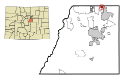
Location of Cottonwood in Douglas County, Colorado
Coordinates: 39°33′45″N104°48′07″W / 39.56250°N 104.80194°W / 39.56250; -104.80194 [1]
Country Flag of the United States (23px).png  United States
State Flag of Colorado.svg  State of Colorado
County Douglas County
County Town of Parker
Elevation
[1]
1,753 m (5,752 ft)
Population
 (2000)
  Total
931
Time zone UTC-7 (MST)
  Summer (DST) UTC-6 (MDT)
Area codes 303 & 720
GNIS feature ID 1852842 [1]

Cottonwood is a neighborhood in the Parker, Colorado. A former census-designated place (CDP), the population was 931 at the 2000 census.

Contents

Climate

This climate type is usually found in the outskirts of true deserts in low-latitude, semiarid regions. It has a cooler, wetter winter resulting from the higher latitude and mid-latitude frontal cyclone activity. Annual precipitation totals are greater than in tropical and subtropical desert climates. Yearly variations in amount are not as extreme as in the true deserts but are nevertheless large. The Köppen Climate Classification subtype for this climate is "BSk". (Tropical and Subtropical Steppe Climate).

Climate data for Cottonwood, Colorado
MonthJanFebMarAprMayJunJulAugSepOctNovDecYear
Mean daily maximum °F (°C)43
(6)
46
(8)
51
(11)
60
(16)
69
(21)
80
(27)
86
(30)
84
(29)
77
(25)
66
(19)
52
(11)
45
(7)
63
(17)
Mean daily minimum °F (°C)15
(−9)
18
(−8)
23
(−5)
31
(−1)
40
(4)
49
(9)
55
(13)
54
(12)
46
(8)
35
(2)
23
(−5)
17
(−8)
34
(1)
Average precipitation inches (mm)0.3
(7.6)
0.3
(7.6)
0.9
(23)
1.3
(33)
2.5
(64)
1.9
(48)
2.2
(56)
1.9
(48)
1.1
(28)
0.8
(20)
0.7
(18)
0.3
(7.6)
14.1
(360)
Source: Weatherbase [2]

See also

References

  1. 1 2 3 U.S. Geological Survey Geographic Names Information System: Cottonwood, Colorado
  2. "Weatherbase.com :PARKER, COLORADO (closest city on record to Cottonwood, Colorado)". Weatherbase. 2013. Retrieved on May 5, 2013.