Grendon Underwood is a village and civil parish in west Buckinghamshire, England, near the border with Oxfordshire. The village sits between Woodham and Edgcott, near the Roman road Akeman Street, and around 10 miles (16 km) north-west of Aylesbury. At the 2011 Census, the population of the civil parish was 1,625.

Littleworth Common is a 16.1-hectare (40-acre) biological Site of Special Scientific Interest west of Farnham Common in Buckinghamshire. It is Common land owned by South Bucks District Council.

Kings and Bakers Woods and Heaths is a 212.8-hectare (526-acre) Site of Special Scientific Interest (SSSI) between Heath and Reach in Bedfordshire and Great Brickhill in Buckinghamshire. The site is mainly in Bedfordshire but includes Rammamere Heath in Buckinghamshire. It was notified in 1984 under Section 28 of the Wildlife and Countryside Act 1981, and the local planning authorities are Central Bedfordshire Council and Aylesbury Vale Council. Part of it is a National Nature Reserve, and part of it is a nature reserve managed by the Wildlife Trust for Bedfordshire, Cambridgeshire and Northamptonshire. it is also a Nature Conservation Review site.

Pitstone Hill is a 22.9-hectare (57-acre) biological Site of Special Scientific Importance east of Pitstone in Buckinghamshire. It is in the Chilterns Area of Outstanding Natural Beauty, and is crossed by the Ridgeway National Trail.

Knebworth Woods is a 120.8-hectare (299-acre) biological Site of Special Scientific Interest in Knebworth, immediately south of Stevenage in Hertfordshire. The planning authority is North Hertfordshire District Council.

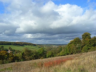
Bacombe and Coombe Hills is a 76.4-hectare (189-acre) biological Site of Special Scientific Interest in Upper Bacombe in Buckinghamshire. Bacombe Hill was formerly owned by Buckinghamshire County Council, which transferred it to Berkshire, Buckinghamshire and Oxfordshire Wildlife Trust in 2014. Coombe Hill is owned by the National Trust.

Bradenham Woods, Park Wood and The Coppice is a 129.1-hectare (319-acre) biological Site of Special Scientific Interest in Bradenham in Buckinghamshire. It is in the Chilterns Area of Outstanding Natural Beauty, and it is described in A Nature Conservation Review. The site is part of the Bradenham Estate, which is owned by the National Trust. It is also designated a Special Area of Conservation. Grim's Ditch, a Scheduled Monument, runs through the site.

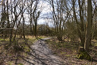
Finemere Wood is a 45.7-hectare (113-acre) biological Site of Special Scientific Interest near Quainton in Buckinghamshire. It is managed by the Berkshire, Buckinghamshire and Oxfordshire Wildlife Trust and the planning authorities are Aylesbury Vale District Council and Buckinghamshire County Council.

Gomm Valley is a 4-hectare (9.9-acre) biological Site of Special Scientific Interest in Micklefield, a district of High Wycombe in Buckinghamshire. It is managed by the Berkshire, Buckinghamshire and Oxfordshire Wildlife Trust and is part of the Chilterns Area of Outstanding Natural Beauty. The local planning authority is Wycombe District Council.

Grangelands and Pulpit Hill is a 25.5-hectare (63-acre) biological Site of Special Scientific Interest in Cadsden in Buckinghamshire. It lies within the Chilterns Area of Outstanding Natural Beauty, and the planning authorities are Wycombe District Council and Buckinghamshire County Council.

Hodgemoor Wood is a biological Site of Special Scientific Interest in Chalfont St Giles in Buckinghamshire. It is in the Chilterns Area of Outstanding Natural Beauty, and most of it is leased by Buckinghamshire County Council to the Forestry Commission.

Hollowhill and Pullingshill Woods is a 23-hectare biological Site of Special Scientific Interest near Marlow in Buckinghamshire. It is in the Chilterns Area of Outstanding Natural Beauty, and the Chilterns Beechwoods Special Area of Conservation. The local planning authorities are Wycombe District Council and Buckinghamshire County Council. Pullingshill Wood is owned by the Woodland Trust, and Hollowhill Wood was formerly owned by Buckinghamshire County Council, but was transferred to the Berkshire, Buckinghamshire and Oxfordshire Wildlife Trust. Since November 2015 the 7.8-hectare site has been managed by the Trust as "Hog and Hollowhill Woods".

Howe Park Wood is a 21.4-hectare (53-acre) Site of Special Scientific Interest in Tattenhoe, a district of Milton Keynes in Buckinghamshire. It is owned by Milton Keynes City Council and managed by Milton Keynes Parks Trust.

Homefield Wood is a 6.1-hectare (15-acre) Site of Special Scientific Interest in Hambleden in Buckinghamshire. It is owned by the Forestry Commission, and managed by the Berkshire, Buckinghamshire and Oxfordshire Wildlife Trust. It is part of the Chilterns Area of Outstanding Natural Beauty.

Dancersend is an 81.3-hectare (201-acre) Site of Special Scientific Interest (SSSI) south of Aston Clinton in Buckinghamshire. Part of the site is managed by the Forestry Commission and part by the Berkshire, Buckinghamshire and Oxfordshire Wildlife Trust (BBOWT). The BBOWT's 47 hectare nature reserve, called Dancersend with Pavis Woods, extends into fields west of the SSSI. It is in the Chilterns Areas of Outstanding Natural Beauty.
Millfield Wood is a 9.5-hectare (23-acre) biological Site of Special Scientific Interest north of High Wycombe in Buckinghamshire. It is owned and managed by the Berkshire, Buckinghamshire and Oxfordshire Wildlife Trust, and it is in the Chilterns Areas of Outstanding Natural Beauty.

Swain's Wood is a 16.2-hectare (40-acre) biological Site of Special Scientific Interest west of Turville in Buckinghamshire. It is in the Chilterns Area of Outstanding Natural Beauty, and is managed by the Berkshire, Buckinghamshire and Oxfordshire Wildlife Trust.

Shabbington Woods Complex is a 305.6-hectare (755-acre) biological Site of Special Scientific Interest (SSSI) between Horton-cum-Studley and Worminghall in Buckinghamshire. It comprises Shabbington Wood, Bernwood Forest, Hell Coppice, Oakley Wood and York's Wood. Shabbington Wood is owned by the Forestry Commission, and a small area of 7.5 hectares called Bernwood Meadows is managed by the Berkshire, Buckinghamshire and Oxfordshire Wildlife Trust.

Ham Home-cum-Hamgreen Woods is a 23.2-hectare (57-acre) biological Site of Special Scientific Interest in Kingswood near Grendon Underwood in Buckinghamshire. It is composed of two separate areas, Ham Home Wood and Hamgreen Wood, and is a small part of the formerly extensive Bernwood Forest.
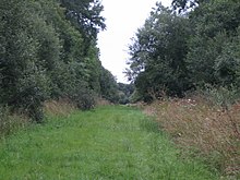
Rushbeds Wood is a 56-hectare (140-acre) nature reserve near Wotton Underwood in Buckinghamshire, managed by the Berkshire, Buckinghamshire and Oxfordshire Wildlife Trust (BBOWT). It is a surviving fragment of the ancient Bernwood Forest. The reserve is part of Rushbeds Wood and Railway Cutting, an 80.2-hectare (198-acre) biological Site of Special Scientific Interest. This includes a section of the Chiltern Main Line railway cutting, which runs along the north-east side of the BBOWT reserve.